The East Bank: Walking the Antihistamine Trail
Posted in London on Saturday 6th July 2019 at 11:07pm
The train doors clattered open, and I stepped onto the platform of what felt like an old, rural station which long predated the electric Underground train I'd arrived on. I was the only passenger to alight, all interest apparently being focused on city-bound trains on this pleasant summer morning. It had been a long, hot ride out from the stuccoed villas of Lancaster Gate where I'd descended into the earth.
Less than twenty miles away from Bethnal Green, the automatic doors of the tube train open onto the land of Greenleigh. On one side of the railway are cows at pasture, on the other the new housing estate.Family and Kinship in East London, Michael Young & Peter Wilmott, 1957
Alighting at Debden felt like a return to more innocent age of these walks: when I'd first ventured along the valley of the River Roding, it felt like something of a revelation. I'd been straying further afield for some time, worrying the greener edges of London - but that walk truly took me out of my comfort zone, and reminded me what my walking boots were really for. At the end of that summer day, drenched by an unexpected downpour in Ilford, I knew my horizons had expanded. Yet again I'd strayed outside the self-imposed cordon, pressed against the membrane of anxiety which the edge of the map always offered. Today, the valley was dry and hazy, the intermittent summer having returned in the week or so before my walk, frazzling the grasses and drying the earth underfoot. I started out with a quick trip for provisions which involved a detour into Debden's Broadway - a wide boulevard between terraces of shops and maisonettes opened in 1958. Debden was Young and Wilmott's 'Greenleigh', and when the shops of the Broadway finally opened for business, the earliest parts of the London County Council estate in Debden had already been in existence for a decade. This suburban extension which almost joined Loughton to Theydon Bois was largely unwanted when first mooted between the wars, not least by locals who feared overdevelopment of their relatively rural surroundings. Housing between the two villages was initially proposed under the powers granted to the LCC by the Housing Act 1919, but work did not commence until after the Second World War in 1945 by which time the need was greater than ever: the densely populated East End had been pulverised by enemy bombing, and the population had already begun to scatter into the edges of Essex. The acquisition of land near the Roding at Oakwood Hill for prefabricated homes was the beginning of a much larger development which would see the estate spread north and east, crossing Chigwell Lane and finally stretching along the western side of the railway. Expediency and cost meant that a number of prefabrication and building systems were employed, and for all the talk of a warren of identical houses, the estate remains in fact a mixture of interesting and novel styles of home from the Laing Easi-form to the Cornish Unit. For the locals though this was no succour: the trade between necessity and the destruction of the Essex countryside was hard to balance. Donald Gillingham, the hyper-local naturalist who rarely roamed more than a few miles from his home in the Roding Valley wrote of these times:
The war was not over. A new invasion had begun - all the more tragic because, perhaps, necessary. It had begun insidiously when surveyors went out like a fifth column and drove in red and yellow stakes.Unto The Fields - Donald Gillingham, 1955
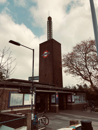
Tensions rose further when it became clear that the LCC estate would primarily house displaced Londoners: either those bombed out of their homes, or others decanted to allow clearance of urban slums. There would be few homes in Debden for the local families in Loughton, which too was growing into a sizeable town. Instead, those locals seeking properties would likely be offered tenancies in Essex County Council's own Harlow New Town some ten miles to the north. With the identity of this growing suburb contested and the links to Loughton and Essex now tenuous at best, the question of a name for the area was equally fraught with local politics. The issue was settled in 1949 when the Great Eastern Railway's Chigwell Lane station became London Underground's Debden Station on the newly electrified extension of the Central Line. The name, drawn from the nearby hamlet of Debden Green, paid ancient homage to the valley of the Roding which the estate bordered. But there is no escaping, even today, the sense that this is a little bit of London outside its boundaries. The bright red buses turning at the end of the Broadway, the clatter of the Central Line trains heading for the distant city and the hum of the M11 all draw the ear and the eye south and west. I was going to follow the same line today, for a little while at least.
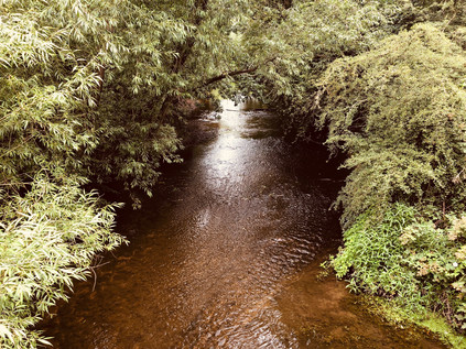
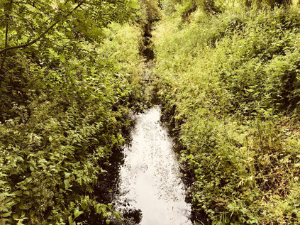
I retraced my steps, heading under the railway bridge towards the Motorway and knowing that I'd soon be leaving the urban fringe behind for a while. The familiar gateway to the green path along the river was a welcome sight, and once again I experienced the sense of plunging into the countryside despite walking a narrow margin between road and railway. The cracked asphalt of the path had deteriorated over the previous two years, grass and weed pressing up through the untended surface. Tall thistles and an impressive crop of nettles swayed beside the path, almost hiding the busy trickle of the river from view. Insects flitted across my path, the drone of the M11 almost hidden by the constant buzz of life in the grasses. When I'd been here before I'd hesitated: this felt too far off the beaten track, too unlike my preconceptions of the urban rivers of London. But I'd persisted in walking the meanders, sticking to the paths which were vague then and even harder to discern today as the grass had converted alternate weeks of rain and sun into spurts of furious growth. The reward was the surprising peace of the Roding Valley and it was good to be back. I was determined though, to walk the eastern bank as far as I could today: last time, this had eluded me. The one crossing point I'd planned to take was blocked by a locked entrance gate, and I'd found myself confined to the western side of the river and a number of circuitous diversions from the bank. So at the first opportunity, the Charlie Moules Bridge, I made my crossing. The bridge, built in the 1950s following a campaign by Councillor Moules to link the recently acquired meadows in Chigwell with the band of development along the western side of the river, delivered me into silent grassland. The barely visible path was a worn groove leading into the treeline ahead while clouds brooded over Essex to the east. I wondered if I would once again find my progress halted by a storm? Reflecting on my first visit, I suspected the sight of these remote, quiet meadow paths would have sent me scurrying back to the relatively civilised western bank - but today it was perfect. Barely more than a trail through the ribbon of woodland on this side of the river, the tree cover occasionally left sheltered patches of the path surprisingly muddy underfoot. I saw and heard no-one until the path came alongside the fishing lakes and the distant, low voices of anglers comparing catches could be heard over the river. A little way ahead, I was faced with a decision - both forks of which led to a diversion. I could head west and retrace my route from last time, or turn east and edge around the David Lloyd leisure centre and the extensive grounds of the Guru Gobind Singh Khalsa College complex. The river was off-limits, for a brief stretch at least - so I struck out east, seeking novelty. The diversion was no shorter than the western option, taking in a snaking access road around the school and the gym, finally coming alongside the sliproads for the unbuilt Chigwell Motorway Services. Provision had been made for this site when it was intended to continue the M11 deeper into London. In the event, with the motorway griding to a suburban halt at the North Circular, a service area here had never attracted the interest of operators and the two wide loops of road encircled rarely visited oases of green space, linked by a disused subway. For a brief spell prior to the 2012 Olympics, the southbound island had served as a temporary logistics base for DHL, but they had not taken the option of a permanent lease and the site had returned swiftly to nature. Finally, the long access road decanted me onto Roding Lane, the buzz of traffic unfamiliar after the quiet of the wooded riverbank. I knew the way here: west along the edge of the cricket ground where I'd struggled to escape before, the road briefly rising towards Buckhurst Hill. I turned aside as soon as I could, heading back to the river along the path beside the allotments near The Cascades. Feeling like a seasoned veteran of the Roding Valley, I was soon beside the water again.
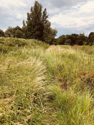
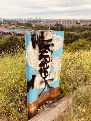
My aim now was to return to the eastern bank as soon as possible. I knew that the path along the western side of the river was tricky to follow, and given my greater confidence and experience now, I figured it was worth trying to stay the eastern course. I found my opportunity immediately after passing under the impressive brick viaduct carrying the Hainault Loop of the Central line, near the lesser used Roding Valley station. This cool, quiet spot remained a favourite for taggers and more creative street artists alike and I admired their work briefly before crossing the river onto a largely uncharted path. I was soon plunged into deep grass and tall swaying heads of cow parsley. There was really no path here at all - perhaps just the merest suggestion of a depression in the sea of green ahead of me. I pressed on, kicking up a cloud of pollen which I knew would cause me issues later. To my left, the boundary of a new development on the site of the former Tottenham Hotspur training ground snaked along the ridge of the valley. The housing here was part of the planning gain supporting the impressive Anderson Foundation school for children with Autistic Spectrum Disorder which occupied the site of the former training centre after the team's move to a purpose-built facility in Enfield in 2014. Pushing on further south, my makeshift path bordered a scrubby, wooded wasteland which had for almost a century provided the well-heeled Epping Forest District Council with a site for disposing of its detritus. Since the 1920s, parts of the site had provided a landfill dump, and a sizeable sewage works left strange concrete hardstandings amidst the trees and scrub. This was, strictly speaking, Metropolitan Green Belt land - but the presence of the final stretches of the motorway, and the permitted encroachment for school and housing gave it a distinct edgeland feel. I was walking the transition line here: wading through armpit deep grass and foliage, guessing at the path onwards and feeling incredibly remote from the playing fields and parkland on the western side of the river. Beneath me, the Roding snaked onwards towards the Thames, the path occasionally coming precariously close the edge of the gully which the river had worn over thousands of years of frequent flooding. I ignored the catch of hayfever in my throat and the irritation developing around my eyes: I'd walked plenty of trails in the past named for ephemeral flowers and natural features along their route, but as the only person foolish enough to tread this path today, I claimed the naming rights - this was The Antihistamine Trail.
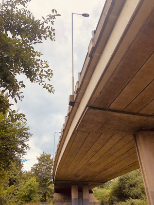
Rather unexpectedly the path widened and developed a stony surface, the mark of adoption by the local authority. The Roding Valley Way had reached this far along the east bank at least, and I soon found myself contemplating the other end of a bridge which had been securely locked out-of-bounds on my last visit despite being signposted towards the sometimes poorly marked footpath along the riverbank. I recalled sitting in the park on the other bank, applying sunscreen and recalculating a route which would take me the entire length of Ray Park before getting back to the river at Snakes Lane. This time I was able to follow the path I'd originally planned which from here to Chigwell Road was surfaced well enough that I passed someone pushing a pram in the humid air of the early afternoon. To the east, the baleful water tower of the former Claybury Asylum glowered over the treetops. Yet again, my walks began to entwine themselves into a network of knowledge: always selective, and sometimes false. The territory slowly gave up secrets and allowed me to link things together, my own travels dissolving into others' mythologies. The thin tongue of land between the river and the motorway dwindled to a narrow point, hemmed in by the built-up edges of Woodford encroaching from the west, and I was unceremoniously decanted onto the edge of the busy A113 as traffic hurtled under the motorway. I made the crossing with care, noting how alien traffic felt after the quiet isolation of the riverbank. I wasn't sorry to plunge back into the long grass for one last relatively wild stretch along the edge of the M11 as its carriageways began to divide to accommodate a ghost interchange. Here, the road would have ploughed on towards Islington, soaring over the North Circular and carving into the suburbs - but of course things didn't go quite to plan, leaving the motorway beached on the edge of the city. I soon found myself at my own junction: I could cross a narrow bridge to the west and find myself at a very familiar filling station, or turn east and walk an even better-trodden path between the motorway viaducts. I headed under the shadows of the concrete stilts - this was a special place, familiar from several walks which all seemed to converge on this dusty underpass. Walking among the huge, grey piers of the bridge felt like meeting old friends unexpectedly, and despite a pang of regret at leaving the river and the rough, challenging walk which had tested my resolve to get here, I was glad to be back on well-worn routes.
I've written several times before about the stretch of footpath which curves alongside the North Circular as it turns south towards the river. It was the closest I could walk when I was shadowing the broad, elevated road, upgraded to cope with the traffic spilling off the incomplete M11. It was also the path I'd taken when I'd walked along the Roding, and I realised now how deceptive it was. The gully of green-shaded water and the ranks of pylons which stalked the banks were corralled into a remarkably narrow strip of wasteland which was barely wide enough for the river and road, Indeed, it only accommodates them due to artificial straightening of the meanders in the course. I stepped up my pace, glad to have a good surface and childishly content to be kicking up clouds of Essex dust over my boots as I trudged onwards. I spied a familiar sight - a three-cornered pylon which shivered with multiple high-tension lines. It was strange and monolithic, standing in the deserted river valley largely unregarded by humankind despite their dependency on its steely purpose. The pylons here, like those which marched along the Lea Valley, felt like fellow travellers. They were ever-present, always more numerous than other walkers, and often felt far less threatening. I passed under the North Circular via the broad concrete subway which led to Redbridge Roundabout. I needed to detour here, passing under the angles of the junction to resurface on the south side of the A12 and double back. Rather sentimentally, I checked the short entrance road to Wanstead Pumping Station to see if the cat I'd met here a while back was still resident. If he was, he was sensibly sleeping in the cool shade somewhere in the overgrown garden of the lodge. I pressed on, turning aside in the backstreets of suburban Wanstead. Instead of my usual route to Ilford via the filthy litter-strewn backstreets beside the A406, today my aim was to head into Wanstead Park. The history of this substantial green space, now administered as part of Epping Forest by the City of London Corporation, is not entirely a happy one. A manor at Wanstead is recorded in the Domesday Book, and at the time of its acquisition by Sir Richard Child in 1703 a sizable house already stood on the site. Not imposing enough it seems for Child, who then set about building one of the first great mansions in the Palladian style to be seen in Britain which was completed by 1722. With Child created Viscount Castlemaine and married to Dorothy Glynne, heir to the Tylney family lands and fortunes, the impressive colonnade of Wanstead House provided a fitting seat for the now influential family. The inheritance of the Tylney properties was conditional on Child changing his family name, for which he obtained an act of Parliament in 1734. This set in chain a series of events which left, via generations without issue and the torturous laws of inheritance and title, the entire fortune in the hands of Catherine Tylney-Long. As the richest unmarried woman in the land, it is perhaps unsurprising that she was courted by the dissolute and caddish William Wellesley-Pole, nephew of the Duke of Wellington and already a notorious character.
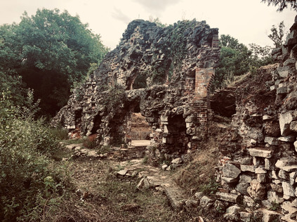
Catherine accepted his proposal, and to suit the conditions of inheritance Pole sought a royal license to change his name again, becoming the faintly ridiculous William Pole-Tylney-Long-Wellesley. He was thus elected to Parliament for St. Ives, and then for Wiltshire where the Tylney name remained influential. As an MP he was noted primarily for his extravagance rather than any great political acumen, and in 1814, Pole hosted an impossibly flamboyant fête at Wanstead House to celebrate Wellington's victory over Napoleon. The event was attended by numerous royals, including the Prince Regent and marked a high point in the houses' fortunes. The property and lands were held in a complex trust to protect the inheritance of Catherine's heirs, against which Pole raised an unwise mortgage to pay his spiralling debts. In 1822, the trustees stepped in to secure the situation - and with the land protected from sale for 1000 years, they liquidated every possible asset instead, auctioning the couple's personal property, demolishing Wanstead House and selling-off the building materials for a fraction of the cost of raising the great house. Catherine died from an intestinal complaint in 1825 having been abandoned by her husband, though letters to her sisters imply that her illness may have arisen from a venereal disease he had passed to her. Meanwhile, Pole remarried and returned to Parliament, though his second marriage was little more successful than his first. He continued to do his utmost to avoid accounting to his creditors, particularly seeking the custody of his son William with whom Catherine's remaining estate would rest. His uncle, the Duke of Wellington mounted a furious defence to prevent this, and Pole's petition was denied by the Court of Chancery. In contempt of court, Pole found himself committed briefly to the Fleet Prison. Retaining an interest in the estate until 1840, Pole oversaw the removal of many trees and destruction of original features of the gardens in an attempt to raise further funds, but he was finally prevented from further interference via a court injunction. The grounds of the house thus passed through the Wellesley line, with a portion sold to the Corporation of London in 1880. Wanstead Park subsequently opened in 1882, and has remained largely unaltered with the retention of remnants of the formal gardens designed by George London and improved by Humphrey Repton. In particular, I wanted to find the Grotto. Completed around 1760, this structure beside the ornamental waters in the grounds was not entirely a folly, providing a boathouse and repair facilities with a small lodge for the keeper. The building was decorated with shells, crystal, and mirrors under a domed ceiling which allowed in light from above. When the park opened to the public in 1882, tours could be arranged with the keeper - a Mr Puffem - and these were popular enough that the man received the honour of a humourous portrait in Punch magazine. In 1884 a fire, caused by overheating tar being used to repair a boat largely destroyed the grotto leaving only the facade standing. The structure was made safe and retained as a ruin, the bridge which formerly linked it to the eastern side of the water long since gone. Now the grotto sits safely behind a palisade fence, designed to prevent the inevitable insurance claim from someone clambering inexpertly over its ageing stonework. The lower area where boats could dock was uncovered by MoLAS archaeologists in 1998 but the structure was then left undisturbed behind its protective fence for some years, with vegetation soon taking hold and obscuring the remains from view. In 2011, a clearance operation revealed the grotto once again.
I explored the area around the Grotto for a while, enjoying being the only person around as the cloud finally passed over and illuminated the dried-up reed beds of the ornamental waterway. My route out of the park took me across the swaying grasses, aiming for a crossing between the Heronry Pond and the Perch Pond near a busy café. The earlier pollen exposure had begun to take its toll, and an oppressive headache was descending. I decided to tough it out for a while in the hope that I wouldn't have to cut short my plans. The next stretch would take me back onto the streets, among far more people than I'd seen all day and the thought wasn't welcome just now. I resisted the urge to remain in the park and to seek out the other hidden treasures which remained from Wanstead's spell as the centre of London society. Eventually, though I had to leave, taking the long, hot slog along sleepy Wanstead Park Avenue which led me to the eastern edge of Wanstead Flats. It was good to see the Flats recovering from the fire last summer, and from the brief walk alongside them, I could see foliage and insect life aplenty. Nature finds its way, it seems. I passed the impressive gatehouse of the City of London Cemetery where I took the southern fork in the road towards Manor Park, the route lined by mature trees and feeling rather cut-off from its urban surroundings. The remained of my walk would be a continuation of this route, often crossing my previous paths as I headed directly towards the Thames. Epping Forest finally gave way to London near Manor Park Station, sleepy in the afternoon heat as it faced the last tree-lined edge of the ancient woodland. A little further on I crossed Romford Road, a route I'd walked at the end of last year in a surprisingly memorable east-west perambulation. It was a shock to suddenly be surrounded by people again as I waited for the lights at the busy crossing. On the south-western corner of the crossroads, the grand brick and stone Earl of Essex with its imposing corner-turret remained empty and awaiting its conversion into the inevitable luxury dwellings, following a battle to retain it as an asset of community value. Beyond the crossroads, my route continued as High Street North, forming the spine along which the drawn-out town of East Ham spread its busy centre.
East Ham can claim origins in the Saxon settlement of Hamme which roughly constituted the dry land between Bow Creek and Barking Creek. Recorded as early as 958, the area was neither populous nor prosperous for the following nine centuries or so, presenting a marshy and inaccessible face to London. Transport thus defined modern East Ham - Victoria Dock opened in 1855 and the railway arrived in 1859. While in 1863 the area was still described as a 'scattered village' the following decades saw rapid urbanisation. As with other districts in the East End, the area was never affluent and the population largely worked in the docks or industry nearby. The pattern of terraced streets fanning out across the marshes remains familiar today, though the demographics have shifted dramatically. A County Borough since 1915 despite the protestations of Essex County Council, East Ham was absorbed into the London Borough of Newham in 1965, but by then was already a busy town centre in its own right. The area had weathered tremendous upheaval in its short tenure as a unit of government - relentless wartime bombing, rising poverty following deindustrialisation and the closure of the docks, and the tensions arising from successive waves of immigration. My walk along the High Street - on the face of it, not unlike any small British town centre - surprisingly reflected all of this history. Firstly, the mix of shops was a clear marker of the demographics: Halal butchers and fried chicken shops rubbed shoulders with Polish supermarkets and traditional Kosher stores. The street was still busy with traffic here, and the narrow pavements were a challenge to navigate, as I weaved dizzily between family groups stretched across the path, children lagging at the end of the line and teenagers texting furiously a few steps behind. The bright afternoon was charged with an urban energy and enriched with the smells of competing cuisines. I couldn't pass through quickly, even if I'd wanted to - the sheer press of people prevented it. South of East Ham Station, opened by the London Tilbury & Southend Railway in 1868, and served by the District Railway since 1905, the street is partly-pedestrianised and the local stores jostled for attention with branches of national outlets. Later in-fill development is evident here, corresponding chillingly with the sites on which high-explosive bombs fell. Proximity to the docks clearly drew the enemy closer here, and the curious mix of Victorian and modern was jarring when I cast my eyes above the shopfronts. Avoiding this part of town, the traffic took a spin to the west along Ron Leighton Way, named for the Labour MP for North East Newham who served from 1979 until his death in 1994, and who was a notable Eurosceptic .
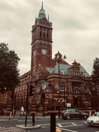
But these former marshy flatlands are home to others too: the dead cluster around East Ham. The old Jewish burial ground at Plashet was opened by the United Synagogue in 1896, and despite being closed for burials now sits just a narrow terrace of buildings away from the busy High Street. Further south, the vast East Ham Jewish Cemetery of 1919 was still operational, tucked away between the High Street and the line of the Northern Outfall Sewer. As London crept out across the marshes to the east, so new plots were needed for living and dead alike, and the alien east with its air and reputation already regarded as unwholesome had to carry the burden. Much of East Ham's heydey coincided with a golden age of municipalism, and the pride in the new Borough was reflected in the vast and ornate Town Hall completed in 1903 and still standing proudly at the crossing of High Street and Barking Road. The buildings ceased to be Council offices when the borough decamped to the Royal Docks, exchanging Edwardian brick for a huge glass-sided hangar overlooking London City Airport. While the Town Hall was being built and subsequently extended, the Borough was taking an enlightened approach to further new duties: appointing a permanent Fire Brigade, building new schools and dabbling in public housing. I paused to rest my aching feet and weary head at the corner of Central Park, a result of the early policy of the newly independent District to provide green spaces in each of its four wards. The grounds of Rancliffe House were acquired in 1896 for the laying out of a public park. Opened in 1898, the house was demolished a decade later and the park expanded to include an open-air swimming pool. The garden and art-deco Fist World War memorial at the corner entrance where I was seated followed in 1920, with the pool closing for good in 1923. Today, the circle of benches around the memorial was home to an extensive and expressive school of drinkers. As I stopped for refreshments and antihistamines I realised I'd strayed into someone else's drama: insults had been traded between benches, and tensions were rising. No-one seemed inclined or perhaps sober enough to make the first move, but catching the eye of an apparently uninvolved older drinker with a ruby-red nose and sad, drooping eyes, we tacitly agreed it was time to leave. He shambled off into the park, defying fences erected to safeguard the setting-up of an event, while I returned to the High Street. As I passed through the entrance gate, a proud survival from the earliest days of the park I heard the crash of glass and the yelp of pain which suggested that someone had finally managed to get their act together behind me. I didn't look back.
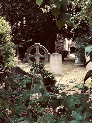
I was nearing the end of my walk now, but I didn't appreciate quite how suddenly it would come upon me. A consequence of the walking the arterial routes in this part of London is that while I appreciate how far things lie from the City, I often fail to appreciate their relative proximity to each other. Looking up I was surprised to see a sign advertising the junction with the A13 at Beckton Alp. I'd passed this way several times, and knew this junction well from other angles, usually arriving at the end of a long walk from elsewhere. I was nearing a spot I considered almost sacred on my walks, but I hadn't realised that this spot had a much longer history of worship. Tucked into a wooded corner where East Ham dissolved into the scrappy retail-park edges of Beckton stood St. Mary Magdalene Church, extant since around 1130 and built from stone including fragments of far older Roman remains. The low tower, a 13th century addition, was masked by ancient trees which clambered around the stones of a mossy, dark graveyard. It felt out-of-place here at the careening junction of major roads. Annexed to the church was East Ham Nature Reserve, an extension to the churchyard which made it one of the largest in London, and now a wilderness-like environment. Under the tangle of trees and through the bramble bushes, all appeared calm, green and humid. The fringes of the site had seen some speculative fly-tipping or drifting roadside rubbish but deeper into the plot the litter petered out. I stared deeper into the woodland, surprised by the sight of an old memorial at a queer angle. As I looked longer, more appeared: moss-covered and weather-worn, these old stones bucked from the ground in unsettling ways which suggested recent upheaval. I turned to check I was still on the busy road, with traffic queuing to swing out to coastal Essex or into London. It was, reassuringly or not given the strangeness of the times, still 2019 out here on the edge of Beckton. Somewhere ahead of me though, in an unmarked grave, lay William Stukeley, an antiquary and archaeologist who had made surveys of sites such as Stonehenge, Avebury and Rollright during the eighteenth century, largely founding the modern archaeological method. Stukeley's career was long and varied, taking in medicine and service as a clergyman, and his tendency to seek theories which placed ancient monuments and fossils in a Christian tradition as he grew older assured a devaluing of his work in later centuries. However, it's likely that Stukeley's annual expeditions on horseback to record these sites, and his evident zeal in discussing their history in eminent company has resulted in many of them surviving until now. His earlier research drew greatly on speculative ideas about Druidism and Egyptology, giving his work an almost mystical quality. Indeed it was hard not recall his description of Rollright Stones as I gazed across the gnarled trees of his resting place:
...a very noble, rustic, sight which could strike an odd terror upon the spectatorsWilliam Stukeley, an eighteenth-century antiquary - Stuart Piggott, 1950
I crossed the slip-road of the A13 and passed under its thundering concrete carriageways, emerging on the relatively quiet road into Beckton. Above me, the green flanks of Beckton Alp glowered over the flat marshland which was slowly disappearing under new development. It was impossible not to be drawn through the gateway, and to start the zig-zag climb to the peak. I wasn't alone today - it was a glorious afternoon with clear views across the estuary, and a group of young women had ascended just before me. I found the old gap in the fence mended, but a new opening had been twisted into the palisade nearby. It was a tighter squeeze, but I managed it without losing too much dignity and soon found my way to the peak. The group of youngsters lounged, laughing and chattered in the artificial bowl at the top of the hill, entirely ignoring me as I wandered the edge of the peak taking in the views. London unfolded: the city hazy and indistinct in the near distance. The dark ribbon of the A13 snaked back towards the city - walked, written and re-written but still somehow holding my attention. It was easy to understand Stukeley's instinct to romanticize and mythologise his findings from this vantage: while I'd made no novel discoveries on my climbs up here, I'd certainly found solace and sometimes unexpected resolution in the sweep of views and churn of winds. The view changed subtly as the sun shifted and clouds formed and drifted. Time seemed to slow. The regular pattern of terraces and patches of green parkland stretching away the foot of the hill signified the territory I'd just walked. I looked north, the tower at Claybury was just visible and beyond it a smudge of dark green signalled the distant forest and the valley which I'd navigated to reach this spot. Only the giggling and excited chatter behind me reminded me that I was still anchored to the vast sprawl of a city between me and the towers in the west. That the city could still surprise, delight and inspire me wasn't in doubt at all. Being back here, arriving from a different direction and viewing it in fresh context felt like a reward for the miles I'd covered. I started my descent to the DLR station, eager to make sense of today in writing.
You can find more pictures from the walk here.
Completing a project is something of an unfamiliar feeling here. It's rare I actually hold to a course for long enough to achieve any sort of goal, and even less common to feel that I've actually done justice to standards I've set myself. However, over the first five months of the year, as an act of either penance or thanksgiving depending on the overriding feeling at the time, I'd walked the five ordinal routes into London. So what to do now? I knew that my recording in writing of these routes was woefully behind - life without a perhaps somewhat extravagant laptop had curtailed my opportunities to bunker in the corner of a Costa Coffee and churn out words or retrospectively research places I'd found. But still, I needed to be out walking. June presented itself with a few options, but I had a hankering to get back out to the east of the city. I hadn't ventured east of the A1 since a fateful walk in December where I'd set out not really knowing where I'd head. So today, perhaps I'd try the same basic approach? I knew that I wanted to find evidence of a couple of streams in the east that hadn't figured in my treks before, and I had a rough idea of a way to combine them into a longer trip. I also had a hunch that I'd end up at the Museum of London Docklands at some point. I decided to throw all of this into an unplanned recipe for a day which should, after all, have been a celebration of freedom from rules or methods. This was probably not the soundest basis for planning a walk which needed to function as my treasured monthly excursion, but nonetheless, I set off into the suburbs.
I was one of very few passengers to alight at Gidea Park. The brand new train I stepped from was intended to have sped me under the city, from Paddington directly here - but its purpose was humbled by the continued delay to Crossrail. Instead, it droned away east, mission foreshortened, leaving me on a quiet platform under unexpectedly leaden skies. I set off out of the station, aiming for the southern exit onto Station Road. My route took me further east along the railway fringe, passing south of the fan of sidings which housed inactive commuter trains between the peaks. I crossed Upper Brentwood Road which led north towards Gallows Corner, passing through suburbs which now covered the grounds of Hare Hall, a Palladian mansion completed in 1770 for John A Wallinger. The building, now much encroached upon by housing, has served as the Royal Liberty School since 1921 and has the distinction of being the first British school to install a computer - an Elliott 903 operated by paper tape, purchased in 1965. Beyond the junction, I headed along Squirrels Heath Lane. This name appears almost lost from the map aside from this lane and the adjoining road which stretched east to the administrative limit of London. Locally, it appears that Ardleigh Green is the preferred nomenclature, with its connotations of sleepy Essex village rather than the dangers of a bleak, rodent-plagued wasteland. Ironically perhaps, the hamlet from which this new name has slowly crept west was once Hardley Green, which is perhaps more descriptive of the sunbaked concrete and brick vista I found today. Nevertheless, near the patriotically proud point blocks of Elvet Road (Victoria, Elizabeth, Edinburgh, Mountbatten) I finally found my first target: from the edge of the David Lloyd leisure complex, the tiny Ravensbourne trickled in its narrow culvert.
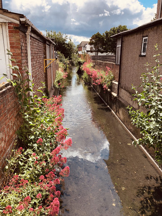
There are two Ravensbourne streams in London - and it is fair to say that this is the lesser in stature. Rising near Gallows Corner, and running between the backs of suburban streets, it makes a first accessible appearance here among the comfortably appointed homes of Havering. While its southern namesake strikes out across the wild spaces of Bromley Common, this little stalwart stream has done well to avoid enclosure during development - perhaps only saved by the need for surface drainage in order to build on the uncommonly flat floodplain here. My first sighting was inconclusive: a burst of greenery between two houses, and a tell-tale brick wall synchronising with a notable dip in the carriageway. It was going to be a day for this kind of evidence - stolen glimpses of sluggish water, traced by contour and instinct. I turned back and headed south along Northumberland Avenue, a long street of impressive detached properties which shadowed the river. Behind its back gardens was Haynes Park, for which the Ravensbourne formed the western perimeter - but there was no clear entrance from the north. Instead, I entered midway along the park's western side via a wide driveway surrounded by green municipal railings. The twin towers of Haynes Park Court overshadowed the park entrance, two of the smattering of tall blocks in an expanse of otherwise low-rise housing. Designed by Thompson and Whitehead who don't appear to have ventured into this type of work often, these blocks were erected for the rather prosaically named Multistorey Housing Association in 1966. They slumbered on, decaying into a rather grim state until recent refurbishment of the gloomy galleries and stairways. It's hard to say whether this was a result of their one grim moment of infamy when a young man plunged from the ninth floor of one of the blocks in 2012. I found few other references to the work of Thompson and Whitehead save for a tiny, modernist church in nearby Becontree dedicated to St. Cedd - bishop of the East Saxons and patron of Essex.
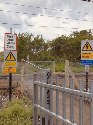
I let the river make the going, doglegging through the streets along its subtle contour line. After spying it passing under a fine little concrete balustraded bridge, I tracked the course via the appropriately named Brooklands Gardens, finding the Ravensbourne constrained in a deep culvert where Lewis Road inexplicable mutated into Warrington Gardens. Presumably, the river had at some point marked the boundary of developments here. I found it again in a marked depression on Hillview Avenue, behind a tidy brick wall with a well-secured metal access gate. I now had to pass a manmade barrier in the form of the Romford to Upminster railway line. This tiny link between the lines from Liverpool Street and Fenchurch Street survived against the odds, now part of the Overground network and served by a train shuttling back and forth via the single intermediate station at nearby Emerson Park. The line was unusual in being crossed by few bridges, and featuring instead a number of at-grade foot crossings. It was one of these I was aiming for now, via a surprisingly long diversion to the west and along a rutted back-lane behind homes and garages. During the cutting of the line in 1892 an unusual geology was uncovered, with sand and gravel overlying a thick bed of boulder clay. This signified the most southerly extent of the Anglian ice sheet during the longest and fiercest ice age of the Pleistocene era. The upper layers of sand had traveled from the Midlands, deposited here on the edge of the Ingrebourne valley some 450,000 years ago. The residents of South Hornchurch crossed the railway line with due care, seeming largely unawed by the great history of the clay dust their feet kicked up at the edge of the ballast. South of the railway I turned back east, finding the river again at its slewed crossing of Osborne Road before taking a turn into the long avenue of Lyndhurst Drive. The river was out-of-bounds again, ploughing between back gardens and then bordering allotments on the site of the former great house of Grey Towers. Built in 1876 for Lieutenant-Colonel Henry Holmes, the owner of the Hornchurch Brewery, the crenelated mansion passed into military ownership on the owner's death in 1914. Used initially as a depot and base for the 23rd Royal Fusiliers - the Sportsman's Regiment - from the summer of 1916 it became the New Zealand Convalescent Hospital with 1500 beds available for injured troops returning from the front line. Increasing casualties saw it expand by a further 1000 beds before it closed in 1919, with the last troops departing for New Zealand in February 1920. Pressure on land for suburban growth saw Grey Towers demolished in 1931. A nearby neighbour, the much older and somewhat grander Langtons - also built for a brewing family - was gifted to Hornchurch Urban District Council around the same time, but survived due to a covenant on the gift which required it to be used for municipal purposes. Langtons survives as the local Register Office and was briefly at the centre of a High Court case where its license lapsed and the legality of 193 marriages was placed in doubt. Meanwhile, no trace remains of Grey Towers, save for the name of a new development of houses near the allotments.
A crossing of the busy A124 caused me to re-orient myself: I'd passed this way before, and recalled the awkward bend at the bottom of a dip where I had to make a swift crossing of the busy east-west route at the venerable Ravens Bridge. Ahead of me, the broad green space of Harrow Lodge Park opened out, with the river and path sticking to the eastern edge and skirting the carefully prepared cricket pitch. The huge park was laid out on land donated by Richard Costain and Sons during their construction of Elm Park Garden City and occupies the site of the 16th-century manor house of Maylards. The park was pressed into use as a market garden during World War II, with the decommissioned fields redeveloped as leisure facilities after hostilities ceased. Around the same time, a comprehensive redesign of the park took place with the Ravensbourne dammed between 1954 and 1956 to form a large boating lake. I followed the river to its outfall on the lake, noting the sudden rise in the wind when I stepped away from the treeline. The lake surface was serrated with waves, the park largely quiet aside from the cluster of activity around the café. It made for pleasant walking, crossing the lake via a bridge at the centre and heading into the wilder part of the park to the north rather than following the path. In the event, all routes led to Upper Rainham Road and another familiar spot from my walk along the Beam River. I crossed carefully, heading along The Chase - a route I'd abandoned on my last walk as too treacherously busy with four-wheel drive vehicles conveying the local young women to an equestrian centre. This time I decided to persevere, swiftly finding the shameful spot where I'd crashed out of the woods beside the Beam and turned aside, cowed by the unexpectedly rural aspect of the zone I'd stumbled into. A little way to the south, the Ravensbourne trickled into the Beam, much reduced in feeding the great lake in Harrow Lodge Park. I followed the lane west, passing through the yard of the Eastminster School of Riding and into a narrow lane, overhung by trees. At some point, soon after passing the heavily fly-tipped opening of the path I felt like I'd passed out of suburban London entirely and into the lost farmland landscape of West Essex.
My route through Eastbrookend Country Park was perhaps the most pleasant part of the transition between the two rivers I planned to walk today. A relatively rural stretch between the park and neighbouring cemetery opened into an insalubrious lane frequented by cars with their engines running, edgy van drivers taking power naps and a cluster of Deliveroo staff holding some sort of clandestine workers' council. I soon met the curve of Dagenham Road which led into the edges of Becontree. The crossing of the great estate was hard going: the pavement tough on the feet and the strange monotony of the expansive sprawl of houses stretching seemingly forever. I found a shop to purchase lunch and ate on the hoof, not wanting to delay here. I struck a northwesterly path, aiming to cut across the central spine of Valence Avenue and to turn aside at Bennett's Castle Lane. My target was South Park on the edge of Ilford which felt impossibly distant as I slogged along the dry, windswept pavements walking into the gale. I felt stretched and tired, and the walk felt purposeless and vague. I briefly crossed my own path once again at the entrance to Goodmayes Park where the little Mayes Brook sputtered along unseen under the road. Compared to the rivulets I was tracking today, the brook felt like a more substantial target and I again began to doubt my purpose. Undeterred I stumbled on through the eerily homogenous bungalow-scape of the Mayfields Conservation Area, dumping my plastic bottle into one of the multitudes of recycling canisters on each identical driveway, surely a proliferation not expected when the area was designated in 1991 and the scourge of satellite 'dishes' was the borough's main concern? I finally emerged onto South Park Drive, realising that the entrances to the park were at the north and south extremities, and arriving squarely between the two I would need to walk the length of the park to enter. I cut my losses and headed south, tiny tantalising glimpses of the lake formed by Loxford Water inside the attractive green space.
It's unclear where Loxford Water rises now, with the coming of the Great Eastern Railway and urbanisation of the area much altering the local geography. It flows into the ornamental lake in the park as the Seven Kings Water, a stream which was itself diverted to run along the northern side of Green Lane at some point prior to the late 19th century, rather than following the ancient line of Water Lane which was likely its original course. Above the confluence there appear to have been two streams, with the Loxford Water rising somewhere in the brickfields near Ilford Cemetary in a spot once known as Sam's Green. In any case, my first glimpse was of a narrow, buddleia lined channel between the homes on South Park Terrace. Unusually, as it cut across the pattern of streets - all aspirationally named for leafy Surrey suburbs - it appeared that the locals had embraced the stream. It was clean, free from dumped litter for the most part, and felt part of the urban geography of the suburb which bore its name. I tracked it south, dipping into the side-roads to steal glimpses as it converged on the main road, finally running in a deep, steep-sided concrete channel on the western flank of the street. I calculated that if the Seven Kings Water had in fact followed Water Lane it would have had joined the Loxford Water somewhere under the mini-roundabout on Dawlish Drive. I surveyed the scene - it all felt somewhat unlikely. The rivulet had gone native and now belonged to the suburbs, not the ancient countryside. I walked alongside it for as far as I could, pointing my camera through a fence at the point where it swung west behind Loxford Social Club, towards an impressive new school building. I continued south to the entrance to Barking Park where I could again walk alongside the Loxford Water as it edged around the long lake created from its flow. The park opened in 1898, the first such park to be operated by Barking Urban District Council, and it was widely regarded as the finest in East London at the time. The long lake was a major feature from the outset, once plied by a paddle steamer called Phoenix II which carried visitors almost the entire length of the park. The busy lido, closed since 1988 is now a 'splash park'. I tried to walk along the narrow sliver of land between the stream and the lake, but it soon proved impossible and I returned to the path around the southern shore of the lake. I found a bench somewhat sheltered from the wind and rested awhile. The park was busy with walkers, hunched against the unexpected windchill on an otherwise bright summer afternoon. I ruminated on my walk, figuring that perhaps it hadn't been entirely as dull as I worried it may be. I hoisted my bag for the last stretch of the walk, following the lake to the gate and taking a final look at Loxford Water under the bridge before it disappeared into a final culvert between industrial units which led to the banks of the River Roding. I noticed it was possible that I could see it one last time closer to the confluence, but I decided to turn aside and head for the station. There were other rivers that needed my attention now.
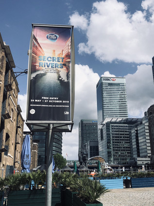
The train made the familiar, but always exhilarating journey across the rooftop-level viaducts of the East End, depositing me on the narrow platform at Limehouse. The station was laid out like an unearthed ancient arrowhead pointing at the city, formed by the convergence of DLR and railway. Feet tired, I took the lazy option, doubling back a few stops on the DLR to get to Canary Wharf. It seemed only fitting to approach the Museum of London Docklands via water, so I descended from the platforms to the dockside as soon as I could. The Canary Wharf estate had finally pulled off the ultimate regeneration trick: I remember weekend visits here years ago, being alone with the security guards in a deserted cityscape, but now the plazas and promenades were filled with people. This city outside the walls which had once been solely a workplace, abandoned outside office hours, now drew in an around-the-clock leisure-seeking crowd too. I navigated out of the busy, exclusive shopping centre and onto the waterside, crossing a bridge that afforded an excellent view of the inert Crossrail station currently functioning as an expensive roof-garden. The sun glinted from the surrounding towers, reflecting a cloud-flecked sky back at the dock surface. Across the bridge, in a Georgian sugar warehouse, the museum housed its latest exhibit: Secret Rivers. I'd vacillated about attending this event for some time, reasoning that I might be disappointed by something which skated too blithely over this topic which had occupied my thinking for so many years. Or perhaps it would take a prosaic tack, denying the rivers their ancient spiritual significance and talking up their industrial heritage over all else? I was relieved though to get over my vanity and visit because it turned out to be well-judged and balanced. The symbolic significance of London's lesser-known rivers was covered well, as was their gradual transition from rural streams to working rivers, and finally to shamefully culverted sewers. Some of the most interesting aspects of the exhibition centred on the rehabilitation of the rivers: by half-serious pressure groups, visual and audio artists, and of course in literature. A wall of books inspired by the rivers showed a long tradition of influence, and well described some parts of my own oft-repeated pathway to the banks of these streams. Not least, on one broad white wall, a quote from Aiden Andrew Dun describing the River Fleet:
The Fleet is a secret ditch, the kingdom of typhoid, a conduit of bad airVale Royal - Aiden Andrew Dun, 1995
The museum had done a fine job of pulling together the secular and sacred and had wrangled the attention of even the oddest cranks and freaks among us river-walkers away from our dubious texts and divining rods for now at least.
Perhaps the most arresting part of the display was a wall-sized map of the Thames estuary showing the tributaries of the river. I politely waited my turn for close inspection while a young family pored over South London. "You mean there's a river under our house!" a boy exclaimed to his amused mother, stabbing a pudgy finger at the convoluted line of the Effra. He was utterly captivated by the idea of a world under this one, entranced by something dark and presently formless, yet open to the imagination. I saw the spark of wonder which I'd found somewhat later than him - and I was thrilled to see it kindling the kind of excitement I still felt when I tramped about the suburbs on the trail of a rivulet or gully largely forgotten by most locals. I finally got my turn at the map and realised with a mixture of amusement and surprise that the rivers I'd walked today weren't there. Perhaps in my own childlike flight, I'd imagined them too? I set off west, towards the City, planning a call at the churchyard of St. Anne's in Limehouse where I knew a certain pyramid would be anchoring me to the earth, just like always. My history of London might be borrowed, butchered and misappropriated from all kinds of places, but that I could still lose myself here was very, very important.
A gallery of pictures from the walk and the exhibition are here.
The bus deposited me on the southern side of a broad dual-carriageway with a generous but unbarriered concrete median. The road was eerily silent. I paused, wondering quite where I was and feeling the familiar tingle of anxiety at not quite knowing what I'd let myself in for. Suddenly the sky tore open above me with the blistering sound of jet engines bringing a Boeing 747 to a shuddering, gravity-defying safe landing after a transatlantic crossing. I'd walked in the flight path before, but this was unlike anything I'd experienced. Silent again, I turned east, against my better judgement, in search of a place to start walking. As is so often the case, a river provided the boundary: The Duke of Northumberland's River - formerly the Isleworth Mill Stream - ploughed a straight furrow under the road, separating the village of Longford from the ancient parish of Harmondsworth. A single car passed by. I wondered if there was some sort of incident or road closure, but it seemed that beyond Heathrow the road dwindled in importance. I was able to cross unassailed, pausing to take a picture back west. Looking along the asphalt, the long walk ahead of me seemed almost impossible from here at the edge of London. Strictly speaking, the boundary lay a few yards further to the west where the River Colne passed beneath the A4, but this spot somehow felt right. Records indicate that this watercourse was being worked on in 1530, bringing the waters of the Colne to drive mills and irrigate the fast-draining farmland on the Duke's estate. It is also likely that the labourers were not digging a new ditch, but refettling an already extant channel. For centuries humanity had tinkered with this landscape, reshaping and redefining it. Here on the edge of one of the zones of London most overwritten by human activity but in many ways least human in scale, I'd start walking west along the ancient road from my homeland to London. Another aircraft shredded the cloud-cover, overwhelming my already music-battered hearing. I started walking...
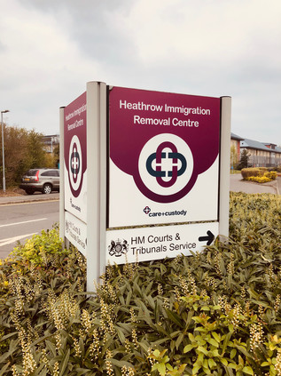
The road was still uncommonly quiet and, while initially shocking in its intensity, the regular rhythm of landing aircraft soon became reassuring background noise softened by the warm dead air of a Spring morning. I was, technically at least, in Harmondsworth. The Great West Road entered London at the historic crossing of the Colne in Longford and then turned aside from a long extant route which ran somewhat to the north, instead hugging the perimeter of the airport. The tiny remaining hamlet with its historic barn - the Cathedral of Middlesex - lay a little way along the older route. Unlike much of the parish it had escaped being devoured by the airport - so far - and existed in the midst of edgeland hotels, sprawling car parks and patches of scrubby, rough grass too blighted by noise and pollution to develop - but too much of an asset to dispose of. The only inkling of civilisation I found here was possibly a signal of just how uncivilised Britain can be: the twin Immigration Removal Centres, Colnbrook and Harmondsworth. Lying at the end of a snaking PFI-primped driveway, the nondescript blocks could have been insurance offices or utility company call-centres. But they weren't. These blocks housed people who were awaiting removal from the UK: perhaps because they had overstayed a Visa, committed a crime whilst in the country or in the most hand-wringingly sad cases, where some error of judgement or fact had put rules before reason. I had form with the UK Visas and Immigration department - and I had to say they'd always been polite, efficient and decent to me and my family. But we were paying for the premium service: fronting up for an on-the-day determination to prevent the gut-wrenching months of uncertain waiting. Beyond the moderately better customer experience, we were gatewayed into the same system and surfed the same challenges of the hostile environment. A word wrong here, an item of evidence misplaced or misdated and... Well, the situation was too much to contemplate - and the feeling of lingering outside these mystifying but compelling compounds made my bones ache with horror. I tried to move on, to turn my face to the east and head for the City, but I needed a picture to prove to myself that I'd been here. I snapped the shot and turned away, hurrying along the pavement. A little further on a UK Immigration Enforcement van passed me at low speed, u-turned zippily around the central reservation and came back for another pass. I pulled my hat brim lower and put my head down into the walk. Heathrow shimmered in the heat-haze of jet exhausts across the street: planes taxied and screeched into steep take-off. The van returned, pulling across my path at the entrance to an elaborate Chinese restaurant. Like all exchanges with the Home Office, it was quick, efficient and polite. The threat was implied, never explicit. They ruled out nefarious purpose by check-listed category: Did I have business at the centre as a visitor? Was I concerned about someone being held there? Was I secure in my own status in the UK? No, I wasn't, but it was more to do with botched Brexit and bad diplomacy than the Immigration Act. They let me move along, careful not to mention the camera or the picture, knowing they had little jurisdiction. Rattled but oddly vitalised by this unexpected encounter, I continued walking. Such events seem almost passé now - the urban wanderer disentitled from his or her (but usually, of course, his) rights in some liminal area where justice and access were not guaranteed. Whether it was the ubiquitous Ikea carpark or a Home Office Detention Centre, the truth was we sought the thrill of a challenge - even if the encounter would be fraught with misunderstanding and excruciatingly difficult to manage, given British sensibilities.
Despite the careful ministrations of the Home Office, it was actually rather hard to determine if this was still Britain at all. The landscape here was generic airport: low-rise hotel blocks crept along the road, filling the gaps left by aeronautical businesses which clustered around the perimeter road seeking an address as close to Heathrow as practically possible. The fence was endless, and I was aware of an internal system of heavily-trafficked roads within the Airport which paralleled my own, comparatively quiet route. Yawning pre-flight families stretched their legs via a turn around the hotel carparks. They had nothing to do before heading into the maelstrom of retail and restaurants, but instinctively wanted to put off their airside incarceration. Staying near the hotel had no doubt seemed like an ideal proposition, but it meant filling those long, dead hours before check-in opened with something other than a frenzied dash to Heathrow. Some of them sauntered along the A4, nonchalantly hopping the barrier to cross to the Starbucks franchise which nestled against the fence. Others sat on luggage, staring at the ground and waiting for the shuttle-bus which would whirl them around the perimeter and slowly towards the Central Bus Station, like the last trickle of a draining sink. Slowly, civilisation returned in the form of a string of semi-detached houses which invariably proxied a return to the urban on all of my walks in this series. Here, directly under the flight path life continued despite the desolate, lost acres of secured tarmac and grass nearby. Indeed, tucked inside the secure perimeter, just feet from the teeming tunnel which funnelled passengers into the airport, an inconspicuous and much-ignored cannon barrel stood as a monument to General William Roy's Anglo-French survey, a superbly accurate mapping exercise which commenced with a line from here south towards Kingston, effectively launching the Ordnance Survey. Roy didn't live to see his scientific advances cover the whole of the British Isles, but the scale of his achievement was certainly celebrated in his lifetime. In 1793 he was awarded the Copley medal by the Royal Society with the simple citation: "For his Measurement of a Base on Hounslow Heath".
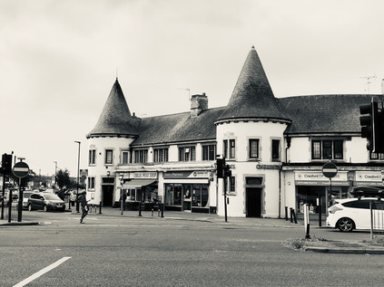
Again, a river marked the transition: this time the Crane, this stretch still unwalked after abandoning my attempt last summer. It passed under a stone-balustraded bridge inscribed with the arms of Middlesex having wound its convoluted way here from Harrow as the Yeading Brook. My memory of Cranford wasn't challenged by a new approach from the west: it remained a tired and decrepit place. The quiet and rather dull little High Street turned north, heading for the bus stop where I'd bailed out last time, while the main focus of the village had shifted here to run along the Bath Road. The parades of shops and homes, largely dating from the 1930s had intermittently been demolished to provide space for barcode-fronted hotel blocks - maybe signifying the last possible zone where a business could legitimately include 'Heathrow' in its name perhaps? At the heart of Cranford, or at least what passed for it now, the crossroads at Berkeley Parade spanned the road. Each southern corner featured a short run of local shops, adorned with a mock gatehouse bearing twin, chateau-like conical towers. Under these oddities the usual suspects traded: hair and beauty, betting shop, Halal butcher, Kebab takeaway. Between the arms of the parade, a filling station had been ingeniously nestled into the traffic island, but had now become an inexplicably 'American' car wash. On the northwestern corner of the junction, the Berkeley Arms Hotel mimicked the towers and turrets, taking them up a notch towards the grandiose, despite now functioning as an adjunct to the massive new Doubletree by Hilton next door. The final corner was left to a scrap of grass, untouched by a housing development which had crept towards the crossroads but given up short. Perhaps this unkempt litter-trap was a vestige of the cherry orchards which once edged down to the Crane before the building boom of the interwar years? Maybe this was the only authentic spot to be found at this weirdly deceptive way-station on the Great West Road.
I wasn't sorry to leave Cranford, despite an acute awareness of my need to return at some point to complete the navigation of the River Crane. Departure also necessitated a crossing of the interminably congested and treacherous 'Parkway'. This relentlessly busy north-south route had grown in importance beyond its design, cutting off a useful corner between Heathrow and the M4 and linking to the northwestern suburbs more directly than any of the more major routes. This fistula between the quadrants was a remnant of the Ringways plan, but benefited from none of the associated engineering - thus it was a channel of broken glass and decaying memorial flowers. There was no pedestrian provision for the trajectory I was taking. A subway portal leading to the south-western corner of the roundabout was the only viable option for walkers. Instead I had to chance the ebb-and-flow of the traffic, negotiating with drivers slowing for the turn, or speeding away from it. Waggoners Roundabout was named for the Jolly Waggoner, a long-standing staging post on the road out of London which was now an Indian restaurant, along with an opportunistic and fairly basic offer of rooms for the confused traveller taken in by their website's 'near Heathrow' or 'minutes to Twickenham stadium' spiel. Neither of these claims, ambiguous and inaccurate as they were, compared to the bare-faced audacity of claiming that it is well-situated for 'the best of Hounslow'. A trickle of guests left for their long circuit to the airport entrance or today's Rugby international, shoulders slumped, composing their TripAdvisor reviews as they rubbed sleepless eyes and worried about making their flights. Beyond this forlorn spot, the northern flank of the A4 rather suddenly gave way to farmland, save for an impromptu airport parking concern which had set up camp on the fringe of the field. While my route would pass a few streets from areas of parkland, this was my last chance to get close to nature from the pavement so I savoured it carefully, This was a tiny corner of the vast tract of Hounslow Heath which once straddled the routes into London from the south and west, providing campsites for armies and cover for cutpurses since time immemorial. Now, the suburbs had swept in like a tide, leaving a litter of low-rise former council houses in their wake. But these ancient arterial routes are defined by their wayside taverns, and at the next junction the textbook transformation had taken place: the huge mock-tudor 1920s Traveller's Friend with its towering brick chimneys and multiple gables had morphed into a McDonalds.
I've written before about these sprawling interwar public houses along the routes into London, perhaps incorrectly describing them as 'roadhouses'. There certainly are many such places on the trunk roads of Britain, but these earlier arrivals on the scene are more properly termed 'improved pubs'. As the era of motoring for leisure and business dawned and the UK road network began to expand into something close to its current shape, many tiny and old-fashioned drinking establishments along the way received huge investment from the brewing industry. This was a conscious attempt to lend some respectability to drinking places, adding restaurants, opening up the lounge bar and displaying a grudging acceptance of men and women drinking together. However, there was always something a little louche about these places - located out-of-town, often in suburbs which hadn't yet quite solidified around them. They were places not to be seen, where exotic entertainment thrived and where the serious business of boozing played second fiddle - a shift which would continue as the century wore on. In some ways they led successive waves of suburban architectural style: in the 1920s 'tudorbethan' was popularised by the rebuilding of old inns in the style of The Traveller's Friend here in Hounslow. Later, as the roadhouses emerged along the new dual-carriageways which scythed across once open country where there were no older pubs to improve, it was in the Moderne style: smooth concrete and steel for a new, streamlined world. Here at Henlys Roundabout, roads both old and new converged: my route in from the west met the end of the A30 - the Great South West Road which began its long journey to Exeter and Land's End, remaining remarkably faithful to the ancient tracks recorded by John Ogilby - His Majesty's Cosmographer and Geographic Printer - in the 1675 Britannia Atlas. The old road to London continued ahead taking a straighter route than mine, but snarling and stalling into Hounslow's town centre. Instead I struck out along the new Great West Road, built in 1925 along a straight alignment through largely open countryside. The road east still felt broad, modern and optimistic, despite the presence of towering digital billboards hired by an organisation called 'Brexit Express', urging drivers to 'Take Back Control'. Brexit haunted these approaches to London. It was impossible to escape the impending sense of its coming, but like a traffic jam on the A4 no-one quite knew when it would arrive or what we'd find at the end of it.
Suburbia had encroached on the stretch of straight new road which I was now walking, enclosing it in a halo of comforting banality after the nerve-jangling junction crossings I'd navigated. This area between Heston and Hounslow was slow to develop, with the Hounslow & Metropolitan Railway passing by from 1883 but taking a deep swing to the south, and leaving the pattern of tiny villages and lanes here until well into the last years of the 19th century. The tiny hamlets of Sutton and Lampton were removed from the map gradually, but surely. Their names captured and surviving only in side-streets, parks and schools. The clusters of shops around the former village centers had in each case become a hotel - Sutton had the Master Robert, a fine old 1930s pile, at least until its demolition for a much debated new Ibis Styles. Meanwhile the imposing, grey slab of the Park Grand rose over the road at Lampton, claiming only moderately dishonestly to be ideally situated for Heathrow. It was in the same general quadrant of the map of course, but this could be a world away from the security cordons and perimeter roads of the airport, which felt like they were in another territory entirely. The pavement stretched ahead, the horizon only broken by the curious concrete totem atop Osterley Station. The station building was reconstructed abbutting the Great West Road in 1934, replacing the former Osterley & Spring Grove further to the east, near to the grand Thornbury House and little else. The brick tower and concrete spike looked like a lightning-rod drawing the energy of those interwar years of municipalism. It was the work of Stanley Heaps - who became Chief Architect for the Underground on the early death of Leslie Green in 1908. Heaps' presided over the introduction of escalators to stations from 1911, designing the first stations specifically constructed to use them by adapting the archetypal two-storey oxblood terracotta tiled design which Green had perfected. Heaps' tenure also overlapped with the great Charles Holden whose streamlined, modernist designs for the City & South London Railway extension (now the Northern Line) had been selected in preference to his own rural pavillion-style buildings by Frank Pick. While Holden was commissioned to work on many of the numerous new stations constructed during the 1930s, Heaps tended to take on the minor projects and lesser-used extremities of of the network. Hence, his futuristic and imposing building at Osterley soars over the low-rise suburb, more like a modern estate church than a transport nexus and with a knowing nod to Holden's style. The railway was extended to new stations serving the growing town of Hounslow and eventually to Heathrow Airport, but Osterley remained a rather drab and quiet place. Beside the station was an abandoned bridge crossing over the tracks but heading in completely the wrong direction, wide enough for a line of traffic but grassed over with access only on foot. A glance at a historic map had this crossing here from the outset in the 1880s: a sturdy and remarkably well-made structure carrying only a farm track between divided lots of land. It survived rather miraculously beside the Underground station and the shuddering traffic - a bridge to nowhere surrounded by modern suburbs and hemmed in by busy railways and roads.
In so far as Osterley was a real place, it didn't extend far beyond its eponymous Underground connection. Away from the road, removed from the suburban sprawl in a large tract of parkland stood Osterley Park, built for banker Sir Thomas Gresham in the 1570s following his purchase of the manor of Osterley, this impressive Elizabethan pile was one of a ring of fine manor houses which would once have felt remote from London. The brick tower of the station felt like a modern, single-fingered salute to the great city dynasties, and beyond it the Great West Road returned to suburban mundanity. Comfortable villas rested behind service roads, cycleways and barely-used pavements, some of their stones cracked by the swift turn of vehicles onto driveways. The mock-tudor theme was carried into the Osterley Park Hotel, a sprawling while building with just too much of a hint of Fawlty Towers about it to be entirely convincing. The carpark was surrounded by the kind of low-rise motel blocks which belonged on a Midwestern Interstate. This place shared all their downtrodden sleaze and none of the romance of the road. It was hard to forget at this junction, that the Great West Road was once the height of modernity - a hopeful, gleaming stretch of pristine factories stretching towards London and manufacturing the newest things: wirelesses, disposable razors, processed foods. The white-heat of early-20th century progress had played out along The Golden Mile, before being cruelly cut short by World War II and the following austere years where consumption was regulated, and luxury impossible. The change in tone began in earnest at Gillette Corner, where Syon Lane crossed the road at an oblique angle, allowing a wide sweep of land to wedge up against the road. Here, in dark brick and great sweeps of steel-framed glass, Sir Banister Fletcher Jr's imposing and vast Gillette Building glowered across the cement plain of the suburbs. Atop its stacked, churchlike tower a copper cap and an illuminated clock still radiated progress and modernism despite the decline of industry in the surrounding area. Now at risk of redevelopment as a business park and residential zone, the building is at least listed. Other examples of classic commercial and industrial architecture hadn't fared so well here. Not least the once equally mighty Firestone Building, designed by Wallis, Gilbert and Partners and finished by 1928 and modelled on an Egyptian temple. The style was then rather jauntily known as 'jazz moderne' but later more familiar as Art Deco. The Firestone Company ceased using the site in 1979, and the area was threatened with dereliction. Minded to save the impressive building, Michael Hesletine at that time Environment Minister, intended to list it. A tip-off to the developer, commonly thought to be from within his department, saw the bulldozers move in over the August Bank Holiday weekend of 1980, and the building was gone save for the striking perimeter wall topped with decorative lamps. In some senses, this destructive and needless loss saved much Interwar architecture, with Heseltine swiftly moving to protect the Hoover factory and Battersea Power Station from demolition. But the loss was great, and the Golden Mile still bears the scars. The roll-call of consumer products and technological marvels which were once manufactured here seems mundane now, but would have been groundbreakingly futuristic: cosmetics and toothpaste, radios and gyroscopes, cars and fire-extinguishers. The statue of a sylph-like diver wasn't replicated atop Jantzen House, the inert modern residential block nearby named to memorialise the knitting mill, and the aroma of baking and hot sugar no longer emanated from the biscuit factory. In fact, on a windy Saturday the Great West Road was eerily quiet. A few cars nosed carefully into the traffic as they exited the Syon Clinic, a private healthcare facility which now occupied the former Coty factory, and the turning-lane bore the tyre-marks of heroic spins across three carriageways of traffic to access the HQ of Sky TV. The road was quiet though, its best years long behind it and a faded glamour only barely showing through the grimy, smoked glass fronts of modern offices.
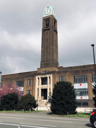
An almost imperceptible dip in the road heralded the crossing of the River Brent. I had passed under this bridge on my last visit, almost entirely unaware of the road above except for its reflection in the flanks of the Glaxo SmithKline offices which snaked along the river as it plodded sluggishly towards the Thames. There was equally little trace of the former GWR railway line which crossed above the road here on its course towards Brentford Dock - an ill-starred and poorly used line which has remarkably survived for carriage of aggregates and refuse, now curtailed to a terminal north of the A4. Crossing the Brent felt like a reconnection, a sense of tying what had been a disconcerting and alien walk so far into my existing map of London. I was grateful to the persistent river for the familiarity and the context, as the Great West Road was a disorienting companion: modern but faded, broad and fast-flowing but now rather strangely empty of traffic. The reason for this quieter passage was nearby: curving in from the northwest following a crossing of Osterley Park which would surely never get off the planner's desktop nowadays, the M4 advanced on concrete stilts towards its predecessor. Edging ever closer, I watched the flash of metallic paintwork along the viaduct until it disappeared: the road was now above me, the massive buttresses which supported it marching along the central reservation. The air darkened, sunlight blocked by concrete and particulate pollution. A light rain began to fall, stirring up a foul traffic-tainted petrichor. I amazed myself by thinking suddenly and clearly that this did not feel like a good place to be walking at all. I've trudged my way around some congested, contested zones in the last few years, and inhaled more than my share of exhaust gases, but nowhere within the limits of the city had felt as avowedly anti-pedestrian as this. I crossed a minor road which doubled as a cross-town rat-run, disgorging traffic onto the lower level of the intricate stitching of roads, and walked almost directly into the path of a screeching Audi driver. She looked feral: a mix of horror and indignation passing across her face at the recognition that a pedestrian dared to stray into this zone. Another car or a motorcyclist would have been an acceptable collision: they had actively voted into this maelstrom of noise and filth. But a walker? They had no business here. I was mildly amazed to find the zone so repellant because, as a wide-eyed child consuming the most elaborate motorway junctions avidly in atlases, this masterpiece of engineering had often intrigued me for lost hours on end. I was fascinated by the subtle weave of the on- and off-ramps, slipped together so the schematic overhead looked like the instructions for tying a Sailor's knot. Up close, it remained a beautifully designed thing, and behind the haze of dust and the anti-semitic graffiti, I could appreciate what I'd seen all those years ago with the eye of a cartographer, if not with the feet of a pedestrian.
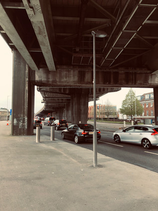
But for now, surviving the passage under the M4 became the priority. The locals appeared able to turn a blind eye to its omnipresence - amazingly a run of tumbling homes and a parade of semi-open stores still fronted the scene as they had long before the Motorway arrived. Carville Hall Park was divided by the road soon after its purchase as allotments and playing fields by Brentford Urban District Council after the First World War. The house in the southern part of the park, Clayponds, falling into gradual disrepair in public ownership. It was perhaps never a salubrious site, hemmed in by Kew Bridge Goods Yard and the tarmac strip of the improved Great West Road. Today it was busy with families and footballers, the humid grime on the air apparently no barrier to sports. The road bucked north to avoid the tip of a triangle of railway land undergoing dusty and rapid redevelopment, then turned south again fringing the extremities of Gunnersbury Park. As a public park, this space dates from 1925 when it was purchased by the Boroughs of Ealing and Acton, while lying wholly within Brentford. The purchase, from the Rothschild family, was driven by a desire to keep at bay the encroaching public housing which the perhaps more enlightened Borough was busily building. The corner of the huge park closest to the A4 was soon given over to Gunnersbury Cemetery, a formally laid-out memorial garden which controversially provided a home for a monument to the Katyn Massacre of 1940, where Soviet troops conducted the murder of 22,000 Polish citizens and military officials and buried their bodies in mass graves in Katyn Forest. The black obelisk was a controversial addition to the cemetery in 1976 following considerable pressure during the Cold War to prevent a commemorative site in Britain. From the footpath, fleeting glimpses of the white stone Commonwealth War Graves flitted between the trees as the traffic howled and hooted under the canopy created by the M4. This wasn't the most peaceful resting place perhaps, but it was a world away from the grim discoveries of 1942. The traffic snarled and shuddered to a halt, tail-lamps flicking on like a red wave rushing towards me in the shadow of the overhead carriageway. I had reached Chiswick Roundabout - the launch and ending point of my long tramp around the North and South Circular Roads which was, in a sense, the precursor to this series of foolhardy walks into London from all angles. The scenery was familiar, but distorted by approach from the west. I crossed the A406 at the point I'd set off, still a mess of roadworks and confusion, and made my way around three-quarters of the vast churning traffic island. I struck out along a footpath which I'd never noticed before beside the houses in Surrey Crescent, which climbed to meet the road which soared over the roundabout. Looking back I tried to picture the scene in 1959 when Jayne Mansfield opened the flyover. The view west was still futuristic - a shimmering field of metal and glass offices and car showrooms as far as I could see. But I imagined that they'd seen the future shaping up a little differently back then in the Atomic Age?
In the middle distance, a train crept slowly out of Gunnersbury Station as the sun began to seep from behind a thunderous-looking cloud overhead. The stretch of road ahead seemed impossibly long, and frankly a bit dull. I'd entered the kind of West London suburbs I used as a proxy for years when contemplating the outskirts of the City: tree-lined, red-roofed and repetitive. I glimpsed myself in the window of a Porsche dealership, and noticed what the apparently disapproving sales staff had spotted: this guy wasn't in the market for wheels of any kind. I was dusty, sun-pink and my fading cap was pushed back on my head to facilitate the long view ahead. Chiswick seemed endless, but drew to a nexus in the angle created by the Great Chertsey Road and the A4: here sat Chiswick House - once a Jacobean retreat from London for the Earls of Burlington, rebuilt in the Palladian fashion by the 3rd Earl in 1719 following his excursion to the continent. The house had finally passed into the ownership of Middlesex County Council in 1929, following a spell as Chiswick Asylum - notable for relatively enlightened treatment of those considered by the Courts as insane. The grounds remained open to the public, but the Great West Road was very much the back entrance to the grand gardens. A little further ahead on a triangular plot hemmed in beside a Premier Inn, was William Hogarth's house. Built around the same time as the Burlington's were reconstructing Chiswick House but on a much less grand scale, Hogarth moved here in 1749 and lived here until his death. He is much celebrated in the street names surround the area, and a map from the mid 20th century even records a surprising modern-style cash-in next door at the 'Hogarth Laundry'. The house has been variously threatened with undermining by sand excavation, damaged by wartime bombing and encroached upon greatly when the A4 was widened by demolishing a number of streets to the north of the site. But now repaired and spared further indignity the house remains as a museum and an ancient Mulberry tree still stands in the walled former orchard around the house, having been carefully nursed back to health by the staff of Kew Gardens following bomb damage.
Hogarth's 'moralizing' paintings of London life are particularly relevant to this location too: his Beer Street depicting a happier, healthier population than the degenerate denizens of Gin Lane. Brewing has taken place at the nearby Griffin Brewery since the late 1600s according to Fuller, Smith and Turner - though the current brewery site began to expand after Hogarth's death, covering the green fields which he'd moved away from London to enjoy. The brewery today was a tumbling agglomeration of buildings of various vintages, stacked almost haphazardly behind a wrought-iron entrance gate. I'd visited once before, on a beery, now rather hazily remembered trip organised by a Highbridge publican. He'd borrowed a van from the local Sea Cadets and managed to score them a parking fine in a Residents Only zone, which he gleefully tossed out of the window as we screeched away homeward, bags clinking with bottled ale some of which didn't make it back to Somerset. As i walked the length of the brewery, I noted the wind rising and a marine bite on the air - the river was near, perhaps the nearest it would get on this walk, and I could taste and feel its presence. I'd briefly found myself on this stretch of road a while ago while making the crossing from Furnival Gardens, where Stamford Brook once flowed out into the Thames - once a busy working creek, until it was backfilled in 1936 as industrial use receded. Today I stayed north of the road beside Ernest Berry Webber's Town Hall building. Work started here immediately after completion of Dagenham Civic Centre and followed a similar pattern: a Portland Stone dressed lower level with red brick above in a style dubbed 'Swedish Georgian'. The impressive southern face of the building contained offices and a suitably forbidding entrance to the Treasurer's hall, flanked by stone carvings of the face of Father Thames by George Alexander, and likely some of his final civic work. The Town Hall was extended somewhat unsympathetically in the 1970s, the three huge arched bays of its grand, northern entrance lost behind a vehicle access and a tangle of stairways linking the new building to the old, however it remained in public use having endured the passing of the old Borough to the newly extended Hammersmith and Fulham in 1965. The street which ran the length of the building was named Nigel Playfair Avenue, in honour of the actor-manager of the Lyric Theatre. Originally located on Bradmore Grove but now operating in a modern building a short distance away, the auditorium was dismantled and reinstalled when the original premises was threatened with demolition in 1966. Playfair's exploits had previously been celebrated by other streets around the Town Hall, including Nigel Playfair Road and Macbeth Road - both obliterated when the Great West Road was extended towards the West End via the Cromwell Road Extension, which brought my route to the very doorstep of the City.
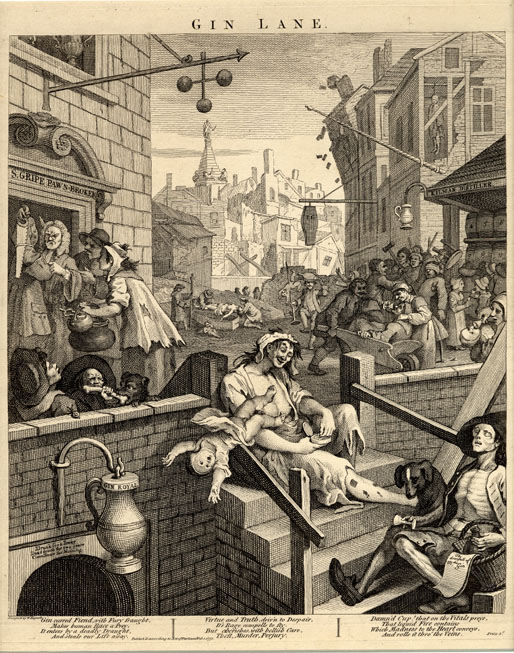
Plans to extend the Great West Road further into London had existed since the completion of the section to the Hogarth Roundabout in the 1930s. The planned route carved through Hammersmith, cutting into residential streets and gardens, and proved deeply unpopular. Instead the A4 decanted traffic unceremoniously onto the Broadway, clogging the busy junction between the two Hammersmith stations, before sluggishly stop-starting along Kensington High Street towards Hyde Park Corner. The Second World War throttled progress, but in the bold, post-war age of concrete and interventionism, a new plan was hatched for a slender flyover skirting the edge of Hammersmith on stilts to link the Great West Road with an upgraded continuation of Cromwell Road. The winning scheme was designed by Marples, Ridgeway and Partners - at the time still partly owned by then Transport Minister Ernest Marples who then scrambled to sell his shares via his partner. Soon after, the company secured the contract to build both the Chiswick Flyover and the Hendon Urban Motorway, despite reported lower bids being tabled by rivals. The dual carriageway would ascend on elegant reinforced concrete spans, carrying a system of heated cables which would reduce the need to salt or grit the road when ice formed. Opening in 1961, the road was already carrying more traffic than had been foreseen, but was certainly reducing delays. The heating system was also a success until the first cold snap delivered Hammersmith & Fulham a £4000 electricity bill. A tussle over payment saw the London County Council pick up the tab, but then swiftly stop using the cables in preference to regular gritting during cold weather. This almost spelled the end for the flyover, and in 2011 the whole structure closed due to serious safety concerns: the concrete cores of the pillars had corroded following fifty winters of salt and grit application. Transport for London raced to repair the strategic route in advance of the Olympic Games - money was no object when the IOC were coming to town it seems. Forced to turn aside by the flyover, I detoured briefly into Hammersmith to visit an old haunt for coffee. The knot of streets around The Broadway was pleasantly busy, the afternoon brightening as I headed east. It was soon time to return to the road for a last push into London. The flyover slowly touched-down on a windswept stretch of road between modern office blocks and hotels. I was the only pedestrian again, my progress along the semi-private stretch of pavement watched by almost pointless security cameras. Ahead, the bulky brick piles of Hammersmith and Fulham College filled what was once the playing field of St. Paul's School. In 1891, the view here had been so pleasantly rural that architect Frederick Wheeler selected Colet Gardens for St. Paul's Studios, a terrace of brick and terracotta dwellings for 'bachelor artists' which included lofty, arched double-height windows providing light and views across the fields. With Baron's Court station tucked neatly behind the studios, and a colony of artists already living nearby including Edward Burne-Jones, the well-connected location was swiftly popular with a series of young, up and coming painters. Now the studios looked over the relentless A4, a far cry from Wheeler's plan but still fetching prices which excluded even the most well-connected struggling artists.
The road was beginning to slow down, becoming a continuous line of city-bound traffic which nudged, nose-to-tail onwards. I passed over the complicated tangle of Underground and Overground lines which marked something of a boundary in the shadow of William Whiteley's Repository. Whiteley is widely regarded as the father of the modern British department store, having been inspired to become the 'universal provider' by a visit to the Great Exhibition in 1851 where he saw the wares of the British Empire laid out as if on sale. Learning the trade in the City while he forewent tobacco and alcohol to save the means to open a store, Whiteley opened his first premises in Westbourne Grove. He slowly purchased adjoining stores to assure him by 1875 of an unbroken run of shopfronts on the upmarket Queensway, from which developed a grand store in which he boasted he could sell everything from 'an elephant to a pin'. Here, beside the A4 his equally grand and capacious Furniture Depository still stood - a huge, ornate block which still dwarfed surrounding buildings boasting on its facade 'furniture and pianos displayed in mocked rooms' in a harbinger of the coming world of Ikea. Whiteley showed remarkable acumen, broadening his appeal by adding meat and poultry counters as the neighbourhood became less salubrious and more working class, but inciting the dismay of rival traders who protested his encroachment into their markets. His store was targeted by arson attacks on at least three occasions, reputedly from rivals who resented his all-encompassing business model. Whiteley's empire-building was unceremoniously curtailed by his murder on 24th January 1907, when he was shot dead at his store by Horace Rayner who claimed to be his illegitimate son. Found guilty and expected to hang despite a plea of temporary insanity, Rayner's sentence was commuted to life imprisonment when evidence indicated that the apparently generous and egalitarian Whiteley had not been quite the benefactor to his 6,000 staff which it appeared - in fact, he had been a bully and a serial philanderer. His family continued the business until 1912 when they sold to his arch-rival Gordon Selfridge, who had in recent times commenced trading on Oxford Street in his own great store. Whiteley's own palatial Queensway building remains, now an upmarket shopping mall bearing his name, while his Repository stared-down a gargantuan Tesco Extra across the railway tracks. It was hard to imagine William Whiteley not being impressed by quite how they'd packed a little of everything into the bright modern store.
A little further on, the A4 ceased any pretence at being an expressway, the dual carriageways merging into a single four-lane traffic jam between an avenue of mature trees and tall red-brick mansion blocks. This was the characteristic western suburb I'd grown to know in my earliest forays from Paddington. A little faded, but clearly still expensive and exclusive. I noted the crowds on the pavement thickening as I approached Gloucester Road station with its surrounding bloom of hotels formed from grand townhouses. The fine entrances from the street into opulent reception areas didn't convey how tiny the subdivided guest rooms were, or that there was likely no elevator available for the vast amounts of luggage just decanted from a Piccadilly Line train direct from Heathrow. It occurred to me that these arriving tourists had made the same journey as I - off the runway, over the Crane and under the suburbs to what they regarded as the 'real London'. I remained to be convinced, and while the grandeur of Albertopolis was almost enough to divert me into side-streets for better views of the sublime Natural History Museum or the Victoria & Albert, my bloody-minded refusal to get out of the way of the tourists hurrying and jostling towards me won out. I - quite literally - pushed on, into the crowd, accidentally cannoning into meanderers who stopped short to survey a telephone kiosk or some other on-brand bit of British street furniture. I realised that I'm at my worst in these areas, and that's largely why I avoid them. It wasn't outright snobbishness - more a mortal and an ever-present fear of becoming a snob. I've always been content to leave these zones to the tourists and the tour guides, let them mass on the pavement and impart stories which are far more compelling than those I rustle up from the docile suburbs. I passed into Kensington and things became even more congested and impassable. Harrods was a magnet, the looming, leering bulk of the gaudy frontage covered and under maintenance. People still snapped avidly at it, before sneaking inside for a carrier bag. The real customers cruised the A4 in high-end Mercedes and Bentleys, looking for on-street parking in the most conspicuous places possible. Beaten out by alert Uber drivers, they cursed and circled again, determined to be seen in the right car, in the right place. Here in the west, even the choice of illegal parking spot was a significant lifestyle matter. Head down, I pressed ahead to surface at Hyde Park Corner where there was at least some respite as the crowds peeled away towards Buckingham Palace. Piccadilly was a surprisingly pleasant walk, the quiet Portland Stone edifices of clubland giving away no secrets, and clearly expecting nothing of a perambulator from the suburbs. I felt at peace with my surroundings for the first time since crossing the railway back in Kensington. I was also acutely aware of the expectations on me to capture this part of the walk: people would call it 'the interesting bit' - far preferably to banging on about the marginalia. I was a poor witness though, content to let the city unravel around me as I walked back into the crowds at Piccadilly Circus briefly, before turning south onto Haymarket. Despite being the edge of Theatreland, all was quiet here: the matinees had begun, and the street would be quiet until early evening. The sun had made a break for it above me, and walking was now pleasant and warm. I looked forward to being able to get onto more familiar territory again, feeling a little lost out here in the West End. At the sight of George III on horseback, I turned east once again - the home straight was in sight.
Children slithered over the backs of the bronze lions of Trafalgar Square, barely able to stabilise themselves for the inevitable picture. Pigeons swarmed, more numerous almost than people. Buses jostled end-to-end. It duplicated the expectations, like every visit here - and like every filmed moment here - always did. Strangely though, I felt charitable towards the crowds who lolled outside the National Portrait Gallery or padded around taking selfies in telephone boxes. The city they came to see was the same one I travelled to for each of these walks - it was built on an international reputation which had allowed it to become the sprawling, confusing mess which I wanted to explore and understand. Without them, there would be no weird edgelands around Heathrow Airport, no endless suburbs stretching from the Crane to the Brent, and maybe no graceful concrete arc of M4 curving in from the suburbs. It could all be so different, but their celebration of a London I barely recognised outside a Richard Curtis movie or that one, clumsy two-part episode of Friends enabled the city I visited to exist, to work, to persist. As I passed the site of Temple Bar and entered the City of London I thought back to the huge 'Taking Back Control' billboards I'd seen in Cranford. The future was uncertain, our role as a financial power in the balance. Everything built here had sustained crashes and disasters before, but this time things felt self-imposed and stupid. It felt wilful and utterly British: a national cutting off of the nose, our face about to be mortally spited. I felt a mix of pride and vitriol: that I could walk these long routes safely and free from impediment was utterly British in character, but so was arrival in a place which might just be about to undergo self-immolation. The A4 proceeded along The Strand, into the City and down Ludgate Hill into the valley of the Fleet. I should have taken a final turn into Fetter Lane to conclude my route at a non-descript junction marked by a statue of Albert, Prince Consort who might just have been the patron deity of this last section of the route. Instead, I lifted my eyes to the dome of St. Pauls Cathedral and walked on, pausing to pay my respects to the Phoenix at the South Door. A little further on, once again revealed after a long disappearance from view, London Stone was visible behind clean glass and surrounded by fresh stonework. For years I'd grown used to peering down at the edge of the pavement, through a stained, yellowish window at the nondescript lump of rock. Now it could be seen properly - an irregular calcinate loaf of uncertain age, but certainly here for centuries. This felt like a fitting place to end the walk, at the very centre of London's onion-skin of layers. The clouds shifted overhead promising a fine evening after all the glowering storminess of the day. I almost regretted there wasn't further to go. But for now, this would do perfectly.
You can find more pictures from the walk here.
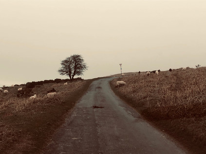
A Solid Mass of Heaven: A Weekend in The Borderlands
Posted in Travel on Sunday 31st March 2019 at 9:03pm
The drive into Wales was fractious and slow. The motorway was mired in congestion and overwhelmed with traffic, so we slalomed across the map heading steadily westwards on a successively narrower corridor of minor roads, a routing which made me - the navigator - distinctly unpopular for a while. Skirting major towns and curving along wooded channels, there wasn't much of a view beyond the monotony of a white line and the the threat of oncoming traffic. Finally, the valley opened before us: Hay Bluff glowered over the scene from the south, while our road briefly skirted the little town of Hay-on-Wye before heading into the countryside again. By a series of lucky turns and informed guesses we made our way to Glasbury-on-Wye and The Grange - the quiet bolthole we'd found for the weekend. It was good to get away - life had felt pressured and a little off-kilter these past few weeks. We were adjusting to new routines and new challenges, while integrating the same old pressures and stresses into a world where we both worked for the same employer. Escape felt well-earned and rare, and the fine old farm house with its casually friendly hostess and loping guardian hounds who were far too friendly to truly defend the place. We were instantly comfortable here, and celebrated by escaping to the local hostelry for too much food and wine. It was good to be in the Borderlands.
But this trip was also about exploring, and I was out early the next morning to make the walk beyond the pub and into the tiny hamlet of Glasbury. At the meeting of roads near the gateway to the common, I found a familiar sign: 'London Borough of Redbridge'. Oddly out of place here, the distinctive emblem and bold, plain design struck me first. I was transported to distant walks, connected strangely back to my wandering in the capital. Since 1963, the borough had sent groups of students - sometimes up to 1800 each year - to Glasbury to experience the outdoors and particularly the opportunity to canoe on the Wye. The future of the centre was first threatened in 2011 when subsidies fell, and it finally closed its doors in 2015 with the Borough seeking a £1 million receipt for the property against a challenging savings target. The building stands, decaying and apparently unsold while the signs still show the anomalous ownership. Instead of the fast-running Wye, the young people of Redbridge will be encouraged to enjoy the comparatively local Fairlop Waters instead. Having walked their edges recently, I can testify to the impressive sweep of the park and the windy lakes certainly looked well-used by boaters. But were they a substitute for the adventure of a journey out here? It was sad to think of this decades-old trip to the mysterious valleys no longer taking place.
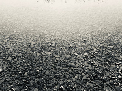
The Wye is broad and shallow at Glasbury, and I crossed the gravelled strand which led to its banks under the shadow of the road bridge. The river had scoured deep holes near the piers of the bridge which formed deep, dangerous pools requiring care in navigating a route under the carriageway. North of the bridge the river curved gently eastwards towards Hay, dividing into multiple streams and rejoining, and later we would set out in the same direction. My last visit to Hay was lost in a haze of confused sixth-form memories. We were brought here to experience the 'town of books' and to delight in the ramshackle cottage industry which presented its charming face in the old town. I didn't quite appreciate the rather ragged, hand-to-mouth existence of bookdealers then. Even these comparatively well-to-do country types existed in a world of unlikely fellowship and bitter competition. We'd get to see that a little on our excursion: enquiries after Beat Poetry in the wrong store incurred wrathful spitting of another bookseller's name. Try him. He likes that sort of stuff. We'd duly shuffle on, each with only a few pounds to spend on wretchedly ill-used paperbacks, hustled away from the glass-fronted cases containing the really good stuff. Don't even look. That's not for you. We scaled precarious spiral stairs to look an unsorted stacks of remaindered novels, and clattered into dank basements full of songbooks and sheet-music. It was both wonderfully educating and deeply depressing. I've struggled with second-hand shops ever since. Not until a visit to Powells in Portland years later would I even dare to seek out authors I cared to find works by, always feeling so utterly deflated by the sheer volume of pulped print around me. This trip was also one of the few times I got into any real trouble at school... On a brief stop in Cheltenham on route to Hay I'd strayed into Our Price records, and came away with a 12" single of 'Fishes Eyes' by New Fast Automatic Daffodils using virtually all of my spare cash. Later, we were ushered by our English teacher into a queue under a damp marquee, each of us duly bound to line up, purchase a book of poems and have it signed by D. J. Enright. Enright was virtually unknown to me then, aside from being the editorial credit on a number of anthologies. From what I'd seen of his work he didn't belong in my naïve, resolutely teenage canon. We shuffled forward, the better-prepared clutching their Collected Poems while the more thrifty held slimmer volumes. The author, heavy browed and bowed with age and likely boredom, smiled generously and signed almost unintelligibly. I assumed poets must all have terrible handwriting. I realised at some point in this slow procession towards Enright that I had neither book nor the funds to purchase one. I clutched the signature red 'Our Price' bag conspicuously, wondering how to play this? Despite my haughty assumptions, Enright was truly an impressive figure: I didn't know of his long sojourn overseas and the near international incident he'd caused in Singapore, I didn't know of his loose but important association with 'The Movement' and that last gasp of an older school of serious British writing. All I knew was that my literary pretensions lay elsewhere, and that my wallet was empty. I shuffled in front of the author in my turn. He smiled benignly as I offered him the New Fast Automatic Daffodils record. He examined it with a wry chuckle and said he'd not expected to see this. Eventually he took us his pen, scribbled something on the cover and handed it back with a gruff laugh before turning to the next in line. As I wandered away to inspect the record, I felt the eyes of my disgusted English teacher following me across the marquee. The inscription read:
I take no responsibility for the contentsD J Enright
I was suspended for three days as I recall.
Our day in Hay-on-Wye was very different: we found great coffee in the Old Electric Shop which combined café and retro furniture sales, strolled around the busy town and explored both a shop devoted to selling maps and the wool and food stalls in the restored Butter Market. The sun blazed over the town, and I decided that rather than return in the car I'd walk back to Glasbury along the river as far as I could. We parted at the top of town near the currently under re-construction flanks of Hay Castle, and I slipped into a store to buy a little vintage brooch which Natalie had admired earlier. before setting off for the river. Access to the river was down steep steps which turned back under the road bridge and onto the path of the former Hereford, Hay & Brecon Railway. The line had closed in 1962, leaving Hay at least twenty miles from a railway connection. Taken over by the Midland Railway, the route was joined a little to the north of the station by the Golden Valley Railway, heading east from Abergavenny and Pontrilas. The railway now was a broad, well-surfaced path running alongside a steep bank down to the River. It was quiet and cool here, just occasional walkers to distract me from my mission. The town was above me but could be miles away for all its intrusion into this calm, green cutting. In fact, I was passing out of town without realising - crossing the little Login Brook which trickled by the church of St. Mary the Virgin before reaching a tumbling confluence into the river below. Here I faced a choice: press on along the old trackbed, or head onto The Warren. I wanted to stick to the river, so I took the latter route, taking a broad sweep long the river bank where it curved around private meadows criss-crossed with unofficial paths. My presence, along with that of other groups of walkers and bathers was suffered if not sanctioned, and I followed the bank as far as I could, passing a busy weir where the already broad waters of the Wye scurried over stones. Eventually I was forced to head inland, and I soon realised there was little hope of getting back to river or railway. Instead I trudged alongside the busy road to Brecon, occasionally needing to edge along the dusty carriageway when the margins of the lane were impassible. It was challenging walking, and not what I'd hoped for, but the views were incredible - as was the chance to gaze down into the clear, angry waters of the Dulas Brook and Nant Ysgallen as I passed over bridges which I'd entirely missed when we travelled over them by car. As I neared Glasbury, I ascended a steep set of wooden steps onto the railway alignment, which cut into the lower foothills above me. The last mile or so of my walk should have been through a cool, wooded nature reserve - but a farmer, tired of walkers using it as a through route, had closed the end. I was forced to retrace my steps and to edge along the road yet again. I delivered the brooch proudly, a little dustier and more tired than I'd planned to be, but glad of the walk. We headed back into Hay later, to eat in a curious and rather secretive little restaurant and to drink a little more wine than I'd usually venture. I felt I'd earned the refreshment.
On our last morning, over an excellent breakfast, our host asked if we were going to travel home via the Gospel Pass. I knew we were close to Capel-y-Ffin and Llanthony, but hadn't hazarded a mention as I figured the drive would be very challenging on more, even narrower roads. These long-contested borderlands had featured in the confoundingly complex, dreamlike novel Landor's Tower by Iain Sinclair - and while I'd seen this as a minor distraction from his London writing at the time I first devoured it, I'd been haunted by the unseen landscapes and occult associations ever since. Surprisingly, the suggestion was eagerly accepted and after taking leave of the friendly dogs and the beautiful room we were soon heading off towards Llanigon, climbing slowly on a single track road. We saw very few other vehicles, a mist descending as we climbed towards the pass where England met Wales. The driving was exhilarating at times, the road hugging the edges of long drops into the valley below - and as we climbed we realised we we driving into a cross-country cycle race and needed to pause occasionally to let each cluster of cyclists pass unhindered. The road climbed towards the ridge and opened into a square of gravel which served as a carpark. We were surrounded by sheep, their eerie cries muffled in the foggy air. Lambs tottered along behind their mother, while groups clustered along troughs of feed. For a while it was just us and the sheep up here. The pass: Bwlch yr Efengyl, may derive its English name from one of two christian myths: that Caradog brought St. Paul through the mountains here to preach the faith to the heathen Celts, or that Crusaders passed by in the 12th Century preaching and raising funds for their expedition to the Holy Land. In either case, it has an ancient feel. The earth seemed to settle slowly when stepped on, the fog to part unwillingly to let us pass through. The sheep were unaffected, able to scamper and gambol along the mountainside at will. Humans though, were less welcome now. We pressed on, down the valley to pass the tiny church of Capel-y-Ffin - the Church of the Boundary - and to descend to the ruined priory at Llanthony. There had reputedly been a place of worship here since Dewi Sant established a cell in the 6th century. The first priory was established in 1108 via the finances of the de Lacy family and had become an important Augustinian house by the 12th century. However the priory faltered as attention turned to power struggles in the monarchy at the time of King Stephen, and the 4th Prior, William Wycombe took flight to Gloucester where he established Llanthony Secunda in the comparative safety of England. The de Lacy family once again took back the land and built the vast church which can be seen in part today, surviving despite the lawlessness and rebellion which stalked the borderlands and the rebellion of Owain Glyndŵr which threatened the Abbey's income and existence.
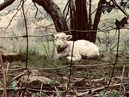
Llanthony continued to attract new groups of the idealistic and faithful, often with unlikely leaders. First came the troubled and hot-headed Bath born poet Walter Savage Landor, intent on improving the monastery but quickly falling into dispute with the locals who stole from him and failed to undertake the works he specified. His tendency to attack opponents in libellous verse saw him fall into further expensive and interminable conflict, and he finally left Llanthony for Jersey in 1814 at speed, reputedly having been flung from a first floor window by an unhappy local. Landor was followed by Joseph Leycester Lyne who arrived in 1869 making repeated attempts to buy the Abbey ruins from the Landors to prevent the operation of a public house in the grounds and to restore a religious order, based on his own strange take on Christianity. He finally admitted defeat and purchased 32 acres of land nearby to build a new monastery. Styling himself Father Ignatius, he established Llanthony Tertia where his eccentric collision of High Anglicanism and Celtic mysticism would ultimately fail to flourish. Diarist, clergyman and nudist Francis Kilvert observed that the guileless abbot was 'robbed blind' by tradesman he paid without a contract to finish the monastery, and Lyne fell foul of the Church authorities after publicising ghostly presences and visitations by the Virgin and reportedly being ordained as a Druid. It's perhaps easy to understand why Lyne would find this spot imbued with ancient power: the veil of modern life felt as transient as the mist here, and the idea that the old and new were entwined was strong. The Honddu valley slumbered unquiet under the dew and it was possible to imagine Lyne striding out, the hem of his robe damp, to meet figures which disappeared before he could speak with them. Nor was Lyne the last to attempt an understanding of this landscape, with sculptor and typographer Eric Gill setting up a somewhat notorious artistic community in Ignatius' unfinished monastery buildings. Gill's acolytes included the painter and modernist poet David Jones who drew on mythology and mysticism in his work, much to the cost of his reputation in the future when such things fell out of mode. Gill's reputation too has suffered from revelations about his personal life and proclivities - and there is a queasy realisation that his establishment of a commune at Capel-y-Ffin may have been as much about being away from the gaze of authority and polite society as any great artistic purpose. In both cases though, these men drew on the strange power of the little Honddu valley in their work. Gill left the valley in 1928, four years after arriving, reportedly troubled by its atmosphere, inaccessibility and great distance from London where many of his clients were located.
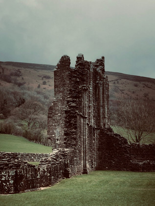
After exploring the ruins, we ventured into the tiny bar which still operates in the undercroft of the Prior's quarters. We were welcomed by a bluff and friendly man who spoke with the assuredness of a local, despite sporting a broad Mancunian accent. Delighting in the chance to tick Washington off the list of states he'd served visitors from, he talked a great deal about his association with the area and his return each spring to operate the pub over the busier summer months. He also talked about the range of celebrity visitors, including Jimmy Page who had called in while passing through the Ewyas Valley on route to recording commitments. The well-stocked little bar-room was accessed by precarious steps, and soon all attention focused on getting an elderly local safely to a seat nearby. We purchased a copy of the undated pamphlet by L D Fancourt which provided a brief history of Llanthony, skirting some of the more lascivious details of later occupants, and slipped away back to the car, to complete our journey. The road levelled, crossing and recrossing the busy Honddu as it rushed to join the River Monnow and eventually the Wye as it snaked towards the Severn. The arms of the valley slipped back, opening into a broad undulating plain surrounding The Skirrid or Ysgyryd Fawr, the shivering mountain which still experienced minor landslides but which was said to have partially collapsed in a lightning storm at the moment of Christ's crucifixion. Beneath it, the Skirrid Mountain Inn still did business - reputedly haunted by those hung at a local assizes which held session and dispensed justice here in an early sort of one-stop-shop arrangement, or by slain rebels from the time of Glyndŵr. Myth and mystery were never far from the surface here on the border, painted and written over and over: Jones, Gill, Eric Ravilious, John Piper and even Allen Ginsberg had passed through. With this surprising revelation my circle closed with an unexpected jolt, and I was the temperamental youth looking for Beat Poetry in the musty stacks of Hay bookshops once again.
As we climbed the silvery ramp of the Second Severn Crossing, I felt the unexpected weight of history slipping away from us. It had been wonderful to be back in Wales after a long absence thanks to its association with unwelcome appointments at the Home Office Immigration & Visa Centre. Now we could rewrite our own Welsh story, in a similar way to those who'd occupied the venerable and desolate valley through which we'd passed. It felt a little like our own pilgrim's road, and I was surprised how strongly I felt the curious pressure of time and place in the Borderlands. I scolded myself a little for letting my rationalism slip for a moment, but suspected that it was the natural rather than the supernatural which truly held sway in Ewyas. It had been a fine weekend and we'd found a special place to which we wanted to return. But the journey home had been surprising and enlightening. The valley still had more secrets to share.
You can find more pictures from the trip here. This post takes its title in part from Allen Ginsberg's poem 'Wales Visitation', you can watch him reading part of it to an unconvinced William F. Buckley Jr. below...
Lost::MikeGTN
I've had a home on the web for more years than I care to remember, and a few kind souls persuade me it's worth persisting with keeping it updated. This current incarnation of the site is centred around the blog posts which began back in 1999 as 'the daylog' and continued through my travels and tribulations during the following years.
I don't get out and about nearly as much these days, but I do try to record significant events and trips for posterity. You may also have arrived here by following the trail to my former music blog Songs Heard On Fast Trains. That content is preserved here too.
