Completing a project is something of an unfamiliar feeling here. It's rare I actually hold to a course for long enough to achieve any sort of goal, and even less common to feel that I've actually done justice to standards I've set myself. However, over the first five months of the year, as an act of either penance or thanksgiving depending on the overriding feeling at the time, I'd walked the five ordinal routes into London. So what to do now? I knew that my recording in writing of these routes was woefully behind - life without a perhaps somewhat extravagant laptop had curtailed my opportunities to bunker in the corner of a Costa Coffee and churn out words or retrospectively research places I'd found. But still, I needed to be out walking. June presented itself with a few options, but I had a hankering to get back out to the east of the city. I hadn't ventured east of the A1 since a fateful walk in December where I'd set out not really knowing where I'd head. So today, perhaps I'd try the same basic approach? I knew that I wanted to find evidence of a couple of streams in the east that hadn't figured in my treks before, and I had a rough idea of a way to combine them into a longer trip. I also had a hunch that I'd end up at the Museum of London Docklands at some point. I decided to throw all of this into an unplanned recipe for a day which should, after all, have been a celebration of freedom from rules or methods. This was probably not the soundest basis for planning a walk which needed to function as my treasured monthly excursion, but nonetheless, I set off into the suburbs.
I was one of very few passengers to alight at Gidea Park. The brand new train I stepped from was intended to have sped me under the city, from Paddington directly here - but its purpose was humbled by the continued delay to Crossrail. Instead, it droned away east, mission foreshortened, leaving me on a quiet platform under unexpectedly leaden skies. I set off out of the station, aiming for the southern exit onto Station Road. My route took me further east along the railway fringe, passing south of the fan of sidings which housed inactive commuter trains between the peaks. I crossed Upper Brentwood Road which led north towards Gallows Corner, passing through suburbs which now covered the grounds of Hare Hall, a Palladian mansion completed in 1770 for John A Wallinger. The building, now much encroached upon by housing, has served as the Royal Liberty School since 1921 and has the distinction of being the first British school to install a computer - an Elliott 903 operated by paper tape, purchased in 1965. Beyond the junction, I headed along Squirrels Heath Lane. This name appears almost lost from the map aside from this lane and the adjoining road which stretched east to the administrative limit of London. Locally, it appears that Ardleigh Green is the preferred nomenclature, with its connotations of sleepy Essex village rather than the dangers of a bleak, rodent-plagued wasteland. Ironically perhaps, the hamlet from which this new name has slowly crept west was once Hardley Green, which is perhaps more descriptive of the sunbaked concrete and brick vista I found today. Nevertheless, near the patriotically proud point blocks of Elvet Road (Victoria, Elizabeth, Edinburgh, Mountbatten) I finally found my first target: from the edge of the David Lloyd leisure complex, the tiny Ravensbourne trickled in its narrow culvert.
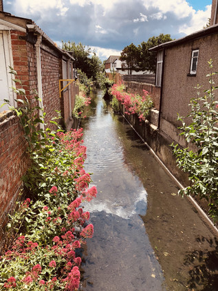
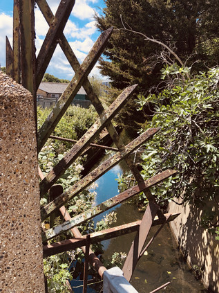
There are two Ravensbourne streams in London - and it is fair to say that this is the lesser in stature. Rising near Gallows Corner, and running between the backs of suburban streets, it makes a first accessible appearance here among the comfortably appointed homes of Havering. While its southern namesake strikes out across the wild spaces of Bromley Common, this little stalwart stream has done well to avoid enclosure during development - perhaps only saved by the need for surface drainage in order to build on the uncommonly flat floodplain here. My first sighting was inconclusive: a burst of greenery between two houses, and a tell-tale brick wall synchronising with a notable dip in the carriageway. It was going to be a day for this kind of evidence - stolen glimpses of sluggish water, traced by contour and instinct. I turned back and headed south along Northumberland Avenue, a long street of impressive detached properties which shadowed the river. Behind its back gardens was Haynes Park, for which the Ravensbourne formed the western perimeter - but there was no clear entrance from the north. Instead, I entered midway along the park's western side via a wide driveway surrounded by green municipal railings. The twin towers of Haynes Park Court overshadowed the park entrance, two of the smattering of tall blocks in an expanse of otherwise low-rise housing. Designed by Thompson and Whitehead who don't appear to have ventured into this type of work often, these blocks were erected for the rather prosaically named Multistorey Housing Association in 1966. They slumbered on, decaying into a rather grim state until recent refurbishment of the gloomy galleries and stairways. It's hard to say whether this was a result of their one grim moment of infamy when a young man plunged from the ninth floor of one of the blocks in 2012. I found few other references to the work of Thompson and Whitehead save for a tiny, modernist church in nearby Becontree dedicated to St. Cedd - bishop of the East Saxons and patron of Essex.
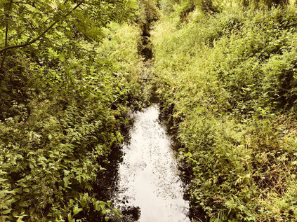
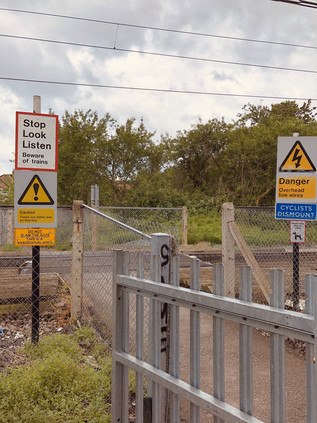
I let the river make the going, doglegging through the streets along its subtle contour line. After spying it passing under a fine little concrete balustraded bridge, I tracked the course via the appropriately named Brooklands Gardens, finding the Ravensbourne constrained in a deep culvert where Lewis Road inexplicable mutated into Warrington Gardens. Presumably, the river had at some point marked the boundary of developments here. I found it again in a marked depression on Hillview Avenue, behind a tidy brick wall with a well-secured metal access gate. I now had to pass a manmade barrier in the form of the Romford to Upminster railway line. This tiny link between the lines from Liverpool Street and Fenchurch Street survived against the odds, now part of the Overground network and served by a train shuttling back and forth via the single intermediate station at nearby Emerson Park. The line was unusual in being crossed by few bridges, and featuring instead a number of at-grade foot crossings. It was one of these I was aiming for now, via a surprisingly long diversion to the west and along a rutted back-lane behind homes and garages. During the cutting of the line in 1892 an unusual geology was uncovered, with sand and gravel overlying a thick bed of boulder clay. This signified the most southerly extent of the Anglian ice sheet during the longest and fiercest ice age of the Pleistocene era. The upper layers of sand had traveled from the Midlands, deposited here on the edge of the Ingrebourne valley some 450,000 years ago. The residents of South Hornchurch crossed the railway line with due care, seeming largely unawed by the great history of the clay dust their feet kicked up at the edge of the ballast. South of the railway I turned back east, finding the river again at its slewed crossing of Osborne Road before taking a turn into the long avenue of Lyndhurst Drive. The river was out-of-bounds again, ploughing between back gardens and then bordering allotments on the site of the former great house of Grey Towers. Built in 1876 for Lieutenant-Colonel Henry Holmes, the owner of the Hornchurch Brewery, the crenelated mansion passed into military ownership on the owner's death in 1914. Used initially as a depot and base for the 23rd Royal Fusiliers - the Sportsman's Regiment - from the summer of 1916 it became the New Zealand Convalescent Hospital with 1500 beds available for injured troops returning from the front line. Increasing casualties saw it expand by a further 1000 beds before it closed in 1919, with the last troops departing for New Zealand in February 1920. Pressure on land for suburban growth saw Grey Towers demolished in 1931. A nearby neighbour, the much older and somewhat grander Langtons - also built for a brewing family - was gifted to Hornchurch Urban District Council around the same time, but survived due to a covenant on the gift which required it to be used for municipal purposes. Langtons survives as the local Register Office and was briefly at the centre of a High Court case where its license lapsed and the legality of 193 marriages was placed in doubt. Meanwhile, no trace remains of Grey Towers, save for the name of a new development of houses near the allotments.
A crossing of the busy A124 caused me to re-orient myself: I'd passed this way before, and recalled the awkward bend at the bottom of a dip where I had to make a swift crossing of the busy east-west route at the venerable Ravens Bridge. Ahead of me, the broad green space of Harrow Lodge Park opened out, with the river and path sticking to the eastern edge and skirting the carefully prepared cricket pitch. The huge park was laid out on land donated by Richard Costain and Sons during their construction of Elm Park Garden City and occupies the site of the 16th-century manor house of Maylards. The park was pressed into use as a market garden during World War II, with the decommissioned fields redeveloped as leisure facilities after hostilities ceased. Around the same time, a comprehensive redesign of the park took place with the Ravensbourne dammed between 1954 and 1956 to form a large boating lake. I followed the river to its outfall on the lake, noting the sudden rise in the wind when I stepped away from the treeline. The lake surface was serrated with waves, the park largely quiet aside from the cluster of activity around the café. It made for pleasant walking, crossing the lake via a bridge at the centre and heading into the wilder part of the park to the north rather than following the path. In the event, all routes led to Upper Rainham Road and another familiar spot from my walk along the Beam River. I crossed carefully, heading along The Chase - a route I'd abandoned on my last walk as too treacherously busy with four-wheel drive vehicles conveying the local young women to an equestrian centre. This time I decided to persevere, swiftly finding the shameful spot where I'd crashed out of the woods beside the Beam and turned aside, cowed by the unexpectedly rural aspect of the zone I'd stumbled into. A little way to the south, the Ravensbourne trickled into the Beam, much reduced in feeding the great lake in Harrow Lodge Park. I followed the lane west, passing through the yard of the Eastminster School of Riding and into a narrow lane, overhung by trees. At some point, soon after passing the heavily fly-tipped opening of the path I felt like I'd passed out of suburban London entirely and into the lost farmland landscape of West Essex.
My route through Eastbrookend Country Park was perhaps the most pleasant part of the transition between the two rivers I planned to walk today. A relatively rural stretch between the park and neighbouring cemetery opened into an insalubrious lane frequented by cars with their engines running, edgy van drivers taking power naps and a cluster of Deliveroo staff holding some sort of clandestine workers' council. I soon met the curve of Dagenham Road which led into the edges of Becontree. The crossing of the great estate was hard going: the pavement tough on the feet and the strange monotony of the expansive sprawl of houses stretching seemingly forever. I found a shop to purchase lunch and ate on the hoof, not wanting to delay here. I struck a northwesterly path, aiming to cut across the central spine of Valence Avenue and to turn aside at Bennett's Castle Lane. My target was South Park on the edge of Ilford which felt impossibly distant as I slogged along the dry, windswept pavements walking into the gale. I felt stretched and tired, and the walk felt purposeless and vague. I briefly crossed my own path once again at the entrance to Goodmayes Park where the little Mayes Brook sputtered along unseen under the road. Compared to the rivulets I was tracking today, the brook felt like a more substantial target and I again began to doubt my purpose. Undeterred I stumbled on through the eerily homogenous bungalow-scape of the Mayfields Conservation Area, dumping my plastic bottle into one of the multitudes of recycling canisters on each identical driveway, surely a proliferation not expected when the area was designated in 1991 and the scourge of satellite 'dishes' was the borough's main concern? I finally emerged onto South Park Drive, realising that the entrances to the park were at the north and south extremities, and arriving squarely between the two I would need to walk the length of the park to enter. I cut my losses and headed south, tiny tantalising glimpses of the lake formed by Loxford Water inside the attractive green space.
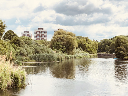
It's unclear where Loxford Water rises now, with the coming of the Great Eastern Railway and urbanisation of the area much altering the local geography. It flows into the ornamental lake in the park as the Seven Kings Water, a stream which was itself diverted to run along the northern side of Green Lane at some point prior to the late 19th century, rather than following the ancient line of Water Lane which was likely its original course. Above the confluence there appear to have been two streams, with the Loxford Water rising somewhere in the brickfields near Ilford Cemetary in a spot once known as Sam's Green. In any case, my first glimpse was of a narrow, buddleia lined channel between the homes on South Park Terrace. Unusually, as it cut across the pattern of streets - all aspirationally named for leafy Surrey suburbs - it appeared that the locals had embraced the stream. It was clean, free from dumped litter for the most part, and felt part of the urban geography of the suburb which bore its name. I tracked it south, dipping into the side-roads to steal glimpses as it converged on the main road, finally running in a deep, steep-sided concrete channel on the western flank of the street. I calculated that if the Seven Kings Water had in fact followed Water Lane it would have had joined the Loxford Water somewhere under the mini-roundabout on Dawlish Drive. I surveyed the scene - it all felt somewhat unlikely. The rivulet had gone native and now belonged to the suburbs, not the ancient countryside. I walked alongside it for as far as I could, pointing my camera through a fence at the point where it swung west behind Loxford Social Club, towards an impressive new school building. I continued south to the entrance to Barking Park where I could again walk alongside the Loxford Water as it edged around the long lake created from its flow. The park opened in 1898, the first such park to be operated by Barking Urban District Council, and it was widely regarded as the finest in East London at the time. The long lake was a major feature from the outset, once plied by a paddle steamer called Phoenix II which carried visitors almost the entire length of the park. The busy lido, closed since 1988 is now a 'splash park'. I tried to walk along the narrow sliver of land between the stream and the lake, but it soon proved impossible and I returned to the path around the southern shore of the lake. I found a bench somewhat sheltered from the wind and rested awhile. The park was busy with walkers, hunched against the unexpected windchill on an otherwise bright summer afternoon. I ruminated on my walk, figuring that perhaps it hadn't been entirely as dull as I worried it may be. I hoisted my bag for the last stretch of the walk, following the lake to the gate and taking a final look at Loxford Water under the bridge before it disappeared into a final culvert between industrial units which led to the banks of the River Roding. I noticed it was possible that I could see it one last time closer to the confluence, but I decided to turn aside and head for the station. There were other rivers that needed my attention now.
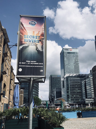
The train made the familiar, but always exhilarating journey across the rooftop-level viaducts of the East End, depositing me on the narrow platform at Limehouse. The station was laid out like an unearthed ancient arrowhead pointing at the city, formed by the convergence of DLR and railway. Feet tired, I took the lazy option, doubling back a few stops on the DLR to get to Canary Wharf. It seemed only fitting to approach the Museum of London Docklands via water, so I descended from the platforms to the dockside as soon as I could. The Canary Wharf estate had finally pulled off the ultimate regeneration trick: I remember weekend visits here years ago, being alone with the security guards in a deserted cityscape, but now the plazas and promenades were filled with people. This city outside the walls which had once been solely a workplace, abandoned outside office hours, now drew in an around-the-clock leisure-seeking crowd too. I navigated out of the busy, exclusive shopping centre and onto the waterside, crossing a bridge that afforded an excellent view of the inert Crossrail station currently functioning as an expensive roof-garden. The sun glinted from the surrounding towers, reflecting a cloud-flecked sky back at the dock surface. Across the bridge, in a Georgian sugar warehouse, the museum housed its latest exhibit: Secret Rivers. I'd vacillated about attending this event for some time, reasoning that I might be disappointed by something which skated too blithely over this topic which had occupied my thinking for so many years. Or perhaps it would take a prosaic tack, denying the rivers their ancient spiritual significance and talking up their industrial heritage over all else? I was relieved though to get over my vanity and visit because it turned out to be well-judged and balanced. The symbolic significance of London's lesser-known rivers was covered well, as was their gradual transition from rural streams to working rivers, and finally to shamefully culverted sewers. Some of the most interesting aspects of the exhibition centred on the rehabilitation of the rivers: by half-serious pressure groups, visual and audio artists, and of course in literature. A wall of books inspired by the rivers showed a long tradition of influence, and well described some parts of my own oft-repeated pathway to the banks of these streams. Not least, on one broad white wall, a quote from Aiden Andrew Dun describing the River Fleet:
The Fleet is a secret ditch, the kingdom of typhoid, a conduit of bad airVale Royal - Aiden Andrew Dun, 1995
The museum had done a fine job of pulling together the secular and sacred and had wrangled the attention of even the oddest cranks and freaks among us river-walkers away from our dubious texts and divining rods for now at least.
Perhaps the most arresting part of the display was a wall-sized map of the Thames estuary showing the tributaries of the river. I politely waited my turn for close inspection while a young family pored over South London. "You mean there's a river under our house!" a boy exclaimed to his amused mother, stabbing a pudgy finger at the convoluted line of the Effra. He was utterly captivated by the idea of a world under this one, entranced by something dark and presently formless, yet open to the imagination. I saw the spark of wonder which I'd found somewhat later than him - and I was thrilled to see it kindling the kind of excitement I still felt when I tramped about the suburbs on the trail of a rivulet or gully largely forgotten by most locals. I finally got my turn at the map and realised with a mixture of amusement and surprise that the rivers I'd walked today weren't there. Perhaps in my own childlike flight, I'd imagined them too? I set off west, towards the City, planning a call at the churchyard of St. Anne's in Limehouse where I knew a certain pyramid would be anchoring me to the earth, just like always. My history of London might be borrowed, butchered and misappropriated from all kinds of places, but that I could still lose myself here was very, very important.
A gallery of pictures from the walk and the exhibition are here.
Lost::MikeGTN
I've had a home on the web for more years than I care to remember, and a few kind souls persuade me it's worth persisting with keeping it updated. This current incarnation of the site is centred around the blog posts which began back in 1999 as 'the daylog' and continued through my travels and tribulations during the following years.
I don't get out and about nearly as much these days, but I do try to record significant events and trips for posterity. You may also have arrived here by following the trail to my former music blog Songs Heard On Fast Trains. That content is preserved here too.
