As my train lumbered across the junction and into the terminus platforms at Orpington station, I pondered the journey here. I should have been here a week ago, a long-planned and much anticipated weekend trip which combined a range of events and - for me at least - culminated in a long day of walking. Then it snowed - quite a bit in fact. Perhaps the most significant period of snow for eight years - and it was hard not to reflect back on that last period: a long, dark week of slithering to the station along ice-slick pavements and worrying about how I'd escape at the weekend. This time around, the weather reports and growing panic in the media had sparked my remembered anxieties again and I'd suffered through a week of doubt and concern - by turns feeling stupidly angry and utterly and childishly selfish. When the day came, we made a supreme effort to get to London - which it seems was by then recovering from its deluge - but the mixture of rather poorer local conditions and a train operator which is always keen to find an excuse to reduce or remove services left us stranded. We returned home for an extended weekend of staying indoors and watching the locals descend into feral, panic-buying lunacy. I filled my time with persistent bickering with customer service teams in a - mostly successful - attempt to gain refunds on our lost trip. We regrouped and replanned - there was no reason we couldn't try for next week... And so I found myself once again at the edge of London - this time in the far, largely uncharted south-eastern quadrant. The city felt distant and remote - this corner of London was almost squeezed out of the boundary, a hazy margin where bus routes terminate and Oyster zones evaporate.
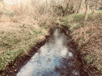
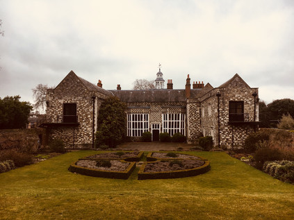
Outside the station, all was quiet. I had to remind myself that it was Sunday morning and also somewhat earlier than I'd normally be setting out. A cab driver quietly smoked beside his car, eyeing me expectantly as I left the station and turning away in disgust as I shouldered my bag and set off down the hill to the main road below. Despite the long genesis of this walk, my planning had been minimal - and had mostly focused on the later part of the route as the River Cray navigated broad open spaces on the edge of London. This, though, was just how I'd expected these commuter-fringes of the city to feel - sleepy, safe and strangely calming. As I turned north at a roundabout which encircled a war memorial obelisk, I began a long trudge up the broad and surprisingly substantial High Street. Most of the stores were still behind their protective shutters, but the tiny branch of Starbucks was preparing to open. I half contemplated lingering until I'd had more coffee - but I decided against it. It was a rare pleasure to have an entire day free for walking like this, and there would be time later for refreshments. So I passed by the inexplicably named 'Walnuts Shopping Centre' and progressed along the long, low stretch of mostly twentieth-century shops towards the northern edge of town. Orpington is easily imagined as a creation of the heady days of the last century - and indeed for a while in the 1960s 'Orpington Man' was the yardstick for the normal, suburban lower-middle classes who elected Liberal MP Eric Lubbock in a shock revival for the ailing party. However the town has a much longer and deeper history, first entering the record in 1038 when Eadsy, chaplain to King Cnut, gifted his estate here as a priory attached to Canterbury. Turning into a side-street which unexpectedly became a rural lane between weatherboarded cottages, I entered Priory Gardens via a side-gate. This unlikely mix of public park and formal gardens was added to the grounds of the largely still extant priory buildings by their last owners, Cecil and Lilian Hughes, before the site transferred to the ownership of Orpington Urban District Council in 1947. I took a slow circuit around the greenery, finally finding myself beside a broad and shallow pond with a stony bed visible beneath its clear waters. Here, where the clay of the Thames basin meets the wide swathe of chalk which stretches south-east to Dover, rainwater reaches the surface and the River Cray rises...
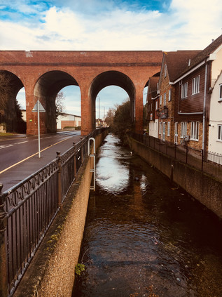
Once I'd located the source of the river I was keen to begin walking its route - however the London Borough of Bromley had other ideas. I'd noted a gang of workmen idly waiting for the clock to tick past 9am when presumably it becomes decent to raise a racket on the sabbath, but hadn't reckoned on their barriers blocking a small wooden bridge crossing the pond. I doubled back and circled the eastern bank while tame wildfowl clucked and fluttered around the edge, expecting food from any passing human. I finally regained my route at the end of the High Street where with traffic avoiding the notoriously sluggish section of the M25 scurried by on the A224. I crossed at the lights, cars screeching unwillingly to a halt at the signal, and headed north along the optimistically well-named Cray Avenue. I hadn't reckoned on much road walking today, and I wasn't sorry when at the end of a blue fence adorned with 'Jewson' signs, a gap in the hedge gave way onto a muddy path between three wooden stakes. I squelched between them, slithering along rather carefully, ready to retreat if needed until an emerging dog walker proved beyond doubt that there was a means of passing through. A muddy but reasonably firm path emerged and I plunged into the trees, emerging near a low brick wall around the head of a culvert. The Cray tumbled over a sluice and curved through the grassy strip beside the road. Faced with a choice between a more formal path and the continuation of the muddy riverside route, I took the later and splashed happily along beside the narrow but busy stream before emerging at a gate on Kent Road. Across the street the better surfaced path continued beside a low railing over the Cray, and I headed back under the trees towards the hard-to-pin-down village of St. Mary Cray. Until the coming of the railway, this village had been the heart a collection of small communities - The Crays - providing their market and mother church among other things. When it arrived, the railway crossed the valley via a nine-arched brick viaduct which swept it over the High Street of St. Mary Cray on its route out into Kent. This structure meant the station was constructed to the west of the village, to solid ground nearer to the curiously named environs of Poverest - a corrupted attempt to honour Margaret de Pouery, a landowner here in 14th century. Thus the modern village struggles to settle on a single centre. Near the viaduct a pleasant village green with a quaint wooden sign is surrounded by ancient shops largely now converted into dwellings, while the broad valley floor between the river and the A224 is filled with commercial and industrial premises including the carbon-copy units of the Nugent Retail Park. Even the vast Allied Bakeries site emitted no aromatic evidence of its craft this sleepy morning, while disgruntled punters struggled to leave the Mary Rose - a 16th century coaching inn turned motel which has frankly terrifying reviews online. The river emerged in a narrow channel beside the High Street as it passed under the high brick arches of the viaduct. A brace of guests wrestled their wheeled suitcases along the narrow walkway between the river and the rather gloomy looking extension of the hotel. Their faces betrayed a mixture of relief and disappointment. This is where London washes up against Kent - not far beyond the edge of St. Mary Cray there are open fields which stretch out to the nearby M25. Drained of life by the motorway, the commuter railway, the irresistible draw of Bluewater and the local retail sheds, this place feels dogged and depressing and quite different from the way I imagined it when scudding overhead on the rails. I decide to treat the viaduct as a point of transition and head north into what I hope will be less unnerving territory.
After passing the squat but solid church of St. Mary which was has been variously extended since the 13th century, I set off along Main Road - a long stretch of small millworkers' cottages mixed with more recent social housing, which led to a green space where the river broadened into a former millpond. The main course of the river and a sizeable part of the pond was tucked behind the back gardens of Main Road, but a bridge led over the river and ran alongside a busily burbling flood relief channel cut through the gardens on the course of a former millrace, to a tumbling sluice. The Cray disappeared under the road here, and into the former site of Nash's Paper Mill. Much of this site is now the rather anonymous Crayfields Business Park, but on a whitewashed wall a war memorial records those employees of the company who fought in the First World War, six of whom did not return. Poignantly enough, a much younger W.Nash is featured in the list. The mill survived to see a unique diary kept and published in a short history of the site, recording the efforts papermakers went to in order to ensure a supply during the bombardment of South East England in the Second World War. On the night of 2nd August 1944, the author casually records:
Papermaking under shell fire, but we kept going. Complaints about quality are receiving scant courtesy. People outside the south-east area have no conception of what we are undergoing.Extract from 'William Nash of St. Paul's Cray, Papermakers' - W.S Shears, 1950
The mill appears to have struggled on until around 1980, as Nash focused its operations on other equally venerable sites in Hertfordshire and Kent which subsequently closed too. Now the family business continues largely as a property company, the land around the river which drove the mills now their stock in trade. It was hard to conceive of vast quantities of fine paper, some destined for banknote manufacture leaving this quiet corner near the weatherboarded Bull Inn for well over two centuries.
At Pauls Cross, near The Bull I crossed Sandy Lane and began to head north and out into the countryside. The Cray ran below in inaccessible privately-owned meadows, the map showing tantalisingly broad lakes and grassy scrub which would have made for muddy but interesting walking. Instead I began a long, slow climb alongside a country lane which thundered with surprisingly fast traffic. Eventually, the narrow footpath rose away from the roadside and disappeared into a long, damp tunnel beneath the trees. The road could occasionally be glimpsed below, cars flashing by - slowing for the infrequent speed humps before accelerating crazily away again. The path was silent and empty, and I began to doubt this was a sensible way forward - a fear confirmed when I reached the Bannatyne Health Club driveway and the path disappeared entirely. Looking ahead, the road curved to pass under the A20 with little hint of a pathway reappearing. The traffic swished by my elbow, freed of speed controls and taking full advantage of this rural rat-run between the communities on the edge of London. A public footpath struck out towards Ruxley Wood, but that would take me much further east than I wanted to head. Reluctantly and rather dejectedly I retraced my steps to The Bull and crossed the river once again near the site of Nash Mill. I soon found myself back on the busy A224 at Sevenoaks Way - a broad arterial route built in the mid 1920s to bypass Orpington and the Crays. At Crittall's Corner it met the A20 at a bleak and busy roundabout. A damp underpass curled under the road, tiled with childlike images of the traffic above, emerging in the centre of the roundabout with the major road passing unnervingly close by overhead - apparently on a budget-saving flyover that wasn't built an inch higher than it needed to be. In the north-west nook of this junction, now occupied by a sizeable branch of B&Q, was the former Crittall Window factory. This southern outpost of a company more associated with Essex than Kent produced the simple but enduringly appreciated steel windows which graced many inter-war housing schemes and Art Deco masterpieces alike. The company enjoyed remarkable success in the USA too, and it felt cruelly ironic that this factory had disappeared as Coca Cola's European centre of operations arose across the street. It was here that the ill-fated Dasani mineral water was produced - essentially Sidcup tap-water treated with minerals to add 'healthy' properties. A little over a month after its February 2004 launch, the water was withdrawn when it was discovered that the mineralisation process produced harmful levels of Bromates in the otherwise completely safe-to-drink tap water.
The sprawling site which opened in 1961 was decked out in the company's distinctive red and white livery and stretched east to the Cray, preventing access to the riverbank. Instead I walked the road towards the crossroads at the heart of Foots Cray, now an outpost of Sidcup - effectively a suburb of a suburb. Named for the local Saxon landowner Godwin Fot rather than any bodily appendage, until the early years of the twentieth century roles here were reversed with Foots Cray the dominant settlement in the area and the seat of the Urban District Council. A mix of industrial decline and improved transport into London propelled the comparatively lowly Sidcup into the spotlight, taking the municipal honours formally from 1921. Despite this, Sidcup suffers a troubled time in the spotlight - the butt of jibes at suburbia and the inevitable origin of the mythical '08:40 train' which every hapless middle-class stereotype needs to catch. By 2015, the ever-dull James Corden was discussing this 'armpit of England' on his US chat show. In truth, the sliver of Sidcup through which I passed was surprising busy and interesting, and as I crossed into Rectory Lane and passed the tiny War Memorial, things became near-idyllic. The lane narrowed towards overhanging trees, only the imposing tower of a Victorian school building standing above them. Established originally by Benjamin Harenc Esq. in 1816, these remaining and much improved buildings date from 1883 with the pyramid-topped tower proclaiming in an inscription 'While ye have light believe in the light that ye may be the children of light'. Harenc was the son of a recently-arrived Huguenot who swiftly made good being appointed High Sheriff of Kent in 1777. Dwelling at nearby Foots Cray Place, a fine house built by Bouchier Cleve, the Harenc family appear to have remained connected to the area until the house was sold in 1822 by Benjamin who sought a permanent home near Sevenoaks. Sadly, he soon became unwell and died as a result of the great excitement and anxiety he experienced in personally overseeing a new endeavour linking Kent to Ireland and the USA via steamship according to his obituary in The Gentlemans' Magazine. Foots Cray Place burned down during restoration work in October 1949, but the vast grounds of the house now form part of Foots Cray Meadow, which I soon encountered via a gap in the low wooden fence and a damp, muddy path trodden into the grass which led around the back of the Church. I slithered and slipped along, wondering if this was a wise choice of route - but then, after a particular muddy trough in the path, a low bridge appeared crossing the River Cray. I was back on track at last.
It seems that on a dry, cold morning when people have been a little stir-crazy indoors because of a week of poor weather, Foots Cray Meadow is a popular excursion. Especially so it seems for dog walkers, who stalked the muddy paths in clumps with their excitable hounds capering around them. As I slithered around one group, blocking the entire serviceable width of the pathway, I noted their dogs tussling and fighting in the river as they looked on, mute and apparently disinterested. It was a bizarre scene - a total abdication of responsibility for their pets which almost felt like an organised dogfight. I trudged on beside the reedy banks of the river as it swelled into a sinuous pond dividing the huge expanse of green space, an area that was once a mix of open land and formal garden belonging to Foots Cray Place and the neighbouring estate at North Cray. At the midst of the lake, the almost too picture-perfect Five Arch Bridge arced gracefully across the water - the centrepiece of the work which Thomas Coventry commissioned from Capability Brown. The works, completed around 1780, included taming the Cray into the serpentine lake and weir seen today along with strategic planting to create attractive walks and carriage drives around the estate. While this reshaping of the meadows seems a fairly unimpressive task today, the effort and ingenuity required to undertake this in the late 18th century - and indeed purely for cosmetic rather than commercial purposes - remains somewhat remarkable. It is perhaps even more remarkable still that this spacious sweep of green space remains on the edge of Bexley within the desirable commuter nexus of the M25 and just a short walk from a railway station. The suburbs had gradually enclosed Foots Cray Meadow, but not yet encroached upon it. After passing the Five Arch Bridge with its cargo of dog-walkers and visitors the paths multiplied, and following a frustrating altercation with yet another dog and its owner, I elected to take the less-trodden and largely canine-free walk along the water's edge. The river was wider and faster here, still flowing clear over the chalk and stone bed which had first surfaced back in Orpington. Near Water Lane, my path edged along a fenced sports grounds behind the impressive Loring Hall. This fine house was originally known as Woollet Hall, and was built in 1760 to replace a Tudor house known as 'Wallets'. Woollet Hall was for over a decade home to Robert Stewart, Lord Castlereagh who as Foreign Secretary, masterminded the diplomatic and financial alliances which led to the defeat of Napoléon Bonaparte at Waterloo. In later years, as Leader of the House of Commons his frequent need to defend the actions of Lord Liverpool's unpopular cabinet weighed heavily on him - particularly after the Peterloo Massacre and the passing of the Six Acts designed to repress future disturbances and ultimately to prevent a British revolution of the type which had occurred in France and the USA. The mood of the public was echoed, perhaps cruelly, in poetry:
I met Murder on the way -
He had a mask like Castlereagh -
Very smooth he looked, yet grim;
Seven bloodhounds followed him
All were fat; and well they might
Be in admirable plight,
For one by one, and two by two,
He tossed them human hearts to chew
Which from his wide cloak he drew.The Masque of Anarchy - Percy Bysshe Shelley, 1819
Torn between the need to remain in the Cabinet to advance his diplomatic causes and his growing distaste for parliamentary business, Castlereagh confined himself to Loring House in a state of increasing paranoia and mental disturbance. By August 1822 when visiting King George IV he was clearly disturbed and in turmoil, utterly convinced he was to be blackmailed as a homosexual. Finally, on 12th August while left alone for just a few minutes, Castlereagh cut his throat with a small knife he had concealed from concerned servants. Even in death he proved a controversial figure - with speculation by William Cobbett's Radicals that the elitist government had arranged a cover-up to ensure a grand public funeral and burial at Westminster Abbey despite Castlereagh's ignominious end at his own hand. The Radical press too, whipped up sentiment against him in scenes which would not seem out of place today, advocating attendance at his funeral to cheer and exalt his passing. The final insult was committed again in poetry which rather eerily echoes the Twitter threads of our own time:
Posterity will ne'er survey
A nobler grave than this:
Here lie the bones of Castlereagh:
Stop, traveller, and piss.Epigram - Lord Byron, 1822
It was difficult not to think of the desperate and paranoid Castlereagh as I trudged across the windswept plain which separated North Cray from Old Bexley, his home now settled as a private school for children with a learning disability after several similar uses in recent years. The riverbank was again off-limits and I was diverted across a bridge and into a forlorn spot where the tidy inter-war housing estate ran aground in a scrappy concrete hardstanding used primarily for fly-tipping. An unlikely looking footpath was signposted along the edge of a tilled field which seemed to be growing only a crop of large, fizzing electricity pylons. I trudged on, figuring that as this still formed part of the 'London LOOP' it must, surely, go somewhere... At the end of the field, a brief scramble onto a wide, grassy plateau revealed a view west across to Bexley and east to the high ground of Joyden's Wood on the other side of the Cray Valley. The sun had struggled briefly above the clouds and it was surprisingly warm despite the strong winds. I stomped onward, through the swaying yellow grass and down a somewhat slippery approach to a private road serving Bexley cricket ground. The gateposts fulminated with prohibitions and cautions, clearly barely tolerating walkers descending from the muddy path. Suddenly, and with something of a shock, civilisation surrounded me again. The footpath ran alongside the railway embankment, turned to pass under the station platforms via a narrow brick arch and arrived suddenly in the midst of Old Bexley. Announcements of trains to London echoed overhead as I tried to adjust to entering this rather self-consciously gentrified village. This corner of Bexley gained the 'Old' part of its name in the 19th century as the new town of Bexleyheath was developed to eventually somewhat overshadow this little Kentish stronghold. The draw of the latter settlement's improved town centre also rendered much of Old Bexley's High Street rather cramped, old fashioned and unwanted, but it appears that a revitalisation has occurred with the street now lined with bars, cafes and boutiques which gave it the air of a theme park or shopping village. At the junction of the roads to London and Dartford, still a busy roundabout today, fingerpost signs high on a building pointed back up the valley to 'The Crays'. I followed the road to Dartford instead, passing an impressive run of former almshouses and the old National School on route to the intriguingly named 'Black Prince' junction where the six wide lanes of the formidably improved A2 crossed my path. Named for a local legend that Edward, The Black Prince haunted the area, the name developed from the presence of a nearby hotel and inn on the route to London. This mock Tudor building, a famous music venue in the 1960s, was now a rather tired looking Holiday Inn occupying a wing of the swirling road junction which now shared its name.
The Cray passed to the east here, running through the grounds of the improbably located Hall Place, a Tudor house nestled into a nook of the poorly designed road junction which send a bridge curving over the road between two tight, complicated roundabouts. Built in 1972 when the A2 was widened, this scheme dated from a time when concerns about the surrounding of a treasured historical site would have been less than paramount. Still less important was the tiny River Shuttle, a tributary of the Cray which had tumbled merrily from the higher ground of Bexleyheath before being unceremoniously dumped into a concrete channel under the road to finally reach its confluence with the Cray nearby. A junior football tournament was just finishing and I trailed over the bridge in the company of fathers counselling their young protégés on their performance while the mud was still wet on their boots. The striking contrast of Hall Place when it came into view was spellbinding - this house, built in 1537 by Sir John Champneys, Lord Mayor of the City of London seems an almost impossible survival. Much extended in the 16th and 19th centuries, the great hall looks west across the road while the later additions stand guard over impeccable formal gardens and celebrated topiary first planted in 1953 to celebrate the Coronation. Champneys was a son of Chew Magna in Somerset who lost his sight in later life, an event reported by London's chronicler John Stow as divine retribution for building a high brick tower onto his city home in Mincing Lane - as Stow's immortal quill put it "the first that I ever heard of in any private man's house, to overlook his neighbours in this city." During the Second World War, Hall Place became 'Santa Fe', a US Signal Corps station which intercepted coded Luftwaffe morse messages for decoding by the Enigma project. Following a spell as the headquarters of Bexley's library and museums service, Hall Place is now a thriving visitor attraction complete with shop and riverside café. The gardens certainly appeared busy, but it was hard to tell if the traffic into the site was heading here or for the carvery on offer at the Miller & Carter pub next door. I snapped a photograph of the front of the Great Hall, looking out onto what must once have been a far less urban aspect, noting the place for a possible future visit. For now though, I left the Sunday crowds to their roast lunches and football tournaments and struck out along the road to Crayford. The road followed the course of the river, which ran just out of sight beyond the carparks and sports fields - but I knew I'd soon be back alongside it.
Like many suburban satellites of London, Crayford was announced by the shining roofline of a retail park. A vast Sainsbury's store - once the largest in the UK - was the anchor for a sprawling development which dwarfed the Greyhound Stadium nearby. Once the dogs would have been the biggest draw in town, but now the supermarket pulled in the punters. Similar locations remain scattered across London - the sites of former stadia now given over to retail or housing developments. At Harringay, at Brent Cross and Clapton little remains except token nods to the long history of working class entertainment: speedway and greyhounds. Hives of night-time activity now reserved for late-night shopping or quiet suburban dwelling behind drawn curtains. Crayford's story at least, has a different outcome: when the site was redeveloped in the 1980s, the track remained central to Ladbroke's plans. Now hidden behind the fading red and grey facade it shares with the neighbouring Leisure Centre and which keeps it clearly anchored in its period, it still features regular races with restaurants and hospitality suites for the spectators. Crossing the reedy course of the river in a deep culvert, I entered the supermarket café in the hope that I'd find somewhere to recharge my 'phone and to get refreshments - I realised that I'd been steadily walking for hours now with no real break, and it was time to rest. I drew a blank in the massive store and headed instead for a coffee concession inside a branch of Next on the nearby Tower Retail Park. It's clear that Crayford has lost much of its centre to these vast ranks of stores and their associated car parks. As I sipped a cup in an ear-splittingly noisy branch of Costa Coffee tucked into the corner of the store I tried to imagine this as an industrial zone - the home of Hiram Maxim's factory which produced self-loading machine guns, supported by capital from Edward Vickers. Later, a complex merger which still sets legal precedent saw Maxim's operation take ownership of Nordenfeldt at nearby Erith, before itself being bought out wholly by Vickers, creating an enterprise which thrived during the Boer War supplying armaments to the British forces. The company endured lean times during peace, but a surge of War Ministry orders in 1914 ensured the factory's survival and the building of the nearby housing estate of Barnes Cray to cater for an expanding workforce. While the factory found many peacetime uses including manufacturing bottle-making plant, accounting machines and cars, its fortunes boomed during wartime, seeing considerable expansion in both 1939 and 1950 during the Korean War. By the early 1970s, with Ministry of Defence contracts largely drying up in the squeeze on public spending, the factory entered a terminal decline. By 1985, the small remaining plant was closed though some buildings lingered until 1998 when the site was cleared to become Next, KFC and Hobbycraft in due course. Crayford struggles on without this major employer, a town without a centre.
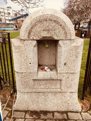
Leaving the coffee shop I realised that London Road was the route of Watling Street , the long straight road from Dover to London, and thence to Wales. The venerable route crossed the Cray near a little green between rows of local shops, empty benches lining its winding route. At the edge of the green a drinking fountain was inscribed 'Whosoever will let him take the water of life freely' and rather poignantly its now defunct-basin had been filled with empty Coca Cola and Stella Artois cans. I set off alongside the river, glad to be close by its banks again. The footpath here was better marked, and as I ventured onto a tree-lined pathway which left the road a large iron obelisk announced the Cray Riverway which shared the route of the London LOOP once again. Under the trees I was sheltered from the surprisingly strong wind which scoured the flat marshlands stretching toward the Thames, and I had a peaceful and pleasant walk between the backs of suburban homes and the water which still ran clear despite being heavily fly-tipped. I was briefly forced to detour into the streets of Barnes Cray, filled with sleepy Sunday afternoon dinner smells, before returning to the river as it ran through the scrubby marshlands hemmed in by the nearby Stanham River which formed the border of Kent. The river was suddenly a brackish, tidal brown - flowing sluggishly in a wider channel through the flat, empty landscape. A tell-tale waft of decay indicated the presence of the West Kent Main Sewer, taking a direct route towards Longreach Sewage Works on the Thames. The air was tainted with industry, a tang of metal and saltwater on the tongue as I navigated my way across the A206 where the Cray flowed beneath a low modern bridge. The brown water almost touched the parapet as it churned under the road, and I made a slight detour north to reach the west bank of the river's estuary. I soon found myself on a narrow, dusty and litter strewn lane which ran between a desolate, recently cleared site and a huge transport yard. The lane was quiet today, but I could imagine just how tight clearances would be on weekdays when the trucks thundered towards the waste disposal site up ahead. The railway from Dartford passed over a low brick bridge where a narrow carriageway had been lowered to allow taller vehicles to pass. In the recent rain and snow this had become a dirty sump of water which an unexpected passing car splashed into, almost grounding the low underside of the vehicle as it accelerated out of the filthy soup and sped back towards Crayford. I edged under the bridge on the elevated pavements, thankful that I didn't need to wade through the muck below. On the other side of the bridge, seagulls wheeled and cried as they flocked to the rich pickings of the waste disposal site. The sweet and cloying smell of rotting waste mixed with a strange reek of burning, and I noticed a somewhat professional looking camera operator framing the clouds of birds as they dispersed and reformed on the buildings and fences of the site. He politely let me pass, perhaps used to walkers interrupting his vigil - this was after all, somewhat surprisingly, still part of the sanctioned footpath circling London. The path turned a sudden corner between high concrete fences, twisting north again and climbing. The wind hit me at the top of the rise. Unexpectedly I found the view opened before me - smudges of clouds in a grey-brown sky echoing the wind-blasted grass and mud of Crayford Creek. The river was a sickly trickle at the foot of a deep, scoured channel. In the middle-distance, the Dartford Crossing arced over the Thames, beside it the towers of Littlebrook Power Station. On the opposite bank, a teenager throttled the engine of a scrambling bike to impress his bored girlfriend who stood by, idling flicking at a 'phone screen. The noise of the engine carried across the marshes, flat and empty - and seemingly endless. I drew the zip of my coat up to my chin to beat the cold wind, and set off along the final stretches of the River Cray. A little way ahead it flowed into the Darent at Dartford Creek, the two muddy channels combining in the midst of the marshes. The path was narrow but well-walked and had been scoured dry by the salt-laden winds. I fixed my eyes on the Dartford Creek Flood Barrier, and started walking.
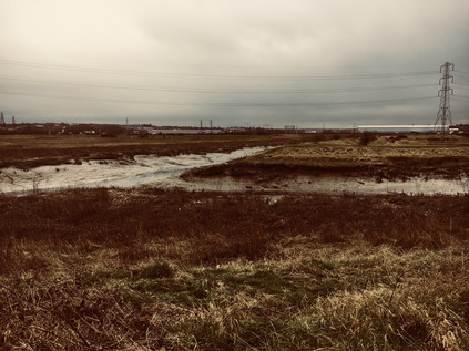
This lonely, windswept stretch of the Thames foreshore appeared entirely deserted now, but it had a long history of human use. The crack of gunshots marked the Dartford Clay Shooting club on the Kent bank of the creek, mocking the absence of the former Wells Fireworks factory which inhabited this spot from 1837 until driven out by cheap imported fireworks in the 1970s. The site had returned to nature, a scattering of decaying huts barely visible now indicating a works which had once created displays for Coronations, Jubilees and the Olympic Games. Beyond the factory was another absence - the site of a sprawling complex of hospitals which had been built out here, away from civilisation - and away from the opposition of local people who feared smallpox patients being treated near their homes. Land at Gore Farm in Dartford had been used for a camp for infectious patients since the 1890s, but the association with this site beside the Thames began with The Long Reach Hospital in 1901, hastily erected in temporary buildings by the Metropolitan Board of Asylums to deal with an especially virulent smallpox epidemic which was overwhelming the three hospital ships moored alongside the site, Atlas, Castalia and Endymion. A tramway was built out to the river, with patients arriving by river ambulance and being conveyed to the hospital by second-hand tramcars. Nearby, the much larger permanent Joyce Green Isolation Hospital was under construction in an effort to replace the ageing ships, but was not yet ready for use by patients. The Long Reach was soon struggling for space, and a further temporary site, The Orchard, opened in 1902. Finally in 1903, Joyce Green opened just as the epidemic of smallpox declined. The Orchard saw further use as a military hospital and convalescent home for Australian troops between 1914 and 1919 before being destroyed by incendiary bombs during the Second World War. The Long Reach meanwhile was rebuilt with more permanent facilities and maintained ready for future epidemics of smallpox, seeing a flurry of activity in the early 1930s and treating its final patients as late as 1973. Joyce Green Hospital survived much longer, admitting patients with a range of infectious diseases requiring isolation and housing over a thousand Russian refugees who arrived in 1918 having been exposed to smallpox on their journey. The hospital transferred to the London County Council before joining the newly-formed NHS as a general hospital in 1948 and remarkably remaining in use until 2000 when the newly built Darent Valley Hospital took over from a piecemeal range of facilities scattered around Dartford. Looking across the marshes towards the green smudge of Essex on the horizon it was easy to see the attraction of this wide, empty expanse of land to provide effective isolation. I thought about the staff, stationed here and subjected to daily rituals to remove and prevent infection - I tried to imagine the smell of carbolic scrubbed skin and burned uniforms. Even now as I trudged along the bank of the creek, the landscape challenged me to face its emptiness. Humanity seemed uncomfortably far away here, even to someone comfortable with solitude. The wind was loud in my ears, just the crack of gunfire and the buzz of the distant motorcycle engine joining the roar. Looking towards Kent, the reedy green land was empty now - but it had known suffering. Even the scars that the hospital wards had made on the land now fading under the reeds and scrub.
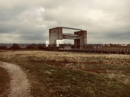
The creek curved and bucked, seeming to resist its final journey to the Thames, while the path struck directly for the tall concrete towers of the flood barrier. A warning light, erected on a spidery metal gantry explained that when it was lit the barrier was closed and there was no escape from the creek. It was hard to imagine boats navigating the deep muddy crevasse below, but Dartford Creek had once been used by Thames Lighters to access wharves in Crayford and Dartford, and there appears to be some effort afoot to restore the river to use by pleasure boats. As I headed for the barrier, the sun broke through the low clouds that had dogged my walk, and the marshes were suddenly illuminated. The distant bridge at Dartford shimmered in the spring sunlight, while the river rippled with bronze below, reflecting the yellow marsh grass. I was entirely alone now, the last dog walker miles away and the waste disposal plants which sheltered in the lee of the high bank deserted for the weekend. At the foot of the gigantic flood barrier I paused and looked back west: the broad thames turned south, Erith Reach twisting back towards Greenwich and the City. On the western bank of the Darent on the spit of land which protruded into the river the Thames Ammunition Works opened in 1879 in a seemingly ideal spot away from any great mass of population and with easy river access from the Royal Arsenal at Woolwich. During the Great War the site was taken into government control and briefly connected to the railway network, but by the early 1920s it was under the ownership of Messrs W.B Gilbert Ltd. On February 19th 1924, while the predominantly female workforce were disassembling shells to recover powder, a fire broke out on the site causing a number of large explosions. The remote and inaccessible site meant that help was slow to arrive, and eventually eleven women and a foreman lost their lives. The site is buried by new industry, its sad history largely unremarked now. Across the water, the mounds of detritus which had accumulated over a century at Rainham loomed large, the sun winking off passing trains speeding out to Europe as they emerged from behind the rubbish heaps. To the east, the little town of Purfleet was reassuringly familiar - the riverfront flats and hotel dwarfed by the arched hanger of the Royal Opera House Production Centre, while the low viaduct carrying the A13 strode across Wennington Marsh. I spent a while watching the scenery shift, the river changing from a deep olive to a surprising blue as the sky cleared. It was hard to imagine The Long Reach Tavern surviving near this spot - until damaged so severely in the infamous tidal surge of 1953 that it had to be demolished. In the 19th century the tavern had been infamous for cock-fighting and bare-knuckle boxing contests, and it had thrived on the presence of both the nearby hospitals and the aerodrome used by Vickers and Maxim for testing early aircraft prototypes, and later by Britain's nascent Air Force as RFC Joyce Green. There was no clear trace of the inn now, the flood defences built in response to the disaster which spelled its end having obliterated the ground on which it stood.
The temperature fell as the sun began to slide towards the western horizon, and it was time to head for civilisation again. As I turned to face west and begin my journey back to London, the sky was beginning to turn an ominous purple-grey. I joined the Thames Path and began walking towards Erith along a raised bank between the water and the ancient salt marshes. Decaying wooden structures strode out into the water - long forgotten piers and jetties which had been replaced by the modern yacht club I could see up ahead, a forest of masts clustering around the building. The path descended from the bank to skirt the yacht club, turning inland and onto the industrial roads leading towards Erith. I was tiring now, and the slog up a dusty hill while dodging puddles of suspiciously rainbow-tinted water outside waste management facilities felt like hard going. Erith was a genuinely strange place - once a resort described as a 'pretty little place' by Walter Bell in 1907, it had been relentlessly colonised by industry. The proximity to a calm stretch of river drew factories and railways towards the shore here, but they abandoned the town just as quickly as they'd arrived as industry on the river declined. At the end of Manor Road I spotted the disused parapet of a bridge which had once carried a branch of the railway to a riverside pier, now filled in and occupied by a flank of the huge Morrisons store which had, in turn, changed the face of the town's commercial zone. The centre of Erith was a down-at-heel shopping centre which used its ancient High Street as a service road. It was hard to know if the shuttered stores were closed because it was Sunday or if the centre was in more permanent decline. A few groups of young people hung around, and the last straggling shoppers shuffled home from the early Sunday closure of the supermarket. In some ways Erith's town centre felt less human and more helpless than the abandoned marshland of Crayford Ness. I pressed onward, under a slippery subway and towards the railway station. I wasn't sorry to be leaving Erith behind, though I had a nagging sense that this part of the world wouldn't let my imagination go now I'd walked the river. I'd expected little more than a decent, long walk today, but had found a surprisingly contested territory, continuously walking a knife-edge between being suburban London and semi-rural Kent. The Cray was a physical and emotional boundary, even if it didn't quite match the ceremonial boundaries, redrawn to enclose many of its once remote settlements within the growing sprawl of modern London. From the mannered and carefully primped park where it surfaced to the wild, sprawling, wind-blasted marsh where it gave up its waters to wider river, the River Cray inhabited a zone which was neither city nor country, neither town nor village. Watermills may have been replaced by retail parks and waste plants, but the river still seemed to drive a quiet and relentless industry. As I boarded a train back to the Sunday silence of a near-abandoned Cannon Street, I surprised myself by looking forward to being out here on the edge of Kent again.
You can find a gallery of pictures from the walk here.
John Cale (2018-1964): A Futurespective, The Barbican
Posted in SHOFT on Saturday 10th March 2018 at 11:03pm
It was good to be back at The Barbican. A complicated attempt to order at the cramped, circular cocktail bar aside, I was amazed at the functional brilliance of the building. As people zig-zagged around its corridors and levels to seek the correct entrance to the auditorium for tonight's performance, I decided it was a metaphor for the career we were here to appraise. For over half a century John Cale has taken sudden turns and switchbacks, has created musical landscapes which compare to the minimal concrete of the building, and has drifted in and out of mode just like béton brut. But like the solid towers of the Barbican, he has persisted in walking a difficult line between art and pop, form and function. It hasn't always appeared comfortable being John Cale over the course of the years in review in this Futurespective - but it has always sounded interesting to the listener out here.
Cale ambles onto the stage in a floating black gown, his indecently handsome features for a man of 76 years carved against the backdrop of the Barbican like a portrait of a proud Native American. Recent surgery and a leg-splint impede his progress to the keyboard, but he is all business. A drone sets up, shifting and churning as the band of people a fraction of his age and the London Contemporary Orchestra add colour. The backdrop shifts and stutters with odd projections and disquieting images. We could be anywhere between his earliest experimental compositions with La Monte Young or Terry Riley and the present day. Then the sound morphs into the familiar spoken-word strangeness of The Jeweller... The orchestra swirls, a choir joins the stage, the projections home in on a close up shot of a desperate, searching eyeball. We've set off on a tumble back and forward through time, while serene and serious, Cale pilots us from his piano stool.
What follows is a circuitous spin through a career as varied and strange as any of the curious bunch of oddballs and virtuosos who assembled themselves into The Velvet Underground all those years ago. From the formality and structure of Hedder Gabler from the mostly forgotten 'Animal Justice' EP to a surreal take on Lady Godiva's Operation adorned with shimmering electronics and shrieks of pain from sound architect Actress, the set borders on wilfully strange: Cale plays with us - taking us into uncharted waters with new arrangements of improbable songs before delivering solid, punchy versions of career stalwarts. A sharpened and honed take on Fear is a Man's Best Friend ends in howls and discordant piano hammering which seem impossibly passionate and desperate from the older, wiser Cale who is performing them. He draws surprisingly heavily on the 'Fear' album from 1974, sandwiching the critically less well-regarded but sublime pop of Caribbean Sunset between the edgy, glances-over-the-shoulder of paranoia from his earlier record. There are unlikely surges forward in time too - not least to the shuddering soundscapes of Wasteland from 'Black Acetate' where Actress against steps forward to augment Cale's composition with deep electronic growls and shudders.
Twice during the show Cale steps unsteadily but defiantly out from behind his piano and straps on a guitar - once for a searing Heartbreak Hotel and then for a closing encore of the familiar show-ending ensemble of Gun, Pablo Picasso and Mary Lou. All of this could have seemed like another turn around the same old songs, another self-congratulatory retrospective - but it didn't. Perhaps it was the orchestra providing spare, delicate accompaniment, perhaps it was the energetic band which showed respect for the material but never so much that it sidelined them into parody? The reason why this didn't feel like another ancient rock turn doing his bit became perhaps most apparent in an unexpected moment ... The presence of the choir of almost irrepressibly joyous voices came to the fore most prominently in the yet-to-be-recorded gospel of Pretty People, a thundering, enervating call to 'Rise up!' which Cale was trying out and feeling his way around just like a band of youngster's might do with new material just up the road in a grimy Hoxton back-room.
John Cale left the stage with a wave and a nod, feedback howling while the assembled cast of musicians waited, apparently stunned by what had just occurred. I got the sense that this wasn't any sort of ending - and was certainly nothing like the kind of through-the-motions plod which other acts of Cale's vintage indulged in with depressing regularity. It wasn't easy, simple or predictable - and in fact it probably probably represented yet another beginning in a career of improbable twists and remarkable musicianship. It had been a privilege to be present for this.
Lost::MikeGTN
I've had a home on the web for more years than I care to remember, and a few kind souls persuade me it's worth persisting with keeping it updated. This current incarnation of the site is centred around the blog posts which began back in 1999 as 'the daylog' and continued through my travels and tribulations during the following years.
I don't get out and about nearly as much these days, but I do try to record significant events and trips for posterity. You may also have arrived here by following the trail to my former music blog Songs Heard On Fast Trains. That content is preserved here too.
