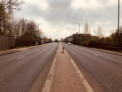
The bus deposited me on the southern side of a broad dual-carriageway with a generous but unbarriered concrete median. The road was eerily silent. I paused, wondering quite where I was and feeling the familiar tingle of anxiety at not quite knowing what I'd let myself in for. Suddenly the sky tore open above me with the blistering sound of jet engines bringing a Boeing 747 to a shuddering, gravity-defying safe landing after a transatlantic crossing. I'd walked in the flight path before, but this was unlike anything I'd experienced. Silent again, I turned east, against my better judgement, in search of a place to start walking. As is so often the case, a river provided the boundary: The Duke of Northumberland's River - formerly the Isleworth Mill Stream - ploughed a straight furrow under the road, separating the village of Longford from the ancient parish of Harmondsworth. A single car passed by. I wondered if there was some sort of incident or road closure, but it seemed that beyond Heathrow the road dwindled in importance. I was able to cross unassailed, pausing to take a picture back west. Looking along the asphalt, the long walk ahead of me seemed almost impossible from here at the edge of London. Strictly speaking, the boundary lay a few yards further to the west where the River Colne passed beneath the A4, but this spot somehow felt right. Records indicate that this watercourse was being worked on in 1530, bringing the waters of the Colne to drive mills and irrigate the fast-draining farmland on the Duke's estate. It is also likely that the labourers were not digging a new ditch, but refettling an already extant channel. For centuries humanity had tinkered with this landscape, reshaping and redefining it. Here on the edge of one of the zones of London most overwritten by human activity but in many ways least human in scale, I'd start walking west along the ancient road from my homeland to London. Another aircraft shredded the cloud-cover, overwhelming my already music-battered hearing. I started walking...
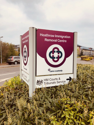
The road was still uncommonly quiet and, while initially shocking in its intensity, the regular rhythm of landing aircraft soon became reassuring background noise softened by the warm dead air of a Spring morning. I was, technically at least, in Harmondsworth. The Great West Road entered London at the historic crossing of the Colne in Longford and then turned aside from a long extant route which ran somewhat to the north, instead hugging the perimeter of the airport. The tiny remaining hamlet with its historic barn - the Cathedral of Middlesex - lay a little way along the older route. Unlike much of the parish it had escaped being devoured by the airport - so far - and existed in the midst of edgeland hotels, sprawling car parks and patches of scrubby, rough grass too blighted by noise and pollution to develop - but too much of an asset to dispose of. The only inkling of civilisation I found here was possibly a signal of just how uncivilised Britain can be: the twin Immigration Removal Centres, Colnbrook and Harmondsworth. Lying at the end of a snaking PFI-primped driveway, the nondescript blocks could have been insurance offices or utility company call-centres. But they weren't. These blocks housed people who were awaiting removal from the UK: perhaps because they had overstayed a Visa, committed a crime whilst in the country or in the most hand-wringingly sad cases, where some error of judgement or fact had put rules before reason. I had form with the UK Visas and Immigration department - and I had to say they'd always been polite, efficient and decent to me and my family. But we were paying for the premium service: fronting up for an on-the-day determination to prevent the gut-wrenching months of uncertain waiting. Beyond the moderately better customer experience, we were gatewayed into the same system and surfed the same challenges of the hostile environment. A word wrong here, an item of evidence misplaced or misdated and... Well, the situation was too much to contemplate - and the feeling of lingering outside these mystifying but compelling compounds made my bones ache with horror. I tried to move on, to turn my face to the east and head for the City, but I needed a picture to prove to myself that I'd been here. I snapped the shot and turned away, hurrying along the pavement. A little further on a UK Immigration Enforcement van passed me at low speed, u-turned zippily around the central reservation and came back for another pass. I pulled my hat brim lower and put my head down into the walk. Heathrow shimmered in the heat-haze of jet exhausts across the street: planes taxied and screeched into steep take-off. The van returned, pulling across my path at the entrance to an elaborate Chinese restaurant. Like all exchanges with the Home Office, it was quick, efficient and polite. The threat was implied, never explicit. They ruled out nefarious purpose by check-listed category: Did I have business at the centre as a visitor? Was I concerned about someone being held there? Was I secure in my own status in the UK? No, I wasn't, but it was more to do with botched Brexit and bad diplomacy than the Immigration Act. They let me move along, careful not to mention the camera or the picture, knowing they had little jurisdiction. Rattled but oddly vitalised by this unexpected encounter, I continued walking. Such events seem almost passé now - the urban wanderer disentitled from his or her (but usually, of course, his) rights in some liminal area where justice and access were not guaranteed. Whether it was the ubiquitous Ikea carpark or a Home Office Detention Centre, the truth was we sought the thrill of a challenge - even if the encounter would be fraught with misunderstanding and excruciatingly difficult to manage, given British sensibilities.
Despite the careful ministrations of the Home Office, it was actually rather hard to determine if this was still Britain at all. The landscape here was generic airport: low-rise hotel blocks crept along the road, filling the gaps left by aeronautical businesses which clustered around the perimeter road seeking an address as close to Heathrow as practically possible. The fence was endless, and I was aware of an internal system of heavily-trafficked roads within the Airport which paralleled my own, comparatively quiet route. Yawning pre-flight families stretched their legs via a turn around the hotel carparks. They had nothing to do before heading into the maelstrom of retail and restaurants, but instinctively wanted to put off their airside incarceration. Staying near the hotel had no doubt seemed like an ideal proposition, but it meant filling those long, dead hours before check-in opened with something other than a frenzied dash to Heathrow. Some of them sauntered along the A4, nonchalantly hopping the barrier to cross to the Starbucks franchise which nestled against the fence. Others sat on luggage, staring at the ground and waiting for the shuttle-bus which would whirl them around the perimeter and slowly towards the Central Bus Station, like the last trickle of a draining sink. Slowly, civilisation returned in the form of a string of semi-detached houses which invariably proxied a return to the urban on all of my walks in this series. Here, directly under the flight path life continued despite the desolate, lost acres of secured tarmac and grass nearby. Indeed, tucked inside the secure perimeter, just feet from the teeming tunnel which funnelled passengers into the airport, an inconspicuous and much-ignored cannon barrel stood as a monument to General William Roy's Anglo-French survey, a superbly accurate mapping exercise which commenced with a line from here south towards Kingston, effectively launching the Ordnance Survey. Roy didn't live to see his scientific advances cover the whole of the British Isles, but the scale of his achievement was certainly celebrated in his lifetime. In 1793 he was awarded the Copley medal by the Royal Society with the simple citation: "For his Measurement of a Base on Hounslow Heath".
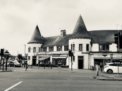
Again, a river marked the transition: this time the Crane, this stretch still unwalked after abandoning my attempt last summer. It passed under a stone-balustraded bridge inscribed with the arms of Middlesex having wound its convoluted way here from Harrow as the Yeading Brook. My memory of Cranford wasn't challenged by a new approach from the west: it remained a tired and decrepit place. The quiet and rather dull little High Street turned north, heading for the bus stop where I'd bailed out last time, while the main focus of the village had shifted here to run along the Bath Road. The parades of shops and homes, largely dating from the 1930s had intermittently been demolished to provide space for barcode-fronted hotel blocks - maybe signifying the last possible zone where a business could legitimately include 'Heathrow' in its name perhaps? At the heart of Cranford, or at least what passed for it now, the crossroads at Berkeley Parade spanned the road. Each southern corner featured a short run of local shops, adorned with a mock gatehouse bearing twin, chateau-like conical towers. Under these oddities the usual suspects traded: hair and beauty, betting shop, Halal butcher, Kebab takeaway. Between the arms of the parade, a filling station had been ingeniously nestled into the traffic island, but had now become an inexplicably 'American' car wash. On the northwestern corner of the junction, the Berkeley Arms Hotel mimicked the towers and turrets, taking them up a notch towards the grandiose, despite now functioning as an adjunct to the massive new Doubletree by Hilton next door. The final corner was left to a scrap of grass, untouched by a housing development which had crept towards the crossroads but given up short. Perhaps this unkempt litter-trap was a vestige of the cherry orchards which once edged down to the Crane before the building boom of the interwar years? Maybe this was the only authentic spot to be found at this weirdly deceptive way-station on the Great West Road.
I wasn't sorry to leave Cranford, despite an acute awareness of my need to return at some point to complete the navigation of the River Crane. Departure also necessitated a crossing of the interminably congested and treacherous 'Parkway'. This relentlessly busy north-south route had grown in importance beyond its design, cutting off a useful corner between Heathrow and the M4 and linking to the northwestern suburbs more directly than any of the more major routes. This fistula between the quadrants was a remnant of the Ringways plan, but benefited from none of the associated engineering - thus it was a channel of broken glass and decaying memorial flowers. There was no pedestrian provision for the trajectory I was taking. A subway portal leading to the south-western corner of the roundabout was the only viable option for walkers. Instead I had to chance the ebb-and-flow of the traffic, negotiating with drivers slowing for the turn, or speeding away from it. Waggoners Roundabout was named for the Jolly Waggoner, a long-standing staging post on the road out of London which was now an Indian restaurant, along with an opportunistic and fairly basic offer of rooms for the confused traveller taken in by their website's 'near Heathrow' or 'minutes to Twickenham stadium' spiel. Neither of these claims, ambiguous and inaccurate as they were, compared to the bare-faced audacity of claiming that it is well-situated for 'the best of Hounslow'. A trickle of guests left for their long circuit to the airport entrance or today's Rugby international, shoulders slumped, composing their TripAdvisor reviews as they rubbed sleepless eyes and worried about making their flights. Beyond this forlorn spot, the northern flank of the A4 rather suddenly gave way to farmland, save for an impromptu airport parking concern which had set up camp on the fringe of the field. While my route would pass a few streets from areas of parkland, this was my last chance to get close to nature from the pavement so I savoured it carefully, This was a tiny corner of the vast tract of Hounslow Heath which once straddled the routes into London from the south and west, providing campsites for armies and cover for cutpurses since time immemorial. Now, the suburbs had swept in like a tide, leaving a litter of low-rise former council houses in their wake. But these ancient arterial routes are defined by their wayside taverns, and at the next junction the textbook transformation had taken place: the huge mock-tudor 1920s Traveller's Friend with its towering brick chimneys and multiple gables had morphed into a McDonalds.
I've written before about these sprawling interwar public houses along the routes into London, perhaps incorrectly describing them as 'roadhouses'. There certainly are many such places on the trunk roads of Britain, but these earlier arrivals on the scene are more properly termed 'improved pubs'. As the era of motoring for leisure and business dawned and the UK road network began to expand into something close to its current shape, many tiny and old-fashioned drinking establishments along the way received huge investment from the brewing industry. This was a conscious attempt to lend some respectability to drinking places, adding restaurants, opening up the lounge bar and displaying a grudging acceptance of men and women drinking together. However, there was always something a little louche about these places - located out-of-town, often in suburbs which hadn't yet quite solidified around them. They were places not to be seen, where exotic entertainment thrived and where the serious business of boozing played second fiddle - a shift which would continue as the century wore on. In some ways they led successive waves of suburban architectural style: in the 1920s 'tudorbethan' was popularised by the rebuilding of old inns in the style of The Traveller's Friend here in Hounslow. Later, as the roadhouses emerged along the new dual-carriageways which scythed across once open country where there were no older pubs to improve, it was in the Moderne style: smooth concrete and steel for a new, streamlined world. Here at Henlys Roundabout, roads both old and new converged: my route in from the west met the end of the A30 - the Great South West Road which began its long journey to Exeter and Land's End, remaining remarkably faithful to the ancient tracks recorded by John Ogilby - His Majesty's Cosmographer and Geographic Printer - in the 1675 Britannia Atlas. The old road to London continued ahead taking a straighter route than mine, but snarling and stalling into Hounslow's town centre. Instead I struck out along the new Great West Road, built in 1925 along a straight alignment through largely open countryside. The road east still felt broad, modern and optimistic, despite the presence of towering digital billboards hired by an organisation called 'Brexit Express', urging drivers to 'Take Back Control'. Brexit haunted these approaches to London. It was impossible to escape the impending sense of its coming, but like a traffic jam on the A4 no-one quite knew when it would arrive or what we'd find at the end of it.
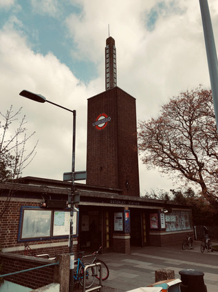
Suburbia had encroached on the stretch of straight new road which I was now walking, enclosing it in a halo of comforting banality after the nerve-jangling junction crossings I'd navigated. This area between Heston and Hounslow was slow to develop, with the Hounslow & Metropolitan Railway passing by from 1883 but taking a deep swing to the south, and leaving the pattern of tiny villages and lanes here until well into the last years of the 19th century. The tiny hamlets of Sutton and Lampton were removed from the map gradually, but surely. Their names captured and surviving only in side-streets, parks and schools. The clusters of shops around the former village centers had in each case become a hotel - Sutton had the Master Robert, a fine old 1930s pile, at least until its demolition for a much debated new Ibis Styles. Meanwhile the imposing, grey slab of the Park Grand rose over the road at Lampton, claiming only moderately dishonestly to be ideally situated for Heathrow. It was in the same general quadrant of the map of course, but this could be a world away from the security cordons and perimeter roads of the airport, which felt like they were in another territory entirely. The pavement stretched ahead, the horizon only broken by the curious concrete totem atop Osterley Station. The station building was reconstructed abbutting the Great West Road in 1934, replacing the former Osterley & Spring Grove further to the east, near to the grand Thornbury House and little else. The brick tower and concrete spike looked like a lightning-rod drawing the energy of those interwar years of municipalism. It was the work of Stanley Heaps - who became Chief Architect for the Underground on the early death of Leslie Green in 1908. Heaps' presided over the introduction of escalators to stations from 1911, designing the first stations specifically constructed to use them by adapting the archetypal two-storey oxblood terracotta tiled design which Green had perfected. Heaps' tenure also overlapped with the great Charles Holden whose streamlined, modernist designs for the City & South London Railway extension (now the Northern Line) had been selected in preference to his own rural pavillion-style buildings by Frank Pick. While Holden was commissioned to work on many of the numerous new stations constructed during the 1930s, Heaps tended to take on the minor projects and lesser-used extremities of of the network. Hence, his futuristic and imposing building at Osterley soars over the low-rise suburb, more like a modern estate church than a transport nexus and with a knowing nod to Holden's style. The railway was extended to new stations serving the growing town of Hounslow and eventually to Heathrow Airport, but Osterley remained a rather drab and quiet place. Beside the station was an abandoned bridge crossing over the tracks but heading in completely the wrong direction, wide enough for a line of traffic but grassed over with access only on foot. A glance at a historic map had this crossing here from the outset in the 1880s: a sturdy and remarkably well-made structure carrying only a farm track between divided lots of land. It survived rather miraculously beside the Underground station and the shuddering traffic - a bridge to nowhere surrounded by modern suburbs and hemmed in by busy railways and roads.
In so far as Osterley was a real place, it didn't extend far beyond its eponymous Underground connection. Away from the road, removed from the suburban sprawl in a large tract of parkland stood Osterley Park, built for banker Sir Thomas Gresham in the 1570s following his purchase of the manor of Osterley, this impressive Elizabethan pile was one of a ring of fine manor houses which would once have felt remote from London. The brick tower of the station felt like a modern, single-fingered salute to the great city dynasties, and beyond it the Great West Road returned to suburban mundanity. Comfortable villas rested behind service roads, cycleways and barely-used pavements, some of their stones cracked by the swift turn of vehicles onto driveways. The mock-tudor theme was carried into the Osterley Park Hotel, a sprawling while building with just too much of a hint of Fawlty Towers about it to be entirely convincing. The carpark was surrounded by the kind of low-rise motel blocks which belonged on a Midwestern Interstate. This place shared all their downtrodden sleaze and none of the romance of the road. It was hard to forget at this junction, that the Great West Road was once the height of modernity - a hopeful, gleaming stretch of pristine factories stretching towards London and manufacturing the newest things: wirelesses, disposable razors, processed foods. The white-heat of early-20th century progress had played out along The Golden Mile, before being cruelly cut short by World War II and the following austere years where consumption was regulated, and luxury impossible. The change in tone began in earnest at Gillette Corner, where Syon Lane crossed the road at an oblique angle, allowing a wide sweep of land to wedge up against the road. Here, in dark brick and great sweeps of steel-framed glass, Sir Banister Fletcher Jr's imposing and vast Gillette Building glowered across the cement plain of the suburbs. Atop its stacked, churchlike tower a copper cap and an illuminated clock still radiated progress and modernism despite the decline of industry in the surrounding area. Now at risk of redevelopment as a business park and residential zone, the building is at least listed. Other examples of classic commercial and industrial architecture hadn't fared so well here. Not least the once equally mighty Firestone Building, designed by Wallis, Gilbert and Partners and finished by 1928 and modelled on an Egyptian temple. The style was then rather jauntily known as 'jazz moderne' but later more familiar as Art Deco. The Firestone Company ceased using the site in 1979, and the area was threatened with dereliction. Minded to save the impressive building, Michael Hesletine at that time Environment Minister, intended to list it. A tip-off to the developer, commonly thought to be from within his department, saw the bulldozers move in over the August Bank Holiday weekend of 1980, and the building was gone save for the striking perimeter wall topped with decorative lamps. In some senses, this destructive and needless loss saved much Interwar architecture, with Heseltine swiftly moving to protect the Hoover factory and Battersea Power Station from demolition. But the loss was great, and the Golden Mile still bears the scars. The roll-call of consumer products and technological marvels which were once manufactured here seems mundane now, but would have been groundbreakingly futuristic: cosmetics and toothpaste, radios and gyroscopes, cars and fire-extinguishers. The statue of a sylph-like diver wasn't replicated atop Jantzen House, the inert modern residential block nearby named to memorialise the knitting mill, and the aroma of baking and hot sugar no longer emanated from the biscuit factory. In fact, on a windy Saturday the Great West Road was eerily quiet. A few cars nosed carefully into the traffic as they exited the Syon Clinic, a private healthcare facility which now occupied the former Coty factory, and the turning-lane bore the tyre-marks of heroic spins across three carriageways of traffic to access the HQ of Sky TV. The road was quiet though, its best years long behind it and a faded glamour only barely showing through the grimy, smoked glass fronts of modern offices.
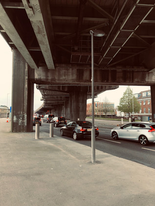
An almost imperceptible dip in the road heralded the crossing of the River Brent. I had passed under this bridge on my last visit, almost entirely unaware of the road above except for its reflection in the flanks of the Glaxo SmithKline offices which snaked along the river as it plodded sluggishly towards the Thames. There was equally little trace of the former GWR railway line which crossed above the road here on its course towards Brentford Dock - an ill-starred and poorly used line which has remarkably survived for carriage of aggregates and refuse, now curtailed to a terminal north of the A4. Crossing the Brent felt like a reconnection, a sense of tying what had been a disconcerting and alien walk so far into my existing map of London. I was grateful to the persistent river for the familiarity and the context, as the Great West Road was a disorienting companion: modern but faded, broad and fast-flowing but now rather strangely empty of traffic. The reason for this quieter passage was nearby: curving in from the northwest following a crossing of Osterley Park which would surely never get off the planner's desktop nowadays, the M4 advanced on concrete stilts towards its predecessor. Edging ever closer, I watched the flash of metallic paintwork along the viaduct until it disappeared: the road was now above me, the massive buttresses which supported it marching along the central reservation. The air darkened, sunlight blocked by concrete and particulate pollution. A light rain began to fall, stirring up a foul traffic-tainted petrichor. I amazed myself by thinking suddenly and clearly that this did not feel like a good place to be walking at all. I've trudged my way around some congested, contested zones in the last few years, and inhaled more than my share of exhaust gases, but nowhere within the limits of the city had felt as avowedly anti-pedestrian as this. I crossed a minor road which doubled as a cross-town rat-run, disgorging traffic onto the lower level of the intricate stitching of roads, and walked almost directly into the path of a screeching Audi driver. She looked feral: a mix of horror and indignation passing across her face at the recognition that a pedestrian dared to stray into this zone. Another car or a motorcyclist would have been an acceptable collision: they had actively voted into this maelstrom of noise and filth. But a walker? They had no business here. I was mildly amazed to find the zone so repellant because, as a wide-eyed child consuming the most elaborate motorway junctions avidly in atlases, this masterpiece of engineering had often intrigued me for lost hours on end. I was fascinated by the subtle weave of the on- and off-ramps, slipped together so the schematic overhead looked like the instructions for tying a Sailor's knot. Up close, it remained a beautifully designed thing, and behind the haze of dust and the anti-semitic graffiti, I could appreciate what I'd seen all those years ago with the eye of a cartographer, if not with the feet of a pedestrian.
But for now, surviving the passage under the M4 became the priority. The locals appeared able to turn a blind eye to its omnipresence - amazingly a run of tumbling homes and a parade of semi-open stores still fronted the scene as they had long before the Motorway arrived. Carville Hall Park was divided by the road soon after its purchase as allotments and playing fields by Brentford Urban District Council after the First World War. The house in the southern part of the park, Clayponds, falling into gradual disrepair in public ownership. It was perhaps never a salubrious site, hemmed in by Kew Bridge Goods Yard and the tarmac strip of the improved Great West Road. Today it was busy with families and footballers, the humid grime on the air apparently no barrier to sports. The road bucked north to avoid the tip of a triangle of railway land undergoing dusty and rapid redevelopment, then turned south again fringing the extremities of Gunnersbury Park. As a public park, this space dates from 1925 when it was purchased by the Boroughs of Ealing and Acton, while lying wholly within Brentford. The purchase, from the Rothschild family, was driven by a desire to keep at bay the encroaching public housing which the perhaps more enlightened Borough was busily building. The corner of the huge park closest to the A4 was soon given over to Gunnersbury Cemetery, a formally laid-out memorial garden which controversially provided a home for a monument to the Katyn Massacre of 1940, where Soviet troops conducted the murder of 22,000 Polish citizens and military officials and buried their bodies in mass graves in Katyn Forest. The black obelisk was a controversial addition to the cemetery in 1976 following considerable pressure during the Cold War to prevent a commemorative site in Britain. From the footpath, fleeting glimpses of the white stone Commonwealth War Graves flitted between the trees as the traffic howled and hooted under the canopy created by the M4. This wasn't the most peaceful resting place perhaps, but it was a world away from the grim discoveries of 1942. The traffic snarled and shuddered to a halt, tail-lamps flicking on like a red wave rushing towards me in the shadow of the overhead carriageway. I had reached Chiswick Roundabout - the launch and ending point of my long tramp around the North and South Circular Roads which was, in a sense, the precursor to this series of foolhardy walks into London from all angles. The scenery was familiar, but distorted by approach from the west. I crossed the A406 at the point I'd set off, still a mess of roadworks and confusion, and made my way around three-quarters of the vast churning traffic island. I struck out along a footpath which I'd never noticed before beside the houses in Surrey Crescent, which climbed to meet the road which soared over the roundabout. Looking back I tried to picture the scene in 1959 when Jayne Mansfield opened the flyover. The view west was still futuristic - a shimmering field of metal and glass offices and car showrooms as far as I could see. But I imagined that they'd seen the future shaping up a little differently back then in the Atomic Age?
In the middle distance, a train crept slowly out of Gunnersbury Station as the sun began to seep from behind a thunderous-looking cloud overhead. The stretch of road ahead seemed impossibly long, and frankly a bit dull. I'd entered the kind of West London suburbs I used as a proxy for years when contemplating the outskirts of the City: tree-lined, red-roofed and repetitive. I glimpsed myself in the window of a Porsche dealership, and noticed what the apparently disapproving sales staff had spotted: this guy wasn't in the market for wheels of any kind. I was dusty, sun-pink and my fading cap was pushed back on my head to facilitate the long view ahead. Chiswick seemed endless, but drew to a nexus in the angle created by the Great Chertsey Road and the A4: here sat Chiswick House - once a Jacobean retreat from London for the Earls of Burlington, rebuilt in the Palladian fashion by the 3rd Earl in 1719 following his excursion to the continent. The house had finally passed into the ownership of Middlesex County Council in 1929, following a spell as Chiswick Asylum - notable for relatively enlightened treatment of those considered by the Courts as insane. The grounds remained open to the public, but the Great West Road was very much the back entrance to the grand gardens. A little further ahead on a triangular plot hemmed in beside a Premier Inn, was William Hogarth's house. Built around the same time as the Burlington's were reconstructing Chiswick House but on a much less grand scale, Hogarth moved here in 1749 and lived here until his death. He is much celebrated in the street names surround the area, and a map from the mid 20th century even records a surprising modern-style cash-in next door at the 'Hogarth Laundry'. The house has been variously threatened with undermining by sand excavation, damaged by wartime bombing and encroached upon greatly when the A4 was widened by demolishing a number of streets to the north of the site. But now repaired and spared further indignity the house remains as a museum and an ancient Mulberry tree still stands in the walled former orchard around the house, having been carefully nursed back to health by the staff of Kew Gardens following bomb damage.
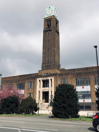
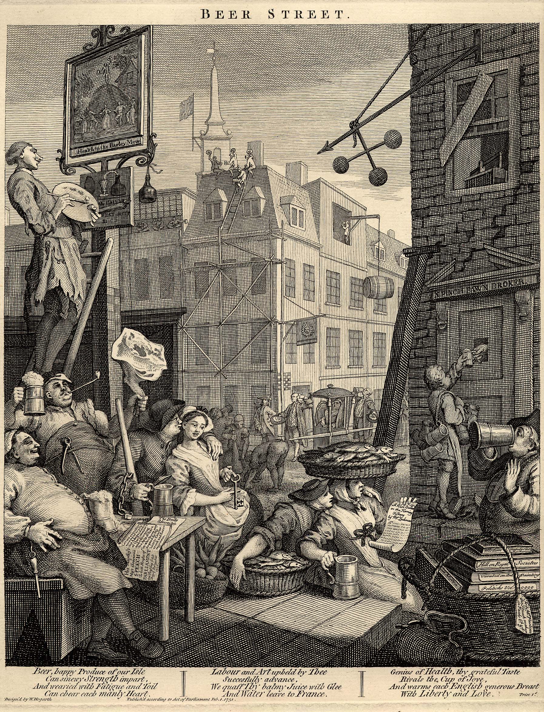
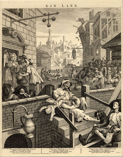
Hogarth's 'moralizing' paintings of London life are particularly relevant to this location too: his Beer Street depicting a happier, healthier population than the degenerate denizens of Gin Lane. Brewing has taken place at the nearby Griffin Brewery since the late 1600s according to Fuller, Smith and Turner - though the current brewery site began to expand after Hogarth's death, covering the green fields which he'd moved away from London to enjoy. The brewery today was a tumbling agglomeration of buildings of various vintages, stacked almost haphazardly behind a wrought-iron entrance gate. I'd visited once before, on a beery, now rather hazily remembered trip organised by a Highbridge publican. He'd borrowed a van from the local Sea Cadets and managed to score them a parking fine in a Residents Only zone, which he gleefully tossed out of the window as we screeched away homeward, bags clinking with bottled ale some of which didn't make it back to Somerset. As i walked the length of the brewery, I noted the wind rising and a marine bite on the air - the river was near, perhaps the nearest it would get on this walk, and I could taste and feel its presence. I'd briefly found myself on this stretch of road a while ago while making the crossing from Furnival Gardens, where Stamford Brook once flowed out into the Thames - once a busy working creek, until it was backfilled in 1936 as industrial use receded. Today I stayed north of the road beside Ernest Berry Webber's Town Hall building. Work started here immediately after completion of Dagenham Civic Centre and followed a similar pattern: a Portland Stone dressed lower level with red brick above in a style dubbed 'Swedish Georgian'. The impressive southern face of the building contained offices and a suitably forbidding entrance to the Treasurer's hall, flanked by stone carvings of the face of Father Thames by George Alexander, and likely some of his final civic work. The Town Hall was extended somewhat unsympathetically in the 1970s, the three huge arched bays of its grand, northern entrance lost behind a vehicle access and a tangle of stairways linking the new building to the old, however it remained in public use having endured the passing of the old Borough to the newly extended Hammersmith and Fulham in 1965. The street which ran the length of the building was named Nigel Playfair Avenue, in honour of the actor-manager of the Lyric Theatre. Originally located on Bradmore Grove but now operating in a modern building a short distance away, the auditorium was dismantled and reinstalled when the original premises was threatened with demolition in 1966. Playfair's exploits had previously been celebrated by other streets around the Town Hall, including Nigel Playfair Road and Macbeth Road - both obliterated when the Great West Road was extended towards the West End via the Cromwell Road Extension, which brought my route to the very doorstep of the City.
Plans to extend the Great West Road further into London had existed since the completion of the section to the Hogarth Roundabout in the 1930s. The planned route carved through Hammersmith, cutting into residential streets and gardens, and proved deeply unpopular. Instead the A4 decanted traffic unceremoniously onto the Broadway, clogging the busy junction between the two Hammersmith stations, before sluggishly stop-starting along Kensington High Street towards Hyde Park Corner. The Second World War throttled progress, but in the bold, post-war age of concrete and interventionism, a new plan was hatched for a slender flyover skirting the edge of Hammersmith on stilts to link the Great West Road with an upgraded continuation of Cromwell Road. The winning scheme was designed by Marples, Ridgeway and Partners - at the time still partly owned by then Transport Minister Ernest Marples who then scrambled to sell his shares via his partner. Soon after, the company secured the contract to build both the Chiswick Flyover and the Hendon Urban Motorway, despite reported lower bids being tabled by rivals. The dual carriageway would ascend on elegant reinforced concrete spans, carrying a system of heated cables which would reduce the need to salt or grit the road when ice formed. Opening in 1961, the road was already carrying more traffic than had been foreseen, but was certainly reducing delays. The heating system was also a success until the first cold snap delivered Hammersmith & Fulham a £4000 electricity bill. A tussle over payment saw the London County Council pick up the tab, but then swiftly stop using the cables in preference to regular gritting during cold weather. This almost spelled the end for the flyover, and in 2011 the whole structure closed due to serious safety concerns: the concrete cores of the pillars had corroded following fifty winters of salt and grit application. Transport for London raced to repair the strategic route in advance of the Olympic Games - money was no object when the IOC were coming to town it seems. Forced to turn aside by the flyover, I detoured briefly into Hammersmith to visit an old haunt for coffee. The knot of streets around The Broadway was pleasantly busy, the afternoon brightening as I headed east. It was soon time to return to the road for a last push into London. The flyover slowly touched-down on a windswept stretch of road between modern office blocks and hotels. I was the only pedestrian again, my progress along the semi-private stretch of pavement watched by almost pointless security cameras. Ahead, the bulky brick piles of Hammersmith and Fulham College filled what was once the playing field of St. Paul's School. In 1891, the view here had been so pleasantly rural that architect Frederick Wheeler selected Colet Gardens for St. Paul's Studios, a terrace of brick and terracotta dwellings for 'bachelor artists' which included lofty, arched double-height windows providing light and views across the fields. With Baron's Court station tucked neatly behind the studios, and a colony of artists already living nearby including Edward Burne-Jones, the well-connected location was swiftly popular with a series of young, up and coming painters. Now the studios looked over the relentless A4, a far cry from Wheeler's plan but still fetching prices which excluded even the most well-connected struggling artists.
The road was beginning to slow down, becoming a continuous line of city-bound traffic which nudged, nose-to-tail onwards. I passed over the complicated tangle of Underground and Overground lines which marked something of a boundary in the shadow of William Whiteley's Repository. Whiteley is widely regarded as the father of the modern British department store, having been inspired to become the 'universal provider' by a visit to the Great Exhibition in 1851 where he saw the wares of the British Empire laid out as if on sale. Learning the trade in the City while he forewent tobacco and alcohol to save the means to open a store, Whiteley opened his first premises in Westbourne Grove. He slowly purchased adjoining stores to assure him by 1875 of an unbroken run of shopfronts on the upmarket Queensway, from which developed a grand store in which he boasted he could sell everything from 'an elephant to a pin'. Here, beside the A4 his equally grand and capacious Furniture Depository still stood - a huge, ornate block which still dwarfed surrounding buildings boasting on its facade 'furniture and pianos displayed in mocked rooms' in a harbinger of the coming world of Ikea. Whiteley showed remarkable acumen, broadening his appeal by adding meat and poultry counters as the neighbourhood became less salubrious and more working class, but inciting the dismay of rival traders who protested his encroachment into their markets. His store was targeted by arson attacks on at least three occasions, reputedly from rivals who resented his all-encompassing business model. Whiteley's empire-building was unceremoniously curtailed by his murder on 24th January 1907, when he was shot dead at his store by Horace Rayner who claimed to be his illegitimate son. Found guilty and expected to hang despite a plea of temporary insanity, Rayner's sentence was commuted to life imprisonment when evidence indicated that the apparently generous and egalitarian Whiteley had not been quite the benefactor to his 6,000 staff which it appeared - in fact, he had been a bully and a serial philanderer. His family continued the business until 1912 when they sold to his arch-rival Gordon Selfridge, who had in recent times commenced trading on Oxford Street in his own great store. Whiteley's own palatial Queensway building remains, now an upmarket shopping mall bearing his name, while his Repository stared-down a gargantuan Tesco Extra across the railway tracks. It was hard to imagine William Whiteley not being impressed by quite how they'd packed a little of everything into the bright modern store.
A little further on, the A4 ceased any pretence at being an expressway, the dual carriageways merging into a single four-lane traffic jam between an avenue of mature trees and tall red-brick mansion blocks. This was the characteristic western suburb I'd grown to know in my earliest forays from Paddington. A little faded, but clearly still expensive and exclusive. I noted the crowds on the pavement thickening as I approached Gloucester Road station with its surrounding bloom of hotels formed from grand townhouses. The fine entrances from the street into opulent reception areas didn't convey how tiny the subdivided guest rooms were, or that there was likely no elevator available for the vast amounts of luggage just decanted from a Piccadilly Line train direct from Heathrow. It occurred to me that these arriving tourists had made the same journey as I - off the runway, over the Crane and under the suburbs to what they regarded as the 'real London'. I remained to be convinced, and while the grandeur of Albertopolis was almost enough to divert me into side-streets for better views of the sublime Natural History Museum or the Victoria & Albert, my bloody-minded refusal to get out of the way of the tourists hurrying and jostling towards me won out. I - quite literally - pushed on, into the crowd, accidentally cannoning into meanderers who stopped short to survey a telephone kiosk or some other on-brand bit of British street furniture. I realised that I'm at my worst in these areas, and that's largely why I avoid them. It wasn't outright snobbishness - more a mortal and an ever-present fear of becoming a snob. I've always been content to leave these zones to the tourists and the tour guides, let them mass on the pavement and impart stories which are far more compelling than those I rustle up from the docile suburbs. I passed into Kensington and things became even more congested and impassable. Harrods was a magnet, the looming, leering bulk of the gaudy frontage covered and under maintenance. People still snapped avidly at it, before sneaking inside for a carrier bag. The real customers cruised the A4 in high-end Mercedes and Bentleys, looking for on-street parking in the most conspicuous places possible. Beaten out by alert Uber drivers, they cursed and circled again, determined to be seen in the right car, in the right place. Here in the west, even the choice of illegal parking spot was a significant lifestyle matter. Head down, I pressed ahead to surface at Hyde Park Corner where there was at least some respite as the crowds peeled away towards Buckingham Palace. Piccadilly was a surprisingly pleasant walk, the quiet Portland Stone edifices of clubland giving away no secrets, and clearly expecting nothing of a perambulator from the suburbs. I felt at peace with my surroundings for the first time since crossing the railway back in Kensington. I was also acutely aware of the expectations on me to capture this part of the walk: people would call it 'the interesting bit' - far preferably to banging on about the marginalia. I was a poor witness though, content to let the city unravel around me as I walked back into the crowds at Piccadilly Circus briefly, before turning south onto Haymarket. Despite being the edge of Theatreland, all was quiet here: the matinees had begun, and the street would be quiet until early evening. The sun had made a break for it above me, and walking was now pleasant and warm. I looked forward to being able to get onto more familiar territory again, feeling a little lost out here in the West End. At the sight of George III on horseback, I turned east once again - the home straight was in sight.
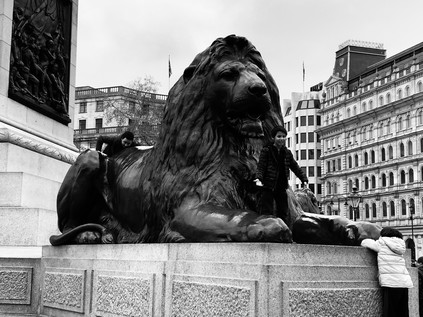
Children slithered over the backs of the bronze lions of Trafalgar Square, barely able to stabilise themselves for the inevitable picture. Pigeons swarmed, more numerous almost than people. Buses jostled end-to-end. It duplicated the expectations, like every visit here - and like every filmed moment here - always did. Strangely though, I felt charitable towards the crowds who lolled outside the National Portrait Gallery or padded around taking selfies in telephone boxes. The city they came to see was the same one I travelled to for each of these walks - it was built on an international reputation which had allowed it to become the sprawling, confusing mess which I wanted to explore and understand. Without them, there would be no weird edgelands around Heathrow Airport, no endless suburbs stretching from the Crane to the Brent, and maybe no graceful concrete arc of M4 curving in from the suburbs. It could all be so different, but their celebration of a London I barely recognised outside a Richard Curtis movie or that one, clumsy two-part episode of Friends enabled the city I visited to exist, to work, to persist. As I passed the site of Temple Bar and entered the City of London I thought back to the huge 'Taking Back Control' billboards I'd seen in Cranford. The future was uncertain, our role as a financial power in the balance. Everything built here had sustained crashes and disasters before, but this time things felt self-imposed and stupid. It felt wilful and utterly British: a national cutting off of the nose, our face about to be mortally spited. I felt a mix of pride and vitriol: that I could walk these long routes safely and free from impediment was utterly British in character, but so was arrival in a place which might just be about to undergo self-immolation. The A4 proceeded along The Strand, into the City and down Ludgate Hill into the valley of the Fleet. I should have taken a final turn into Fetter Lane to conclude my route at a non-descript junction marked by a statue of Albert, Prince Consort who might just have been the patron deity of this last section of the route. Instead, I lifted my eyes to the dome of St. Pauls Cathedral and walked on, pausing to pay my respects to the Phoenix at the South Door. A little further on, once again revealed after a long disappearance from view, London Stone was visible behind clean glass and surrounded by fresh stonework. For years I'd grown used to peering down at the edge of the pavement, through a stained, yellowish window at the nondescript lump of rock. Now it could be seen properly - an irregular calcinate loaf of uncertain age, but certainly here for centuries. This felt like a fitting place to end the walk, at the very centre of London's onion-skin of layers. The clouds shifted overhead promising a fine evening after all the glowering storminess of the day. I almost regretted there wasn't further to go. But for now, this would do perfectly.
You can find more pictures from the walk here.
Lost::MikeGTN
I've had a home on the web for more years than I care to remember, and a few kind souls persuade me it's worth persisting with keeping it updated. This current incarnation of the site is centred around the blog posts which began back in 1999 as 'the daylog' and continued through my travels and tribulations during the following years.
I don't get out and about nearly as much these days, but I do try to record significant events and trips for posterity. You may also have arrived here by following the trail to my former music blog Songs Heard On Fast Trains. That content is preserved here too.
