London Ordinal: The A2 - A Spark In Your Veins
Posted in London on Saturday 2nd February 2019 at 11:02pm
I'll start at the end... I'm in the same coffee shop which I headed for at the end of my last walk. An old haunt, a staging post on the way back west after conferences in Bloomsbury or casing the City, worrying about appearing on too many CCTV feeds. I've gravitated here repeatedly over the years because there is something comforting about being above the outflow of the River Fleet, at the end of a mysterious valley which was part of the reason I began to walk around London. It's quiet here again, I sip coffee and write, my feet buzzing with the heat of a walk completed, my calf muscles occasionally tightening unexpectedly as they relax from their exertions. When I set out on this new project, inspired by a return to the road which was in some ways unexpected, it had seemed like a simple enough proposition to walk into London from five different directions, governed only by the vagaries of the 1922 road numbering system. The spider of primary routes out of the city was strange and compelling to me - the roads struck definite, carefully defined courses from the suburbs, but blundered to indistinct ends in the centre of things. Road numbers weren't important in the heart of the old City. Destinations were close at hand: Holborn, Shoreditch, Angel. London looked inwards. It was miles out of town before the A1 gave up its first sign to 'The NORTH'. I'd also surprised myself by obeying the correct order: today I'd headed out to the edge of Kent to walk the A2 from the boundary to the centre. I realised that this locked me into an expectation of compliance with my own rules, and I somehow knew I was likely to follow the preordained pattern: walking might be an act of revolution, but I was no revolutionary. The familiar trip out over the rooftops of London Bridge towards the suburbs was relaxing and almost beautiful with the remainder of snowfall from last week lingering in sheltered spots. I'd dressed for the weather I didn't want to find, but hoped for the bright, cold day predicted. Crossing the Thames in a light flurry of powdery snow didn't bode well, however. I tightened my scarf for the walk ahead.
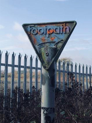
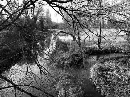
I stepped off the train onto a slushy, slippery platform at Crayford. The landscape felt familiar but was changed by the perils of the icy pavement, keeping my focus just one step ahead of my feet. I headed over the treacherous footbridge and into the backroads which led south along the railway line. I was looking for the entrance to Braeburn Park and Nature Reserve, an extensive but pleasingly unkempt angle of wilderness between the railway line and the A2 as it meandered in from Kent. I hadn't quite crossed the county boundary today: that lay further back towards Dartford, but I was as close as I could easily get as the A2 between here and Dartford was not for pedestrians. I met it instead at a low bridge over the rails, a tiny and rather forbidding path carved into the embankment and indicated by a heavily redecorated 'Footpath' sign. The area had been sequestered for drainage works, with huge tracts freshly of remediated topsoil strewn across a wide triangle of churned land. Everything screamed 'no entry' and I felt a mixture of mischief and surprise when I strode out rather confidently across the patch to find the path which hugged the railway under the bridge and then climbed to join the angry rush of traffic on the dual carriageway. This was the last chance of escape - from the road, and from my rules. Another path led away south, towards Old Bexley and the valley of the River Cray. But again I stuck to the plan and at the head of the slope found myself edging along a narrow path between the hard shoulder and the parapet of the bridge. It seemed likely that the path alongside the eastbound carriageway was better favoured, but I wanted to walk on this side, at least at first. The path soon parted from the road under a sign telling the most polluting vehicles to leave at the next exit to avoid the Low Emission Zone. Delving steeply down again into a snowy gully, I began to enjoy the challenge of the walk. The sky was brightening and any threat of new snow seemed to be passing. I was alone on the remote path despite being mere inches from thousands of motorists. I felt in my element again. Trudging slushily through the snow, I soon came upon the reason for staying on this side of the road: beneath me, the silvery waters of the River Cray were joined by the smaller River Shuttle at a busy, angular confluence. Both rivers were swollen by melting snow and ice, and their junction glistened through the tangle of wintry branches below. Like all confluences, this felt like a significant moment. It had been hard to walk near the Cray on this part of its journey, and these last metres of the Shuttle were almost entirely inaccessible. Passing over the Cray here linked me to previous endeavours and added another junction to my mental map of these south-eastern reaches of London which had been a relative mystery until recent years. I moved on, crossing the complicated loops of the Black Prince junction, the Shuttle now in an anonymous concrete culvert beside me and relegated to the role of a drainage ditch for the hotel site. The Black Prince was now a chain hotel, its mock Tudor facade fronting a quadrangle of more recent and less showy low brick blocks, ideally situated for the commercial traveller breaking a journey on the road to Kent, though it was unclear how many did so nowadays. Named for a supposed haunting of nearby Hall Place by Edward of Woodstock who rested there on route to war in France, it was also a staging-post in the career of another Edward: the late Prime Minister Heath who bunked here during his campaign to be elected MP for Bexley in 1950. The slip-roads swirled around the faded hotel as I returned to the road with the River Shuttle beside me, for a little while at least. The alignment of the route used the floor of the valley created by this tiny river to give it a flat and broadly straight route west. I stayed close to the rush of traffic, my route varying from slippery, frost covered footpath to a secondary service road serving the decent, large villas which lined the A2. The sun was climbing over my shoulder and the day was shaping up to be remarkably bright given the conditions I'd prepared for. I struck out at a surprisingly brisk clip, enjoying the walk.
The A2 is a bypass of an ancient route through Kent, which since the 1930s has taken a far more meandering route than the direct, Roman road which ran a little way to the north. The advantage of this southern course was avoiding the steep ascent of Shooters Hill and the passage through the challenging darkness of the woods which blanketed the climb. Between these old and new strategic routes was the broad commuter-belt swathe of Bexleyheath, with its shopping centres and carparks which I'd picked my way across when negotiating Watling Street. I crossed the current route at a footbridge, going against my usual practice: I usually walked with the traffic, preferring the gentle swish of cars passing rather than the unsettling flood of headlights apparently careering towards me. I'd fathomed from very cursory checks that the route might just be easier at the Danson Interchange if I was on this side of the street. In practice, there appeared to be very little to choose with both footpaths requiring a scurry down to the A211 via a staircase, before ascending and reappearing in a narrow alley running across the front of homes otherwise marooned by the highway, widened considerably since building at the cost of their front gardens. The sheltered footpath was still strewn with snow which the sun hadn't yet reached which concealed a carpet of frozen litter tossed from passing cars, and I picked my way along carefully meeting only a postman and an agitated man twitching his way home urgently accompanied by the telltale clinking of a blue carrier bag. I passed the grey reverse sides of huge roadsigns which dwarfed the suburban street furniture around them, casting long shadows in the wintry sunlight and filling the views from the homes along the route. I'd found my stride and I was walking at a fair pace now - but London still felt improbably distant, the long tarmac strap of the A2 slowly unwinding towards the remote city ahead. I surely couldn't reach the centre of things in one walk, could I? Thankfully at least, the house numbers were increasing: there is perhaps nothing so disturbing as realising that the properties alongside a long route are slowly counting down from some currently impossible total, the walk becoming an endurance test. The road continued in its deep trough between the rising woodland of Danson Park and the suburban hinterlands to the south. This clearly wasn't going to make a great story: it was just an arterial route into London, seemingly unremarkable in every sense. There appeared to be few secrets to uncover as the road ploughed onward, arrow-straight and apparently endless, passing the mysteriously named village of Blackfen and pressing on towards Falconwood. The names of these settlements along the route hinted at a less prosaic past buried under the asphalt skin of the road: a history of settlement reaching back into the Bronze Age. At Falconwood my route accidentally diverged from the current A2, threatening instead to follow the line of the 1930s bypass towards the foot of Shooters Hill. I was momentarily wrong-footed by this little nexus of bridges crossing roads and railways, confused by the need to navigate back to the road having barely realised my path was parting from it. A footway through the northern section of Eltham Park led away from the station, but staying true to my purpose I turned to cross the bridge again, passing over the tide of traffic and slithering on the icy pavement which hadn't yet seen sufficient foot traffic to see off the slippery covering of the last few days. As I trudged along a high, narrow causeway above the road I gazed rather enviously across at the tangled trees of Eltham Park North, climbing towards Shepherdleas Wood, and beyond to the peak of Oxleas Wood. A road not unlike this could have put paid to the whole sweep of green I was surveying - indeed there has been an almost indecent interest in ploughing across this ancient woodland and high ground at various points: Ringway 2 would have swept in a little way to the west, while the approach roads for an unbuilt East London Crossing linking Beckton with Thamesmead would have taken an even more direct route through the spot where I was standing. It was hard to understand why this area was so prone to these schemes: the terrain here is far from easy, the rising and falling land between the A2 and the Thames presents challenges of both terrain and contour. Perhaps it stemmed from an unconscious need to tame Shooter's Hill? The old haunt of pagan Britons, murderous thieves, Droogs? The road into the City shone in a surprising burst of sunshine while the dull grey trees, shorn of foliage glowered back at me from the woods to the north. As I surveyed the frosted green carpet of Eltham Park South with distant houses rising from the misty edges of the field, it was easy to be persuaded I'd taken the right path...
Just as the day began to wane and darken, O'er the high hill, which looks with pride or scorn Toward the great city. - Ye who have a spark in Your veins of Cockney spirit, smile or mourn According as you take things well or ill; - Bold Britons, we are now on Shooter's Hill!Lord Byron - Don Juan, 1818-24
Now curving to the north-west, the new course of the A2 continued. Opened in 1985, the Rochester Way Relief Road was a bypass for the original bypass. A desperate attempt to keep the traffic flowing around the congested ventricles of south-east London. Now mired in suburban sprawl the once broad and open arterial route was hemmed in by development and plagued by snarls around junctions with side-roads. Providing a good, straight road into the city which bypassed the slog up the hill had been counterproductive, producing new and heavier flows of traffic along the road in from Kent. The new road provided opportunities for rail too, consolidating the former Eltham Park and Eltham Well Hall stations into a single, modern facility on a raft above the new road. The two stations had been close together - within a few hundred yards of each other - both located on side-streets which weren't close to the local amenities of Well Hall Road. As I skirted the chasm containing both road and railway in a narrow but pleasant strip of landscaped greenery, I passed the site of the former Well Hall station, a fine old building on Westmount Road which had seen better days, but showed signs of regeneration as a pottery shop had opened in one of its flanks. The remaining parts were 'to let', the 'Station Parade' lettering rusting on the gable. It had still fared better than Eltham Park station which had been entirely swept away by the new road. The replacement station was approached by a broad shared cycle and footpath which descended into its wide forecourt. The station was housed in a slightly gloomy but surprisingly large red brick building which had all the hallmarks of British Rail's 1980s penny-pinching despite its unusual size, and which would have of course not been justified anywhere outside of the metropolis in those austere times for the railway network. Buses ticked over between trips in the adjacent forecourt while a train shuttled back towards London, passing the site where an intoxicated driver had derailed a train killing five passengers and himself in the summer of 1972. I exited onto Well Hall Road, a decent selection of shops attracting me in to find sustenance. The area felt pleasantly busy and quietly confident. Up ahead, rising towards the foot of the hill I could see the road converging with the South Circular at a point I'd needed to take a similar comfort break when I made that circumnavigation. I didn't realise then that Well Hall Pleasaunce was so close at hand. This impressively kept range of gardens is on the site of the long-since demolished moated manor house of Well Hall. The last remnant, a fine Tudor barn thought to date from 1523 remains on the grounds, once owned by William Roper and his wife, the daughter of Thomas More. The gardens today were an exercise in careful re-creation: proud black wrought-iron gates adorned with the crest of the former Borough of Woolwich opening onto formal tiers of rosebeds and fountains, surrounded by seats and steps to other parts of the garden. It was remarkably easy to find oneself following a path which led only to a secluded sector of plants and benches, with no way out except to retrace the same route in. Well Hall Pleasaunce did, however, have an open public toilet - a rarity in this corner of London and very much appreciated. Once suitably refreshed and free of the curiously difficult to escape gardens, I turned west again along Edith Nesbit Walk. This rather gloomy path between graffitied gardeners' lock-ups and the concrete retaining walls of the A2 was named for one of the first authors whose name I'd sought out on the spine of a book. After reading The Story of the Treasureseekers in school I began to frequent the library in hope of finding more books by the mysterious E. Nesbit. She was, perhaps, the first author who I felt had treated me seriously and trusted my imagination to deal with a real-world altered by fiction. Her stories may seem trite by modern standards, and many of the tropes - most especially the group of self-reliant child protagonists cut adrift in an adult world - have been reinterpreted endlessly by children's authors in the century or since she wrote. But as a bookish child lacking friends in the late 1970s, I found an escape in these stories of magical realism through which I can track a lineage to my reading today. Even now there is always a journey, always an engagement with a bewilderingly altered world. Walking this cycle path beside the elevated road, gaining on another familiar junction with the South Circular, I felt like I was in a unexpected little adventure of which perhaps Nesbit would have approved?
Once across the psychological but largely inconsequential barrier of the South Circular, the geometry of the A2 began to change. The road here was of modern construction, cutting across the flank of Kidbrooke on a dead-straight alignment until it reached the village where it bucked and reared, suddenly turning northwards. I navigated the footpath which hugged its eastern side, dipping down into a green tunnel where underpasses linked the venerable settlement of Kidbrooke with the remains of its once-proud village green. I've written before about this rather forlorn corner - one of the few places where the brave but foolhardy plans for a city encircled by motorways actually came to pass. The Ringways haunt my suburban walks. Their absence is coded into the blighted strands of property and the convoluted junctions where lesser tributaries take up the slack of a road which could once have been. Modern wisdom counsels against the cruel concrete lanes which would have torn through now gentrified Victorian suburbs, and it's fair to say that life alongside the elevated carriageways of Ringway 2 which would have formed a complex, swirling junction here would have been unutterably grim as traffic levels swiftly exceeded predictions. But as an enthusiast, it's impossible not to wonder how this might have changed the edges of the city? As I passed under the road once again, surfacing close to a spot I'd passed while on my largely aimless walk towards Shooter's Hill last summer, I realised that this was still a nexus of routes. Up ahead at The Sun In The Sands, the ancient Roman route to Dover and its two attempts at a modern bypass converged. First the chasm of concrete carrying the current A2 was crossed by Rochester Way, its early 20th century arterial cousin, and then at a spot marked by vast flickering electronic billboards set against a grey sky, the ancient Watling Street plodded in from the east. Following the traffic, I took climbed slip-road to the west, leaving the main road to continue as the Blackwall Tunnel Approach Road as the spindly pylons of the O2 peeked above the range of new development which cluttered the horizon. The battered but extant public house from which the junction took its name still stood, a traffic-smeared presence across the highway. The sunlight which had temporarily slipped behind low, snow-bearing clouds began to filter through the crystal atmosphere of the wintry afternoon. The traffic turning west shuddered almost immediately to a halt while I shuffled by, my feet starting to drag a little as the A2 was summarily demoted from a motorway-standard road to a townhouse-lined high road. Up ahead, the view to the south opened out across the broad and misty expanse of Blackheath. Shafts of sunlight pierced the clouds, picking out the tiled roofline and church spires of the village which clustered around the railway station. The traffic progressed sluggishly beside me, occasionally surging forward before stopping again - the occupants of various vehicles becoming embarrassingly familiar as we gained on each other repeatedly. There was, for the first time since I set out from Crayford, more human traffic too. Couples wandered by, deep in conversation and wrapped for the cold. Cars decanted children for birthday parties. The heath was flecked with walkers and tourists heading for the sights of Greenwich. I'd passed an invisible boundary into Inner London - a slippery entity to define in official terms, but in my experience it was simple: it was the part of the city where it wasn't strange to be found walking.
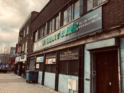
It was hard not to be charmed by the passage across Blackheath. The cold, bright afternoon was perfect weather for walking here, and the clouds which were shifting gradually southwards made for a dramatic backdrop. To the north, the land fell steeply away towards Greenwich and the Thames, with the classical facade of The Rangers House incongruously facing down the distant silhouettes of the Vanbrugh Estate. The house was built around 1723 for Vice-Admiral Francis Hosier during his remarkably youthful ascent through the ranks of the Royal Navy. In 1816, the house was first used as the home of the Ranger of Greenwich Park, its first inhabitant thus being Army reformer and imperial campaigner Sir Garnet Wolseley, the model for the 'modern Major-General' immortalised by Gilbert and Sullivan. From beyond the river, the caps of the shimmering silver towers on the Isle of Dogs radiated light back towards me. The road narrowed and twisted along older lines still, descending Blackheath Hill into the valley of the River Ravensbourne. I plodded on down the hill, heading towards the Thames - a relatively nearby prospect now, and in truth despite my land-bound route into London, it had never been far away. There was evidence of decay here in the windowless holes above closed shops and ageing signs offering the once-revolutionary 'Internet Access' - but there was rebirth too. Near the point where the snaking elevation of the DLR twisted around the sluggish convulsions of Deptford Creek, new towers were rising from the flat bottom of the alluvial valley with the obligatory empty retail unit at ground-level to create the all-important 'mixed-use' planning designation. There was a sense of the maritime here too though, a rougher and saltier edge to the estuarial accents yelling religious messages across the pavement in Deptford High Street. So much had changed, but so much hadn't for centuries. Just streets away Christopher Marlowe had met his end for 'the utterance of divers malicious words' - and with the resurgent tide of knife crime now dogging the city, perhaps London was again reverting to type? Deptford felt like a haven of normality though: closed pubs promised reopening, and old buildings found new purposes. The tall Victorian blocks which clustered along the A2 were faded and soot-marked, but they felt like a suburb of London should. The temptation to linger was strong, but the road had a way to go before it ended... At least I thought so - because yet again I realised I didn't really know where it ended. I flicked up the map on my screen, tracing the green line in from Kent, through Greenwich to Deptford, and then to where? The numbers disappeared in the tangle of Central London, the destination more important than the detail. I struck out along the long, shallow curve between New Cross and New Cross Gate - a vague sense of familiarity from a brief and anxious trot between railway stations once before, and recognition of a vast Sainsburys megastore where I'd bought one of the last few Mother's Day cards I'd ever send. The area felt vibrant and busy now, largely due to the presence of Goldsmith's in a string of buildings along the southern side of the road. In truth, was perhaps the A2's last desperate grasp for relevance. Beyond New Cross, the road managed to skirt the settlements which grew along the artery into London: Peckham lay entirely to the south, beyond the queasily cantilevered overhang of its modern library, Walworth straddled the road to Camberwell at the other extremity of Burgess Park. The roads in the south defied logic - those which would seem most important or deluged with traffic playing second fiddle to a tissue of capillary routes fanning between them. The traffic here ran between the suburbs rather than along the spokes of the city. The Old Kent Road was a drab, transient strip-mall of the kind frequently found in the United States. Little bursts of commercial activity stalled quickly, once busy shopfronts turned into evangelical missions and churches. The retail hangars arrived early in this quarter, empty lots being snapped up by B&Q, Homebase and Staples in early red-brick incarnations dating from the 1980s and 1990s. Drive-through takeaways now symbiotically populated their carparks. On the pavement, a string of Southwark Council funded advertising totems implored passers-by to sign the petition to get the Bakerloo Line extended along the Old Kent Road on route to Lewisham. There were, of course, counter proposals to ensure it came nowhere near the cursed tarmac of the A2. I walked a marginal zone, between the ambitiously devout Holy Ghost Zone and the scrapyards, alongside the vast flank of warehouse-sized DIY stores to the string of backstreet newsagents which inexplicably found themselves fronting the major route. It was unedifying walking: an ill wind blew along the road, almost taking my cap back to Kent. I switched it for heavier woolen headgear, not yet ready to let the chill of February into my skull. My feet dragged - and I was unsure if it was the long walk in from Crayford or the resistant drag of the gloomy route? This road had almost killed film-maker Andrew Kötting, his lost days and recovery from a motorcycle accident near here providing the unifying narrative of Iain Sinclair's London Overground.
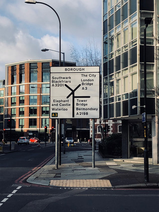
And then, the road finally gave up... At Bricklayers Arms, the carriageway parted and a concrete ramp slung traffic high above the surrounding terraces and the patch of green in the middle of the gyratory. The dominant flow was south-west to south-east, avoiding the city entirely at least from this awkward angle. Vehicles sprinted towards Brixton and Elephant & Castle, leaving the road into the City oddly quiet. I circled the junction, heading for the A2 exit which was now barely signposted and swiftly dwindled to a two-lane avenue between trees, quiet and flanked by London County Council era public housing and more recent student accommodation. For the first time in miles, perhaps even in the months since the last walk of the summer, I could hear birdsong above. The afternoon glow of the golden hour was descending on South London and the brief wintry blast of the last few days appeared to have been entirely dispelled save for a biting wind from the river. The A2 here was a spent force, only good for pilgrims making the last drag of bloodied feet towards the gabled inns of The Borough. I made my own last drag towards the crossroads where St. George The Martyr surveyed the junction of the A2 and the A3. At the moment of contact, where my route finally ended, the bells struck three - a mocking rejoinder, and a reminder that this project was barely even begun. The road in from the South West seemed long and impossible, longer even than today's slog from the icy wastes of Crayford into the gloomy, cramped terraces of Southwark. Here, perhaps more than anywhere along this ancient route in from Dover and Canterbury it was possible to picture highwaymen rubbing shoulders with penitents and pilgrims. Perhaps it was the shuffling tourists seeking the wineries and street food vendors of the market, or the heads-down weekend commuters dragging their tired feet towards London Bridge station? In the shadow of The Shard, always more impressive from a distance than beside its awkward, glassy bulk, I turned away from the A2 and faced the City at last.
My last few yards were challenging but rewarding: though my feet begged for a pause, I couldn't recall ever crossing Southwark Bridge before. The quiet route over the river was surprisingly narrow and almost entirely free of pedestrian traffic. It has always been the quietest of all the crossings, based on a flawed endeavour it was opened as a public toll bridge in 1819 when the neighbouring London and Blackfriars Bridges were already free of charge. By 1864 the owning company was bankrupt and the crossing transferred to Bridge House Estates and made toll-free. A century after the original opening, the current bridge was built - but the habits of Londoners change slowly and the bridge remains a backwater, often used for filming or as a diversionary route. The Thames gleamed in the last gasp of low sunlight, reflecting the clear, blue skies which had churned with snow and sleet just hours before. I touched down on the north bank, feeling my range anxiety dissipate almost immediately as I zig-zagged along familiar routes to Dowgate Hill and up the Walbrook's shadow-estuary towards Cannon Street station. This walk in from Kent had seemed impossible at times: a long, frozen canyon from the south and east which appeared to have no secrets to give up. However, it had been a surprisingly engaging journey. An unwinding of the onion-layers of London via a precise incision, and a salutary reminder that plans and schemes to permeate the city by new routes rarely ever worked - however hard the planners planned and the builders constructed, the pilgrims would always progress by the oldest of ways into London, patterns unchanged for millennia. Even though it was just their ghosts and I walking the last few yards of the road towards the river, the proud past of the Great Dover Road was undimmed by it's current infirmity. There was a sense that glory lay at the end of the street - whether in the old stones of Canterbury or across the water in a swiftly receding Europe.
A gallery of images from the walk is here.
Lost::MikeGTN
I've had a home on the web for more years than I care to remember, and a few kind souls persuade me it's worth persisting with keeping it updated. This current incarnation of the site is centred around the blog posts which began back in 1999 as 'the daylog' and continued through my travels and tribulations during the following years.
I don't get out and about nearly as much these days, but I do try to record significant events and trips for posterity. You may also have arrived here by following the trail to my former music blog Songs Heard On Fast Trains. That content is preserved here too.
