Not Afraid of the Dark: The Old River Lea
Posted in London on Saturday 29th September 2012 at 10:09pm
There is a fairly certain sense to my London wanderings, built around a particular set of trains and a surprisingly uniform pattern of travel. I haven't, in the main, set out to do this consciously - more it's a mixture of necessity, comfort and the repeated urge to walk certain paths. In part this has been down to a sense of impending change to the structure of the area or the looming denial of access necessitated by the Olympics. However, today was different on many footings. Firstly, I was arriving from Marylebone having spent the previous evening at the London Palladium seeing bands. This in itself was a strange take on London, with me having to negotiate the less than loved West End. Secondly I was very conscious that my mind was elsewhere today - an ocean away in fact - and that my focus was dominated in a far from unwelcome way by influences elsewhere. Oddly though, this dazed and planless situation led me to familiar territory - and after a winding and surprisingly warm sun-drenched journey atop a No. 30 to Hackney Wick, I found myself touching down on Eastway - resuming the lost threads of earlier walks which seemed to unravel in the incomplete traffic interchange.
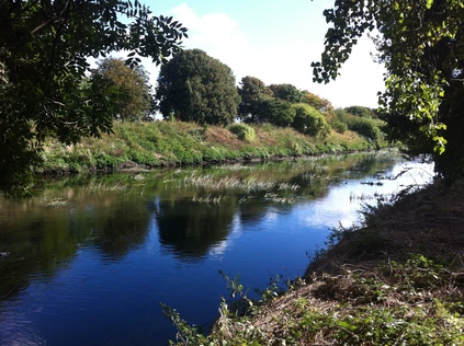
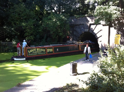
This meant initially managing the mess of pedestrian facilities at the end of Ruckholt Road once again. I dashed across, uneasily eying a pile of memorial flowers in the circumstances, before discovering that the route I'd picked my way along before was stopped up - a barrier pointlessly cable-tied across the path with no obvious purpose. I had to turn back and make an increasingly fraught set of dashes across roads of uncertain priority. The last one took me uncomfortably close to the decaying flowers, but suddenly and unexpectedly I came upon the continuation of Homerton Road, and beside it the slope down to the course of the Old River Lea. The history of the river in this area is complex - with channels being opened and dammed, made navigable then abandoned. But this ancient course persists despite falling on hard times more than once in the last millennium - a sluggish, curling, snake-like presence which defines the eastern edge of the vast and dizzying space of Hackney Marsh for much of its length. Once on the official path I quickly realised that the river was hugged by an unofficial path which ran close to its western bank. This well-worn trail was almost silent, occasionally frequented by dog-walkers roaming off plan, or by fishermen - but usually oddly silent beyond a screen of trees which eventually became a thick tangle of woodland. I set off, dodging the odd encampment of blue bags and burnt logs which indicated recent, if provisional, occupation. It was quiet and cool at the waters edge and I found my way to a quiet spot near a stopped-off bridge bearing the ODA's "Changes" notice which now looked forlorn, damaged and inconsequential. However, the changes it wrought were still real enough, as at the end of the bridge was East Marsh. Now the Eton Manor Transport Hub - a temporary facility now being inelegantly removed and restored against all good advice. Still this process confounds and destroys, even after the last javelin has been thrown.

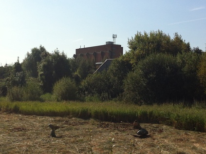
I wait at the bridge, take pictures and with a desperation and enthusiasm which catches my still bleary-eyed self off-guard, read the latest transatlantic tract. Cheered beyond reason, I move on - the river cast in a new light as a channel of hopeful emerald, swinging to the west and skirting common land - Lammas Land no less. Ancient and open by statute, but today occupied by a loud, howling tannoy as part of the Countryside Live event. I can't imagine any speck of wildlife for miles around tolerating the keening noise of feedback and banal chatter, and I follow the path towards the confluence with the Lee Navigation which completes the circuit for me. At the junction, a grassy path leads away under the range of electricity pylons which dominate the scene, towards the familiar exposed innards of the abandoned power station - a brooding presence. I stop for wide-angle skyline shots to indulge my obsession with the changing and shifting London boundary here. To the south, the Arcelor Mittal Orbit and the upturned skeleton of the Olympic Statdium, to the west is Canary Wharf, the sinister pyramid atop One Canada Square dominant, and to the north, the ruins of the power station. Between them, the barcode facade of the flats on the Lesney Site and the inelegant high-rise planning gain of Stratford City. But separating them from me, a sea of marshland and bent municipal football goals. The sea image is strong, distance acutely observed. It's time to move on...
You can see more pictures from the walk here. As an experiment, you can also follow the route on the map below - the blue line is the walking route.
View Old River Lea Walk in a larger map
There are hints as I write that we might just be emerging from the summer of strangled trips and cancelled plans, and that the autumn and winter might in fact be something of a renaissance. It's early days, and as I headed for Crewe last night after work I reasoned it would probably have felt less like an imposition had the original BLS-related plans have stood. In the event, the relatively late trip worked well - and I had a decent and interesting journey before arriving and going almost directly to bed. I did this because this morning required a very early start indeed for my replacement entertainment. I'd toyed with various options but the one which appear most cost effective and sensible was to head for Glasgow. I feared the usual experience of being frustrated by the limitations of a one day visit - but I booked the first one in and last one out to maximise my time, and also had something of a plan for my trip. So, I set out on the 05:57 and had a quiet and relaxing trip north. As the sun rose over misty Cumbrian scenes, it was clear it was going to be a beautiful day up here too. Glasgow in autumn should be a favourite trip - but could I make a one day visit work? It's always good to be back in the city, regardless of my concerns and as ever I got that little spine-tingle of excitement stepping onto the platform at Central Station. As places to arrive go, this must be one of the most appropriate and impressive. Before I went anywhere I grabbed breakfast since Crewe station had been closed up tight at 6am on a weekend. I then proceeded directly to a favourite coffee spot. I had no intention of today being rushed at all, and spent time watching the fairly pointless security staff marshalling a non-existent crowd outside the Apple Store as a few early purchasers shuffled inside on the first weekend day of the new iPhone's availability. I'm sure it got busier later - but right now it appeared overkill, as a green-shirted Apple employee looked anxiously up and down Buchanan Street. It was time to enact my vague plan - which as ever lately related to waterways...

In short, I reasoned that I ought to be able to get pretty close to the source of the Molendinar Burn. This curious and once highly important waterway plays it's part in the founding of Glasgow, but is now mostly conducted to the Clyde from the North East of the city as a sewer of sorts. Having read intriguing accounts of it's course on Hidden Glasgow a while ago, I'd been intrigued to find it - visiting the extant above-ground part at The Great Eastern a few years back. But the source? This was at a pair of Lochs on the edge of the city - it meant a walk, but that lately at least, has been the chosen mode of travel. So, I headed for Stepps station on a Falkirk train.
Initially my walk took me through a pleasant enough housing development tight against the northern flank of the railway. The other side of the tracks where I'd thought I might walk appeared to be swampy, rough ground. I was unsure and stuck to pathways, cursing my lack of adventurous spirit somewhat. I also reasoned that this wet, boggy plateau in the dip occupied by the fledgling Molendinar was probably related to its existence. Skirting the estate and edging along Cumbernauld Road I found my way to Frankfield Loch - the source as per records. But Frankfield Loch now belongs almost exclusively to Taylor Wimpey. A huge swathe of housing, named for the Loch, is being built in the gap between the A80 and the motorway suburb of Craigend. There appeared to be no safe or approved route around the lake here, so after finding a spot for a picture I returned to the road thwarted and turned west again. Looking at the map, post walk I could perhaps have progressed to the south and skirted the Loch via woodland pathways - but that wasn't the walk I wanted. The outlet of the Molendinar on the western edge of the Loch was close - but obscured.
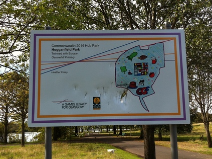
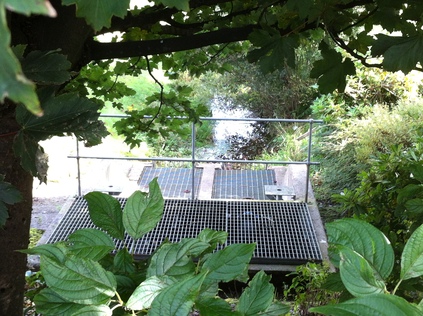
My next aim was to find the point that the Burn entered Hogganfield Loch. This too proved incredibly difficult to achieve. I edged my way along the main road, noting that in fact despite the peeling stucco on some of the little cottages, this wasn't a bad place to live. The road pushed busily on to the City around five miles away, and there was something of a rural feel to the place. I trudged alongside a green municipal railing that enclosed a well-kept park. In there somewhere, the above-ground expression of the Molendinar lazily ran between the Lochs. There was a large sports centre, and the railings were locked wherever there was a gate. I eventually found Avenue End Road. This strangely empty, semi-derelict rat-run delves south to link with the M8 and Edinburgh Road, and as such was well used. It also became clear there was no way into the park. It was Strathclyde Region land, marked as playing fields and privatised. I could see where the woodland would have brought me in far to the south, and tantalisingly under the rise of the road, I could see the gratings which led the Molendinar into it's first culvert. Crossing the street and an alarmingly boggy triangle of land, I entered Hogganfield Park. The North East of Glasgow is a closed book to me, and merits exploration in the same way that this quarter of London which has occupied my thoughts. Here there was another echo - a sign declaring the park a "2014 Games Legacy". I shuddered, suddenly aware of how this would change the city.
I pressed on around the fine and extensive park which circles Hogganfield Loch. It was quiet except for joggers and dogwalkers, and I sat and watched for a while. At the far, western end the municipal golf club offered facilities - but not for the likes of me. Children ate ice-cream and fed ducks or swans with Waitrose bread. This was a strange collision of a working class playground for the North East and the edge of suburbia. I contemplated a return to the city on foot, braving motorway bridges and edgelands, but now my time- and range-anxiety kicked in. Maybe if I'd not needed to be back for a train - which was in reality hours away - I'd have done it. Instead I boarded a bus which clung tight to the Burn's hidden route - at least as far as the head of Wishart Street on the edge of the city. This was to be my first arrival at Buchanan Bus Station too, that busy confusing mass of humanity and machinery which decants vast portions of the city, especially from the areas I'd been walking today.
I spent the rest of my day reading, writing, drinking coffee and just enjoying being in the city. I can't help feeling my jaunt to the North Eastern edges is incomplete and unresolved. Perhaps when I'm back in October I'll revisit this odd quadrant of the city. For now though I have grainy, indistinct pictures of the Burn before it disappears from view. Mission sort of accomplished?
The Circle Completed - The Lower Lea Valley
Posted in London on Saturday 15th September 2012 at 11:09pm
The difference today was that I had at least planned to be here. My year planner is peppered with these trips to London in the safe knowledge that they will find me exploring some new geographical obsession or other, and that I'll have a reasonably relaxing journey on the rails. Sometimes, they become little excursions beyond the city - but even then there is always the luxury of an early arrival and perhaps a bus ride. With the world of railtouring changing considerably there have been more trips than I ever quite planned, but this has lead to walks across the eastern side of the city I'd probably not have countenanced before too. In this sense at least, the fractured and haunted summer has been a success in retrospect and I look back fondly on those walks which sometimes didn't seem significant on the day, but which have clicked into place later. I could only hope today would do the same for me. Because, today I had half a plan.
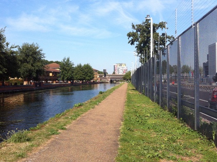
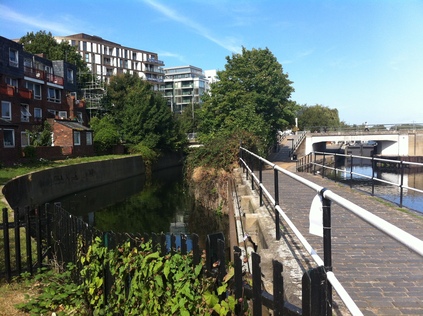
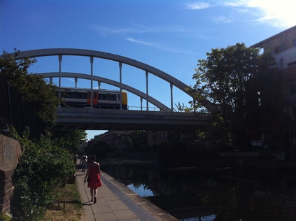
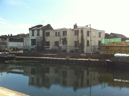
Today was, essentially, a completion. I'd read online that the towpath along the Hackney Cut was open - if still patrolled by G4S around the Olympic Park perimeter. But it was open nonetheless, so after a lazy breakfast in welcome late summer sunshine I set off east on my usual bus route. It was quiet, a cool but shining morning as we headed around the arc of the bus route. I saw it through almost to its end, hopping off near Bow Garage for the walk to the Church. I stocked up on water too, it looked like later when the sun was high it was going to be hot. I dodged traffic at Bow Interchange and found the footbridge down to the towpath just how I'd seen it on that excursion months back. I pondered what that had started: campaigns, obsessions, imaginary love affairs, endless wanders. I descended slowly, savouring this progression onto what had become hallowed ground. A battle fought over a strip of scraggy land beside a turgid canal, walkers and cyclists uneasily united. It was good to be back. Quickly, The Fence is alongside. Beyond it? Nothing. No movement. The occasional distant crash or scrape as unseen contractors strip back "the overlay" from the park. Empty staff buses circuit, the contract outliving their usefulness. Occasional security cars emerge. Overhead, a helicopter constantly drones. Crossing and recrossing the park. Even now it's a focus for paranoia and concern. I walk on, past the Northern Outfall Sewer carrying the still off-limits Greenway, past Hertford Union Junction, White Post Lane. I'm on the stretch which was guarded when a small orange boat called "Vigilance" passes by. They're not interested anymore. I stop, take a picture, watch the sun bounce of the gilt lettering of Formans, speculators on the Olympic dream. I could oppose Lance Forman's take on the Games, but he's still here in the Wick, his modern but organic new headquarters swooping gracefully and cheekily nodding at the Orbit across the water. Finally I reach the closure point - further than I ever managed on this side. The little brick circle still allows cyclists to pause and read maps. The boat ties off here, the lime green shirted guards head into the park. I make a decision - I'll press on out of its gravity - I'll get free of this place at last...

The last stretch is hard going - but is oddly rewarding. Busy boat houses provide a home for the canoes and rowing vessels which have passed me all morning, receiving commands from bicycling captains with loud-hailers. There has been a post-Olympic surge here, the junior section in particular is busy. Whatever the skepticism I might hold about the Games and this swathe of London, it's genuinely heartening to see this. On the east bank Springfield Marina is full of a different kind of vessel - a life on narrowboats always seemed a corny cop-out, but now I see it's attractions more clearly. Is this another mid-life crisis looming? I pause to finally empty my aching bladder at Markfield Park Cafe, in the shadow of the great Beam Engine. This one dealt in the pumping of sewage - part of the scheme which cleansed London of its filth, now regenerated into a rather fine little corner of the parkland with a museum, a cafe and places to relax and play. It felt positive and well-used. I considered lunch here, but again thought that stopping might be final. I returned to the path for the last push. Under the railway again, the curve to South Tottenham breaking off just feet from the river and the Cambridge line passing directly overhead. The river turns north and the Gospel Oak to Barking line crosses on a low bridge. Some young black guys explode from a side gate swaggering and yelling. I glance at one and with little interest he utters "Yeah. Come on then? What you gonna do then?". It's momentarily startling, but empty. He rails against everyone I guess, but fat white middle-class guys tramping river banks must be appalling to him. I press on, waiting for another walker to pass me before checking they headed in the opposite direction. Its the one time I've been even mildly concerned for my safety on the riverbank I realise. Finally, Tottenham Lock hoves into view - but just before it does, the path rises over a side-stream. Curving away in a concrete culvert is Pymmes Brook. It's an inauspicious little rivulet. Dirty and slow-moving in it's stony gully. But this leads onwards towards Tottenham where the tiny trickle of the Moselle River joins it. I have linked up with an earlier walk and it's strangely triumphant to think how there is coherence to my ramblings. I ascend to civilisation with some regret...there is more river to walk ahead, but not today.
I realise I'm hungry and thirsty, and raid the newly opened Tesco near the station. Its a strange corner of public-private land here with fine new flats, a gym and a supermarket all protected by an ugly 1980s security kiosk - unmanned of course. No alcohol allowed. I munch pastries and glug fruit juice, wondering if this is allowed. Finally, dusted off and replete, I head for a train back to Liverpool Street and welcome coffee. I also realise that I booked a much later train than usual home - so there's no hurry, and I decide to use the buses to cross and recross the territory I've walked. To get a different slant on the land I've carved through by river. Thus I find myself crossing Lea Bridge and looking down on the spot I regarded it from earlier before arriving at Walthamstow Bus Station. A drunk has stumbled into a slow moving bus, an ambulance in attendance. Ill-governed crowds crush and flock to buses. I make the back seat of a 69 to Canning Town, wedged up against a tiny but pretty Polish mother. This bus takes me via Leyton, the eastern edge of the Olympic Park pushed up against the homes and shops of the borough. It's another circle complete - and another set of possibilities and gateways opened. What started with uncertain rail journeys before the bid, turned into a curious regard for this strange strip of land, and now manifests itself as an urge to walk, has come full-circle. This is now a voyage into post-Olympic London. Legacy delivered or reneged on? I find myself already wanting to be back here.
You can see more pictures from the walk here. As an experiment, you can also follow the route on the map below - the blue line is the walking route.
View Lower Lea Valley Reconnected in a larger map
Once again I found myself in London today, again without a firm plan, though not quite as unexpectedly as last week's jaunt. This habit of dashing to the capital runs counter to my original plan - that I'd not even try to visit the city during the Olympics or Paralympics. Having allowed myself a brief wander between the two, I was pretty surprised by just how little effect the games had on me last week, despite an unplanned lurch towards the park before heading off on my canal walk. And it was that walk which provided the kernel of the idea for today. Many years ago, for some lost reason, I found myself walking the towpath of the Regents Canal between Regent's Park and Camden Town. I don't remember quite why or how - but the odd serenity of the walk, and the strange noises emanating from London Zoo's aviary stick in my mind. Then again, years later I found myself stumbling around Colebrooke Row chasing the ghosts of the Lambs and wanting to get to City Road basin, just because it was a curious feature on the map which intruded into my then current territorial obsessions.
Skipping forward to today, I alighted from a bus at Angel Station. The sun was already high in the sky and beating torturously upon London. I got water and sustenance and headed for Colebrooke Row once again, taking the steep curving path which skirts the mouth of Islington Tunnel. On my way down I noted a gent idly pissing against the tunnel end wall while a couple of Japanese tourists sat nearby. It was going to be an odd walk. The plan was to link my travels - to go beyond City Road and to reach Victoria Park where I'd left the canal previously. From there? Who knows... These canal walks have become a little more than just explorations - they have become ways to re-evaluate territory I already know, and quick and easy ways of edging through the choked city above too. I set off eastwards, through the relatively affluent edge of Islington.
My first observation was how busy the towpath was here in leafy and largely well-off Islington - the canals of the east are deserted on the whole because of the inconvenient and illogical Olympic blockades and the message propagated by LOCOG and TfL that implies everywhere will be impossibly busy. Here though there was a constant traffic of joggers, families and cyclists. Notably they were less considerate than their eastern counterparts too - no bicycle bells rung in warning here, but should you not detect their presence they'd be rung in anger. Some of the overbridges create very tight walking spaces, but the cyclists push on through with little regard for pedestrians. Its a short walk to City Road and Wenlock Basins, where new territory starts in earnest. The banks here are edged with visiting boats which add colour and life to these sometimes eerily quiet zones too. The confused summer of damp weeks and days of intense heat has encouraged algae and there is a green carpet on the sluggish waters as I press on beyond Sturt's Lock and the canal begins a curve towards the south east. It's reckoned by official guides that this section of the route is the least pretty and interesting, but in truth aside from some notable developments which squeaked in before the downturn, its probably the least gentrified section of the canal. This makes for some splendid industrial vistas - tumbledown works, sometimes with their ground floors re-occupied by restaurants or art spaces. As the route turns around the north eastern edge of the city into De Beauvoir Town I'm struck by how many major routes cross it - the New North Road, the East London Line, the A10. The canal was the precursor of any future Ring Road.

I rest awhile near Kingsland Basin, primarily a building site for a new development which against the odds is still underway. Families pass by shading babies against the intense heat. Joggers are reduced to walking pace, heads hung low, sweat drenched backs. They're an attractive bunch out here - and some of them have applied make up for their midday jogs. Perhaps this is how you meet people in the modern city? Pressing on into the backlands of Kingsland Road. The buildings crumble visibly, the canal is littered with junk. There are pop-up businesses here - vintage clothes, coffee, cakes - sold from boats which double as home. An alternative waters edge economy. Threading through South Hackney, the towpath again begins to get congested. The sweep around Andrews Road and the huge gasholders I'd snapped on an earlier walk is a particularly busy stretch - a film-crew idles in an abandoned and decrepit canalside house while Mare Street rages overhead. This is the last stretch now, as the canal draws alongside Victoria Park. It's leafier, cooler and the park draws away the bulk of the walkers here. The last stretch is home to some longer-term residents of the waterway. They sit at the back of their boats, discussing and reiterating, occasionally looking up to see who is passing. Finally, a little before Old Ford I turn into the park myself. I've found my way back to the spot which I reached on my Hertford Union trek a few weeks back. I reward myself with a rest. In the blazing sun of the park, London is doing the same. After negotiating an unwarranted and pointless police check I find a bench, make some calls, receive surprising a somewhat gloomy news. Instinctively, and perhaps ill-advisedly I strike out east across the park. Passing the unnerving Dogs of Alcibiades and cutting through the Night Walk to reach the quiet curve of houses, skirting Mabley Green and not really having any sense of where I mean to go next. A couple of students mess with expensive camera equipment in the long grass fringing the park - everywhere I go people are filming, trying to preserve this strange atmosphere. I come to my senses at the Eastway junction. I can see the route ahead which almost floored me a couple of weeks back. Any further, and I'd be straying too close to the source of my concerns. The last days of the Games are no place for me. I turn disconsolately back and head for the bus stop.
Whilst I hadn't meant to be here today, I was able to use the opportunity and the remarkable weather to cover ground I knew I would need to at some point. These last, heady days of the Olympic Summer have suddenly become significant, the country doesn't want to get back to normal - and the city has been lulled into a strangely calm sense of separateness. Tomorrow there will be speeches, fireworks, music - no doubt tears. On Monday, all being well some hi-vis wearing contractors will remove the barriers from the towpath on the Hackney Cut. That, after years of crossing and re-crossing the site, after failing to understand the nature of the site, was what brought me here. The summer of walking inland waterways - partly by design and partly by necessity is almost over too. There will be no ceremony - just new endeavours to understand the post-Olympic city.
You can see more pictures from the walk here. As an experiment, you can also follow the route on the map below - the blue line is the walking route.
View Regents Canal Revisted Walk in a larger map
Lost::MikeGTN
I've had a home on the web for more years than I care to remember, and a few kind souls persuade me it's worth persisting with keeping it updated. This current incarnation of the site is centred around the blog posts which began back in 1999 as 'the daylog' and continued through my travels and tribulations during the following years.
I don't get out and about nearly as much these days, but I do try to record significant events and trips for posterity. You may also have arrived here by following the trail to my former music blog Songs Heard On Fast Trains. That content is preserved here too.
