When I've mentioned that I'm curious to walk the A13, people have looked a little quizzically and asked, simply, why? I suppose they're used to my manifold topographical obsessions, complicated literary mash-ups and generally curious nature. Of course, roads were a very early interest - as a boy I'd scrawl imagined maps, but rather than pirate treasure they featured complicated interchanges, improvement schemes and Ministry of Transport approved signage. My interest in networks has never gone away - my railway obsession, the desire to map and understand London. However as a surprisingly - and perhaps given this interest, illogically - unlicensed driver, roads are a vicarious and distant pleasure. I recently began re-reading Iain Sinclair's "Dining On Stones" - a semi-mythologised walk out of the city via this route. Ten years later, with more exploration of my own under my belt the text made a great deal more sense. But it also posed questions about how the post-millennial fringes of London were changing, and how Essex and the city interacted. Sinclair's text is amusingly self-parodic, pitched somewhere between nostalgia and dystopia. That has actually always seemed a good measure for the little of the road I'd walked - and is perhaps a pretty good starting point for the whole of the British road network. A creation of the 1920s, these numbered and classified routes have drifted in and out of logic over the years as they have been re-routed, bypassed and decommissioned. Walking a road from origin to end-point seems a little out-of-character maybe? After all, much of it will be open country and far from the edgeland fringes and grimy city channels I seem to prosper in walking. But it feels like a project worth undertaking - simply because it's there to be walked. And so, on a blustery but strangely warm December morning, my trudge began...
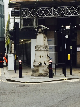
Setting out from Liverpool Street, I head through the fringe of the city and along the almost-deleted street of Houndsditch. The development encroaching on this ancient byway threatens to overwhelm it completely, hemming it in with tall towers. I make for the spire of St. Botolph Without Aldgate, once beleaguered by traffic but now subject to a public realm scheme which will create a pedestrian friendly approach. I pick my way around the works, noting how the wind has risen now I'm clear of the channel of office blocks - it's not a cold day, in fact it is perhaps oddly mild for early December, but the wind chills me. I grasp my cup tighter and navigate a little to the west to find Aldgate pump marooned between the arms of a junction and crumbling slightly. Some nonplussed and rather troubled looking Asian tourists regard the pump and the general area before snapping quickly, uncertain of what this monument represents, and retreating west. I take the opportunity for a picture - the official start of the A13 and therefore the embarkation point for this walk. It is an inauspicious, dirty and noisy start - the road east is a confusion of development sites, cranes set against a slate sky. Like always at the start of these wanders I doubt my purpose, doubt even my wisdom in being out here. But it's time to set off. I gently - and perhaps rather pointlessly - nestle my cup in the base of a now decommissioned litter bin and turn east. The A13 is a disputed route as many of the original roads designated in 1922 now are. There are some solid facts - it originates in the city and heads east, taking in Barking, Dagenham and the southern reaches of industrial, esturine Essex, before depositing daytrippers in Southend-on-sea. Officially it then presses on a little further to the shadowy Ministry of Defence bolthole at Shoeburyness, just a step away from the officially designated 'Danger Zone' of Foulness Island. Beyond London, the route is up for grabs. Once out of the confining grip of the city street pattern, it heads along a several-hundred year old alignment which served the docks, before turning a little north to provide the main drag of Canning Town. Here the first bypass starts - a swathe of much improved road takes the route a little south, ploughing through the previously empty industrial wastes towards a new crossing of the Roding. When I explain to locals that I'm walking the A13, they perhaps understandably ask "Which A13?"
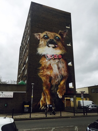
For now though the route is clear, and with Aldgate behind me I turn a little south and then east onto Commercial Road. This stretch of route is grim - an unrelenting parade of closed and shuttered shops on a Saturday morning. Some it seemed were aiming to make a feature of their distress - a little bit of imported Spitalfields glamour perhaps? Otherwise though, it was a mix of fried chicken emporia, sub-continental clothing retailers and student housing. The broad, empty road leads away from the city towards Limehouse, taking in some of the most contested territory in London. The most deprived wards of Tower Hamlets - indeed of the UK - crashing on the affluent beaches of Docklands. Mostly, it seems to work - the repurposed viaducts carrying the DLR serving as a firebreak across the Isle of Dogs, severing gloomy Blackwall and Poplar from the shining towers of light. As I discovered on an earlier walk, it's not easy to move between the mainland and the Isle - perhaps designedly so. First though, the tower of St. Anne's Church looms over the railway bridge, the road turning a little to circuit the northern fringe of the churchyard with its curious monuments. Beyond the church a tall tenement of dirty brick buildings claims to be a "VIP Garage". It very likely isn't. Crossing the canal, the road becomes East India Dock Road - a georgian thoroughfare which retains some of the fine townhouses which once lined both of its sides. Traffic is officially encouraged to leave the A13 here, taking Aspen Way and skirting the fringe of Canary Wharf on a road which seems to be neither public nor entirely private either. Sticking with the old route, the chill wind has finally challenged my coffee-filled bladder and I'm forced to leave the route, ducking into Chrisp Street Market. I've passed by many times but haven't really strayed far into the historic precinct. Historic because this humble concrete chasm leading to a purpose-built market square was the first such pedestrianised shopping area in the UK. Since its creation for the 1951 Festival of Britain, this pattern has been repeated endlessly and thoughtlessly over the British Isles, sometimes to terrible effect. Here though it worked - and it remains prosperous, inviting and has the sense of being a resolutely local spot which bears evidence of investment and renewal - including a fine new library building. There is a literal whiff of gentle gentrification - the range of ethnic food outlets in the Market participate in a regular Street Food fair for instance. The confusion of drifting smells from Chinese food, pie and mash and Indian cuisine purveyors signifies this might well be a good thing. I'm tempted to linger - but there is walking to be done. Leaving the market by the side entrance I'm confronted by the mass of Balfron Tower looming over the Brownfield Estate. Turning my back on it, I see it is defiantly opposed by a house-sized mural of a puppy - the kind of over-sentimentalised, big-eyed creation you'd see on a cheap birthday card. I leave the tower and the market's unlikely guardian to their own devices.
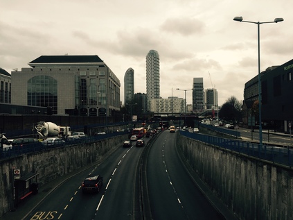
Back on the A13, the northern fringe of the road is also the perimeter of the Lansbury Estate, with generous green spaces and local facilities evidently still functioning. This is the kind of philanthropic planning which the nation cries out for often, but rarely gets - and certainly not here. Now, along with Chrisp Street, managed by the slightly shadowy Poplar HARCA it soon peters out into a mess of projects on former public land: half-built towers and empty spaces with hoardings proclaiming future opportunities. Between these, businesses still sell fast food, SIM cards and tyres or front mysterious travel money operations. Suddenly, and noisily, the scene opens up as the Blackwall Tunnel Approach Road dives under the A13, the tunnel portals visible to the South. Looking north there is a strangely compelling view of Balfron Tower and distant Stratford with the ludicrous Orbit standing out from the former marshes. I take a wrong turn, coming to a dead end in a swirl of dry leaves and litter. Retracing my steps, I halt in the middle of the mess of footbridges crossing the tunnel approach to capture views north and south. The road is breathtaking in it's sweep and severity, and my onward route here is decidedly the minor player. The once proud road to the docks usurped by the north-to-south torrent of commuters and shoppers. The road is swiftly closed in again, hemmed between more new hazily public-private development and the grey prison fascia of the Docklands Travelodge. Tucked between here and the river, straddling the former East India Dock, is the Mulberry Place headquarters of Tower Hamlets Borough Council - expensively leased since 1993, with an equally profligate move to the former Royal London Hospital planned. The area is carefully managed to be as banal and inconsequential as possible, reflecting the strange belief that a deserted place is more secure than a busy, civic centre. I take a turn away from the main road here, following the dock wall which divides the carriageways of Leamouth Road. I know there is a strangely isolated service station at Orchard Wharf which provides an opportunity for sustenance beside Bow Creek. As I turn south a squall of wind stops me in my tracks. A mix of building dust and silt covers me, my sweater sparkling with silica and a salt grind between my teeth. I adopt a crabwise shuffle to edge around the open entrance of another new development of rental towers from which the dust seems to originate, and cross the street to find the garage. But it is gone. The windows boarded, the forecourt a screed of stones. The building looks oddly forlorn, swept by river winds and blasted by sand it is already peeling and crumbling. Still surprised, I retrace my steps towards the road. Change here is swift and absolute it seems.
Re-crossing at the confusion of lights at Leamouth Interchange, I'm struck by an odd sight: the new Lighterman's Point development towering above is fringed by a street of fine old terraced houses, diving off at an oblique angle and defiantly refusing to be part of the new zone. Aberfeldy Village isn't new - this colony beside the creek has co-existed, indeed been co-dependent on the dirty, industrial fringe of the River Lea for generations. Its new guise sounds more like a drug-trial than a locale - but we're reassured that 'AV-E14' is importantly not regeneration. That's a filthy and devalued term here in the Lower Lea Valley. This is reshaping, re-imagining even. I'm confused and confounded by this however: London has a terrifying housing problem. It needs a mix of accommodation and it needs it fast. These old, solid family homes are being replaced by blocks of student housing, one bed luxury apartments which house couples at best, ground-floor retail units for a zone with no centre. The line of proud, tidy houses are surely an essential part of the mix? Absent-mindedly picking this over, I climb the curve of the bridge which takes the A13 over the intestinal curl of the Lea. I can be in no doubt what road I'm on - all three lanes are proclaimed A13 by the overhead gantry. The views south are occluded by the road, but looking north I see the forbidden edges of the river where no path is available. The curves and bridges are familiar, well worn, often revisited. Landmarks stud the scene - remembered tower blocks at West Ham, the cluster of silvery columns of Stratford City, the ever present and never welcome Orbit. Descending from the bridge is leaving 'London' in some ways, heading out to the marshes. The road divides, the old route becoming Barking Road and dividing Canning Town with a mix of over-familiar high street names and local colour, while the new road is a non-pedestrian flyover snaking above the streets. I shop for food before rejoining the route as the bridge touches down. The pattern from here on is set: a broad cycleway and pavement set alongside the northern edge of the six-lane road. I pause to eat at a local exit for Prince Regent, sitting on the concrete podium of a telephone switch box. The old streets intersect the new at strange angles, the rooftops of Victorian terraces coming to a sudden, premature halt where the new road gouges through long-established districts. I set off again, and realise I'm getting strange looks and creating interest in passing drivers. It's perhaps not surprising - I'm a wild-haired, heavily bearded walker in a sweater and rucksack despite the December cold, and by far the only pedestrian for miles. Even the occasional cyclists look askance. Then it becomes clearer - the high fence and cameras fringing the bank beside me belong to the Newham Centre for Mental Health. I'm an assumed escapee. As I suck fumes and regard the featureless view ahead, I wonder if they're not right?
It is entirely a myth that traffic thunders. Out here at least, the sound of the stream of passing vehicles is a endless and metallic, ululating drone. On another day, in the peak hour, it might almost be silent - a string of unmoving red tail lights stretching back to the city. But on a December Saturday the cars flow steadily, punctuated by occasional business vans - their drivers pressing 'phones to their ears and chewing on thick hunks of sandwich as they shuffle lanes testily to gain a little on the cars doing strictly the correct speed. Here, as the gravity of the city weakens, the road speeds up. Hamstrung until now by a low speed limit which makes a mockery of its quality engineering, the A13 makes a curve north, skirting Beckton's retail parks and low-rise housing schemes. Of course the original route swevered too - dodging the swathe of industry between here and the River Roding and the vast gas and sewage metropolis which filled the alluvial flats between here and the docks. In the middle distance as I round the curve, the road bucks and weaves to the left. Beside the ramps of the next grade-separation is a tump of green, wooded but with a bald and exposed top. Beckton Alp, seen from this direction at least, is impressively elevated in an otherwise level plain. The iron palings which edge the summit freshly blackened and adorned with new graffiti: All power to all people. Denuded of foliage by the season, I see a white-coated dog walker make the summit and stand for awhile, companion capering around - a distant flickering stick-animal. I cross the A13 by the footbridge, towering high over the six lanes of chaos and challenge below: cars fence for position, forcefully occupying the space just left by others as they weave, looking for some tiny perceived advantage or realising too late they need the exit. I resolve to get all the way to the top this time.
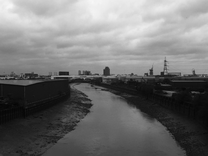
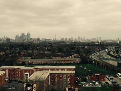
The entrance to the Alp is much as I found it last time - an anonymous metal gate with a businesslike padlock attached to a drawn back hasp. My fear that this would be deployed during my visit was unfounded, and this time I'm less concerned. I enter the gateway and start to ascend, zig-zagging back and forth and dodging the inventory of what appears to be a small colony of nocturnal inhabitants: Polish lager cans, discarded jeans, extinguished fire-pits, condoms. The path is cracked and fissured by tenacious bramble stalks reaching for sunlight. It's easier going in Winter though, with the overhanging foliage and colonies of midges absent. I see the dog walker below, leaving by the other gate and decide it's time to make my own assault on the summit. As I reach the end of the official pathway I see a gap in the fence where the bars have been bent apart like a cartoon jailbreak. I size up the gap - it's pretty big, but then so am I. I pass a leg through, stoop and swerve to get my rucksack under the bar, then I drag a second leg through and I'm on the other side. The reason this area is gated off is immediately apparent: to my right is a decaying wooden platform dating back to the ski-slope endeavour. It is clearly a pretty risky structure, and only a complicated insurance claim could follow any attempted use of it. Looking left up the slope however there is a well-worn track which curves slightly towards the summit. A quick scramble, assailed by the wind gusting in from the estuary, and I'm at the top. Suddenly all of London is before me. It was impressive from below, but here, unhindered by the trees it is magnificent. Ever present, east and west, is the snaking A13 - a ribbon of dim lights in the increasingly gloomy afternoon. Looking south, the sugar factory at Silvertown towers about the low rooftops of North Woolwich, and beyond is the glowering rise of the Kent coast. Looking east, following the road, is a maze of warehouses and retail hangars between here and Barking - all clad in the same corrugated shells, as white as the goods they are peddling. The flood barrier casts a shadow over the brown snake of the River Roding, and beyond? Well that's where I'm heading...
Descending from the Alp I catch a bag strap on the fence leaving it mildly distressed, but perhaps surprisingly I note it doesn't worry me. I'm aware I've been in a near constant state of activation for months - anticipatory, dry-lipped anxiety has become the everyday state. The mess of finances and legalities has begun to seek a proxy in other, worldly concerns and a bit of mild rucksack damage would normally feel insurmountably challenging. Like an overtightened cello string, I've involuntarily vibrated to the noises around me. Oddly though - and I can't stress how rational I usually am, or how ludicrous this sounds - I feel like I've left something up there in the wind, swirling off into Essex. I start homeward by picking through a retail zone unusually carelessly. I'd normally be concious of my oddness, my separateness from the line of consumers' cars. Attracting attention by trying too assiduously to avoid it. Soon, I'm treading an old railway path cutting diagonally towards the docks. The wind swirls litter and autumn leaves across my path. I'm starting the long journey home feeling oddly calm.
You can find a gallery of images from the walk here.
Lost::MikeGTN
I've had a home on the web for more years than I care to remember, and a few kind souls persuade me it's worth persisting with keeping it updated. This current incarnation of the site is centred around the blog posts which began back in 1999 as 'the daylog' and continued through my travels and tribulations during the following years.
I don't get out and about nearly as much these days, but I do try to record significant events and trips for posterity. You may also have arrived here by following the trail to my former music blog Songs Heard On Fast Trains. That content is preserved here too.
