Out of the Voracious Sump: Walking back from Essex
Posted in London on Saturday 3rd February 2018 at 11:02pm
A steady rain was falling on the shining pavements of Upminster. Not heavy enough to make me pause in my plans for the day, but equally showing no sign of relenting any time soon. The trip out here from the city had been convoluted, but had passed surprisingly quickly and without any major disruption, and I was setting out a little sooner than I'd expected into the damp town centre. I'd never been to Upminster before. I'd certainly passed through: on trains scudding out to the coast, or on long meandering walks along the nearby Ingrebourne River - but I had little preconception of what I'd find at the top of the station steps. Somewhat unexpectedly, Upminster had the air of a prosperous small town. A smattering of the right kind of stores peppered the parades of interwar red-brick suburban shop-fronts flanking the street, breaking up the usual aromatic mix of takeaways and hair salons which are never far from a station. I was heading for the crossroads at the centre of Upminster where the A124 begins its journey into London from this almost-Essex town turned dormitory suburb. The ancient centre of a village with a long, distinguished history of being on the edge of a relentlessly growing London, Upminster was dragged - administratively at least - into its gravity in 1965. But the place still feels, and to some extent looks, like a market town in rural southern Essex. Squeezed by the statutory girdle of the Metropolitan Green Belt to the north and south, it edges out towards the M25 and even breaks the membrane to stray a little beyond. The District Line quits at Upminster having reached here in 1902, while the parallel tracks of the London, Tilbury & Southend Railway are left to continue the journey east. In fact, the District Line tracks struggle on for a further mile or so beyond the station into the vast depot at Cranham, near where the majority of the TfL-commissioned red buses also give up and turn back west. Upminster grew dramatically after the coming of the railways, blossoming again between the wars to become the de-facto district centre for the sprawl of new residential suburbs here at the edge of Greater London. As such it has perhaps never been well to do in the strictest sense, but today at least it certainly felt like it was doing well enough among the liminal uncertainties of 2018. I passed numerous well-dressed young folk heading for the station, drawn in by the train into 'town', though there were perhaps surprisingly few non-white faces peering down at the screens of 'phones and tablets. This is another boundary - a distinct zone where London's legendary diversity peters out entirely. Upminster didn't appear to suffer the bitterly proud, BREXIT-stoked racism of Dagenham or the knife-edge tolerance of Barking's complex population mix. Here it was just olde-England's shire-county conservatism accidentally straying into the edges of the city. I surveyed the corner up ahead with some trepidation. To the east was Essex - and Waitrose of course - but to the west was the massive, brooding imposition of London. A huge gravitational drag along the busy A124, an old road which has wound in from Essex for hundreds of years. Today I was using it as the pretext for a walk in from the edges. A return to the east which felt long overdue. If I started walking, I knew I'd feel the sense of another project underway. I recalled Jonathan Meades closing remarks in The Joy of Essex about the county's ability to consume and reclaim, not least referring to the absorption of whatever London cast out, and wondered quite where this walk would take me?
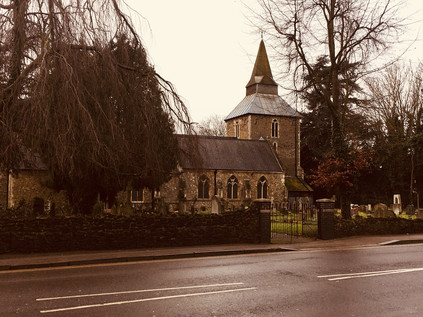
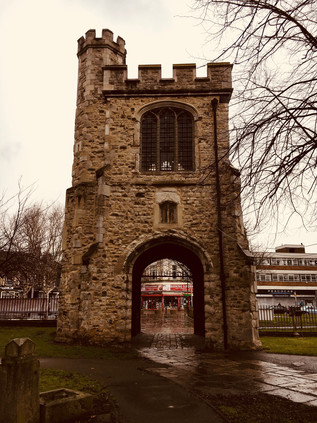
To the south of the crossroads, the squat tower of St. Laurence's Church loomed over the highway looking every inch the rural parish church despite the presence of a busy branch of Lidl nearby. From the tower of St. Laurence in 1709 the Reverend William Derham made remarkably accurate measurements of the speed of sound by way of a telescope and the flash of a distant gunshot, timing the report with a half-second metronome. These scientific pursuits seem a strange kind of work for a country parson, but it seems he was perhaps no ordinary cleric. Derham's written work fuses his theological and philosophical arguments with a surprisingly open and naturalistic mind, describing nebulae, natural variation in species and distant star clusters in his effort to forge a tangible Physico-theology. Resting near Derham in the churchyard, and like him with no memorial is Alice Perrers, mistress of King Edward III - a popular monarch in his time who seemed to fall out of favour with modern historians for not foreseeing the part his legacies would play in dividing York and Lancaster after his passing. The fact that he took no mistress until his consort, Philippa of Hainault, was terminally ill displays rare royal restraint for the period. The quiet of Derham and Perrers' repose was challenged by the steady westward stream of traffic which fussed and boiled to navigate around the regular procession of buses starting their journey back towards Romford. As I passed by, an older lady tripped and fell at the bus stop outside the church with the sickeningly specific sound of a crumpling body hitting concrete. A car screeched to a halt and someone was soon helping her back to the seat. She patted the helper away, protesting that she was fine and had just slipped. It was hard to tell if the dusty but otherwise seemingly unharmed woman or her good samaritan was more embarrassed by this un-British display of kindness - but it made clear that I was not in London. Somewhere between here and the city the tone changed and any unusual happening or public mishap was a non-interactive spectacle, a situation worthy of recording but not of intervention. Uncomfortably, I realised I'd just done the same - and so I moved on.
While the sprawl of suburbia along the A124 meant that little of the substantial swathe of greenbelt surrounding Upminster reached the margins of the road, there were still distinct divisions between the former towns and hamlets which straggled along the road. As I left Upminster, passing the windmill which has remarkably survived since 1803 but is currently shrouded in white for repairs, I began to descend into the valley of the Ingrebourne. I had briefly passed this way before, emerging from the farmland to the north to pass under the railway and head south towards the Thames. This time I was crossing the territory from east to west, and thus I was far more aware of the deep groove carved over the millennia by this apparently modest little river. The bridge here was first recorded in 1375, and the current brick bridge is at least the fourth on the site, dating from 1892 and once complete with cast iron sidings from the Whitechapel Bell Foundry. At times a ford supplemented the bridge, such was the importance of the route. But now the crossing was easily missed, with most assuming that the nearby Upminster Bridge station on its high brick viaduct was the origin of the area's name. Remembering the short strip of shops here I popped in to stock up for my walk, and emerged to find the rain slowing somewhat. Encouraged, I struck off westwards again, crossing Hacton Lane - which formerly led to the now almost entirely absent hamlet of the same name. At the crest of the hill the tall verdigris-covered spire of St. Andrew Hornchurch announced my crossing into a new parish. At the eastern end of the building, a stone bull's head pointed its horns back east - an 18th century addition, with the name of the area long-predating this somewhat literal interpretation. Despite the presence of the usual range of High Street ubiquity, there was a sense of something ancient about Hornchurch. The mock Tudor villas which had stretched along the road behind their well-kept but traffic-battered gardens petered out a little outside of town. Their faux-historical take on the old vernacular was overshadowed somewhat by the presence of the genuinely venerable, haphazard tumble of the Kings Head - now occupied by Prezzo who have shown remarkable restraint in preserving the building's dignity. But Hornchurch offers a rather more distant link to pre-history, being the most southerly point in Britain which sheet ice reached during the last ice age some 450000 years ago. The ancient geology is reportedly best seen in the railway cutting which carries the rather quiet Overground shuttle service from Upminster to Romford, where layers of geological detritus carried from the Midlands by the advancing ice can be found above the native Essex clay. The town centre of Hornchurch bustled and rushed, apparently unaware of its historical importance, centred on a knot of roads linking the suburbs to the north and south. I paused for coffee here, watching the comings and goings of the locals. Perhaps more than Upminster, this felt like a place distinct from the surrounding city and suburbs - a busy town which could perhaps be anywhere in England. That said, it was clear that the area owed much of its prosperity to the gravitational pull of London, with a steady stream of pedestrians headed briskly south towards the station as I looked out over town. If Hornchurch had been plucked up and deposited in the Midlands by some trick of the retreating ice, it would no doubt have struggled to survive.
Underway again, the road took me briefly into green space at last, dipping to cross the tiny Ravensbourne near Abbs Cross Lane. This brook hadn't featured in my previous walks - largely because much of it runs through the back gardens of suburban homes and other inaccessible places, meaning little of its relatively short length is walkable until it reaches the lake in Harrow Lodge Park near its confluence with The Beam. The road here was busy with speeding traffic navigating the curve and rising away from me in a cloud of spray and fumes. I paused in the steady drizzle to snap a picture of the tiny watercourse hemmed into a weed-choked concrete channel under the road, and incurred the interest and apparent displeasure of a passing local laden with Sainsbury's bags. He passed me, tutting and muttering although I posed no obstacle to him, then frequently looked back, suspicious of my motives in photographing the stream. As I made the steady climb away from the Ravensbourne, the rain began to fall more steadily. I was already soaked through and decided not to let it bother me. The road plunged into dreary and damp suburbia again - a long stretch of housing filling the spaces between the old towns of Essex which had once been prime farmland. I trudged on, wondering if this walk was just too contrived and obscure to really have a focus? How could I connect these disconnected blips of population which huddled along the District Line for safety? It was easy to feel discouraged in the gloom and damp, the only diversion arising from the need to move deftly to avoid being splashed by passing vehicles. Few people were around, and faces gazed at me from warm, comfortable cars in disbelief. Why would he walk out here? No-one walked out here.
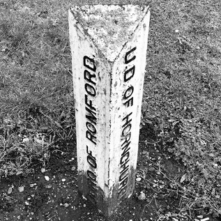
And so I found myself back in Romford. My route skirted the southern edge of the town, passing the site of the former Roneo works, now a vast retail development which nestled into the corner where the main roads met the Beam River where it emerges from its largely unremarked passage under the Town Centre. The area around the former works site is a confusion of closed cafés and repurposed shops now doubling as offices and builders' merchants. It's clear that the departure of the factory, a huge employer locally, had left this outlying corner of Romford beleaguered and purposelses. The river plunged underground again to negotiate the busy junction with the A125, though its disappointing trickle could be seen in a deep concrete trough curving north alongside the road through the grounds of the vast new Queen's Hospital. South of the junction, the stocky and purposeful tower of YMCA's Thames Gateway building loomed over the otherwise flat landscape of the Beam Valley. My last passage through this area, when walking along the river, had been on a brighter spring day when a swift crossing of the road had soon seen me back in the relatively rural edgelands of Grenfell Park. Today though, my route lay to the west. As I headed away from Roneo Corner I spotted an old boundary marker driven into the ground dividing the former Urban Districts of Hornchurch and Romford. Much had changed on the ground since these divisions were laid down along the routes of ancient roads and rivers, and it was strangely cheering to see this vestige of the past persisting among the churn and change which surrounded it. With much of the traffic barrelling away towards the centre of Romford and onto faster routes into London, the road became something of a suburban backwater here: a long avenue stretching west through Rush Green, with ranks of dustbins and bare trees stretching into the middle-distance. The rain was falling steadily now from a swirl of grey cloud which showed little sign of moving on. This felt, perhaps unfairly, like a grim spot - a route which connects nothing with nothing. Persisting despite the gloom which seemed to descend as I walked further, I soon found myself passing the gates of West Ham United's training ground and beyond it the park where the Wantz Stream had been dammed to form a boating lake. There is little above-ground evidence of this once surprisingly long stream aside from its much truncated ramble through scrubby parkland to meet the Beam, so this hint of its former presence was welcome. The former crossing beneath the road was also evident from a low railing on the southern side, which once featured a coloured plaque bearing the arms of Essex. Beyond the fence a tangle of wild grasses and bushes described a narrow backfilled channel between the houses of Rush Green Road and the low-rise flats of Widsons Close. The culverted stream had been co-opted as additional garden space, and was cluttered with tumbling sheds and tarpaulin covered cars. Approximately at the point where the river would have passed beneath the road stood large signs welcoming me to Barking and Dagenham, with the squat remains of another Coal Duty Post nearby. The Wantz Stream still performed a civic duty in providing this boundary, long after its more prosaic work was consigned to the underworld. I crossed the hidden river, wondering what life would be like on this side of the intangible divide?
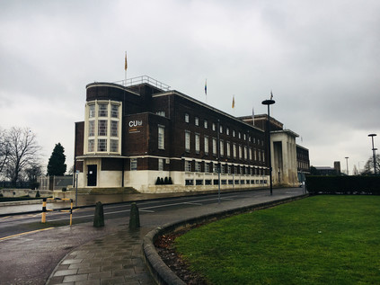
My first impressions of entering the Barking and Dagenham from this new angle were not positive. Wood Lane was a litter strewn and windy chasm leading west, away from Central Park. The development of this area had been carefully planned, but the expected approach was very much from the west. Therefore I first encountered the imposing modernist hulk of Barking and Dagenham's Civic Centre via the less impressive northern shoulder - a rank of white-painted stone window mullions dividing the slab of brick and Portland stone, relieved by a curved glass stairwell on the flank. It was a solid, clean-lined and functional building which looked surprisingly elegant from an advantageous angle, set in a wide and open area which placed it in odd isolation. A chill wind whipped in from the Thames, swirling litter and builder's dust around the grass and flowerbeds which narrowed into a roundabout up ahead. The building was conceived by architect E. Berry Webber as a statement entrance to the nearby Becontree Estate and was ready for use by 1937, roughly contemporary with the completion of the main phases of housing. Webber went on to propose similar plans for Hammersmith's Town Hall very soon after work here was done - but his plans there have been greatly modified by unsympathetic extensions and curtailed by the building of the Great West Road. By contrast, Dagenham's Civic Centre stands now looking largely as it had since opening, despite some less elegant but not overly intrusive 1960s additions. It also appears from the strength of feeling when austerity threatened its continued use, to be a much loved local landmark. On that basis, I was curious what the locals thought of its recent reincarnation as an outpost of Coventry University? Provincial educational establishments gaining a foothold in the capital appears to be very much the done thing now, but taking over a popular local landmark is a bold and ostentatious move. Pondering this land-grab, my route now led away from the Civic Centre, giving unexpected views back across the building and its approaches, which from this vantage bore an unlikely resemblance to a North American High School. The views ahead were decidedly British however as I trudged by the bulky, drab tower of Laburnum House and into the edges of Becontree. This vast estate was developed between 1921 and 1926 on compulsorily purchased former market gardening land, in order to rehouse families from cleared slums as part of a post-war drive to provide homes fit for heroes. Wood Lane, an ancient route which turned south at Becontree Heath, still describes an arc around the bounds of the original development of nearly 24,000 homes which was extended twice before finally reaching nearly 27,000 dwellings by its final completion in 1951. The estate has, at various times, vied for the prize of being the biggest development of housing in Western Europe. Despite the sheer size of Becontree, there is much to recommend about the homes here - solid, mid-century municipal designs which have lasted well, and which are arranged around a reasonable quota of green space. The first tenants of Becontree moved into an isolated, muddy morass with no extant services and a temporary railway running along the future route of Valence Avenue to bring materials to the building sites. Later though, the estate prospered in part due to its proximity to the Ford Works and the belt of industry along the Thames. Initial tenants were carefully screened for suitability by the London County Council, with their standards of hygiene and continued employment a key factor in securing one of these modern dwellings. While the Housing Act of 1919 permitted the LCC to develop these areas and act as landlord despite it being outside their turf, the administrative position around the estate and its cleansing and services remained complex until Local Government Reorganisation unified responsibilities for the site in 1965. Prior to that, various parts of the land fell into the districts of Ilford, Barking and Dagenham with the attendant confusion around schools and services requiring a range of exceptions and easements. While many homes here had long since been purchased under the right to buy rules, there was still a sense of being on a vast estate, and as I deviated from Wood Lane into the midst of Becontree, I was struck by the uneasy feeling of being somewhere which felt very familiar from my own upbringing in the Midlands. The long, straight boulevards of Valence Avenue and Becontree Avenue crossed at the midst of a cluster of local shops which were a little tired and typical, but which were still pleasantly busy. Becontree appeared to be soldiering on through these difficult first months of the year - a little tired, a little wet - but still here.
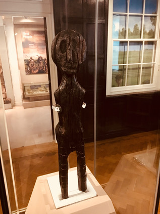
In the midst of Becontree though is a remarkable survival of all this civic and social change. Valence House was first recorded on this site in 1269 as one of the five ancient manors of Dagenham, with the current building noted as standing from around 1400. In 1921 the house, complete with a moat, was still serving as a family home - before being used by the LCC as its local headquarters during the building of Becontree Estate. Between 1928 and 1937 the house served as Dagenham's town hall until the Civic Centre was ready for business at which point the Libraries Department took on the building. The house is now a local history museum, sitting at the north-western corner of the busy park with a small remnant of its moat still separating it from the car park. I skirted the impressive new visitor centre, complete with a sculpture of a rusting Ford Capri marking Dagenham's link with this ubiquitous example of 1970s style, and headed directly for the house. I'd finally come to see something which I'd read about and had been curious to find for some time - The Dagenham Idol. Pulled from the marshes when sewers were being laid along Ripple Road in 1922, the idol is an eighteen inch tall human figure carved from Scots Pine. It was found by workers near the site which was to become Ford's sprawling riverside works, buried next to the skeleton of a deer which was possibly part of the same offering. Carbon-dated to around 2250BCE, the statue pre-dates the construction of Stonehenge and lay undisturbed in a preservative layer of peat awaiting its twentieth-century rebirth. While the rest of the displays at Valence House appeared interesting, especially those about the development and domestic arrangements of the building over the years, I was desperate to see the Idol for myself. After a show of the correct hands-behind-the-back-and-looking-up museum protocol on entering the quiet parlour I turned to the east and found myself looking history directly into its oddly oversized eye-socket. The idol is housed in a glass case in the centre of a panelled area which would once have been one of the fine reception rooms of the house. It gazes perpetually across to the west, eyeing the development of the great city of which its owner may possibly have been a founder. I circled the statue, enchanted by its great age but strange familiarity. It felt curiously appropriate that it had been brought here from its long, solitary home in the marshes into the midst of what had become this vast estate with its apparently unparalleled press of humanity. Would Becontree survive as long as the Idol? It was difficult not to superstitiously link their fates. The idol had reversed Meade's premise and made it out of the "voracious sump" after all.
It was hard to leave the quiet precincts of Valence House and the warm and inviting cafe at the visitors centre, but I needed to make progress and I was aware that the rain seemed to be slowing me down. I left the park and crossed the centre of the estate, aiming for Bennett's Castle Lane - mostly because it described an organic, twisting path on the map through the more regular geometries of Becontree, betraying its pre-estate origins. The lane is marked on early maps of the area, curving roughly southwards towards Longbridge Road - the continuation of the A124 from Wood Lane. The origins of the name are obscure - though on the 1894 revision of the Ordnance Survey map there is both a Bennett's Castle House east of the road near Valence House, and a separate Bennett's Castle nestled into the junction with Longbridge Road. There are no specific records of any sort of fortification - though if the name weren't clearly much older it would be tempting to link it to local industry via Henry Ford's notorious security chief who built a fortified 'castle' in Ypsilanti, Michigan. The lane also marked the boundary between Ilford and Dagenham, a fact blurred by the development of Becontree and erased by the redrawing of Borough boundaries in 1965. Now, Bennett's Castle Lane winds its way towards the edge of the estate in unremarkable style, arriving at the corner which appeared once to have provided its name with little ceremony. I was back on the A124 as it once again became a surprisingly quiet avenue.
Longbridge Road takes its name from a crossing of the little Mayes Brook which, if old maps are to be believed, was well-named. The road appears to run directly above a long, broadened stretch of the water before they part, with the brook heading south towards the Thames. I'd been here before - on a bright winter morning tracing the now largely hidden path of the brook through the urban developments which have filled the once open countryside. The busy curve of road where Longbridge would have crossed the brook is now a difficult to navigate junction beside the Parkside Community Centre. My progress across the street was watched with interest by a small group of locals sheltering and smoking in the lee of the centre like ceremonial guardians for the long-deleted bridge. The brook rose again south of the road in Mayesbrook Park, but my route continued to take me west, passing long, rather fine looking blocks of municipal housing set back from the road. This area appeared to have been developed in the 1930s, with Faircross - where the road south to Upney intersected my route - developing from a tiny hamlet into a busy local shopping area. The walk here was tough going - I was thoroughly soaked now, and the route into Barking seemed endless and unrelenting. I finally arrived at the huge roundabout marking the fringe of the town centre where a modern bypass takes much of the traffic which once passed through the centre of Barking in a northern arc. At the midst of the roundabout was one of the few notable pieces of public art in the district - The Catch - two delicate, silvery metal fishes leaping from the ground in celebration of the historic local fishing fleet, long since decamped to the North Sea. As I crossed the complicated pedestrian route to reach the town centre, I was accosted by perhaps the least successful beggar I've ever encountered. "Gimme one pound cash brother!" he exclaimed, and I turned to see a gentle-featured but huge black man towering over me, his palm extended hopefully. I genuinely had no cash and told him so, but he trailed silently along behind me his shoes flapping at the pavements. From a little way behind me as I paused at a crossing I heard "Gimme one pound cash sister!" - and suddenly the woman whose loud cackling into her mobile 'phone I'd been studiously ignoring turned on him: "Get a fuckin' job, I don't earn money to give it to you, how fuckin' dare you ask me for money. Go to the job centre! Fool!". He didn't seem to find the outburst surprising and padded off along a side-street, lured in by a promising looking crowd hovering outside a takeaway. She strutted away towards town, loudly complaining into her 'phone that anyone would have had the audacity to ask her for money. She held the device away from her face, yelling her disdain into the void between her and the microphone. I slowed my pace, wanting to let her disappear into the busy crowds of Station Parade so I could forget how her twisted, angry mouth had looked as she'd spat her words at the clearly vulnerable and compromised man.
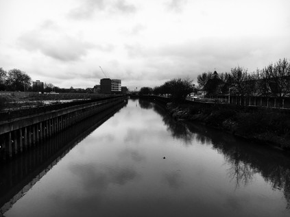
There was a time that Barking was just another stop on the railway for me - a point where routes converged and carefully planned changes between lines were possible. In recent years though, it has become a repeatedly visited nexus on my walks: a crossing point on my journey around the North Circular and a staging post on my walks along the A13 and the River Roding. The Town Centre in particular is all too familiar - a busy, edgy churn of buses and people. Today I passed directly through the centre, finding dodging through a crowd rather challenging after a day of almost solitary walking along damp, suburban avenues. Barking feels like a frontier town - where the attitude and frustration of London crashes onto the calmer shores of Essex. Beyond here, as I'd seen, there were distinct towns and communities, but Barking has been almost completely absorbed by the city - and thus shares in its benefits but shoulders a perhaps unjust burden of its misfortunes. The town is a vestige of a mid-century redevelopment, the busy open-air market wedged into a broad pedestrianised zone between budget chainstores and mobile 'phone shops where it can take forever to make a simple enquiry. The service is low-energy, relaxed to the point of glaciation. Try to hurry things along and they'll move even slower, suspicious of your eagerness to get out into town. The shops are artificially heated sweatboxes which reek of desperation for credit and status. By contrast, business at the outdoor market clips along at a furious pace - bags are spun deftly between fingers to close them, change is drawn swiftly from oily cloth pouches. The discourse is abbreviated: newly arrived accents slipping into the oldest forms of patter without effort. I struck out across the centre of town and wasn't sorry to reach the western edge, where the ancient remains of the abbey stretch along the banks of the river. I paused under the Curfew Tower, the gateway to the Abbey precincts from which a bell would call citizens to douse their fires or suffer penalty as directed by William of Normandy. A 12th century stone representation of the crucifixion is kept in the tower, an object of pilgrimage and a remarkable survival of the destruction of the abbey in 1540. Beyond the tower, St. Margaret's Church remains a place of worship amid its mossy graves and damp churchyard beside the river. I crossed the Abbey grounds, heading for the bridge over the Roding which flowed sluggishly beneath, waters swollen from the rain and tide. The ever-present aroma of mud and sewage drifted along the river as I looked south over paths I'd walked before. Beside the river, the ramps up to the North Circular shuddered and clanked under the weight of traffic leaving Barking under the gaze of another artistic sentinal - Joost van Santen's 'Lighted Lady'. This asymmetrically twisted column of acrylic and light which changes and shifts in colour marks the entrance and exit point of the town, and for me the beginning of the final part of my trek - out of the east and into the 'East End' of legend and tradition.
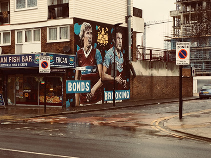
I zig-zagged under the concrete of the flyover and out of Barking, having passed the twin barriers of river and road which separated it from London. From here on, the streets conformed to a victorian pattern of long terraces leading away from the straight road into town. In some ways, this section of my route belonged to my A13 project as the former route of the road had taken this path through East Ham and Canning Town. I realised with some surprise that I was on familiar territory - if from an unusual angle. To the south, Langdon's Academy sprawled along the North Circular - and I recalled striking out along a path edging around it on a previous walk. Meanwhile to the north, the inaccessible scrubland which had barred my way when tracking the Roding south ended in a tangle of unkempt trees and rampant flytipping. I was also crossing into the London Borough of Newham here - one of the proud host boroughs of the 2012 Olympics which seems to be none the richer for its tolerance and hospitality. The road soon gave way to the rows of terraced side streets, named in the Victorian style and with considerable imperial glee for generals, battles and saints. Barking Road was a long-established thoroughfare, no less busy for the building of the new A13 to the south, as it provided access to this vast hinterland of residential streets which marched into the city. I passed the impressive red-brick clock tower of East Ham Town Hall, currently swathed in cloth for repairs but still a landmark on the route into town. Newham Council decamped in 2009 to an anonymous glass hangar on the edge of the Royal Docks in a move which showed a good deal of disdain for the local population which has historically clustered around this area. However, there was a more significant hollow at the heart of this community - a gaping absence where the Boleyn Ground had once stood proudly among the homes and shops. My last interest in football, save for a few notable World Cup tournaments which piqued my curiosity, was on 8th March 1980 when Aston Villa's FA Cup run was cruelly ended in the quarter final by West Ham United. Having listened on the radio in growing disbelief, I remember my hot, perhaps rather spoilt, childish tears of frustration and rage, and a vow not to let this game get me so upset again. I was always an oversensitive soul it seems, but passing a mural of Billy Bonds and Trevor Brooking, I began to understand how this pursuit and the ground which provided a focal point for it had defined this street. With the stands sitting proudly in the midst of this teeming neighbourhood, everything hinged on West Ham - and while it was no doubt the livelihood of many of the local shopkeepers of Barking Road, it was likely the scourge of plenty of locals who wanted a quiet life. The team's ill-fated departure to the Olympic Stadium a year or so back hadn't solved any of these issues and had created plenty more. I vividly remember being evacuated from Stratford on the afternoon of the first match at the rechristened London Stadium - we had strayed in from the industrial hinterlands on a wander around the east, and were swiftly and unceremoniously guided out of the emergency doors and into the Carpenters Estate as a helicopter circled above. The crowds of shoppers dawdling around Westfield were apparently not compatible with a single-minded surge of football fans heading for the hostelries pre-game. On Barking Road, the long parade of shops - the pristinely clean Nathan's Pies and Eels and the Ercan Fish Bar complete with mock West Ham crests - masked the site of the ground, a forest of cranes marking the regeneration efforts. The shops were quiet, pedestrian traffic almost absent. I sloshed along the forlorn street wondering what would become of the businesses here, their ambivalent blessing and curse now gone for good. Would the heritage fetish bring fans back here to their true home, or was it all too late? At the next corner, a statue proudly depicted a cross-section of the 1966 World Cup winning squad, a group of West Ham players who had provided an ongoing engine of national pride which was still recalled in keycodes and passwords generations later - 1066 and 1966 - our defining moments, almost a millennium apart.
I passed into more familiar territory as I crossed The Greenway, that elusive and strange footpath running along the Northern Outfall Sewer which became something of an unattainable prize during the post-Olympic years when re-opening was often promised but never delivered. At its crossing of Barking Road it is running at ground level, usually with long views both east towards the Barking Flood Barrier and west towards the new towers of Stratford City. Today though, there was a flat grey wall of cloud blocking both views. People emerged from the gloom, trudging along the wet path with their heads down. It was good to see the path busy and used though - this stretch in particular had always seemed like a much missed amenity at times when it was off-limits. It was tempting to swing north and west, to head for familiar old landmarks - but I'd decided to press on into Canning Town to complete the sense of entering the city proper, so I pushed on despite my feet aching from walking on slippery pavements all day. Beyond the Greenway, the ribbon of retail units begins which run for the remainder of the length of Barking Road to an abrupt ending where East India Dock Road leaps over Bow Creek. In the distance I could see the cluster of shadowy towers emerging from the gloom on the Isle of Dogs. The road into Canning Town was in transition - and probably had been for years, likely since the closure of the docks. The resolutely homogenous crowds back in Upminster seemed a world away here where old Indian men shuffled along beside swaggering young men with low-slung trousers and Eastern European women pushing prams slowly along the pavements. A shard of red and black glass pierced the gloom - one of the towers which had emerged from the redevelopment of Rathbone Market. Anyone you asked would tell you it was no good - that the old Ratty had been destroyed by the new buildings and the character and charm was all gone - but the community here had been shifting and changing for much longer. The market they missed was in truth the ghost of the one that had been buried long ago, and the spirit of place which is now much closer to the surface in the satellite towns I'd walked in from. As I joined a bus queue which silently shuffled towards a parade of double-deckers emerging from the darkened eastern skies, I considered the area where I'd finally stopped. This spot united many of my excursions and felt almost homelike in its familiarity. I could navigate from here to almost anywhere in the complex network of rivers and roads which I'd memorised accidentally by a seemingly random pattern of walking and re-walking over the years. This spot marked the end of an unremarkable dark ribbon of asphalt snaking in from the edge of things which had wound a steady course through former towns with roots in prehistory, precious unburied idols and the keen absence of more recently diminished heritage. In the growing gloom of the afternoon I boarded a bus to Aldgate, reversing my incomplete walk out of London to the coast which had begun a long time ago, and crossing the boundary of old Essex as I crossed the River Lea. It had been good to be back out east at last.
You can see more pictures from the walk here.
Lost::MikeGTN
I've had a home on the web for more years than I care to remember, and a few kind souls persuade me it's worth persisting with keeping it updated. This current incarnation of the site is centred around the blog posts which began back in 1999 as 'the daylog' and continued through my travels and tribulations during the following years.
I don't get out and about nearly as much these days, but I do try to record significant events and trips for posterity. You may also have arrived here by following the trail to my former music blog Songs Heard On Fast Trains. That content is preserved here too.
