The trip out east had been interesting, despite the dull skies and lightless quality to the morning. I'd rarely used the Underground east of Whitechapel - usually preferring to walk or take the bus - but it was expedient for my plans today. As we rose from the earth at Bromley-by-Bow and scudded over the now very familiar Lower Lea Valley, I picked out landmarks which were in some ways best seen from the train - the silver trickle of Abbey Creek, the green wilderness of Channelsea Island, and the distant curve of currently forbidden pathways. Rising from the Hammersmith and City Line at Barking, the air was damp with flecks of undelivered rain. I sheltered under an awning at the pleasant little coffee stall and watched the morning opening up. The street was busy trying to be unprepossessing: a drooling, Somali beggar hassled us for coffee money and cigarettes, another guy punched angrily at the ATM buttons before turning and vomiting mango-yellow in disgust on the pavement. Across the street the oddly named Kennedy Chicken was opening for business, inexplicably appropriating the unfortunate President's name and bookending it with Liberty raising her torch aloft. Barking was just like I'd always found it - a cartoon version of the 'east end' people think they know, a boiled-down and purified zone of cockney bluster. A melting pot of cultures and interests where you're never really sure it's safe to laugh along with the joke. Finding my bearings, I pressed on through the bedraggled remains of the market, into the older crossroads at the heart of the town. Above me, some fine buildings - and ahead of me the green space of the Abbey Grounds. The remains of the Abbey were deserted and windswept - a litter trap for the neighbouring Abbey Retail Park which spoiled any hope of imagining the Abbey's 13th century glory days or as the seat of power for Queens, Saints and Abbesses. I struck out for the safety of the river - always the best course of action.
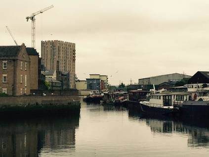
My plan for today was hazy and hurried - but had a couple of focal purposes. Firstly, I wanted to open my account with the River Roding. With my attention almost entirely absorbed by the Lea and its related streams and canals for years now, looking further east has felt almost disloyal to the imaginary scope of my nebulous project. Recently, though as my perambulations have brought me further out of the city, I've looked to find new bounds to prevent my already unmanageable sphere of interest from exploding entirely. The Roding has presented a convenient edge now for a while. After the docks, after the ranks of terraced housing of East Ham there has to be an edge to the map. But of course, every edge demands exploration - a psychic continuation sheet into the unknown. I found the river easily enough - mostly by way of a remarkable smell. The hot weeks of early summer had cooked the Roding into a stinking brew, a mixture of saline, marine notes with raw sewage ported in directly from Beckton on the west bank. At the bridge a flood defence scheme had been constructed, the channels split - one flowing lazily, the other backed up and brackish. Looking north, the river continued straight and featureless, hugging the North Circular and providing a boundary for the retail park and a direct if apparently impassable route to Ilford. To the south it broadened into the town's ancient wharf before contorting into Barking Creek. Rotting barges ranked against the west bank, buffering the car breakers yards of the ironically named Fresh Wharf. The low, grey sky pressed heavily over the estuary, and I was acutely aware of being the only pedestrian for some distance. I also realised that my lack of planning had left me slightly lost and with only a theoretical idea of how to get where I was heading. This was, of course, exactly why I do this stuff....
After a wrong turn onto a high footbridge, which could have shredded minutes from my walk in fact, I headed south alongside the A406. A wrecked Mercedes sat strangely abandoned in a lay-by beside the road - apparently well within the gaze - but outwith the interest - of the permanently manned security booth at the entrance to an industrial park. I edged by the sentry box, expecting trouble but getting none, finding myself in a nature reserve of sorts. What nature would dare come here is unclear - Hand Trough Creek, a gummy inlet of the Roding, lapped at the edge of the path. There were fading information boards and carefully cleared paths - but my route led me in a different direction today. Passing under the North Circular, I squeezed into an alleyway cramped beside the entrance to Newham's 'Central Depot'. A parade of dustbin lorries and odd little golf-cart powered gully-suckers rattled by. The alleyway turned north and hugged the road, taking me to a junction which joined the bridge I'd rejected. Turning west here and edging the grounds of a mid-century prefabricated school, I realised I was walking parallel with a stream or drain. I couldn't find a name for it, but it was significant enough to earn a well-built stone culvert entrance when I final rejoined civilisation at Folkestone Road. The difference here was palpable - firstly, the silence. No traffic moved. The streets were peppered with off-duty taxis and white vans ticking over before their next foray into the suburbs. A light dust of moisture was in the air, and the pavement began to give off their characteristic smell of relief that the heatwave had broken. Near Gooseley's Playing Fields I found my way to a footbridge over Newham Way and into the Beckton Triangle Retail Park. As I zig-zagged up the ramps to the bridge, I noted a pair of joggers looping back and forth over the structure, up and down the stairs, over and back in seemingly endless repetition while the traffic on the A13 shuddered beneath them. After a brief stop at a vast Sainsbury's store for sustenance I set out to find the Greenway. Having walked the western ends of the North Outfall Sewer for some years, this mysterious eastern terminus had always seemed exotically distant - but in truth it all ends at a gateway on a dusty footpath between shopping complexes. Having checked there was no way beyond the fence, I climbed onto the long, straight ridge and began walking west, with the cloying waft of sewage occasionally drifting from below. Beside the path I noted Britvic/Pepsico's manufacturing base and wondered if the presence of the city's filth is why I really didn't like Pepsi so much?
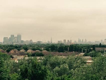
Soon, my second objective came into plain sight. From this direction, little more that a green, wooded tump above the endless sea of off-the-peg white-roofed warehouse blocks. A junction in the path was still signposted for Beckton Alp - but the bridge which led from the Greenway had been removed, the footings still resolutely embedded beyond the fence. I'd expected this - there wasn't any clearly mapped way in from this direction - but it gave me an uneasy feeling about the Alp. It's perhaps not unreasonable to be sceptical about the place - this is the final remains of a toxic heap of spoil which at its ugly zenith stretched all the way from the Gas, Light and Coke Company's works. The heap largely covered the ground which was annexed by the London Docklands Development Corporation for the expansion of the formerly tiny hamlet of Beckton. Now just one, isolated peak of the heap stands, landscaped and neutralised, and for a while the home of an ill-fated attempt to run an urban dry ski-slope in an attempt to capitalise of the long held alpine nickname for the piles of toxic waste. The former enterprise is almost gone, save for a litter of concrete blocks and some wooden platforms. But a zig-zagging path remains, and I chanced upon an unmarked gate in the palisade fence which led to the foot of the climb. I wasn't entirely sure about this - there were few pedestrians around, and it was clear that this gate was locked at points. I slipped inside, and started climbing, doubling back and forth, soon enveloped by the overgrown vegetation. The path was fractured by roots, littered with junk and untamed brambles. It was clear that people didn't come here much - and when they did, almost certainly only to escape or to be unseen. I felt the rising range anxiety - the gate was long out of sight, and the summit wasn't yet evident. As if mocking the Alp's former glory, a rough, steep mudslide of a path took a direct route between the angles of the official route - and for a while I considered attempting the scramble back down. But then, unexpectedly, I came upon a further gate, which was firmly and impassably locked. Above me I could see the tall, iron monoliths which signified the summit. Each was adorned with a splash of ill-executed graffiti which spelled out some kind of coded message to the city: a Star of David, a phallus, the Microsoft Windows logo, a swastika - and finally the inexplicable legend 'Lord Cunt'. I pondered the meaning briefly before turning to catch an unexpected and hazy prospect across the city. Despite the gloom, the low, pregnant clouds and the middle-distance haze, I could make out the gleaming towers of Docklands, the indistinct bulge of St. Mary Axe, and between them the dark obelisk of The Shard. In the foreground, a slash of green and terracotta where Beckton sprawled between the mothballed Royal Docks and the Northern Outfall Sewer. It was time to make a descent, objective only partially achieved this time.
After poking around the fringe of the Alp site for a while, looking for any other potential entrance which might allow a complete ascent, I admitted defeat and braved the complex puzzle of road crossings to resume the journey along the Greenway. I had walked the western end of this permissive footpath topping the great sewer many times, but I'd never quite managed to walk all of it. The Greenway has been partially closed at various points along its length since around 2009 by my reckoning. Firstly it was severed to allow the Olympic Park to be built largely behind blue wooden fences - with a later concession to public interest with The View Tube cafe. Then it was closed further east to allow temporary bridges and widened stairways to be installed in advance of the games, anticipating crowds flocking in from the somewhat distant station at West Ham. The need to dismantle these and remove the Olympic 'overlay' took up more time, and soon enough its most recent closure began - this time to replace the bridge at Channelsea as part of the larger project to dig a new sewage tunnel. This recent closure severs the route from West Ham to Stratford - a ludicrously long stretch given alternative access routes to the path which could have been considered. In any case, the section from Beckton to Balaam Street was new to me. I set out feeling a little apprehensive - I realised my new boots were doing a superb job at calming my feet, which would usually be protesting by now, but were letting me walk far faster and harder than usual. My knees complained bitterly at this treatment, and the long gravel ribbon stretched ahead endlessly. I felt like I'd walked forever, but stopping briefly and turning back I see the imposing tower's of the Barking Flood Barrier at the mouth of the Roding. By a trick of the flat ground and elevated position, they still seem immense and close by, like I've never really escaped from the River. Beside the path, beyond the iron railings and carefully selected hedgerow planting, ranks of suburban terraces stretched across the flat plains between the Lea and the Roding. In the middle distance, the solid diagonal of the Boleyn Ground's terraces - home of West Ham until the Olympic Stadium is ready, bitter years of legal dispute now it seems quieted. Between the pitch and my path, a vast Jewish burial ground edges the Greenway, whilst on the south side, the sprawling modern low-rise blocks of Newham Universtity Hospital parallels the walk. Flanked by death and decay, after being largely alone since leaving the market at Barking, a welcome hint of life starts to reappear unexpectedly - there are cyclists complaining about walkers, and walkers swearing quietly under their breath at cyclists. Bells ring passive aggressively. People join the path with their shopping, schlepping homewards along the convenient direct route. A hoodie-cowled youth dances from foot to foot, shadow boxing and wheeling at an invisible opponent. The Greenway is resolutely alive again as I cross Barking Road into territory I've already covered.
Despite knowing the way is blocked, I walk as far as the fences cutting the path. There is no activity beyond, at least as far as I can see. Below is the slash of waste ground beside Abbey Creek and the railway from which I looked over this territory at the start of this morning's excursion. I descend onto the broad, busy trough of Manor Road, flanked by high walls and dotted with 'Greenway Diversion' signs lifted straight from the London 2012 storeroom. Crossing the street I meet a group of walkers poring over maps, trying to navigate back onto the footpath. They consult the official 'Capital Ring' guidebook and argue about where to head next. There is a degree of hysteria in their voices, decanted into a busy, unknown East London street, off the edge of the sanctioned guidebook. Their walk stopped being pleasantly edgy and urban, and became strangely real as they wheeled out of Abbey Lane. I leave them bickering over directions, and head over the railway towards the head of Abbey Creek. I was here not too long ago, and little appears to have changed. The bridge carrying the sewer is still swathed in plastic, still an apparently work-less work site. I nose into Canning Road again, but find the oddly secretive Mosque has posted sentries. Young men, lazily hanging around at the crest of the street, eyeing strangers and yelling incomprehensibly at those who dare to pass the edge of the site. Channelsea Island is beyond, the huge open swathe of de-industrialised wasteland - one of the last truly empty lots between the city and the docks - subject to dispute. I move on, taking the Channelsea Path into Stratford. I have a minor objective here too - three years back I poked around the Carpenters Estate looking for remnants of the Channelsea north of the High Street, tempted by a tiny remaining slash of blue on a 1995 A-to-Z map. This time I was determined, and although one short open stretch appears to have disappeared under new apartments, by climbing onto the footbridge between Station Street and Jupp Road I could see the line of greenery edging out from under the new blocks and leading into a narrow, algae-filled concrete channel. The river was compromised and diminished, funnelled into this tiny, reeking gap between the Jubilee Line and the road - but it was there, holding out despite the relentless development of the area. Beyond the station it disappeared again, possibly underground - or possibly simply stopped up with concrete. Descending from the bridge, I returned to the High Street and cutting between new-build flats, walked along the edge of the Waterworks River. A new frontage - with sales brochure public art and planting - leads to Bridgewater Road and the concrete bridge still bearing dire warnings for passing under it into the "Olympic Park Work Site". The mouth of the bridge is stopped up for work, while a nearby building being demolished on the river-front teems with artists, tramps and addicts, all vying for a bit of the less-than-prime real estate before it's gone. Oddly enough, this has a little of the feel of how this area used to exist - on the margins of everyone's life, quietly democratic - it's almost nostalgic to clatter uncomfortably over broken down hoardings to return to the pavement.
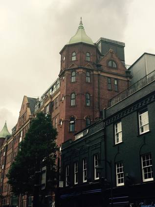
I pause in the park for a while to rest my knees - it's busy, strangely warm, but still weirdly inert. Families queue for the ascent of the Orbit, while others descend and enter the nearby restaurant. There's not too much else to do here just now, but still they come - a tide of pushchairs and toddlers, wide-eyed grins fixed on the slashes of colour of the generously planted meadows. I cut across a grassy area and find it strangely hard going - the grass is coarse, the turfs still separate grass tiles with rough edges. Like an ill-fitting Donald Trump hairpiece, the grass hardly disguises the remediated surface underneath. I linger longer in the park than usual - partly just pleased to find a place to sit and rest after a long unbroken walk from Barking. But also, because I find myself feeling more at peace with the place now. Perhaps it's because the public accesses are starting to open - walkways along the rivers beginning to feel complete, bus routes running through the park - or maybe because the original purpose of the event seems distant now that other mega-events are breaking free of the back pages and becoming predictably bad news? In any case, I miss what is lost, and I wish I'd known it better - but I can at least walk objectively through the park now. I hop gingerly aboard a single-decker heading for Shadwell - I had one last aim which I'd all but decided wouldn't be possible, but which might just work with the assistance of this route. The bus snaked through the park, onto Fish Island and then through Bethnal Green to Whitechapel Road. After a long wait and a perilous crossing of the Cycle Superhighway related roadworks, we plunged into the relative calm of Stepney. I disembarked at St. Dunstan's Church - a little earlier than perhaps I needed to - and after a few yards of crazy zig-zagging managed to get my feet back. I struck out along Stepney Way, using the Royal London Hospital's lofty helipad as my landmark. Despite cutting across the territory endlessly to get elsewhere, I didn't know this triangle of land between Whitechapel Road, the Highway and the City at all well. It had turned warm and humid in the late afternoon, with a relentless sun breaking through the clouds and bouncing back from the glass of the hospital's new buildings. As I entered the old heart of Stepney, there was a sudden and almost magical switch. The streets were lined with Victorian terraces, squares of decent red-brick houses, corner storefronts which were still shops and restaurants. It seemed like a world away from the dry, dusty sprawl of Whitechapel which at times feels like a low-aspiration theme park of urban horror compared to this strangely comforting vision of the Old East End. It was cleaned and primped into modern acceptability of course - the legendary squalor and hardship buffed vigorously away from the streets, bricks scrubbed clean of soot. Then, almost without warning after, executing a deft switch of direction to superstitiously skirt the grounds of the hospital, my objective appeared looming ahead: the great, mullioned frontage of Tower House - formerly Jack London's "monster doss house", now luxuriously appointed dwellings. The old, pointed archway entrance a blank face, its mouth sealed. A new glassy tunnel entered beside the western tower leading to a bored concierge and security gates. As I tried to get an angle for the shot in the cramped narrow street, the woman's entrance of the East London Mosque opened and a silent tide of black-swathed women erupted into the already busy street. I was bustled by the crowd and eyed with suspicion by men waiting in cars which looked not unlike that ill-fated Mercedes I saw wrecked in Barking hours back. I pressed on, camera hidden now from view, skirted the ancient brick wall of the Whitechapel Bell Foundry and made a dash for a bus back to civilisation.
It's hard not to feel cheated in some ways by today's walk - Beckton Alp closed for business, the Greenway still impassible at Channelsea - a long and relentless slog along sometimes reeking byways. But I realise too that as I cross and recross this territory, as I become more familiar with its contours and topography, so it yields more of its secrets. And there are many, many more to be found here it seems.
You can find more pictures from the walk here.
Lost::MikeGTN
I've had a home on the web for more years than I care to remember, and a few kind souls persuade me it's worth persisting with keeping it updated. This current incarnation of the site is centred around the blog posts which began back in 1999 as 'the daylog' and continued through my travels and tribulations during the following years.
I don't get out and about nearly as much these days, but I do try to record significant events and trips for posterity. You may also have arrived here by following the trail to my former music blog Songs Heard On Fast Trains. That content is preserved here too.
