Risings on the Commons: A walk in the South Eastern quarter
Posted in London on Saturday 2nd June 2018 at 10:06pm
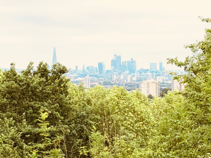
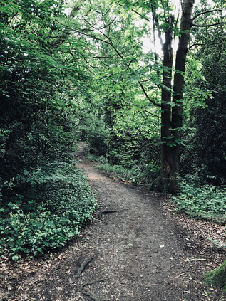
A sweaty clamber up from Honor Oak Park brought me to the top of One Tree Hill, and as the curtain of summer foliage parted Central London unravelled before me. Since the beginning of the ascent from the roadside near St. Augustine's Church I'd been mostly alone - with just glimpses of dog walkers through the trees - and I was glad. Already drenched and with eyes streaming with allergen-sponsored tears, I felt like a mess - and certainly not suitable for public viewing. The tree-framed window through which London was visible swayed hazily at its edges - perhaps the view would have been more expansive in Autumn, but for now I was content to look on a shimmering city of cranes and towers which rose in the middle distance. London abstracted - no visible sign of the chimerism of inequality or the growing concern about violent crime amongst young people which seemed to be the dominant narrative now. This was an unreal city which, from these southern slopes at least, appeared to be a painted backdrop. I'd meant to come to One Tree Hill for a long time - intrigued by the name, and directed here again by a recent episode of the excellent London's Peaks podcast, I'd finally found the route to fit the urge. My recent walks had occupied me in the south-eastern corner of London, which while something of a diversion, was not unprecedented. This fringe territory where endless suburbs blur into the edges of provincial, unreconstructed Kent had interested me for a long time and the views east from the Thames foreshore were always a draw. So, I'd scored a hasty and uneven line roughly north-easterly along the map - connecting One Tree Hill with my recent travels and roughly approximating the tangled and somewhat unloved Green Chain through South London. The day stretched ahead of me, sweaty and pollen-flecked. It was time to set off...
Before I left One Tree Hill I wandered the top of this significant peak, circling the concrete base of a First World War gun emplacement which sat at the summit to counter zeppelin raids. Sometimes more prosaically known as Honor Oak Hill, the hilltop has been strategically significant for some time, with an East India Company semaphore station established here in the eighteenth century, and the provision of a warning beacon during the Napoleonic Wars. The single tree after which it is named is known as the Honor Oak - where legend has it that Queen Elizabeth rested on her journey to Lewisham, and for centuries a marker of the southern extent of the Honour of Gloucester. This vast feudal estate comprised 279 manors by 1166 when the tree would have been situated in the midst of the still impressive extent of the Great North Wood. The hill later passed to the ownership of the Abbots of Bermondsey before the Dissolution of the Monasteries put paid to their tenure too. The slopes then took on a largely unremarkable existence, with little attention paid to their frequent but informal recreational use until 1896 when the local golf club attempted to enclose the land with a six-foot high fence to deter the locals. The formation of the Honor Hill Protest Committee - including numerous local dignitaries - soon followed, with the aim of protecting the public right of way to walk on the hill. The interminable administrative process of dealing with numerous landowners and vestries threatened to drag on for far too long for a number of local folk who on 10th October 1897 broke down the fence and stormed the hill. A reported crowd of 15,000 dispersed peacefully after singing 'Rule Britannia' at the summit. A week later with ranks swelled to over 50,000 the mob was more unruly, with stone-throwing and fire-setting taking place. Ten were arrested for trespass and fined or imprisoned which appeared to successfully quell these guerilla tactics. However, the protest continued through more ponderous legal channels, not finally being resolved until 1905 when the recently formed Borough of Camberwell purchased the land. The view - once claimed by Sir John Betjeman to be "As a prospect [...] better than that from Parliament Hill on Hampstead Heath" remains impressive - and with this last outcrop of the range of hills which climb steadily from Croydon being visible from some distance, it is no suprise that it has attracted a mythology - from Boudicca's last defeat to Dick Turpin's look-out.
I skirted the foot of the hill via the woodland path which wound between the trees, shadowing Brenchley Gardens. This broad, curving road sat on the embankment of the former railway branchline to Crystal Palace which I'd encountered previously on the South Circular. Beyond the railway alignment in in an unlikely symbiosis, the vast underground Honor Oak reservoir was covered by the well-kept greens of the Aquarius Golf Club. Glimpses of the view across the Thames filtered between the buildings as I followed the road to the gates of Camberwell New Cemetery. I passed the through imposing white-painted gateway and walked the ceremonial route towards the Mortuary Chapel - a rather traditional ecclesiastical-looking building by Sir Aston Webb and his son, Maurice which opened with the cemetery in 1927. A path took me towards the more impressive Crematorium by Maurice Webb working alone which was built in 1939 in a modern style with a fine square tower and stained glass window. While the bereaved rolled up to refresh flowers and tend graves, it felt strange and perhaps wrong to photograph this building, but there was a curious life and buzz about the place which prevented it becoming entirely macabre, assisted by the fact that the paths of the cemetery were surprisingly well used by those heading for the nearby recreation ground in football colours for a junior match of some apparent importance. This corner of London - not quite Forest Hill, not quite Peckham - is a strange city of the dead with the former boroughs of Camberwell and Lewisham both locating their respective Necropolis on the line dividing their turf. The tracks of the railway lines to Brighton parallel the old administrative boundary, occupying the former route of the ill-fated Croydon Canal, and I crossed their deep cutting via a slightly forbidding footbridge and entered the often overlooked village centre of Crofton Park. This suburb on the site of the original hamlet of Brockley largely exists only because of its own small and somewhat unloved station on the lines into Blackfriars. Near the station, the Rivoli Ballroom stands resolute - the last extant example of the opulent and somewhat kitsch dancehalls which would have graced almost every suburban High Road in the mid 20th century. My route continued east via the long curving route of Brockley Grove, a pleasant street of decent houses which faced the tall, swaying uncut grass of Brockley and Ladywell Cemetery. Formerly separated by a wall, these two burial grounds opened within a month of each other in 1858 as Deptford and Lewisham Cemeteries respectively, and didn't finally become a single cemetery until 1948. Given their proximity to the Naval Yards of Depford, both feature a number of nautical burials, not least that of William Rivers who was killed by 'falling from the maintop of HMS Sapphire at Hobart Town on November 5th 1877 aged 19'. Now the wall separating the two sites had fallen, and both had returned to nature to a great extent - but at the Ladywell end a rather grand iron gate still worked hard to outshine its neighbour.
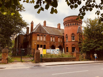
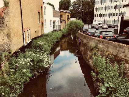
Stately Brockley Grove dissolved into Ladywell Road and once again I crossed one of the imperceptible lines which divide South London communities. The road began a gradual descent into the valley of the Ravensbourne via a ladder of terraced streets leading south, all given clumsy-sounding compound names to honour the Victorian builder's sizeable flock of children: Elsiemaud, Amyruth, Arthurdon and so on passed by as I trudged towards the much-gentrified centre of Ladywell. I quickly recognised the pleasant little village around the railway station from a previous walk, but I hadn't noted during that riparian approach just how jarring the transition was from a proud but struggling mainly black neighbourhood into the resolutely white hipster-magnets of the bakeries and taverns which clustered around the bridge. Beneath the road, the River Ravensbourne gurgled in its concrete prison while the heat which was now beating down on the tarmac made the cool flow of even this beleaguered watercourse seem oddly attractive. I moved onward, descending from the bridge and soon leaving Ladywell to enter the hinterlands of Lewisham. I hadn't originally intended to head this way - my plans suggested a route further to the south, even perhaps rewinding part of my perambulation around the South Circular - which felt less than edifying today. But the need to find a drink had driven me towards civilisation which was perhaps no bad thing. The route also led me past the remarkable Ladywell Bathhouse. More lately known as the 'Playtower' this remarkable survival of a 19th century swimming pool and bathing facility is part of a cluster of former civic buildings beside the Police Station and Mortuary buidlings. Erected in 1884, and designed in part by the local architect Thomas Aldwinkle, the building was remarked on by the Kentish Mercury as 'quite an ornament to the neighbourhood, standing in striking contrast to the ancient church behind it. The building has a remarkable local history - having hosted record-breaking swimming champions, political meetings, Olympic standard gymnasts and finally a play centre until final closure in 2004. Since then the building has decayed and suffered arson attacks - to the extent that it was named one of the ten most at risk buildings by the Victorian Society in 2015. Boarded up and abandoned, the building awaits its fate - which more optimistically appears to be conversion to a Curzon cinema sometime soon.
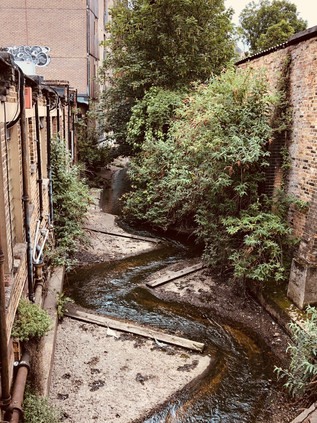
After the rather quiet civic island on the outskirts of town, the sudden rush of Lewisham High Street was something of a shock. Traffic pulsed through the lights, and I tried to plan my next move while navigating the busy pavement. People stood around outside shops as if stunned by the sudden heat, and I slalomed around them in an attempt to find somewhere to stock up on liquids before taking on the steeper hills later in the walk. My initial plan of dashing across the street and back into the suburbs was soon abandoned - this stretch of High Street had little to offer and I was forced to head for the centre of town. The skyline was a broad frieze of blue sky and tall cranes - the same knot of new buildings I'd seen from the river on an earlier visit. Close up the new developments were uninspiring and formulaic: stacked geometries of primary colours and too-clever angles. Names were to be assumed by interpretation from some ancient use of the ground on which these new buildings sprouted, resulting in a proliferation of granaries, mills, stables and the like. A little way to the north, the High Street divided around the gloomy brick stacks of the former Riverdale Centre. Dating from 1977 this surprisingly large shopping centre is due for an upgrade soon, and in some ways is remarkable in retaining considerable footfall despite new developments nearby which have effectively killed-off similar centres around the capital. That said, the offer here was in the mid-to-lower sector of the market which was echoed in the drab facades of the clearly struggling High Street which glowered across at the centre. Between the run of bus stands and the stores, a steel band belted out music to a heat-subdued crowd which nodded and shuddered lazily to the irrepressible clamour. I swerved onward, finding myself at the unprepossessing corner of Lee High Street. A wall of buses waited to turn the corner, and I wondered if I'd made the right choice of walk today. The sun had dipped behind low cloud and the air had become a sticky, fume-laden soup which coated the inside of my dry mouth unpleasantly. I withdrew cash but couldn't find anywhere to spend it - Lewisham had almost defeated me. It remained an overheated and frustrating mystery - and just as confusing and unwelcoming as it had felt on my previous brief passes through the territory. Perversely, I wanted to understand the place even more as a result. The road ahead - the A20 - which was still somewhat anachronistically signposed 'Channel Tunnel' swiftly became a typical London escape-route which could be at any corner of the compass with the ubiquitous ranks of hair salons and kebab shops tumbling along both sides. Preparing for a dull stretch of walking, I glanced along the oblique junction with Clarendon Rise and was stunned out of my mental grumbling. Firstly, a beautiful Hindu temple stood rather surprising among the garages and back-entrances, set a little back from the road and in a tight, corner site. The decorative plaster front dripped with carvings and reliefs, the gable divided by an impressive stacked tower which glinted above its drab surroundings. At ground level beside the temple a faded blue railing signified water. I've come to know these tell-tale gaps in the streetscape well and always investigate them for potential brooks and streams. Sure enough, trickling grimily below the road the Quaggy River snaked out from under Lewisham and headed east. This gave my walk something of a new energy - and I struck out with a little more effort than I'd managed on the last stretch.
The Quaggy soon slipped out of site. Forming the boundary of back gardens and mediated by flood relief schemes, it is an anonymous river for much of its course. My own first encounter was years ago at Lewisham Station where it passed below the platform in an unremarkable concrete culvert helpfully accompanied by an Olympic-funded information board. Here though it was still cocooned, but it felt wilder and intruded somewhat more on its surroundings. The land dipped towards its shallow valley, and the street patterns followed its torturous curves. The Quaggy was still making its mark it seemed. I pressed on via road, following the straighter route while the river looped lazily to the south. I could have deviated away from the road and headed for Manor Park, but I was confident I had the river in my sights again. Sure enough, as I poked around the outskirts of the Sainsbury's at Lee, the river again appeared passing under a nondescript bridge nearby. Its neighbours had built a platform to sit above the waters beside their business, and it was hard to tell if this was a slight on the apparent unimportance of the river or a genuine attempt to make the most of otherwise urban surroundings. Once I finally found my way into the store, I shopped swiftly and considered my options - I could try to approximate the route of the Quaggy, ending up at the South Circular a little further away than I'd hoped - or I could use it as a loose guide and strike out into the uncharted private avenues of the Cator Estate? I opted for the latter, disappearing into the leafy and primped Manor Way and soon feeling unpleasantly oppressed by the experience. Once past the gates and the rather disapproving glare of the red-brick gatehouses the road was straight and dull, lined on one side by ranks of pleasant and expensive looking homes while to the south the land fell away to become Blackheath Park on the banks of the Quaggy. Much of my walk through the estate of John Cator (who's other lands I'd encountered before) was spent worrying about finding an exit or being turned back to the start by an overeager security guard. In the event, the exit showed up first - after passing a little extension to the estate posed around an ornamental lake formed from what appeared to be the sometimes elusive Mid Kid Brook stream, a grim access path led away behind a block of untidy garages next to the less salubrious homes of Casterbridge Road. Here I noticed a phenomenon which had seemed at first unlikely but for which evidence was now harder to ignore: the endless parade of 'Saturday dads' walking or wheeling their children along the quiet afternoon roads. Across Lewisham and Ladywell I'd seen the same parade - a faintly depressing sense of resignation on the faces of the pushchair driving men while their offspring chattered excitedly or dozed in the heat. I sensed the frustration and defeat of many of them, among sometimes more hopeful scenes. Aware of my perhaps unfair assumptions, I took my spot in this parade and slalomed along a much-diverted path through a development zone bounded by view-defying temporary wooden fences covered in computer-generated scenes of urban paradise. I need not have worried about finding a way out - the proprietors of Kidbrooke Village really seemed to want me to head this way and to see all of their promotional material...
And so I found myself in one of the most uncanny zones of London I've experienced since those heady pre-2012 days in Stratford. Put simply, Kidbrooke Village didn't exist, despite the best efforts of Berkeley Homes to convince me it was here. This was the site of the Ferrier Estate. Constructed between 1967 and 1972 by the Greater London Council, when completed the estate consisted of nearly 2000 homes in eleven 12-storey prefabricated blocks and associated low-rise units linked by walkways. Perched on the edge of resolutely White British Greenwich the estate didn't fare well and became a convenient spot to manage demand for social accommodation by the flawed strategy of housing many families who were on the margins of the Borough's population on the same estates. A combination of sharply increased numbers of refugee families, a dizzying mix of languages and ethnicities and a policy of generally abandoning maintenance and improvements meant the fate of the estate was sealed. It was often mentioned in the same breath as the other two inconveniently troublesome South London 'hell holes': Heygate, Aylesbury, Ferrier. Only total erasure would exorcise these failures of policy - at least in the minds of those who had, in some cases presided over their construction. And so they fell, and thus by 2012 much of the old estate had gone and Kidbrooke Village had moved from a hazy, watercolour sketch on a drawing board to a concrete plan. Meanwhile the Ferrier residents were being scattered around the capital and beyond. Berkeley were going to do this differently, however - they'd build a community, not just houses. And so in the midst of the landscaped wetlands which may or may not be fed by the vestigial waters of the Kyd Brook, the 'Village Centre' squatted the corner of a modern block. Looking worryingly temporary in nature, the doors were closed today. Few people were around, and while I unenthusiastically downed an unripe banana, only a few more dads and a powered-wheelchair passed by. I located a waste bin - pristine and empty of course - and headed east towards the station. The parcel of vacant land between the railway and the village was being slowly filled in - a new academy and more housing were promised on the glossy hoardings surrounding the plot - and the road onward was lined with scaffolded blocks awaiting their final fit-out. It struck me here that Kidbrooke was no more - the station served the new village, but any sense of a historical Kidbrooke had been erased. The suburban hinterlands stretched away north - but the place had been bypassed twice already, and the focus had shifted south. I navigated the pedestrian subways under the confusing junction where the improved route of the A2 bucked and reared northwards towards London noting there was no indication of how far away Kidbrooke was on foot among the direction signs. In fact, this spot in the underpass may as well have been the real village centre - and indeed perhaps once was?
The footpath emerged from its cool, green tunnel at Kidbrooke Green Park. This parched lozenge of parkland bounded by the old and new routes of the A2 was scattered with sunbathers and dog walkers who didn't appear to regard their local bit of respite from the suburbs as a historically important scrap of ancient wetland at all. This remaining corner of the former village green is evidence of a set of historical compromises which could have led to a very different landscape hereabouts. Kidbrooke as a suburb is a recent development, having largely grown up along the route of Rochester Way - a bypass for Shooter's Hill which offered traffic a flatter, less taxing route out of London from the 1930s, slicing into the green in the process. The remains of the village green were then later proposed as the location of a vast interchange between the southern and eastern flanks of The C Ringway - the urban motorway which was to have connected the North Circular to a replacement for the South Circular. This road would then have turned east and scythed an utterly destructive course through South London's suburbs on a viaduct. Little of this road was built, but evidence of the extent of its impact can be seen in the strips of new development which fill in the once reserved motorway corridors which languished while the plan was debated by the GLC and the Boroughs. The complex twist in the A2 here also gives a clue as to how much would have been entirely obliterated by the South Cross Route as it ploughed west towards Brixton and Camberwell. The plans were not popular with the London Boroughs, and in particular were fought bitterly by Eltham and Greenwich, and despite a number of proposed concessions they were finally buried with the remains of the inner Ringway plans by 1973. The people of Kidbrooke likely have the residents of Blackheath to thank for this, as the organised opposition to the devastating destruction of shops and homes in their village forced consideration of a cut-and-cover tunnel which delayed construction and escalated costs to unsustainable levels. There may not be much of Kidbrooke's Village Green to see now - but there could have been far, far less. It was becoming extremely hot walking weather now - and I clocked the temperature at approaching thirty degrees as I crossed the yellowing grass of the park and emerged on Rochester Way. The long straight carriageway shimmered in the heat between its generous pavements and wide verges. This was classic London arterial: a textbook example of how roads into and out of town were envisaged in the earliest days of the motor age. I set off, fixing my eyes on the wooded slopes rising in the near distance. I was keen to get back under the trees and to shelter from the overbearing sunlight as soon as I could. The ribbon of tarmac unravelled endlessly ahead - a modern-day Watling Street on which surprisingly little traffic bothered my ears. A bypass that had been bypassed already, its lifespan as a major route ended by the wider and louder A2 which was still within earshot to the south, offering a thrum of white noise to the still and hazy afternoon heat.
A diversion into the quiet side streets had given me an initial hint of how steep the ascent would be from this direction, but I wasn't fully prepared for the slope which rose between houses to climb a meadow and disappear into the trees. Shooters' Hill had been a challenge last time, but approaching from the south the ascent was steeper and less forgiving. I fixed on a bench halfway up the rise towards the crest and leant into the climb. As I approached I noticed that a family had set up their picnic under the trees opposite the bench, and my British reserve wouldn't allow me to collapse sweating and panting just feet from their chosen spot. So I pushed on, suppressing my heavy breathing enough to pant a hopefully nonchalant and breezily casual 'Afternoon!' as I trudged by. At the top of the hill I found a fallen tree I'd been aiming for had just been alighted on by a cackling and capering gang of exchange students with lurid backpacks and packed lunches, so I leaned against the cool trunk of a venerable tree and rested, surveying the panorama of South London which was revealed from this height. The view southwards often feels less impressively sweeping - perhaps because the hillier terrain of the south doesn't permit the same vast panoramas seen toward the north. It struck me however, under the canopy of ancient woodland here, that there would once have been a sea of treetops as far as I could see - the Great North Wood stretching south into a hazy green distance. I turned back to the climb, wanting to find my way deeper into Oxleas Woods. The footpaths were busy with families, a distinct aroma of sunblock and ice cream preventing me from feeling like I was truly treading ancient byways here. Nevertheless, the woodland paths felt surprisingly wild in places and I was able to head deeper and lose myself in the greenery. The mossy trunks and ceiling of foliage tinted the view green, and kept me pleasantly cool while the path crunched with fallen twigs and seed pods. I slowed my pace to enjoy the cool respite offered by this venerable swathe of woodland. In the process I managed to regain both composure and a reasonable core temperature, at least until I emerged in the remnants of formal gardens which had belonged to one of the large properties which once flanked the woodland where the sun beat down on me once again. The water tower at the top of Shooter's Hill dominated the view - and I soon found myself near The Bell once again, waiting to cross the busy flow of traffic and looking back over the scene of my recent walk in from Kent. My aim now was to further retrace that route, at least as far as the Shrewsbury Tumulus. I wanted to take the mysterious route of Mayplace Lane down the hill towards the Thames. Sure enough, the curious little track was waiting beside the swaying grass on the burial mound, just as it had apparently waited for time immemorial. My oldest maps of the area show the lane bending to the north and slightly east, resolutely retaining its route as generations of new development slowly surrounded it. The street signs suggested the route was not suitable for vehicles - and in fact it appeared it was also not ideal for my aching left knee which clicked and popped ominously as I began the descent on the winding lane which provided a rutted and uneven service road at the rear of properties on Eglinton Hill. I marvelled at the driving skills of residents who apparently managed to get their cars along this track and into the various garages and gardens which backed onto the route. The lane headed steeper down hill, crossing several roads of Victorian terraces which had remarkably allowed this old route to cross unhindered. I was amazed that the unsentimental and economically-minded builders of that era would have willingly left a house unbuilt on each road to accommodate Mayplace Lane. Eventually the route gave up at the foot of the hill near the shops on Herbert Road. The tall, brick blocks of the somewhat infamous Barnfield Estate loomed over the end of the lane as I made my way between buildings and back to more modern carriageways, glad to have followed Mayplace Lane - but still intrigued to know if it had ever reached all the way to the Thames?
I was now heading east again along Plumstead Common Road, which was surprisingly congested and difficult to cross. My aim was to walk a short distance along the road before getting swiftly off the pavement and onto the Common. As I approached I noticed the grass was busy with sunbathers haphazardly scattered across the generous green area which had, like One Tree Hill been hard-won. The Common has a long history of public use, being mentioned in the Domesday Book as Plumstede - a place where plums grow - even then known as common land used for grazing. As the Royal Arsenal expanded operations at Woolwich, large swathes of the Common were secured from Queens College, Oxford who owned the land, to provide space for workers' homes. The coming of the railways rapidly accelerated this process of building new suburbs, and In June 1876 the local populace began to take action to defend their ancient rights. These protests caught the attention of the Commons Protection League and charismatic and radical Irishman John De Morgan in particular - and on 1st July, under his leadership a crowd of 1000 people stormed the common, tearing up illegal fences and marching on the home of Sir Edwin Hughes, local Member of Parliament and at the time, also leader of the Conservative Party. De Morgan was arrested and jailed for seventeen days, but the increasing pressure on local politicans resulted in the passage of the Plumstead Common Act in 1878 and the purchase by the Metropolitan Board of Works which has resulted in the area remaining protected to this day. Near a rank of well-used tennis courts I paused to rest, watching a mysterious black-clad young woman undertaking some sort of outdoor art-project involving a huge carpet of taped-together paper and spray-cans on the footpath nearby. A little way across the common was the football pitch where Arsenal FC had played their first games, originally as the 'football division' of Dial Square Cricket Club, founded by the workers of Woolwich Arsenal. Much had changed on the common since then, and the tiny café next to the Old Mill public house was now 'The Plumstead Pantry' with a nice line in artisan coffee and exclusive baked goods. As I trudged by, glancing up at the brick tower of the windmill which remained in the grounds of the nearby pub, a young customer pushed by, busily devouring a croissant in a cloud of pastry dust and swaggering across the width of the pavement. He paused to glug greedily at a thimble-sized cup of coffee, so I made my escape- scooting by and getting on my way as swiftly as I could. The Common stretched to the east - an impressive swathe of land had been secured by those protests including a spot intriguingly marked on my map as The Slade Ravine. I followed the path rather skeptically, thinking that something as impressive as a ravine would surely have made it into the mythology of London which I'd been reading for years? The path dipped into a tunnel of trees and became a flight of steep stone steps, and two things became apparent: firstly that there was genuinely a ravine in Plumstead Common, and secondly that I'd likely to have to clamber up the other side of this rather deep impression in the landscape! At the bottom of the ravine a series of ponds separated by weirs and filter beds provided a cool, green-shaded haven for wildlife. This strange, venerable place deep in the earth felt safe and hidden, even from the now overbearing heat and the drone of traffic on Kings Highway nearby. Formed by a glacier melting into a fast-flowing river during the last ice age, The Slade was now a dry gully carved deep into the land, dividing Plumstead Common from Winns Common where a Bronze Age burial mound is all that remains of an established dwelling which endured through Roman times. Winns Common was reinhabited briefly after the Second World War when a village of prefabricated homes housed the Blitzed and displaced folk of London. Generations of settlers would have known this spot, and unlike its surroundings, it would have looked remarkably similar to them too.
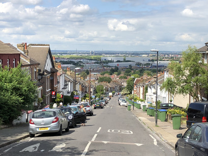
I struggled up the steps out of the ravine slowly, noting another walker following me and picking up my cue to take things equally steady despite likely being a good deal fitter than I. I collapsed onto a nearby bench and tried to look nonchalant as I consumed the last of my water and decided what to do next. I think my fellow sweaty and exhausted walker was jealous of my bench, but there were others to be had not far away! My plan had been to tackle Bostall Hill and descend on Abbey Wood via the site of Lesnes Abbey - but that would have to wait. Another ascent in the blazing sunshine was a little too much to contemplate just now. Instead I decided to strike out for the same spot by staying on the flat as far as I could. After crossing Winn's Common I began the descent towards the Thames, my knee now making genuinely ominous noises as I shuffled downhill passing by a series of geologically-themed squat tower blocks: Crystal, Galena and Marble House. All of them were prematurely decked with the St. George Cross in anticipation of a World Cup to come. From this vantage point the floodplain of the Thames opened out impressively below, with the near distance occupied by the Crossrail depot and the curious industrial estate-like anonymity of HMP Belmarsh, home to Britain's most violent and prolific offenders. Flanked by its sister prisons, HMP Isis and HMP Thameside, all three looked like innocuously vast branches of B&Q from this safe distance. At the foot of the hill, Plumstead High Street pulsed with heat and shuddered with car stereo basslines while we all waited time at the junction with Basildon Road. Fumes and dust hovered in the air, and I was glad to reach an opportunity to turn into the side-streets and zig-zag towards Abbey Wood station. My spirits and my feet had rallied now that the end of the walk was in sight, but swiftly fell again when I spied a bus heading my way marked 'Rail Replacement Service'... I may not have needed to plan this walk extensively, but I had - embarrassingly - left some of the key details unchecked it seemed. I swiftly replanned - and noted a regular bus service from outside the currently closed station which made a circuit of Thamesmead before depositing passengers at Plumstead station, the current extent of operations on the line. This local service seemed infinitely preferably to a slog through the same clogged streets I'd just walked on a hot bus full of disgruntled would-be rail passengers. A short wait followed, before a small group of us were whisked away by a single-decker which navigated the intricate web of roads through this vast and relatively late-come suburb of London. As we passed over the Southern Outfall Sewer at Eastern Way I was able to orient myself by way of an earlier walk in similarly hot weather. After observing the other-worldly architecture of the original concrete blocks and walkways of Thamesmead passing by, I settled into my seat for the remainder of the ride, before joining most of the other passengers on a dash around the corner for a waiting train at Plumstead station.
On the run back over the South London rooftops I pondered today's walk. Everything felt strange and temporary just now, uncomfortably close to the brink. My thoughts and indeed dreams were plagued by decisions I had little power over. This was the perfect antidote - a walk to connect points which had become increasingly familiar, but one which didn't have a definite purpose. With no river or road to follow and no fixed itinerary, I'd failed no-one by turning aside here or there: being seduced into tracking parts of the Quaggy River in Lewisham, but abandoning it to explore the lost suburb of Kidbrooke or even my final diversion away from the route in Abbey Wood. Instead, I'd walked off a little of my anxiety, letting it evaporate into the heat as I let the byways of London take me largely where they chose. I thought back to the moment on the top of One Tree Hill, gazing out over London as an unreal, painted city. I thought too about the protestors who had gathered at One Tree Hill and on Plumstead Common to protect my future right to walk on unspoiled greenspaces within London. The backstreets of Lewisham felt more solid and dependable than any panorama just now, and a bit of steadfast reality was just what I'd needed today.
You can find a gallery of images from the walk here.
Lost::MikeGTN
I've had a home on the web for more years than I care to remember, and a few kind souls persuade me it's worth persisting with keeping it updated. This current incarnation of the site is centred around the blog posts which began back in 1999 as 'the daylog' and continued through my travels and tribulations during the following years.
I don't get out and about nearly as much these days, but I do try to record significant events and trips for posterity. You may also have arrived here by following the trail to my former music blog Songs Heard On Fast Trains. That content is preserved here too.
