A Solid Mass of Heaven: A Weekend in The Borderlands
Posted in Travel on Sunday 31st March 2019 at 9:03pm
The drive into Wales was fractious and slow. The motorway was mired in congestion and overwhelmed with traffic, so we slalomed across the map heading steadily westwards on a successively narrower corridor of minor roads, a routing which made me - the navigator - distinctly unpopular for a while. Skirting major towns and curving along wooded channels, there wasn't much of a view beyond the monotony of a white line and the the threat of oncoming traffic. Finally, the valley opened before us: Hay Bluff glowered over the scene from the south, while our road briefly skirted the little town of Hay-on-Wye before heading into the countryside again. By a series of lucky turns and informed guesses we made our way to Glasbury-on-Wye and The Grange - the quiet bolthole we'd found for the weekend. It was good to get away - life had felt pressured and a little off-kilter these past few weeks. We were adjusting to new routines and new challenges, while integrating the same old pressures and stresses into a world where we both worked for the same employer. Escape felt well-earned and rare, and the fine old farm house with its casually friendly hostess and loping guardian hounds who were far too friendly to truly defend the place. We were instantly comfortable here, and celebrated by escaping to the local hostelry for too much food and wine. It was good to be in the Borderlands.
But this trip was also about exploring, and I was out early the next morning to make the walk beyond the pub and into the tiny hamlet of Glasbury. At the meeting of roads near the gateway to the common, I found a familiar sign: 'London Borough of Redbridge'. Oddly out of place here, the distinctive emblem and bold, plain design struck me first. I was transported to distant walks, connected strangely back to my wandering in the capital. Since 1963, the borough had sent groups of students - sometimes up to 1800 each year - to Glasbury to experience the outdoors and particularly the opportunity to canoe on the Wye. The future of the centre was first threatened in 2011 when subsidies fell, and it finally closed its doors in 2015 with the Borough seeking a £1 million receipt for the property against a challenging savings target. The building stands, decaying and apparently unsold while the signs still show the anomalous ownership. Instead of the fast-running Wye, the young people of Redbridge will be encouraged to enjoy the comparatively local Fairlop Waters instead. Having walked their edges recently, I can testify to the impressive sweep of the park and the windy lakes certainly looked well-used by boaters. But were they a substitute for the adventure of a journey out here? It was sad to think of this decades-old trip to the mysterious valleys no longer taking place.
The Wye is broad and shallow at Glasbury, and I crossed the gravelled strand which led to its banks under the shadow of the road bridge. The river had scoured deep holes near the piers of the bridge which formed deep, dangerous pools requiring care in navigating a route under the carriageway. North of the bridge the river curved gently eastwards towards Hay, dividing into multiple streams and rejoining, and later we would set out in the same direction. My last visit to Hay was lost in a haze of confused sixth-form memories. We were brought here to experience the 'town of books' and to delight in the ramshackle cottage industry which presented its charming face in the old town. I didn't quite appreciate the rather ragged, hand-to-mouth existence of bookdealers then. Even these comparatively well-to-do country types existed in a world of unlikely fellowship and bitter competition. We'd get to see that a little on our excursion: enquiries after Beat Poetry in the wrong store incurred wrathful spitting of another bookseller's name. Try him. He likes that sort of stuff. We'd duly shuffle on, each with only a few pounds to spend on wretchedly ill-used paperbacks, hustled away from the glass-fronted cases containing the really good stuff. Don't even look. That's not for you. We scaled precarious spiral stairs to look an unsorted stacks of remaindered novels, and clattered into dank basements full of songbooks and sheet-music. It was both wonderfully educating and deeply depressing. I've struggled with second-hand shops ever since. Not until a visit to Powells in Portland years later would I even dare to seek out authors I cared to find works by, always feeling so utterly deflated by the sheer volume of pulped print around me. This trip was also one of the few times I got into any real trouble at school... On a brief stop in Cheltenham on route to Hay I'd strayed into Our Price records, and came away with a 12" single of 'Fishes Eyes' by New Fast Automatic Daffodils using virtually all of my spare cash. Later, we were ushered by our English teacher into a queue under a damp marquee, each of us duly bound to line up, purchase a book of poems and have it signed by D. J. Enright. Enright was virtually unknown to me then, aside from being the editorial credit on a number of anthologies. From what I'd seen of his work he didn't belong in my naïve, resolutely teenage canon. We shuffled forward, the better-prepared clutching their Collected Poems while the more thrifty held slimmer volumes. The author, heavy browed and bowed with age and likely boredom, smiled generously and signed almost unintelligibly. I assumed poets must all have terrible handwriting. I realised at some point in this slow procession towards Enright that I had neither book nor the funds to purchase one. I clutched the signature red 'Our Price' bag conspicuously, wondering how to play this? Despite my haughty assumptions, Enright was truly an impressive figure: I didn't know of his long sojourn overseas and the near international incident he'd caused in Singapore, I didn't know of his loose but important association with 'The Movement' and that last gasp of an older school of serious British writing. All I knew was that my literary pretensions lay elsewhere, and that my wallet was empty. I shuffled in front of the author in my turn. He smiled benignly as I offered him the New Fast Automatic Daffodils record. He examined it with a wry chuckle and said he'd not expected to see this. Eventually he took us his pen, scribbled something on the cover and handed it back with a gruff laugh before turning to the next in line. As I wandered away to inspect the record, I felt the eyes of my disgusted English teacher following me across the marquee. The inscription read:
I take no responsibility for the contentsD J Enright
I was suspended for three days as I recall.
Our day in Hay-on-Wye was very different: we found great coffee in the Old Electric Shop which combined café and retro furniture sales, strolled around the busy town and explored both a shop devoted to selling maps and the wool and food stalls in the restored Butter Market. The sun blazed over the town, and I decided that rather than return in the car I'd walk back to Glasbury along the river as far as I could. We parted at the top of town near the currently under re-construction flanks of Hay Castle, and I slipped into a store to buy a little vintage brooch which Natalie had admired earlier. before setting off for the river. Access to the river was down steep steps which turned back under the road bridge and onto the path of the former Hereford, Hay & Brecon Railway. The line had closed in 1962, leaving Hay at least twenty miles from a railway connection. Taken over by the Midland Railway, the route was joined a little to the north of the station by the Golden Valley Railway, heading east from Abergavenny and Pontrilas. The railway now was a broad, well-surfaced path running alongside a steep bank down to the River. It was quiet and cool here, just occasional walkers to distract me from my mission. The town was above me but could be miles away for all its intrusion into this calm, green cutting. In fact, I was passing out of town without realising - crossing the little Login Brook which trickled by the church of St. Mary the Virgin before reaching a tumbling confluence into the river below. Here I faced a choice: press on along the old trackbed, or head onto The Warren. I wanted to stick to the river, so I took the latter route, taking a broad sweep long the river bank where it curved around private meadows criss-crossed with unofficial paths. My presence, along with that of other groups of walkers and bathers was suffered if not sanctioned, and I followed the bank as far as I could, passing a busy weir where the already broad waters of the Wye scurried over stones. Eventually I was forced to head inland, and I soon realised there was little hope of getting back to river or railway. Instead I trudged alongside the busy road to Brecon, occasionally needing to edge along the dusty carriageway when the margins of the lane were impassible. It was challenging walking, and not what I'd hoped for, but the views were incredible - as was the chance to gaze down into the clear, angry waters of the Dulas Brook and Nant Ysgallen as I passed over bridges which I'd entirely missed when we travelled over them by car. As I neared Glasbury, I ascended a steep set of wooden steps onto the railway alignment, which cut into the lower foothills above me. The last mile or so of my walk should have been through a cool, wooded nature reserve - but a farmer, tired of walkers using it as a through route, had closed the end. I was forced to retrace my steps and to edge along the road yet again. I delivered the brooch proudly, a little dustier and more tired than I'd planned to be, but glad of the walk. We headed back into Hay later, to eat in a curious and rather secretive little restaurant and to drink a little more wine than I'd usually venture. I felt I'd earned the refreshment.
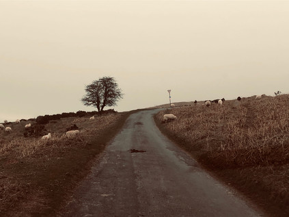
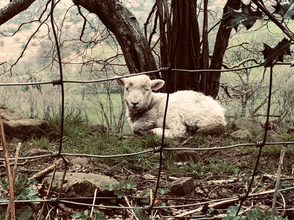
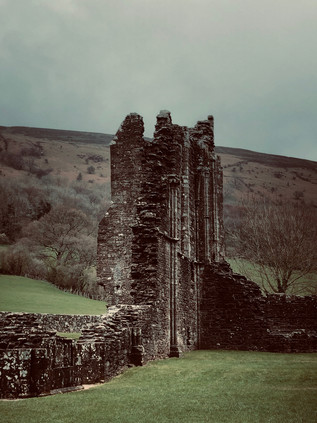
On our last morning, over an excellent breakfast, our host asked if we were going to travel home via the Gospel Pass. I knew we were close to Capel-y-Ffin and Llanthony, but hadn't hazarded a mention as I figured the drive would be very challenging on more, even narrower roads. These long-contested borderlands had featured in the confoundingly complex, dreamlike novel Landor's Tower by Iain Sinclair - and while I'd seen this as a minor distraction from his London writing at the time I first devoured it, I'd been haunted by the unseen landscapes and occult associations ever since. Surprisingly, the suggestion was eagerly accepted and after taking leave of the friendly dogs and the beautiful room we were soon heading off towards Llanigon, climbing slowly on a single track road. We saw very few other vehicles, a mist descending as we climbed towards the pass where England met Wales. The driving was exhilarating at times, the road hugging the edges of long drops into the valley below - and as we climbed we realised we we driving into a cross-country cycle race and needed to pause occasionally to let each cluster of cyclists pass unhindered. The road climbed towards the ridge and opened into a square of gravel which served as a carpark. We were surrounded by sheep, their eerie cries muffled in the foggy air. Lambs tottered along behind their mother, while groups clustered along troughs of feed. For a while it was just us and the sheep up here. The pass: Bwlch yr Efengyl, may derive its English name from one of two christian myths: that Caradog brought St. Paul through the mountains here to preach the faith to the heathen Celts, or that Crusaders passed by in the 12th Century preaching and raising funds for their expedition to the Holy Land. In either case, it has an ancient feel. The earth seemed to settle slowly when stepped on, the fog to part unwillingly to let us pass through. The sheep were unaffected, able to scamper and gambol along the mountainside at will. Humans though, were less welcome now. We pressed on, down the valley to pass the tiny church of Capel-y-Ffin - the Church of the Boundary - and to descend to the ruined priory at Llanthony. There had reputedly been a place of worship here since Dewi Sant established a cell in the 6th century. The first priory was established in 1108 via the finances of the de Lacy family and had become an important Augustinian house by the 12th century. However the priory faltered as attention turned to power struggles in the monarchy at the time of King Stephen, and the 4th Prior, William Wycombe took flight to Gloucester where he established Llanthony Secunda in the comparative safety of England. The de Lacy family once again took back the land and built the vast church which can be seen in part today, surviving despite the lawlessness and rebellion which stalked the borderlands and the rebellion of Owain Glyndŵr which threatened the Abbey's income and existence.
Llanthony continued to attract new groups of the idealistic and faithful, often with unlikely leaders. First came the troubled and hot-headed Bath born poet Walter Savage Landor, intent on improving the monastery but quickly falling into dispute with the locals who stole from him and failed to undertake the works he specified. His tendency to attack opponents in libellous verse saw him fall into further expensive and interminable conflict, and he finally left Llanthony for Jersey in 1814 at speed, reputedly having been flung from a first floor window by an unhappy local. Landor was followed by Joseph Leycester Lyne who arrived in 1869 making repeated attempts to buy the Abbey ruins from the Landors to prevent the operation of a public house in the grounds and to restore a religious order, based on his own strange take on Christianity. He finally admitted defeat and purchased 32 acres of land nearby to build a new monastery. Styling himself Father Ignatius, he established Llanthony Tertia where his eccentric collision of High Anglicanism and Celtic mysticism would ultimately fail to flourish. Diarist, clergyman and nudist Francis Kilvert observed that the guileless abbot was 'robbed blind' by tradesman he paid without a contract to finish the monastery, and Lyne fell foul of the Church authorities after publicising ghostly presences and visitations by the Virgin and reportedly being ordained as a Druid. It's perhaps easy to understand why Lyne would find this spot imbued with ancient power: the veil of modern life felt as transient as the mist here, and the idea that the old and new were entwined was strong. The Honddu valley slumbered unquiet under the dew and it was possible to imagine Lyne striding out, the hem of his robe damp, to meet figures which disappeared before he could speak with them. Nor was Lyne the last to attempt an understanding of this landscape, with sculptor and typographer Eric Gill setting up a somewhat notorious artistic community in Ignatius' unfinished monastery buildings. Gill's acolytes included the painter and modernist poet David Jones who drew on mythology and mysticism in his work, much to the cost of his reputation in the future when such things fell out of mode. Gill's reputation too has suffered from revelations about his personal life and proclivities - and there is a queasy realisation that his establishment of a commune at Capel-y-Ffin may have been as much about being away from the gaze of authority and polite society as any great artistic purpose. In both cases though, these men drew on the strange power of the little Honddu valley in their work. Gill left the valley in 1928, four years after arriving, reportedly troubled by its atmosphere, inaccessibility and great distance from London where many of his clients were located.
After exploring the ruins, we ventured into the tiny bar which still operates in the undercroft of the Prior's quarters. We were welcomed by a bluff and friendly man who spoke with the assuredness of a local, despite sporting a broad Mancunian accent. Delighting in the chance to tick Washington off the list of states he'd served visitors from, he talked a great deal about his association with the area and his return each spring to operate the pub over the busier summer months. He also talked about the range of celebrity visitors, including Jimmy Page who had called in while passing through the Ewyas Valley on route to recording commitments. The well-stocked little bar-room was accessed by precarious steps, and soon all attention focused on getting an elderly local safely to a seat nearby. We purchased a copy of the undated pamphlet by L D Fancourt which provided a brief history of Llanthony, skirting some of the more lascivious details of later occupants, and slipped away back to the car, to complete our journey. The road levelled, crossing and recrossing the busy Honddu as it rushed to join the River Monnow and eventually the Wye as it snaked towards the Severn. The arms of the valley slipped back, opening into a broad undulating plain surrounding The Skirrid or Ysgyryd Fawr, the shivering mountain which still experienced minor landslides but which was said to have partially collapsed in a lightning storm at the moment of Christ's crucifixion. Beneath it, the Skirrid Mountain Inn still did business - reputedly haunted by those hung at a local assizes which held session and dispensed justice here in an early sort of one-stop-shop arrangement, or by slain rebels from the time of Glyndŵr. Myth and mystery were never far from the surface here on the border, painted and written over and over: Jones, Gill, Eric Ravilious, John Piper and even Allen Ginsberg had passed through. With this surprising revelation my circle closed with an unexpected jolt, and I was the temperamental youth looking for Beat Poetry in the musty stacks of Hay bookshops once again.
As we climbed the silvery ramp of the Second Severn Crossing, I felt the unexpected weight of history slipping away from us. It had been wonderful to be back in Wales after a long absence thanks to its association with unwelcome appointments at the Home Office Immigration & Visa Centre. Now we could rewrite our own Welsh story, in a similar way to those who'd occupied the venerable and desolate valley through which we'd passed. It felt a little like our own pilgrim's road, and I was surprised how strongly I felt the curious pressure of time and place in the Borderlands. I scolded myself a little for letting my rationalism slip for a moment, but suspected that it was the natural rather than the supernatural which truly held sway in Ewyas. It had been a fine weekend and we'd found a special place to which we wanted to return. But the journey home had been surprising and enlightening. The valley still had more secrets to share.
You can find more pictures from the trip here. This post takes its title in part from Allen Ginsberg's poem 'Wales Visitation', you can watch him reading part of it to an unconvinced William F. Buckley Jr. below...
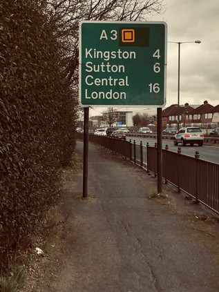
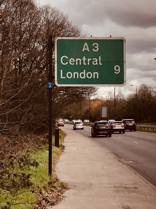
I often write about being outside my comfort zone or having transgressed the boundaries which define my normal territory. In some ways, I've made a hobby out of challenging myself in terms of range and geography, however modestly. Today was different though - I really was in uncharted territory. This wasn't nearly as dangerous as it sounds - I was in Surrey. The south-western quadrant of London is largely a closed book to me, and I confess that in part this is due to a prejudice against the leafy comfort and perceived dullness of the stockbroker belt. I've occasionally transgressed: a conference at Kingston University saw me bunked in student accommodation at Seething Wells one overheated, sweaty summer weekend in 2004, and there was, of course, my excursion to J G Ballard's home just over the border in Shepperton. Otherwise, though, I've steered clear. I knew my wanderings would bring me here one day, just as the south-east was finally opened to me by way of rivers and roads which needed to be explored. But I'd left what I saw as the meagrest pickings until last, politely pushing them around the plate with my fork in the process. But now here I was disembarking at Thames Ditton - high above a flat, green landscape of privet hedges and driveways. The ageing electric train shuddered off towards its final call at Hampton Court as I descended to the road below. I was a fair distance from where I planned to start walking the A3, partly because the road executes a sweeping curve from the south to the east here. I'd contemplated starting at Chessington and heading west to the road, but it appeared to involve trudging a network of fast-trafficked, narrow rat-runs without pavements. Here however it was calm, quiet and eerily still. Perhaps a little too quiet? I imagined curtains twitching and neighbourhood watch call-lists being activated as I shambled scruffily along the street, stopping only to snap a picture of The Wrythe - a sorry little stream trapped between driveways and suspiciously full of builders rubble. Surrey had its secrets, it seems - but today I was heading for a comparatively prominent feature on the map. I skirted the apparently affluent and rather quaint village centre, turning south towards Giggs Hill Green and the apparently slightly less exclusive Hinchley Wood. A children's football tournament was underway, and I become swiftly embroiled in a crowd of fathers offering sage advice, a hand on the shoulder as they approached the pitch. On the other side of the street, an identical stream of men commiserated muddy charges back to their Range Rovers, banging the heavy clay from expensive boots on the fender. I crossed Portsmouth Road, the former route of the A3 before it was very comprehensively bypassed. It remained a busy road through the suburbs, and I pondered the choices I'd made here. Walking the modern route of the road felt right in terms of my project, but wrong in terms of this unexplored territory. I knew the environs of the A1 and A2 well enough, and I'd accidentally covered the ground their older routes traversed on other walks - but here I had little or no prior experience and I felt unprepared. The quiet backstreet I was wandering ended suddenly at a junction with the busy Kingston Bypass which merged with the A3 a little way ahead. But my decisions were made already, and I set off eastwards, towards the major road into London.
The Kingston Bypass met the A3 in a collision of old-school suburban bypass and modern, sweeping motorway-standard road. The arms of the older road splayed and opened to accommodate the new road, sweeping in from the south and turning sharply east. In the midst of this sprawled junction, broad grassy slopes sparkling with discarded plastic litter were crossed by a footpath - if I'd headed in from Chessington and braved the nervous pathless lanes, I'd have arrived here after a walk of a similar length. The slip roads blended into the main carriageway effortlessly, amongst a landscape of scrubby pasture, abandoned market gardens and occasional flapping roadside banners advertising equestrian businesses. This was the tattered edge of Surrey - the zone where the comfort and calm of the stockbroker belt merged into the enervated edges of London. It was here where commuting city workers would feel the pressure of their collars and the weight of their burdens as they motored gracefully around the curve and over the boundary. Of all the directions I've entered London, it was the most indistinct and the least prepossessing. As the arc of the A3 tapered into a long straight, dipping under the Hook Underpass ahead, my path took the northern flank of the remains of the old Kingston Bypass, a superseded road which ran alongside its modern counterpart but didn't fully connect. Just a short leap and a metal barrier away, traffic flashed by at high speed - but beside me all was quiet. I calculated I was closing on the spot where London began and looked for signs. There were several, but none were official: a fence ran along a ditch and the roadside vegetation was replaced by a familiar sort of 1970s noise-baffling concrete barrier which graced many urban roads into the city. At the very spot where I calculated that the line was crossed a dead fox was splayed on the verge, red-furred and graceful even after an apparently swift death. The road had claimed a sacrifice already today it seemed. Looking back over the eight lanes of tarmac, a sign facing west welcomed drivers to Surrey. There was no welcome on the road ahead.
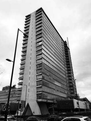
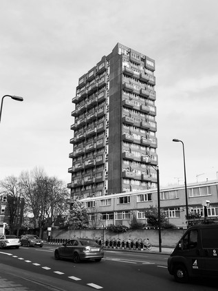
The footway ascended to cross the A243, the underpass below narrowing and slowing as the more conservative speed limits of London brought thundering suburbanites to more reasonable speeds. This was reportedly the first such grade-separated underpass in the UK, originally opening with an innovative but incredibly noisy and inefficient heating system to prevent ice formation in the depths of the cutting which delved beneath the roundabout. My path skirted the sliproad onto the A3, passing a seemingly dull branch of Topps Tiles which had a more exciting heyday. This was the Ace of Spades: a huge roadhouse sited on the A3, marking the passage into or out of London. The venue featured an 800-seat restaurant which never closed, a swimming pool, a miniature golf course and offered cabaret until 3 am. Built in the 1930s, the building was popular with early stars of stage and screen and was by contemporary accounts, the place to be seen in these parts. However, the Ace of Spades fell on harder times in the 1950s and much of the complex was consumed by a huge fire in 1955. The last remaining parts of the building are above the ground floor here - a run of mock-Tudor gables which would have fronted the road but now provide space for bright advertising graphics, glowering across the cutting at the 'Ace Pharmacy' which has appropriated the lineage. It's hard to imagine such scenes here now, in a drab car park outside a tile store. These pockets of suburban history seem unlikely and are sometimes at risk of loss to grander projects. Across the street, the Cap In Hand had closed too, its modern conservatory boarded up, marking the closure of another generously overlarge 1930s hostelry. If Wetherspoons couldn't make a stab at running a pub here, there's probably no hope for such roadside taverns on the A3 now. No-one leaves the road this early, or indeed this late. Ruminating on the idea of the 'roadhouse' and how it had all but disappeared after a final - and remarkably, still lingering - fling with Little Chef in the 1980s, I struck out for the great, grey monolith of Tolworth Tower which dominated the view ahead. By far the tallest building for miles this grey slab dominated the skyline impressively with the road leading apparently directly to its feet. It was designed and built in the International Style by Seifert and Partners, and although criticised for being an inner city building located on the fringer, it was very deliberately conceived for this suburban spot, initially housing a range of government offices and private concerns. Parking around the tower would allow efficient commuting, drawing workers away from the precincts of the City which even as Tolworth was being finished in 1964, remained an ailing post-war patchwork of bombsites and construction projects. Initially, the ground floor was occupied by the long since disappeared supermarket Fine Fare which was reputedly the largest such store in Europe at the time. Now it's a still surprisingly large Marks & Spencer Food Hall, while the northern wing of the building above operates as a Travelodge hotel. I stepped briefly into the store for supplies, emerging to skirt around the elegant concrete legs on which the tower strides to face the road. The busy run of shops on Tolworth Broadway was attracting a fair Saturday morning crowd under the shade of this incongruous interloper.
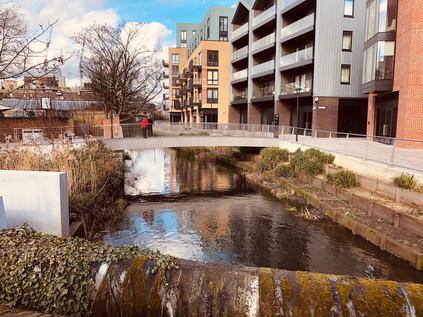
The road began a slight descent, noticeable only due to the long view ahead into a hazy morning. A thinning out of the typical mid-century villas which lined my route indicated the crossing of the Hogsmill River. Rising in Ewell and flowing north to the Thames, this was a waterway I'd yet to walk. The opportunity had never quite been right - and of course, the prejudice against this corner of London remaining strong. A flurry of greenery flanked the river as it slunk along the bottom of a shallow valley in a concrete culvert, striking out for the medieval crossing at Kingston where I'd first seen it years ago beside the Coronation Stone. The paths beside the river were invitingly cool, offering relief from the dusty sidewalks which were unenviably close to the road - but this project was now advanced enough to seem important and I managed to resist deviation from the plan. The road pulsed: alternately flowing freely and congealing into a long rope of red brake lights stretching ahead into the suburbs. The traffic beside me started to jostle for the correct lane for the junction ahead, where multiple retail opportunities converged on the road. This was Shannon Corner - so named, like many of these out-of-the-city traffic pinch points, for a former factory and local employer: Shannon Systems, supplier of office equipment. The junction was once a tangle of traffic lights and trolley bus wires, with routes to New Malden and Worcester Park conveying suburbanites back and forth across the bypass. Now it was a soaring overpass, carrying traffic over the fringes of B&Q and Halfords towards a second chance to exit for the gargantuan Tesco Extra, just in case there was something you'd forgotten on the first pass. At ground level, it was a drab and rather testing part of the walk. The morning was warming up, and the fine dry weather was throwing up the surface grime of the road as I walked. Little thought had been given to the pedestrian here: everyone arrived and departed by car with the access prioritised accordingly. I navigated the entrances to the store car parks and crossed the arms of the huge roundabout near the former Duke of Cambridge pub - now the unlikely home of a Krispy Kreme franchise. The path climbed again, the jaws of the junction reclosing on the A3 as it turned north and swung slightly to the west, taking advantage of the easy contours of the valley formed by the Beverley Brook. The road also entered a rather greener section here: the flat, fertile valley bottom was home to a string of sports venues ranging from five-a-side football to 'Jurassic Golf'. I settled into the rhythm of the walk now, enjoying the chance to stretch my legs and beginning to make a compromise with myself: this felt like a really long route, and I might not finish this walk in one excursion. Perhaps breaking my own self-imposed rules would be no bad thing though? I'd rather doggedly pursued this series of walks - sometimes against my instincts - and some recalibration might mean I didn't feel quite so compelled by the conceit I'd devised around the 'ordinals'? The road crossed the mainline railway heading for Wimbledon and I stopped briefly to watch a train passing in the now rather fine, bright morning. I also began to feel that perhaps I'd been harsher on this area than I needed to be: no doubt it differed from my usual experiences of suburban walking, but here, crossing and recrossing Brook and its culverted tributaries as I progressed north, it was hard to feel anything but pleased to be out here and intrigued by the possibilities of new routes and unexplored valleys. I mentally mapped the winding watercourses, knowing I'd want to revisit at some point when freed from the obligation of walking into the City.
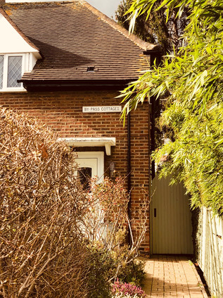
Soon, I was passing under the shadow of tall green roadsigns which signalled the end of the A3 as a proxy-motorway. The traffic streaming by began to concertina in a flurry of tail-lamps as the junction approached. A huge expanse of common land extended away to the east, but to the west, the road was hemmed in by the suburb of Kingston Vale. This uncelebrated and disconnected area of low-rise, mostly privately-built homes nestled into the elbow of the old and new roads slumbered in the late-rising luxury of a weekend morning, except for the two curved parades of shops which formed a ceremonial gateway to Grasmere Avenue where a cumbersome footbridge across the bypass touched down. The area was as much dependent on the road as it was blighted by its presence: everyone drove here, the nearest station awkwardly distant. Known for centuries as Kingston Bottom due to the slopes down to the marshy land and the Beverley Brook, development here gathered pace in the 20th century. The car made these disconnected little suburbs possible and still sustained them today. Somewhere beyond the estate, the old A3 plodded down Kingston Hill towards our confluence. Along the way it passed Holmwood the £11m gothic pile which once belonged to Rolling Stone Ronnie Wood until he decamped to Ireland with a Russian cocktail waitress, leaving his ex-wife to stage a series of revenge auctions culminating in the sale of the sprawling property with views over Richmond Park. The property, widely dubbed a 'party palace' finally sold for a full £2m under the asking price, I'm sure providing just a little satisfaction to the wronged, former Mrs Wood. A further, more noble and perhaps less contemporary artistic link to Kingston Vale lay in the clean, modern lines of Dorich House an unusual building which at first glance appears to have more in common with a mid-century factory or power station than a dwelling. In fact it combines art, industry and domicile: purpose-built by sculptor Dora Gordine in 1936, the lower floors provide lofty studios, plaster rooms and storage while a modest apartment above provided a home for her and husband Richard Hare, Earl of Listowel. Until his death in 1966 they were something of a powerhouse in the promotion of Slavonic arts and culture. Gordine, once mentioned as perhaps the finest woman sculptor of her time, began to fade from the public eye on Hare's death as tastes and fashions changed around her. In the following years, she continued to amass a collection of Russian art which is exhibited at the house today. Vacant since her death in 1991, the Grade II listed building is now in the care of Kingston University and also provides a centre for female practitioners of the arts. Set on the leafy ridge overlooking the green sweep of Richmond Park, it's perhaps not so difficult to see the attraction of Kingston Vale to artists of all kinds: not out-of-the-way but a little hard to reach. Not quite out of London, but almost in the leafy fringes of Surrey. The old road and the new finally collided at Robin Hood. Here at a remarkably poorly-planned convergence six lanes of high-speed traffic funnelled into four, with an additional local flow from Kingston piling back into the fray. The junction snarled-up and unjammed periodically, traffic pulsing rather than flowing through the complex. The origins of the name Robin Hood here are vague but like all the best tales they have been absorbed into the local fabric, providing a geographical context for dry cleaners, off licenses and car dealerships alongside the lanes and walks which have existed since Tudor times on the park's edge. It is thought that Henry VIII's fascination with the myth of Robin Hood led to the inclusion of an outlaw character in the May Games which amused court on the ancient lands of Richmond Park each year, and certainly, the name is recorded locally in the 16th century as 'Robynhood Walke'. Later, the southeastern gate of the park which I was about to pass at the end of a grubby little terrace also adopted the name, as did a local ecclesiastical parish. Names have a habit of sticking fast on the edges of London, and while the north and east have Dick Turpin as their genus loci, the south shares its unlikely hero with Sherwood Forest. Sometimes, the reverse mythology completes the circle too, with the chaotic roar of the near-present immortalised in the picturesque. As I prepared to negotiate the tangle of pedestrian crossings at Robin Hood, I noted a pair of semi-detached homes behind tall hedges and tidy gardens with a small nameplate high on the wall which honoured the mighty A3 in their name: By-pass Cottages.
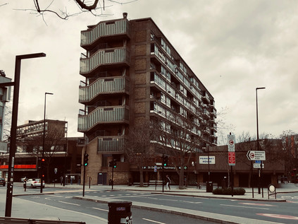
The Robin Hood Gate was set back from the road, a hint of the greenery inside the park just visible from the grey dust of the footpath, just a little way from my final crossing of the Beverley Brook. The bridge parapets would be barely visible to passing drivers, but on close examination they bore a record of an old boundary etched into their pollution-scoured stonework - to the west, Surrey County Council and to the east the former London County Council. The long slow drag up to Roehampton was still an administrative nexus, where the road marked a point where the Boroughs of Merton, Kingston and Richmond encircled a narrow outflung arm of Wandsworth just wide enough to accommodate the hill I was about to climb and the Richardson Evans Memorial Sports Grounds. It seemed fitting that Richardson Evans, colonial bureaucrat turned defender of rural beauty, should be commemorated here on the edge of the deer park - but it was also perhaps a little ironic given the total encircling of London, jeopardising many of the scenic vistas he sought to protect. A founder of the Society for Checking the Abuses in Public Advertising (or the catchier SCAPA) he supported legislation to prevent advertising in fields along the railway. In an article in the National Review in 1890 entitled 'The Age of Disfigurement' he strengthened his resolve, advocating boycott of the goods of offending advertisers and taxation of profits from such advertisements. He is celebrated at Owler Tor in the Peak District too where he did much to protect views across what later became Britain's first national park, his widow gifting a substantial tract of land in his name. The views across Richmond had changed from Evans' time for sure - not least in the form of the Alton Estate, a range of elegant tower blocks which snaked across the edge of the rising land between the Beverley Brook and the Wandle valley. Set perfectly on the falling slope of the tree-covered bluff as it turned west to break on the shores of Richmond Park, the developments were spaced thoughtfully, allowing glimpses between the buildings and to the distant Thames and City. The Alton Estate was designed by a team at the London County Council led by Rosemary Stjernstedt, and remains one of the largest developments of public housing in Europe today. Arguably, it is also one of the more architecturally and socially successful examples, and despite the usual issues of antisocial behaviour which stem more from modern estate management than design, it remains a much-loved placed to live. Divided into two distinct sections, Alton East lay before me - a range of point blocks with snakes of low-rise homes between them which peppered the wooded ridge of Roehampton. The buildings appeared to form part of their environment, there was something organic about their slender. sprouting forms. In the hazy distance, the five slab blocks of Alton West stacked towards the horizon. Largely replacing Georgian villas and their grounds, these elegant blocks are raised above the ground in the manner of Le Corbusier's machine-Ã -habiter masterplan for such developments. Elsewhere in Britain - for example at Broadwater Farm - this practice has left a dark, forbidding chasm below the blocks, ripe for exploitation by those who desire secrecy and seclusion. But here it responds to the site: the glimpses of greenery and sky tie the buildings to the ground and it remains evident why the original inhabitants of Roehampton chose to populate this ridge centuries ago. Stjernstedt and her team realised that despite all their training in the proper ways of architecture, they needed to listen to the landscape and its former stewards. When the LCC dissolved in 1965 she moved to the new borough of Lambeth working with Ted Hollamby and oversaw the equally successful Central Hill estate. There is a hackneyed and perhaps over-worked point to consider that while the great architects of brutalism who imposed their experiments on the world were largely men, it was a woman who fully realised and humanised the style in a manner which garnered popularity with those who lived within. Ted Hollamby, would touch the route of the A3 again later in the journey and a little further into the great modernist experiments in housing. While from my vantage point beside the road I could appreciate the sweep and ambition of Alton, the detail of its blend of modernism, formalism and brutalism was lost to the horizon. So it became somewhere to revisit soon, I decided. I pressed onward, the climb waking up tired legs. The walk felt vital and possible again and I strode ahead optimistically until I saw the sign...
For a moment, it seemed impossible, and perhaps even futile... Who was I kidding? This was futile, but it was my quest and only I could curtail it. I couldn't brook the imposition of failure from outside, even in truth I'd perhaps overestimated my range here. I felt like I'd been walking for miles, but the indirect geography of the A3 meant I was still miles from my goal. In its modern form this is a polite road, twisted around communities and tunnelling under areas of scientific interest and beauty. The old road was more direct, unquestioningly serving the need to link the Naval stronghold at Portsmouth with London since Tudor times. Now that I was back on the former route, things would perhaps feel more direct? Lost in contemplation of the long walk still ahead, I began the descent into the Wandle Valley and soon encountered familiar terrain as the South Circular joined my route. I recalled feeling cowed by distance on that walk too and took some comfort from knowing that I'd managed that trek well enough. As I descended into Wandsworth, the sun broke through once again and the view over the valley opened before me. I felt somewhat restored, and able to push on despite my misgivings. My descent of West Hill led me by the Royal Hospital for Neuro-disability, an internationally renowned centre for the treatment of acquired brain injury. Occupying Melrose Hall, a former private dwelling, since 1863 the facility was established under the blunt and un-euphemistic Victorian name of the 'Hospital for Incurables', and has received patronage from Dickens, Betjeman and Hardy among the usual cast of royals and philanthropists. The impressive facade of the original house glowed in the sunshine, with its sympathetically added, rather grand projecting wings standing proudly against the sluggish stop-start traffic which irritably progressed towards the centre of Wandsworth, no choice but to convene on this single, old road into town. I savoured the descent as a pedestrian: slowly emerging into the busy town centre, now mercifully emerging from months of building works which had choked the streets and masked the river from view. Now, at last, the new waterside housing blocks were complete and the view towards the Thames was once again opened up. Granted it was much sanitised, with new planting and pedestrian priority the main improvements, but it was odd not to see the sluggish brown waters lapping against the muddy banks under the shadow of the working brewery. This development had not been without challenges to retain the character of former site, but the new buildings were anodyne and artless while of course wonderfully situated, enclosing private gardens and riverside terraces. Also inevitably the new area was a 'quarter' - the perennial Estate Agent's vernacular for such reclaimed sites. The Ram Brewery's main buildings still stood - now home to '14 unique apartments' - but the distinctive warm air and tang of fermentation on the breeze was gone. Wandsworth however, appeared to go from strength to strength, the shopping centre teeming with life and the seemingly ever-present street food market wafting new aromas across the river. I lingered long enough to spy a couple from one of the blocks staring silently into the Wandle, almost trying to puzzle out why their expensive apartment had been anchored next to these ancient, muddy banks? It was time to climb out of the valley and head for town, once again passing the impressive civic buildings which housed the Borough Council, and the near-forgotten Huguenot Burial Ground at Mount Nod.
Much of my route for the next leg of the journey was familiar from walking around the South Circular. The A3 and the A205 are uncomfortable partners here, both busy routes squeezed into a gyratory which wheels around Clapham Common, spinning traffic off towards the south-western suburbs. The Common basked in the afternoon sun, the locals coaxed out to lounge or walk - one of the few things to do here which didn't seem to cost money. I noticed a trend I'd spotted countless times around the fringe of the city: young couples walking in a simulacrum of the historic promenade. Being seen out in the public green-spaces of London is an often classless but rarely costless activity, and there was evidence that a great deal had been spent on wearing just the right gear: North Face jackets zipped to the neck with a scarf against the still-biting March breezes, aviator sunglasses mirroring the traffic-lights back at passers-by. I outpaced these couples as they sauntered, largely indifferent to other passers-by and with what little I gleaned of their private conversations they appeared more focused on minor friendship squabbles, petty work dilemmas or social media indiscretions. These couples appeared to be in arrested adolescence: functioning members of society engaged in presumably valuable employment, but trapped on the very edge of adulthood, perpetually waiting for the right time to take the leap. In fairness, the rest of us were hardly helping them, and a little flurry of discarded UKIP leaflets flapping around the pavement in the breeze full of ill-informed bile reminded me that the current climate would make anyone think twice about being part of this mess. The Common remained timeless though - surrounded by grand houses which had housed generations of comfortable but radical types and flanked by streets full of fashionable eating and drinking places. Wandsworth evaporated into Lambeth, and I had a brief but misleading sense that I was nearing my goal. There was a distinct shift into Inner London here, and the squashed cathedral-like dome of Clapham Common Underground Station kicked off a long, busy High Street of nudging buses and slow traffic which seemed remote from the high-speed clamour of the A3 out in Surrey.
With the shift to inner London came a greater number of people to slalom around. While Wandsworth had prepared me somewhat for the volume of humanity, and the steady flow of pedestrians along the Common had indicated the ambling pace most of the people I now encountered would match, I hadn't been ready for the combination: a slow-moving crowd of people picking over the offer of the long strand of restaurants and bars. Clapham had varied in its fortunes over the years, moving from exclusive rural retreat to fashionable suburb, then for a while regressing into shabby, distressed city-fringe bedsit land. In the meantime it had become the byword for all that was unsurprising and reasonable - the commuter on the eponymous 'Clapham omnibus' riding the network in smug certainty of his eminent sensibleness. But now Clapham was shifting up again, and it was clear where the slow-moving promenaders I'd overtaken were heading. Being seen hereabouts was as important as being here, and wherever there was an opportunity to sit outdoors on the pavement, those who could afford it had taken it up while those who couldn't slunk by absorbing the vape clouds and reflected glory. The oldest suburban traditions held fast: if you couldn't be with the right people, be near them:
The great number of insignificant People who are by no means fit for the better sort of Conversation, and yet have an impertinent Ambition of appearing with those to whom they are not welcome.'The Spectator, No. 24 - March 1711
The bustling string of upscale establishments had a good run, but it came decisively to an end at the railway overbridge near Clapham High Street station. Overground trains rattled by reassuringly often and there was considerable foot traffic between the station and the nearby tube entrance, but otherwise, my surroundings became suddenly drab and downbeat. Almost reassuringly so, and I confess to feeling instantly better fitted to circumstances. I'd shambled in from the edge of the city, walking for sweaty and dusty miles and getting progressively less suitable for the kind of company I'd kept for the last mile or so. I was aware that I was frowning and perhaps even muttering irritably to myself as I jostled for space on the pavement among the purposeless amblers out for a stroll. I had no more right to occupy a contested sliver of sidewalk of course, possibly in many ways even less - but I'd convinced myself of a purpose and I wasn't going to be thwarted.
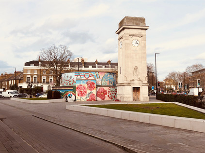
The road straightened and headed unrelentingly towards the city marking a transition into Stockwell which was gentle and surprisingly leafy. The street was lined with the kind of mid-century tenement blocks which had sprung up to resolve the first great housing crisis south of the river as slums were cleared and development edged west along the Thames. These blocks were interspersed with the kind of low-rise estate-as-community projects beloved of the Borough until they were pushed into more drastic action in the late 1950s. Tall buildings along this stretch of the A3 were relatively rare, and where they did rise over the rather traditional street frontage they were solid little point blocks, resolute and robust. The area had a sense of calm, commonplace continuity. There was a sense that important things happened elsewhere. But the cluster of statues and memorials which were grouped around the Underground Station told another story of Stockwell: one which mixed the everyday acts of wartime bravery celebrated on village greens across the country with surprising acts of uncommon heroism. The formal War Memorial is a stocky and austere stone cenotaph, sparsely embossed with delicate carvings and housing a four-faced clock. Beside it, the brick drums of the surface entrance to the deep-level tube tunnels beneath the Northern Line which served as air-raid shelters were decorated with a colourful mural depicting people and events from the history of the area. Local boy turned actor Roger Moore appeared as James Bond beside a scene depicting the arrival of the Empire Windrush which greatly diversified the life of the Borough. Beside them glowered Vincent Van Gogh who lived nearby in Hackford Road while working as a London agent for art dealers Goupil & Cie. Alongside these better-known local luminaries, however, was recorded the little-known story of Violette Szabo. Raised in France to British and French parents, Szabo returned to South London aged 11 and despite a reportedly 'boyish' athletic streak and quick wit, settled into what was typical work for women of the day in the Oxford Street branch of Woolworths, and the Le Bon Marché department store in Brixton. As part of the early war effort, she worked variously in the Women's Land Army and in munitions factories, meeting her Franco-Hungarian husband Etienne Szabo on Bastille Day in 1940. They were swiftly married as was the wartime custom, and he returned to service in the French Foreign Legion in North Africa. Around this time, Violette was recruited through unknown routes, to the Special Operations Executive, finally completing her training in January 1944. She was to make two missions into occupied France working to support Resistance networks and to disrupt Nazi efforts to quell the Normandy landings. During her second mission, she was captured, turned over to the SS and after an arduous journey east, set to hard labour in Ravensbrück Concentration Camp. Her record of dissent and non-compliance in the camp alongside her continued efforts to buoy the spirits of other prisoners and outspoken commitment to finding a means of escape finally brought a response from the highest authorities of the Third Reich which regarded resistance fighters and undercover operatives as outside the Geneva Convention. Thus, orders were given for Szabo's execution during early February 1945 and aged 23, the woman referred to by Leo Marks as 'A dark-haired slip of mischief' was shot dead. So much of her story as reported emphasises how untypical her qualities were for women of the time - but perhaps the only truly untypical thing about Szabo was her incredible behaviour.
But not all of the memorials clustered around this tiny remaining scrap of Stockwell Common harked back to the impossible horrors of war in foreign lands: some were nearer to home and chillingly closer to now. On 22nd July 2005, Brazillian electrician Jean Charles de Menezes was shot and killed at close range by undercover Metropolitan Police officers - possibly accompanied by members of the Special Forces - pursuing him in the mistaken belief that he was one of the suspects responsible for the bombings in London on 7th July. The confusion, disinformation and collusion to hide the facts of a botched operation which followed the shooting represent some of the darkest days of the Metropolitan Police, and showed an organisation in chaos following the catastrophic assault on the capital and buckling under the strain of the vast operation to track down the perpetrators who were still at large. It also exposed the shocking susceptibility of the modern news media to rumour, supposition and opinion as the chasm-like lack of an official response was filled with variant eye-witness reports, amateur detective work and plain old guesswork. While there was a strong post-incident belief that de Menezes was being smeared in an attempt to justify the extreme force used, it's far more likely that the then largely unchallenged powers of the media were simply extrapolating any rumour into an already complex web of fact, fiction and half-understood intelligence gleaned from sources of varying credibility. Today, the shrine which swiftly grew next to the news kiosk outside the station has taken a more permanent form as a mosaic designed by local artist Mary Edwards in collaboration with Jean Charles' cousin Vivian Figueiredo, and Chrysoula Vardax who had cared for the original shrine. The mural watches over the passing pedestrians on the street, walking safely in the belief that they are protected from the actions of hidden terrorists but reminding us that the very structures that protect us can turn on the innocent in times of horror and doubt. Stockwell feels inconsequential on the surface - another bit of London most of us would be hard pressed to identify, and with no clearly defined beginning or ending - but like almost every suburb it has a narrative buried in the dust of its pavements.
After the surprisingly arresting crossing of Stockwell I entered a zone far more identifiable as London. The road here surfed the boundary of Lambeth and Southwark, and marked a more significant architectural divide: low brick blocks in the London County Council tradition flanking the grand sweep of Surrey Cricket Club's ground at The Oval to the north, while high-rise towers of concrete loomed from the south. South London expanded quickly in the 19th century, building on an already established and busy street pattern of poor quality homes nearer the river, where burgeoning industries needed a supply of workers. The clearance of slums wasn't swift, and despite efforts to improve conditions between the wars, the drive to provide a sufficient quantity and quality of housing only really found its feet after 1945 when many thousands of homes were already lost. This meant that the need was urgent: a dizzying array of system-built schemes, experimental designs and one-off projects began to crop-up in the southern boroughs. Young, modern-minded architects who would struggle to find commissions in the fairly stuffy pre-war boroughs were now pressed into urgent service, their most unusual ideas fine provided the numbers stacked up. In Lambeth and Southwark this resulted in clusters of redevelopment around the areas worst affected by bombing or where slum clearance left the most gaping holes in the infrastructure. It also made for accidental grace in utility, with the sweeping concrete spans of Stockwell Bus Garage just a brief detour away from the road. The A3 now ebbed and flowed from traffic-light to traffic-light, slowly pushing traffic further into the heart of London. Alongside the road, with their roots buried in the backstreets sprouted a crop of towers apparently built from a crazy tumble of balconies stacked atop each other. In fact, balconies seemed quite the thing here. Not for Southwark were the sleek, clean lines of Le Corbusier or the cliff-like slabs which were being cranked out through Laing's Jespersen System. Ted Hollamby's Pinter, Arden and Beckett Houses protruded like off-white fangs, their irregular sided profiles casting uncanny shadows over the neighbourhood. Meanwhile, another Hollamby-led high-rise scheme at Holland Rise House included the same curious buckled fascia with waves of concrete balconies cascading down the tall tower, but in the original pebbledashed raw concrete and with a weathered exterior looked a rather grimmer proposition. Ted Hollamby led the charge towards high-rise living in Lambeth, overseeing its transition following the reorganisation of London government in 1965 and continuing to build in the unusual style seen here. Hollamby continued to work in Lambeth until 1980s when the Labour-led Borough's policies finally drove him into the private sector, largely against his socialist principles. There he worked to secure the redevelopment of the Isle of Dogs and campaigned for the building of the Docklands Light Railway. Hollamby left the role of Chief Planner and Architect of the LDDC in 1985, concerned about the direction of the second phase and particularly the Canary Wharf project. He died in 1999 at William Morris' Red House in Bexleyheath, a property he and his wife had assisted in saving from decay decades earlier. Looking ahead, the shining, modern towers of a future city at Elephant and Castle were beginning to in the shimmering sunshine of the advancing afternoon, and given his later work for the market it would have been interesting to know Ted Hollamby's thoughts on modern London and its precarious housing situation?
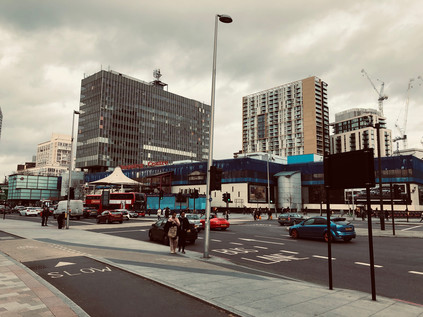
Most often referred to simply as 'The Elephant' this place, while feeling decidedly modern, has a rather more distant origin. There was an already long-established crossing of ways here by 1641 when John Flaxman built a forge to serve passing traffic. A tavern followed, and its location at the nexus of routes between Kent, the South Coast and London made it a popular place to pause but eventually a fashionable outpost in its own right. By the turn of the 20th century, both the railway and the Underground had echoed this ancient pattern and built a place of interchange at Elephant and Castle. Unlike the busy circuses of the North, this South London hub was a little more lawless and ungoverned continuing the long South Bank tradition which had seen it noted for bawdy theatres, licentiousness and bear-baiting. When the motorcar arrived, the Elephant became a whirling, impossible-to-fathom circus of routes. Local traffic vyed with long-distance routes, and the pedestrian was relegated to a supporting role in the drama of the junction. Then the war came, and it landed hard on this important spot. The historic fabric of the area was almost entirely destroyed in the Blitz leaving great need of housing, but in the eyes of reform-minded borough planners, a great opportunity too. The re-development of Elephant and Castle is not an entirely happy story, but it has achieved one of the goals of the planners: it has maintained a sense of local community. It largely did this by creating vast estates, snaking away into the suburbs which were capable of housing almost all of those displaced by the bombing. The huge concrete wall of the now demolished Heygate Estate, penetrated only via the circuitous ramps and walkways which created a haven for those who wanted to lose or become lost may have presented huge social challenges to the authorities, but it also meant that families who identified as South East Londoners remained in the city and weren't decanted to the fringes. Around the junction though, this made for a strange hotch-potch of schemes washing up against the tide of traffic, dominated by the currently part-demolished anachronism of the Shopping Centre. A modern precinct buried under residential towers, this local commercial hub had managed to remain a part of the fabric of the area despite never really attracting big name stores. Now it was part-deleted, the plastic cladding which had artificially aged the structure gone, but the period lettering proclaiming its purpose still intact above the ill-fitting pagoda entrance. Inside, I could imagine the smell of disinfectant and the creak of a fixed plastic chair in the Wimpy Bar. Around the stricken and soon to be revitalised shopping centre the ages of Elephant unravelled: the shining oxblood tiles of Leslie Green's 1906 Bakerloo Line station faced-off against the difficult-to-like fang of Strata SE1 finished in 2010, with its tapered roofline supporting three apparently non-functional wind turbines. The classical columns of the Metropolitan Tabernacle meanwhile, were offset by Metro Central Heights - formerly the Department of Health offices, when built known as Alexander Fleming House. This clean, functional set of blocks was an early London commission for Ernö Goldfinger, setting out his stall and predicting his future clustering of high- and low-rise blocks, but succumbing to a reputation for 'sick building syndrome' which saw the Civil Servants move on and eventually, a award-winning future as a residential block. Finally, the off-kilter slab of Perronet House occupied a windswept corner: designed by Sir Roger Walters to offer split level 'scissor flats' with views from both levels, this block was the focus of a movement of guerilla gardeners during the late 2000s. Centring on activist Richard Reynolds, their activities in beautifying the Elephant long predate current schemes to improve the area. And what of those schemes? The swirling roundabout of traffic has been 'peninsularised' into a freer-flowing inverted question-mark, with the A3 weaving through it and not-quite-circling the electricity substation which doubles as a monument to Michael Faraday, born nearby on Newington Butts. As I tracked the road around, grabbing my hat to stop it being swept away by the wind gusting across the expanse of featureless but tidy new public realm, I thought about my first visit to this area when attending a training course for work in around 2005. Descending from the grimly dilapidated station and hurrying by the overbearing slabs of the Heygate Estate, we scuttled into a spartan and rather eerie budget hotel for the night, emerging only to eat an overpriced Indian meal before bunkering down for an hour or so in The Rockingham Arms - a frankly terrifying local Wetherspoons pub. I hadn't realised back then that this grim bolthole, selected to delay my return to an equally unedifying hotel, was a little corner of a Goldfinger development nor that it was named for a geological feature which would come to intrigue me years later. In the bright sunshine of the afternoon which bounced off the metal and glass of new towers of unaffordable housing, it didn't seem quite as forbidding perhaps? Whether the Elephant would retain its character and identity or whether the rather curious malaise which seemed to scupper every change would prevail, remained to be seen.
Unreal City,
Under the brown fog of a winter dawn,
A crowd flowed over London Bridge, so many
I had not thought death had undone so many.
Sighs, short and infrequent, were exhaled,
And each man fixed his eyes before his feet.
T.S. Eliot - The Waste Land, 1922
Still with Eliot in mind when I touched down in the City of London at last, I turned west and headed along King William Street towards St. Mary Woolnoth. This strange, unchristian edifice had long fascinated me and had drawn me east when I still felt that this zone was beyond the pale. Much of my long walk into London along the A3 had been in areas I'd felt were similarly alien at one time: the ungoverned precincts of grubby, ancient Southwark fell first - the past just too alluring to avoid them. Then the eternally morose, forever embattled zone of Elephant and Castle with its roots in deepest prehistory. Finally, the suburban banality of edgeland Surrey - quiet and unremarkable on the surface, but with unexpected stories hidden behind its net curtains. The A3 had promised little beyond a good long walk, but it had delivered far more than I expected. Of all the roads I'd walk as part of this exercise, it was the one I'd encountered least, but may be the one I'd remember longest. As I finally took the pressure of my aching soles in a long-familiar coffee shop I'd already begun to delve into the stories twined inextricably around the oddities I'd discovered. The A3 was unexpected - a route of anomalies - architectural, geological and societal.
You can find more pictures from the walk here.
Lost::MikeGTN
I've had a home on the web for more years than I care to remember, and a few kind souls persuade me it's worth persisting with keeping it updated. This current incarnation of the site is centred around the blog posts which began back in 1999 as 'the daylog' and continued through my travels and tribulations during the following years.
I don't get out and about nearly as much these days, but I do try to record significant events and trips for posterity. You may also have arrived here by following the trail to my former music blog Songs Heard On Fast Trains. That content is preserved here too.
