It's fair to say that I've never coped well with nature. As a child of a New Town, my forays into nature weren't manifold. A tentative attempt to help my grandad in his steeply sloped Worcestershire garden usually ended up with him frustrated and me distraught, and school trips to local beauty spots were fraught with hazards both real and imagined. Wasp stings, insect bites, nettle rash - I dreaded them all and avoided them at all costs. It has been a real surprise then to find myself, in recent times at least, getting a little braver when faced with wild patches of woodland or sudden bursts of edgeland greenery. I used to avoid it, the shudder of range anxiety stopping me at the stile. Now, I'm far more likely to plunge into waist-high grasses and ankle-bothering nettle beds. I've grown up a little and realised that the countryside is no more conspiring to maim me than the often provisional and ungoverned urban zones which I quite happily wander around. During this shift, I've also become curious about what I'm walking through, or even sometimes upon. Thrashing sounds in the undergrowth still startle me, but I'm more alert now - eyes quickly darting over to see what made them. I can name some of the invasive species I inevitably walk among, and I'm no longer terrified that every tall plant is some new hybrid of Giant Hogweed which will stoop to burn and blister my fragile, town-boy skin.
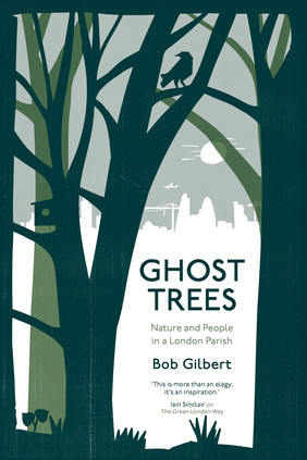
Amid this shift in my appreciation of things natural, a few fortuitous books have landed to assist - and chief among them is Bob Gilbert's account of his growing knowledge and appreciation of the flora in the East London parish of Poplar. Taking a single parish, indeed one which is not primarily known for its green spaces - just 26.6% of Tower Hamlets is 'open space' compared to Havering's mighty 59% - provides a hyperlocal focus which could potentially be restrictive and cloying - but Gilbert's melding of local history, botany and autobiography is equal parts illuminating and life-affirming. In short, it is everything good local history writing could be, but very often isn't. Gilbert's account begins with his removal to the Vicarage of All Saints, his wife's first posting as a freshly ordained Anglican minister. The undercurrent suggests that the move isn't wholly what Gilbert would have wanted - but he weathers the change and begins to explore the area, determined to become a good "vicar's wife". As he begins to unravel the sometimes turbulent history of this tiny but significant patch of London, he also documents the relationship of people, trees and place on the basis that there is a shared history. After walking every street in the parish, he sets out to find a Poplar in Poplar - uncovering a history of migration and transplantation in the natural world which echoes the human experience of the East End. A quest for Mulberries is equally enlightening: unravelling stories of class and folklore which take Gilbert on a surprising journey from the beginnings of his quest to know Poplar.
While Gilbert refers to the long English tradition of parson-naturalists throughout the book, he is decidedly not given to bouts of proselytism. During the course of the book he examines the pagan beliefs about trees and other plants which still oddly govern our attitudes to nature today, and even has a stab at dousing the course of the long since disappeared Black Ditch from the trendy city fringes to the forlorn inlet at Limehouse where it now sputters fitfully from a diversionary sewer at times of high water flow. His writing is engaging and human throughout - and even when he tosses a few of those impenetrable Linnaean binomials into the text, it's usually both necessary and enlightening. Bob knows his trees - and he knows his adopted parish too. What's harder to discern for me is how the book reads to someone less well-versed in Poplar geography. Is it necessary to be able to picture the canal ramp up to the A12 or a particular scrap of land beside Bromley Tesco from my tramping of the borough? I suspect not - but it is engaging to follow along with a map, understanding that all of this surprising diversity, fecundity and remarkable social history is crammed into such a tiny patch or urbanity.
The book ends with Gilbert resurrecting the Rogation - the beating of the Parish bounds in order to bestow a blessing on the people and their endeavours. He examines the pre-Christian origins of this ancient custom, the significance of the type of wood used for beating and the unhappy fate of those who were inverted and beaten along the way. He also persuades a good number of the flock to restage the walk with him, along the way opening a debate about public and private space within a parish which endures despite truly dramatic levels of inequality. Gilbert's gentle prose, his patient and humourous approach to complexity and his love for the topic at hand elevate what could be just another local treatise into something rather special and engaging. As I conquer my prejudices about the greenery around me when I walk in the city or its edgelands, it's just this kind of thing I find myself wanting - and perhaps needing - to read.
You can buy Ghost Trees at Amazon, or better yet at your local bookshop.
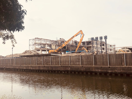
Returning to the scene is never wise, but if I was to fulfil my debt to the River Crane, it had to happen. Over a hectic summer with numerous missteps and changed plans, I'd always found somewhere else I needed to be. There was a strange hiatus too: a reaction to finally completing the London Ordinal walks. While I usually benefit from a plan, I so easily become a slave to the method I've determined. So, cast free of any real or imagined obligation I'd struggled to find the right walk, confused by options and dismayed by unchecked difficulties. During my last walk I'd had a fractious, disconnected response to the city which troubled me. Today though, I knew I was in the right place. Since I'd walked the A4, this unfinished business on the western edges of London had been gently edging into my thoughts again. So after a timely arrival in Paddington and a swift dash around the concourse, I was heading back west into the suburbs. I alighted at Hayes and Harlington: often passed through at speed, but never before visited, it felt oddly familiar and entirely alien at the same time. Outside the station, a brand new development of homes and ground-floor shops housed a small supermarket. I ducked in for water supplies, then headed for the Grand Union Canal. This too was a sliver of unwalked waterway which I knew I would need to revisit - but the brief section I found on descending to the towpath wasn't entirely unrecognisable: I'd gazed west from a previous walk, overlooking the derelict remains of the Nestlé works. Now the plant was a skeletal ruin, its white plaster walls remaining as jagged fragments of facade in a landscape of rubble. The towpath was litter-strewn and overtopped by energetic fronds of buddleia waving in the breeze. Amidst a cluster of old clothing, discarded cider bottle and the tell-tale silver pellets of N2O canisters, I turned aside and headed up the ramp.
The familiar path took me to the litter-strewn, wooded embankment of the M4, turning west and following the road briefly to an underpass. Noise is so much part of the fabric of this part of London that it almost disappears, and the constant drone of traffic above was almost a comforting vibration. The tunnel under the motorway emerged in Cranford Park, passing through the gatehouse of its stable block which had both enchanted and unsettled me on arriving unexpectedly here before. The rather forlorn, abandoned building still had the power of surprise, and emerging into the open, green spaces of the park was equally jarring after the straggling urban clutter of the first miles of my walk. I lingered a little longer around both the remains of the once-great house and the tiny church of St. Dunstan and the Holy Angels with its Templar and Hospitaller associations. The road to the church was busy with volunteers and visitors, a strange young man - well-dressed and agitated - pacing around the headstones in the churchyard, crossing and recrossing my path as I ambled among the memorials. Here in this little-visited but hardly quiet spot near the M4 lies Tony Hancock, the embodiment of the tragic comedian. A little before my time, his work overshadowed my own early discoveries and seemed tame and compromised as I delved into Monty Python. But as I've grown older I've found myself appreciating the pathos in his despairing looks to camera as the situation unravels around his character. In truth, Hancock's frequent sidelong glances are often his resort to a teleprompter having suffered memory problems after a car accident, but there seems a haunted look about him. As he wrote in the note left on his suicide in Sydney: "things just seemed to go wrong too many times". It's a simple, pathetic observation we could probably all make - but here in Cranford, he was at peace at last. Nearby was a character who sounded no less tragic, but was far more mysterious: John Finall Cook, described in his own epitaph as "the worst used High Constable in England". Despite leaving quite a trail, there is little to tell quite what ill-use cook suffered. Aside from a case of 'burglariously breaking and entering' heard at the Old Bailey - the defendants found not guilty - his career as the High Constable of Isleworth does not seem to have been worthy of much remark. He lived to the respectable age of 85, and in his 70th year prepared a book of bible selections - Sacred extracts, or, The Beauties of the Psalms and the Apocrypha. In 1845, Cook petitioned the House of Lords to pass a bill rewarding High Constables for 'meritorious services'. Given the reputation of Hounslow Heath as a dangerous and forbidding wilderness, it's perhaps possible to imagine Cook run ragged by a rural crimewave during his career. If that was the case, little evidence of it survives and the curious wording of his gravestone remains a mystery.
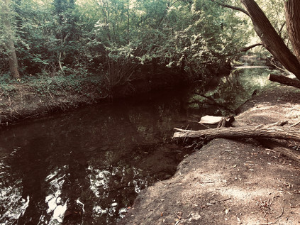
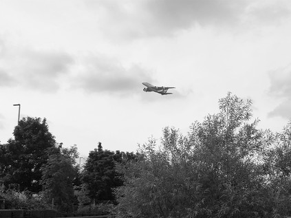
The path followed the bank of the river southwards, shadowing The Parkway for some distance, and I felt somewhat foolish for having abandoned this more pleasant passage for the tarmac on my last visit. Crossing the river into Avenue Park, I met a clutch of friendly dog-walkers tramping across the unmown tinder-dry grass rather than edging around the field. I followed suit, abandoning the river for a stretch, as I needed to head for an exit onto the Great West Road. The distant line of hotels and offices strewn along the Heathrow fringe shuddered in a heat haze while planes wheeled overhead after their steep ascent, insignia clearly readable in the glint of sunlight. It felt like a good morning to be walking, even the glowering owner of a trophy-dog greeting me with a smile and a nod as I passed out of the park and into the urban hinterland of Cranford. I needed to walk the pavement a little here to regain the river, crossing the A4 at a point I remembered well from my recent linear walk. The road shimmered in the heat, still unexpectedly quiet considering its importance, and I was swiftly across and diving into a cul-de-sac of semi-detached homes which had been slotted into the irregularly shaped parcel of land next to the river. The sun-baked concrete roads were dusty and reflected the heat back at me. A huge black four-wheel-drive car with dark glazed windows snaked into a space at the roadside, the rear door opening to admit two elegantly dressed young Indian women heading for a function, before speeding off around the loop and back towards the main road. Between the houses, at the end of the close, I found the unmarked pathway into the park and allotments which petered out into rough heathland on the edge of the river. Once into the park, I struck out to the west getting as close to the water as I could. The river flowed quick and clear through the narrow wooded strip which shadowed its passage between the eastern perimeter of Heathrow and the Cranebank complex, home of British Airways' training centre amongst a sprawl of disused and apparently abandoned buildings from an earlier phase in the development of the Airport. Heathrow dominated the zone: tall lights towered over the treeline, and a vast hangar was visible between the trunks of ancient riparian oaks. Every few seconds, the air was rent by the searing jet engine sound of take-off or the reverberating howl of resistance as a descending airliner fought its purpose to stay aloft. At such close quarters, the noise was like nothing I'd experienced before: for a few seconds, my hearing was overwhelmed to the point of shutting down. It was not, as commonly thought, a roar: it was a tearing apart, a sundering of air. The view of the underside of the passing jets allowed me to pick out tiny details, like turning over a model plane for inspection. Living here must, of course, afford one some sort of immunity to the constant sound - and it's possible that, like passing trains, it could become an almost soothing clue to the normality of life continuing outside. But here, under the flight path, I wondered how human beings could adapt to such hostile audiological conditions?
The path emerged from the trees, depositing me unexpectedly onto Earhart Way. This was part of the Heathrow estate and I was immediately aware of the scrutiny of CCTV around me. The road layout had altered here, access now being from the eastern end of the industrial park, meaning that traffic avoided entering via the airport's well-guarded gates. An abandoned checkpoint to the west was blocked with concrete barriers and signs signifying there was no passage for pedestrians. Interestingly, waymarks for the London Loop path also pointed west, defying the otherwise omnipresent authority of the airport. Despite the neverending pulse of aircraft movements, my walk had felt largely separate from humanity and its machinations since leaving The Parkway behind, but now I was faced with multiple layers of human activity presenting barriers to my onward passage: ahead of me, the Piccadilly Line extension sloped out of its tunnel to pass over the Crane - the cost and complexity of remaining in tunnel beneath the water table too great. Beyond the concrete retaining walls of the railway, the Great South West Road blocked my path, cars flashing by as they accelerated towards London. This corner was not always a nexus of busy routes: Dockwell Lane had once cut a lonely path across the northern reaches of Hounslow Heath, fording the River Crane at this spot. It was in fact the perfect place for Heston and Isleworth Urban District Council to site Dockwell Isloaton Hospital which opened in the early 1890s. In 1895 a scandal arose regarding the poor conditions at the hospital and it was resolved to build a new, modern facility at Mogden which opened in 1898. From this time onwards, the Dockwell site was vacated, opening only infrequently when epidemics overwhelmed the new hospital. Staff would be seconded to reopen the somewhat outdated and increasingly dismal wards for tiny groups of Smallpox and Diptheria patients during the 1920s and 30s, with the site finally closing entirely in 1935. No trace remains of the hospital, with much of the site being absorbed by Cranebank. It seemed odd to imagine the next generation of pilots using complex simulators to learn their craft on the site of this gloomy and forsaken institution. I turned west, navigating the barriers and heading along the airport perimeter road for a short stretch before joining the footpath along the A30 and immediately feeling more secure. The vast hangar building which had appeared fitfully along the river path was now in full view - impossibly proportioned but still dwarfed by the huge areas given over to staff parking on the eastern edge of Heathrow. Empty shuttle-buses rattled by, heading for hotels and terminals, while Underground trains clattered along beside me in their concrete gully. This part of the route had seemed unnececssarily complicated when I was planning to walk along the Crane - there would surely be some other means of crossing the road without the long doubling-back to Hatton Cross, but sure enough, the unbroken streams of traffic were unrelenting. I finally made my crossing at the site of the almost entirely deleted hamlet of Hatton, the sleek blue glass lozenge of the new Atrium Hotel now taking up almost the entire footprint of the former village, the established pattern of roads which had once encircled it relegated to the status of a gyratory. Nestled into the corner of the junction, near a farmhouse decked-out in 'Help for Heroes' banners and repurposed as an X-ray freight scanning business, horses grazed lazily in the sunshine. I was now directly under the path of departing planes on the southern runway, feeling their tumult rather than hearing it now. The horses munched on, unconcerned by the cacophony above. I set out to retrace my steps towards the river, and the opportunity to disappear into the woods once again.
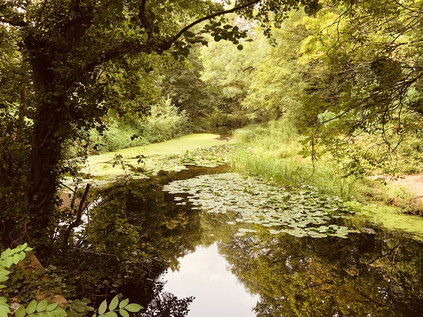
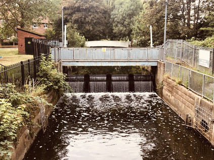
The section of the river south of the Great South West Road wound along a damp and boggy plain, dominated by the huge balancing reservoirs which managed the water running off the airport site and preventing the escape of kerosene and de-icing agent into the Crane. The path clung close to the river, raised on a walkway above the marshy ground. Aside from the regular interruption by aircraft, the path was quiet with only the babble of water and the scrabbling of unseen creatures surprised by my passing. Relaxing into my surroundings, I realised how tense the passing of Heathrow had left me feeling. The river occupied a narrow strip of scrub and woodland between large industrial and distribution parks which clung to the edges of the airport. This industrial encroachment wasn't new however, and the banks of the Crane here had always served a purpose: despite the relatively poor flow of water there had been a succession of mills along the river. As early as 1630, Benjamin Stone's sword manufactuory had finished weaponry imported from Germany, stamping it 'MI FECT HVNSLOE'. Contracted initially to supply the army of Charles I at the nearby barracks, the King's flight from London left him near bankrupt. But the business was momentarily secured by the raising of a public subscription to purchase swords for Cromwell's parliamentary army. Thus Hounslow-made blades may have been the downfall of combatants of both sides of the conflict in the English Civil War. The water meadows here, while naturally marshy, were made more so by a complex of mill leets dug between the Crane and the man-made cut of the Duke of Northumberland's river, a canal constructed possibly as early as 1530 to augment the waters of the Crane with flow from the Colne abstracted at Longford. This waterway, much re-routed and reconstructed at various points by the expansion of Heathrow finally found its outflow amongst the boggy copse of Donkey Wood, where I crossed the head of a broad green pool before finding the spot where the water tumbled down a weir into the river. This confluence of man-made and natural rivers lay a little north of ancient Baber Bridge where I once again crashed out of the woods and into civilisation, however briefly. There had been a crossing of the Staines Road here for time immemorial, and certainly, since a wooden structure was first recorded in the 13th century, then known as Beaver Bridge. The current crossing, distinctly broad considering its great age and built of a purplish-grey brick, dates from 1798 and is the work of the County of Middlesex. This route was part of the Devil's Highway - an impressively durable and direct route from London to Silchester and eventually to Aquæ Sulis which survived as an important highway long after the Roman occupation of Britain. The origin of the name was regarded as 'fanciful' by Lt. Col P L Macdougall who gave an inaugural address to the Surrey Historical Society on the matter of the route in 1854. While parts of the route into London are still debated, the celebrated antiquarian William Stukeley rode out of London to Staines with some confidence he was tracing the correct path. General William Roy also uncovered part of the route himself when undertaking his pioneering measurement across Hounslow Heath in advance of a triangulation of the whole of the isles of Great Britain which he wouldn't live to see completed. Today, Baber Bridge was busy with traffic battling roadworks and congestion, drivers barely noticing their passage over the Crane as they navigated what seemed to them I'm sure to be nothing more than a clump of unusally dense woodland. I chose my moment and crossed the venerable road to the west, finding the continuation of my path a little hidden in the entrance to a busy Jet filling station which added all the usual conveniences to its offer. I resisted the promise of Costa Express and passed through a cluster of seemingly disused vehicles and over a gate into Brazil Mill Wood. Within easy reach of Hounslow Barracks, use of the various mills along the Crane often turned to martial duties, with numerous former grain and dye mills turning to the manufacture of gunpowder. With the vast Hounslow and Bedfont mills already engaged in this hazardous task, this made the banks of the Crane a somewhat risky place, prone to frequent fire and explosion. In 1752 the mill situated in the woods here shifted to the more pacific pursuit of creating a distinctive red dye from paubrasilia, and leaving this narrow strip of surviving woodland its current name.
Below Baber Bridge, the Crane splits into two streams and skirts the western edge of the remnants of Hounslow Heath. This wide plain of both wooded and coarsely grassed wild land was once much larger, and not a place to linger on the roads west of London. It was the isolation which provided an opportunity for military assembly on the heath and the lawless reputation of the place which likely required the army retain a presence here in the longer term. Cromwell stationed his troops here in 1647 as the Civil War came to a close, with James II subsequently exercising troops here to intimidate Londoners into accepting his position. A permanent barracks at Hounslow was founded in 1793 in fear of an impending French invasion, with troops regularly performing cavalry exercises on the Heath until the First World War. Urbanisation gradually encroached on the Heath from the 18th century, in part due to the presence of the barracks and then the coming of the railway which crossed the Heath on route to Waterloo. Though much smaller as a result of this gradual erosion by the city, the Heath today still has a desolate and lonely aspect, and I felt surrounded by the sense of loss and excision which appears to haunt the valley of the Crane throughout its length. The path meandered with the westernmost stream of the crane, buried in unruly trees and largely separated from the broader expanse of open land which was briefly London Terminal Aerodrome until Croydon took its place in 1920. South of the tracks, a large part of the Heath was purchased by the London & South Western Railway in 1914 to form its huge Feltham Marshalling Yard. With the outdated facilities at Nine Elms overwhelmed by new traffic and losing profitability as early as the turn of the century, the LSWR had decided to construct a new yard to aid in combining joint traffic with other railway companies more efficiently. Impressed by the 'hump yard' principle in use in the massive stockyards opening in the United States, Sir Herbert Walker, General Manager of the company persuaded directors to purchase additional land to the east in order put these innovations into practice. The shaping of the yard involved diverting the Crane and the Millstream and excavating huge amounts of earth. Around 200 German prisoners of war assisted in the effort, and the first sidings were opened in 1917. The yard was a technological marvel in its time: using the hump shunting system, track circuits for signalling and electronic control from a central 'tower' which allowed gravity and switching gear to sort an incoming train in as little as twelve minutes.
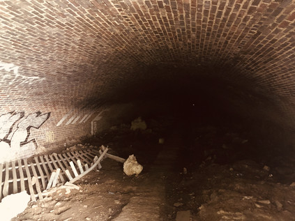
Approaching the much-reduced railway lines today, the path meandered into an open field before stopping abruptly at a graffiti-daubed wall with trains clattering by just feet above me. The river plunged into a dark tunnel with a ripe, sewer-tainted atmosphere, and a cursory inspection indicated two issues: firstly, the tunnel was much longer than I expected, and secondly, there was no walking route beside the waterway. Near the tunnel-mouth was a metal gate across a second portal, drawn back just far enough to give access to a broad brick arch. It didn't look welcoming, but it offered the only hope of a route onwards. I entered, encouraged by a faint glow of light which seemed not far ahead, but was plunged almost immediately into deceptive darkness. The curved brick soffit stretched into the distance, soon disappearing from view. A prick of light seemed impossibly tiny and far away, the debris-littered floor visible for only a few feet ahead. This couldn't really be the path onward could it? I tried not to lose my cool: I was in the environs of a city which hadn't managed to daunt me yet - but this might finally be enough. Latent claustrophobia which I could usually suppress crept over me as I edged forward towards the slim patch of light I'd seen. Somehow I found my nerve and pushed on towards it, moving as fast as the treacherous ground would allow. Cut into the tunnel's western wall, an equally narrow doorway allowed enough light to identify it as the source of the glow. A tiny, rutted path rose out of the gloom. I gladly took it, following the confusing route as it doubled back onto the top of the tunnel I'd just escaped from. I was disoriented by my brief time underground and felt disinclined to wait here. The whole zone seemed deserted, even the people looking out of the frequently passing commuter trains seemed to look right through me into the distance. Who would expect to see anyone out here after all? I stumbled south along one of the barely discernable paths, much relieved to be outdoors. A mixture of haste, relief and I'm ashamed to say a little post-adventure bravado led to some poor route choices here. The paths over the tunnel were unofficial and somewhat provisional in nature. Little more than desire lines in places, sometimes giving out altogether at an overgrown tree or deep copse of tall bushes. I faced some confounding choices but aimed roughly south, using the noise of the railway behind me as a guide. At what would turn out to be a crucial juncture, I took the wrong fork, crashing through shoulder-high nettles and brambles to descend onto an initially welcome, if filth-strewn tarmac path which skirted the edge of the Jubilee Mail Centre. The path was littered with fly-tipped obstacles and overhung by thick branches which whipped at my face. It reeked of human filth from the lorry drivers which parked up outside the warehouses ranged around the mail hub and apparently regarded it as a public convenience. At the end of the path, I found myself in a cul-de-sac - the only way out was a circuitous navigation of the industrial park which would deliver me some way off my route. There had to be another way. Recalling the point where I'd decided that the unofficial path looked more likely than the gap in a high palisade fence, I decided to retrace my steps. I almost never do this - it feels so unintuitive in most cases, but I needed to find the Crane again to reorient myself and not feel like I'd been defeated by my foolish phobias. I crashed back into the bushes, finding the route much harder going when I was fighting gravity to get back onto the crest of the tunnel. I was rewarded with a surprising sight I'd missed on my descent: in the rough gorse beside my path was a stretch of long-abandoned railway track.
Beyond the fence and with my unplanned and falteringly fearful Cavalry Tunnel experience behind me, the deep green gloom of Pevensey Nature Reserve was almost welcome despite the humid and still air under the trees. I followed the main path, noting that I should be able to take a fork to the east which led back to the riverbank, passing a range of apple trees planted by the community. The ground was littered with early windfalls and the air buzzing with bees and insects as I followed an indirect route back to the bank of the river, still flowing swift and clear despite its long journey under the old Marshalling Yards. This wild and long-abandoned patch of former farmland formed a narrow municipal dividing zone between the sprawling edges of Hounslow and Feltham. Hidden in the scrubby trees was a series of circular concrete bases which once contained the collected effluvia of the district, and nearby the South Middlesex Crematorium still performed its ever-necessary function among the woods. The paths closest to the river in the most recently annexed part of the reserve were informal - officially still "subject to consultation" - which made for a quiet and pleasant section of the walk somewhat insulated from the surprisingly nearby suburbia, and screened from activity in the better-used Leitrim Park. It was a rude shock to be deposited onto the Hounslow Road via a narrow gap in an old railing. The road bridges over the twin streams of the Crane presented a dividing line here: to the west was the Borough of Hounslow, and to the east Richmond. The river had been a dividing line for time immemorial, and it now split these relatively modern jurisdictions neatly along a largely undeveloped strand of formerly industrial riverine parkland. Crane Park is shared by the boroughs, a mile-long oasis of green in the otherwise uniform suburbs which nestle in the arms of the Hounslow Road and the Great Chertsey Road. Once across the street and inside the park I found a seat in the neat outdoor classroom area and rested for a while. Having failed to plan this walk, I'd been guilty of a little complacency too - I'd walked rivers before, and thought I knew what to expect, but this had thrown me some very unexpected experiences which I needed to consider before pressing on. I watched a community of dog-walkers assemble, exchange news and disperse while I snacked on oranges and gulped water.
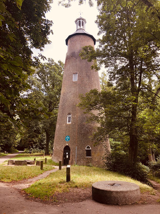
The day was getting warmer and stickier, the riparian air still and humid. It was time to press on into the busy park, cyclists buzzing my elbow and joggers huffing by. The river split into multiple streams, pools and reservoirs here which had served to control the flow of water through the Hounslow Gunpowder Mills which once straddled the banks here. The site was ideal for a mill, with a ready supply of willow and alder for charcoal, navigable access for barges and sufficient water to drive the wheels. Initially a corn mill, consent for the manufacture of gunpowder was given in 1768 though it seems likely that this hazardous production had begun unlicensed on the site prior to the Earl of Northumberland's permission. Explosions at the mills were frequent, with loss-of-life almost mundanely common. A particularly devastating event in January 1798 claimed four lives, with further accidents in July of the same year claiming three more. This pattern continued into the next century, and in 1859 Abraham Slade, Somerset-born builder and diarist recorded that: 'On the 29 of March the Powder Mills blew up, sending seven poor souls into eternity in a moment. It has broken a great deal of glass in Twickenham & neighbourhood.' Gunpowder was produced at the mills until 1927, and following closure the site was almost entirely cleared of structures given the hazardous nature of its business. Among the remaining blast mounds and sluices in the mill streams, the only remaining building is the much restored Shot Tower, believed for many years to have been used for the manufacture of lead ammunition, but more recently considered likely to be a windmill. Upon closure, the former Gunpowder Mill site was purchased by a local councillor with a view to selling it as a going concern but with this proving an unlikely outcome, he sold the land to the Borough of Twickenham which opened the area as Crane Park in 1935, with the Shot Tower becoming a small museum and visitor centre in more recent times. The island in the divided stream of the river has, since 1990 been a local nature reserve and was busy today with families looking out for wildlife in the ponds and surrounding woodland. As I continued through the busy park I reflected how the nature of my route had changed in such a short time. The fearful, lonely crossing of the Heath seemed far away now.
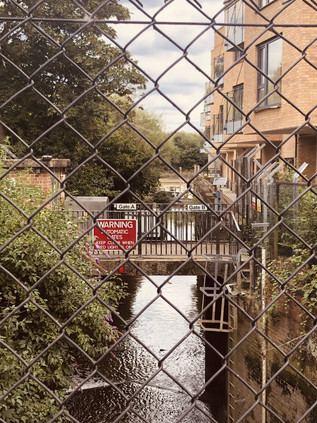
The river passed under Meadway by way of a handome concrete ballustraded bridge, providing something of an ornamental entrance to Kneller Gardens. Named for Sir Godfrey Kneller, the remarkably prolific court painter to monarchs from Charles I to George I who produced society portraits on a near-industrial basis. Kneller is reported to often have worked with other painters in form of production line, each undertaking the part of the portrait in which they were specifically skilled: faces, fabrics, animal companions and suchlike. Kneller set up home in nearby Whitton in 1709 in a mansion reputedly designed by Sir Christopher Wren. His home was in turn largely demolished and replaced in 1850 by Kneller Hall. Lately the building has been occupied by the Royal Military School of Music, and served for a time during the Second World War as the HQ of the Commander-in-chief of the Home Forces, The MOD has longstanding plans to close the site in 2020, when it seems likely to fall into use as high-end residences in common with many of the fine old houses of South Middlesex. The more modest park named for the portraitist was home today to well-attended summer holiday events, the café busy with relaxing cyclists, and the shady riverside paths thronged with strollers. I presented a pretty fearsome sight I'm sure now, thudding along in heavy boots, sweaty and ruddy from a long slog along the river. All around me I was concious of the conspicuous health and affluence. The first leg of this walk had begun in the comfortable suburbia of Harrow, and I was now, many miles of intangible no-mans-land later, finally entering a similar zone. At the eastern corner of the pleasant little park I faced a decision: here the Crane split again from the Duke of Northumberland's River which turned north passing Twickenham's brace of Rugby stadiums and heading through the midst of Mogden Sewage Works, much beloved of Nick Papadimitriou, Seer of Middlesex and veteran urban perambulator. The junction was marked by a tumbling weir and a sluice. The 16th century artificial channel turning north and passing under the railway was walkable, and my earlier researches told me that the final stretches of the River Crane - now in an albeit in a more modern man-made channel of its own - were most assuredly not. But whether from loyalty to this persistent little river, or because I found myself once again enslaved to my methodology, I took the path along the Crane. The Kingfisher Bridge was a recent development, linking Kneller Gardens to the Mereway Nature Park since 2010. This scrap of green space bounded by the railway line and the river was originally marshland, but once drained provided a site suitably far from civilisation to build a sewage works and a small isolation hospital. A few surviving hospital buildings were marooned in the midst of sparkling new wheelie-bins and redundant roadsigns in Richmond's Central Depot. The idea of this tiny island in the midst of dense surburbia being considered remote felt unlikely now, and as I paced along the fence of the Depot, dodging prams and cyclists who were skirting the edge of Craneford Way Playing Fields, I noticed the butts of Twickenham Rifle Club across the concrete channel of the Crane - another facility which would have originally benefited from the isolation of the site. This last truly walkable stretch of the Crane was bounded by a tiny sliver of recently re-opened land known as Twickenham Junction Rough. A decent surface had been laid alongside the river as it skirted the broad loop of railway which swooped across the mainline bringing the line from Strawberry Hill to Twickenham Station. The isolated land had been acquired by the developer of the former Royal Mail site beside the river and opened to create an apparently already well-used local link. The river was sluggish in its channel now, somewhat narrower than its natural flow further upstream, but surprisingly still free from litter and running clear despite the built-up surroundings. The land here had once been known as Marsh Farm and was in the ownership of the Pouparts family. This line of notable market gardeners were of Hugenot descent with Samuel Poupart first setting up gardens in Battersea, where the family name remains in Pouparts Junction on the West London Line. His nephew WIlliam began growing apples, cherries, lettuce and cauliflower at Marsh Farm from around 1882 and his son began trading at Covent Garden market around 1892. The company continued to trade in the New Covent Garden site into the 1990s, close to Samuel's original Battersea lands, and the company remains extant as the marque of a specialist fruit importer.
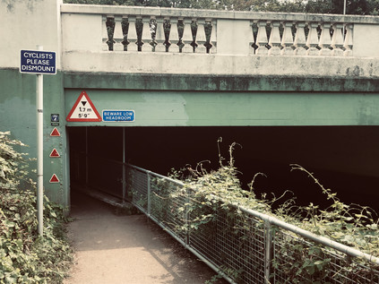
The railway swooped in to land beside the mainline while the path hugged the bank of the river. The land in between was now known as Brewery Wharf - a textbook mixed-use development. At the front, near the station it was a modern range of commuter-friendly studio flats with café opportunities and retail units, while the island of land between river and rail was given to ranks of faux-victorian blocks in yellow London brick, like some sort of simulacrum of a Peabody Estate. Despite the outward appearance of period industrial dwellings, this was of course a luxury development which featured a range of four-bedroom townhouses marketed at somewhere around the £2m mark. It represented a pretty good return on a narrow and unpromising plot which had once been part of the grounds of Heatham House. This tidy but extensive house still stands near the bridge over the Crane, having been built at some point in the 18th century on what were previously recorded as apple and pear orchards. The origins of the house aren't noted, but it was likely built for Stephen Cole, who lived here until his death in 1790. The house remained on the increasingly busy junction at the edge of Twickenham's centre, passing through the hands of the statesman Roger Wilbraham, the actor-manager Sir Charles Hawtrey and to its final public owner William Thomas Lane who sold his independent fisheries business to Unilever owned MacFisheries. The house was purchased by Middlesex County Council in 1944 and after local lobbying was sold again to the Borough who began providing youth services in the house from 1950 which continue today. The Cole family brewery was extant on maps of the area in 1635 and expanded into the management of local public houses throughout the following centuries. By the 1890s though, the company's debt was mounting, and George Cole sold the brewery to Brandons of Putney. Looking for wise investments to further clear the family debt and noting the growth of the commuter suburbs along the railway, he ploughed the proceeds from the sale into developing a new estate on the familiy's land near Heatham House. The first homes were occupied in 1898, and by 1902 a bridge over the Crane had been erected to link with newly provided recreation grounds. After a hazardous crossing of London Road I ventured into this legacy via Cole Park Road, still a leafy, quiet street of victorian villas today. The afternoon was close and humid, a churn of gloomy clouds progressing across the otherwise blue skies. Under the suburban trees, life seemed easy and remote from the uncanny tensions of the airport zone where I'd begun walking. I slipped into an alleyway between driveways which housed fine, expensive motor cars, and crossed Moor Mead Bridge into the recreation grounds which Cole had thoughtfully provided his residents. Despite being somewhat marooned by the railway line, the green spaces were busy with families - the children's play area particularly so, making sticking close to the edge of the river a risky business. A lone walker appearing from the treeline is never a welcome sight to risk-averse parents raised in the era of stranger danger and steeped in recent lurid exposé. I skirted the playground carefully, heading for the exit into the quaint, flower-bedecked cottages of Brook Road which were an unlikely introduction to the chaos and fumes of the Chertsey Road. I took a last glimpse of the River Crane as it disappeared under the road to resurface in an inaccessible strip of allotments. Turning east towards the Thames, I headed for St. Margarets Roundabout avoiding a rusting and inhospitable looking footbridge over the busy route which was, nonetheless subject of a campaign to retain and restore it by concerned parents.
I knew little of this part of London - St. Margaret's had been little more than a wake-up call on the rail journey into Waterloo: you're almost there, gather your wits and your belongings. The surrounding environs, seemingly inert and rather tamely dull, had also found infamy as the unlikely stalking ground of the Bus Stop Murderer, finally unmasked as the repellant Levi Bellfield who has still yet to admit to the extent of his actions. The walk along what was ostensibly its main thoroughfare did little initially to budge the sense of banality and inconsequence. But this area was once a zone of exclusive and fashionable riverfront properties, and some survived - not least Gordon House. Originally known as Thistleworth House, it was purchased by General Humphrey Bland, author of A Treatise of Military Discipline, who demolished the older property in favour of a newly built mansion, one of the earliest designs by Robert Adam. In 1868 it passed to Francis Jack Needham, 2nd Earl of Kilmorey who modernised the house and incorporated his capital-K family insignia throughout the buildings. He also moved an elaborate egyptian-style mausoleum to his mistress and ward, Priscilla Anne Hoste into the grounds. Kilmorey had outraged Victorian society in 1844 by eloping with his ward, and fathering a son to whom he gave his name. Despite this scandal, and in a surprising nod to propriety, he housed his family in a property separate to his own home but constructed a tunnel between his home and theirs. Hoste died of heart disease in 1854 and the distraught Earl spent a remarkable £30,000 on the mausoleum by Henry Edward Kendall Jr. in pink and grey granite, bronze and marble. Devastated by Priscilla's early demise and unwilling to be separated from her, The Earl moved the mausoleum several times at considerable cost before settling on a location in the grounds of his much-rebuilt Gordon House. Here too he constructed a tunnel, linking the mausoleum to the house. He is said to have then initiated the mawkish practice of often dressing himself in a shroud and lying on a trolley to have his household practice his last journey to accompany Priscilla in her final resting place. The tunnel fell into local legend after the passing of the Earl and the site became a Teacher Training college, latterly part of Brunel University, but excavations in the 1960s during the construction of modern college buildings in the grounds revealed the tunnel, tiled and decorated with slopes at each end. Somewhere in my walk along these final stretches of the Crane I had passed over the Earl's subterranean via dolorosa. A little north of the end of the snaking brick wall which once enclosed the grounds of Gordon House but now screened a range of luxuriously appointed infill developments from the road, I crossed the river for the last time. Through a chainlink fence, I could see its last narrow stretch emptying into the turgid muddy Thames near the southern tip of Isleworth Ait. A modern apartment block hemmed in the river, the confluence hidden behind lazily repetitive red brick stacks and a private waterfront. This reduced and constrained channel felt an inauspicious and anonymous ending to a river which had flowed swift and broad further upstream, and which had endured the interference and industry of mankind largely without injury over the centuries. I turned aside to complete the last stretch of my walk, feeling uncharacteristically deflated.
As soon as I could, I found my way onto the bank of the Thames. At times like this, it felt like a surefooted way to regain a sense of the walk I'd just completed. Instead, I found myself navigating the primped and managed edge of Berkeley Homes' Fitzroy Gate development. The White House, built in 1832 by Pugin & Pugin, gleamed across the private lawn enclosed by crescents of new-build townhouses apparently - but somewhat inexplicably - constructed on the principles of ancient Chinese geomancy. I glanced back along the river, but the inconspicuous mouth of the Crane couldn't be seen. I headed north, along the riverfront terrace of the Town Wharf public house, which felt like an unwanted intrusion on the afternoon of the patrons, and towards a large metal crane which stood inert on the riverbank. This totem marked a second confluence - with the Duke of Northumberland's river. This shadow of the Crane had crossed my path at Colnbrook when I walked the A4, joined the Crane in the clammy midst of Donkey Wood and left it again to detour through Mogden's massive sewage works. Now it too met an unremarked end not far from the Crane. I walked it back to the main road, though the pretty, rural edges of Syon Park. This apparently idyllic reach of the Thames concealed a deceptively brutal history: the embarkation point of both Catherine Howard and Lady Jane Grey on their last journey to the Tower of London. My last view of the river as it curved to the east was of the medieval ragstone tower of All Saints Church amid the trees and watermeadows. The Crane had revealed an older Middlesex: the market garden which supplied the growing city, but which was finally swallowed entirely by London. I circled the turgid millpond and followed the ancient line of Mill Plat along the edge of almshouses built in 1664. All seemed quiet as it likely had for centuries beside this stream.
As I made my way back to Syon Lane station, remarkably close to the factories and progress of the Golden Mile where I'd found myself just a few months ago, I reflected on the journey I'd finally completed. The initial walk which began alongside the Yeading Brook had seemed unlikely to yield any great revelations - but the prim net curtains from Ruislip to Isleworth had twitched to reveal surprising histories: unsolved murders in the upper reaches and the stalking ground of a serial killer nearer the Thames. The unsettling isolation I'd felt in the wilder stretches of the nascent Crane in Ickenham and Northolt was repeated in the heightened tensions of Heathrow and the oppressive crossing of the wetlands around Cranford. The Crane was not a lost river - spending perhaps more time above ground than any of the Thames' western tributaries rising in London - but it was unremarked and often uncared for. In some ways, this left it free of some of the indignity wrought on its sister streams. With its heydey as an industrial power long faded, and its situation in the hinterlands of the airport making it largely unattractive for waterfront development, it still flowed swift and true though woodland, heath and park. Following the dissolution of Middlesex, the river's function and status as an administrative boundary often ensured that no single authority could decide to divert, pollute or enclose it. The Crane was a truly suburban entity: going about its mundane business largely without fuss or recognition, its roaring days behind it and only a quiet and undistinguished ending to look forward to. While Betjeman lauded his 'gentle Brent' it was hard to imagine him eulogizing the Crane - this story of the banal suburban propiety, suppressed dark histories, and compromised futures would be more suited to Philip Larkin's darker territory if anyone's. Perhaps J.G Ballard had encapsulated the surprising persistence of the river best:
Prosperous suburbia was one of the end-states of history. Once achieved, only plague, flood, or nuclear war could threaten its grip.The Crane lacked a patron poet of any great stature, but as I clambered onto the eastbound train and headed back towards the City I felt like I'd done it some sort of service in finally completing my walk of its route as I'd set out to.J. G. Ballard - Millennium People, 2003
You can find more pictures from the walk here.
Lost::MikeGTN
I've had a home on the web for more years than I care to remember, and a few kind souls persuade me it's worth persisting with keeping it updated. This current incarnation of the site is centred around the blog posts which began back in 1999 as 'the daylog' and continued through my travels and tribulations during the following years.
I don't get out and about nearly as much these days, but I do try to record significant events and trips for posterity. You may also have arrived here by following the trail to my former music blog Songs Heard On Fast Trains. That content is preserved here too.
