Here on this Middlesex Turf: The Yeading Brook
Posted in London on Saturday 11th August 2018 at 8:08pm
I'm fairly often asked 'Why London?' when I speak about my wandering. Living in the West Country, a comfortable distance from the zone of poor air quality that sheaths the city is, to most, a huge positive and the question appears to assume a deficiency. Why not walk the countryside and the beaches on my doorstep? In truth, the origin of the walks I take can be traced to a very specific event in my life which thanks to the internet I can date fairly exactly - a purchase one gloomy November evening in 2002 of 'The Lost Rivers of London' by Nicholas Barton. I'd felt my interests converging before then of course: a fascination with London in literature had seen me gradually explore eastward from the comfort-zone of arrival at Paddington, and an equally abiding interest in railways had seen me exploring the subterranean byways of the city too. As I began to delve into the curious valley of the Fleet and its history, Barton's book was recommended. It opened a new door: the idea that the history of London was hidden in plain sight, never far from the surface and detectable in the lie of the land and the curves of the streets. Of course, not all rivers are 'lost' in the sense Barton suggests. Some have not been buried, culverted or stopped up, but have simply drifted out of the everyday experience of most Londoners. They slip forgotten between backstreets, appear briefly beyond anonymous railings, then disappear again around an inaccessible corner, or beneath a railway line. When I realised I could find these not-quite-lost rivers with a map, a bit of research and a decent pair of boots it started a habit of walking which persists to this day.
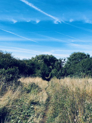
So, it was because of that fateful purchase I found myself heading west today. It felt a little counterintuitive, having spent a rare night on the eastern edge of the City, to be heading this way - but I'd had little time to plan for this weekend and was determined to do something which would take advantage of a more relaxed schedule. After an unexpected dash across the platform at Baker Street, the Metropolitan Line deposited me at North Harrow, a station I'd passed through but never alighted at. I knew very little of this area, indeed I suspected I'd only ever set foot in the Borough once before, even then only just passing over the border to spend a fitful night in a Premier Inn before a rail excursion. On that occasion I hadn't even detected the shift into Harrow - it just felt like the suburban strips I'd seen from passing trains: post office, hairdresser, modern flats filling in the gaps between the classic North London shopping parade and the massive new supermarket. At first sight, the station at North Harrow appeared to represent the boundary between the little town centre, mostly clustered along the nearby crossroads with the A404 and sleepy suburbia. This wasn't the Harrow of the public school and quaint hilltop village which harked back to Betjeman. North Harrow was the sea of rooftops which his 'rocky island' looked out upon. It was still relatively early, and few people stirred as I headed out of the station and doubled back into Northumberland Road. Here and there, people were leashing dogs for their morning walk or loading the car with luggage for a holiday. It was already remarkably warm out here and I felt privileged to be out walking rather than stuck in traffic on a Motorway today. A little way along the street I spied a low metal railing on each side which indicated the spot where the Yeading Brook passed under the road, and where my walk would begin in earnest. This modest but surprisingly long stream falls definitely into the 'mislaid river' category. Flowing almost entirely above ground and through some remarkably accessible open land, the brook is largely ignored. It rises a short way to the northeast of my starting point, near Headstone Manor - and while I could have begun walking somewhat closer to the source, a fairly substantial stretch of this first part of the waterway is inaccessible. A visit to the moated manor house and Museum of Harrow would have to wait this time. Instead, I turned west on a path which snaked alongside the brook, through pleasant if somewhat parched and tired looking greenery. The first part of my walk would be typified by these spaces: valued local segments of parkland which were left over from the suburban sprawl which had created these places. These were the awkward corners, easily flooded valleys and scrappy boundary lands where another house couldn't quite be squeezed in. Some of them had been adopted and transformed into more formal linear parks - and it was one of these which marked my first encounter with the Yeading Brook. Busy and fast-moving despite the dry conditions, it was reasonably clean and free of algae too. I nodded to passing dog-walkers, papers tucked under their arms as they headed home or off to breakfast, and let my legs find their stride. It felt good to be walking.
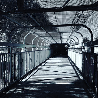
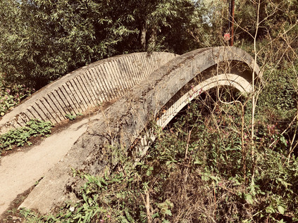
The brief parkland path soon deposited me near a five-armed roundabout, where I was forced back onto pavements for a while, striding out along the sleepy Church Lane which returned me to the brook at the entrance to the Streamside Open Space. This was a pleasant and quiet, though altogether wilder park which ran for a short distance along the Yeading Brook, again taking advantage of the strips of useless land which fringed the waterway. I was temporarily enclosed by trees and walking a scrappy trackway which reminded me of my recent forest walks. All too soon it was over, and this patch of reclaimed territory in the midst of Metroland gave way to another suburban street and the impassible barrier of the Metropolitan and Piccadilly Line branch to Uxbridge. I suddenly felt very far away from London in a sense which I've generally only experienced in the furthest eastern reaches. The mild thrill of feeling almost-lost in new territory spurred me on, and I headed along the street to find the bridge at Cannon Lane. Here the road occupied the entire width of the original bridge and pedestrians were filtered off onto a footbridge which paralleled the road - a fortified tunnel of spikes and wire cladding which purposefully spanned the tracks. Rejoining the lane, I descended at the first possible opportunity into Roxbourne Park and crossed it to find the brook at its eastern edge. The park is oddly named, given that the Yeading Brook runs alongside its entire length while the Roxbourne, one of the Yeading's tributaries which emanates from the same high ground, runs some way to the south of the park. I crossed the brook, eschewing a more formal tarmac path and disappeared into another run of fairly wild, wooded territory which ran along the eastern bank. It was gloriously tricky going here, the path winding between trees and sometimes appearing to give up entirely before unexpectedly switching direction back towards the water. A rather makeshift looking brick bridge crossed a currently dry stream branching to the south, while I picked my way through earthbound loops of tough branch and piles of windswept fly-tipping. Over the brook, the rather tamer environs of the park tapered into some playing fields, and my path soon opened onto a wide grassy field too, well-kept but largely abandoned. I crossed the brook again and walked its western bank through the remainder of the Roxbourne Park. This section was reclaimed from a landfill site in the 1970s and was just the spot for the Harrow & Wembley Society of Model Engineers to relocate their operations. The society is comparatively venerable and an early comer to the operation of outdoor miniature railways, having begun in 1937. By 1973, having experienced difficulties at their home at the British Railways Sports Association site at Headstone Lane they were looking for a site where a ground level track would let them haul passengers. The Roxbourne Railway is still operating in the park today - a kidney-shaped loop of track embedded in the sun-bleached grass, and a fan of concrete where elevated tracks facilitate the unloading of the tiny works of engineering magic which haul children and surprising numbers of self-conscious adult men. The track was silent today, the station closed for business until Sunday afternoon when trains would again process around the park.
I exited Roxbourne Park by a creaking gate with notices imploring me to close it carefully behind me. The path continued rather provisionally on the western side of Field End Road, disappearing between metal railings into a tangle of bushes. For a while it was just me and the Yeading Brook, the track sticking close to the tree-shaded water as it wound westwards towards Ruislip. I saw few other humans on this section of path, despite it providing a sensibly direct route through the densely packed inter-war estates of Ruislip Manor - something that very few other footpaths or streets managed as they meandered into crescents and dead-ends. All around me were avenues and cul-de-sacs of good, solid semi-detached homes. There were driveways where cars crouched in the heat, their bodywork reflecting intense beams of sunlight through the foliage, and there were endless faded English flags proudly hung for the World Cup and absent-mindedly abandoned when the nation's gaze once again turned inward. My path was a channel of green through all of this, opening out into the wide plain of Mount Pleasant Park. The grass was cropped tightly here, revealing a crumbling concrete road serving the garages behind homes in Torcross Road. I stomped along the rough path, realising I needed to find water pretty soon and deciding on a detour along Victoria Road to a large, modern complex featuring a supermarket, cinema and other amenities.
Little did I realise the notoriety of the apparently sleepy zone into which I was stepping. I was alerted first by a recent crime - the stabbing of Osman Shidane in May 2018, apparently by a 16-year-old boy who was subsequently arrested and charged. While I rested briefly and idly scrolled through the various sad and horrifying reports of this crime - which appeared altogether unexpected in this generally unremarkable part of London - I realised that this was not the first crime to take place on almost the same spot. On 14th September 1954, Jean Townsend was walking home from South Ruislip station having taken the last train home from a social gathering in the West End. She was last seen walking alone on Victoria Road, her body discovered on waste ground near Angus Drive the following morning, Jean having apparently been strangled with her own scarf. Despite the removal of her underwear, there appeared to be no theft, assault or sexual motive for the crime, and the Coroner expressed perplexity about why Jean had been targeted at all. In the following months the Police discovered few leads. Much was made of the presence of US servicemen at nearby South Ruislip Air Station and a report that a voice with an American accent was heard prior to a scream on the night of the murder, but this lead amounted to nothing. Rumours of uncooperative US authorities compounded the circulating view that an airman was responsible but that it was all being hushed up, and further reports surfaced of women being approached by sinister men with Amercian voices or driving unfamiliar 'American type' cars. Parallels were drawn too with killings in West Germany where bodies had been left beside the Autobahn near the bases where US and British troops were stationed. The Metropolitan Police took this seriously enough to make contact with their German counterparts, but the line of enquiry soon petered out. This may have remained an isolated and tragic suburban murder story had further events not occurred nearby: three weeks later Doris Vennell was pursued home from North Harrow station and grabbed by a man with 'a large forehead'. In the struggle, she tore buttons from her attacker's coat - but again, no conclusions could be drawn. Concern grew locally, with voluntary patrols walking women home from Underground stations in the evening, and a general unease growing around the servicemen stationed in the area. As time passed, the case faded sadly into the background of everyday life as these personal tragedies often do. Then, on 30th April 1957 Muriel Maitland, a young mother of two children failed to turn up for work. The alarm was raised and her body was soon discovered in Cranford Woods close to Heathrow Airport, a little further downstream on the course of the Brook. The assault on Muriel was far more savage - she had been raped and punched repeatedly - but no clues to the identity of her attacker were found. Her bicycle and coat were later found near the Grand Union Canal, but her murder remains unsolved. The Police briefly considered a link with the murder of June Townsend, but swiftly discounted this possibility given the different characteristics of the assault. Again, the suburbs returned to their uneasy sleep. Ruislip was by now the butt of jokes about mundanity: Neasden, Surbiton, Ruislip - the playbook of the TV comic. Everyone had heard of them, but no-one aside from their residents knew these places well enough to challenge the assertion that they were dull, unremarkable and bound to an era of the Empire and the King.
Ruislip awoke from its conservative, suburban repose with a violent jolt on 13th June 1971, when the body of 29-year-old Gloria Booth was found naked and mutilated in Stonefield Park, a short distance to the south of Victoria Road. It seems likely that she was snatched from a bus stop and taken to a nearby lock-up by her killer who tortured and mutilated her, though again did not sexually assault her. At her inquest the Coroner noted that the crime had 'unusual features' and 'aspects of a disturbing nature' which would not be revealed until an arrest was made. No-one has ever been arrested and the true horror of the crime remained, perhaps mercifully, sealed in police files. However, this unexplained pattern of attacks - likely unrelated, but curiously site-specific, hugging the course of the Yeading Brook and the River Crane into which it flows - continued to agonise the families affected. In 1982 the Metropolitan Police re-examined the files on Jean Townsend's murder after a number of anonymous telephone calls. The content of the calls was never divulged but it appeared to satisfy officers that no USAF servicemen had been involved, and also convinced them that the crime was not linked to others. Later, a schoolfriend of Jean lodged a Freedom of Information request to open the files, but was denied access. The case was heard at an Information Tribunal in 2007 which upheld the decision not to disclose the papers, sealing them until 2031. During the hearing, a detective informed the panel that while there was no imminent opportunity that the murderer might be identified, such a possibility could not be discounted. Evidence from the crime scene had been re-tested by the Forensic Service in the 1990s in the hope that advancing DNA technology might provide further clues, but this had not produced any leads. In a somewhat stranger twist, the tribunal allowed a theory to be advanced which had developed via a segment on John Peel's otherwise rather gentle Saturday morning 'Home Truths' show on Radio 4: that an Italian-English noble named Count Francesco 'Frank' Carlodalatri had taken to the habit of travelling the Central Line late at night, staring intently at people, and had indicated that he would pay a sum of money to someone 'to kill a woman'. An interview with Frank's landlady who had been warned against him but still drove him to Dover en route to Italy, never to return, suggested he may have been the attacker. In the ensuing years, the embers of these murders have occasionally been stoked by journalists who, desperate for copy, walk again what they have dubbed 'Ruislip's Murder Mile'. This invariably attributes the murders to established Serial Killers who can be linked to the area, however tenuously. Independent researchers believe they can locate Scottish murder Peter Manuel in South Ruislip in 1954, but the dates are vague and his presence largely unproven. Gloria Booth's relatives have also pressed for new consideration of her case, believing that the killing can be linked to Peter Sutcliffe who regularly visited his future wife Sonia in Alperton during her teacher training. Again, newspapers have been quick to capitalise on their search for answers but invariably turn the article over to a lurid re-cataloguing of the Yorkshire Ripper's depraved exploits.
As I retraced my steps towards Victoria Road, my bag full of water supplies for the walk ahead, I saw the area a little differently. Ruislip was as quiet as ever, its suburban character inviolate - but like all suburbs, there was the hint of Ballardian frisson here. The twitching closed of net curtains could hide a great deal, and the streets which hedged around the narrow valley of the Yeading Brook hid dark secrets. Ruislip is no different to many suburbs of London which, in the century or so in which the city has sprawled out of control, have inherited the tribulations which smaller cities confine to their central zones. But a crime out here creates deeper, if highly localised, ripples in the pond. Areas are left unwalked through fear or superstition, and stay that way as urgent news becomes a sad history and then much-distorted legend. Modern media treats all outrage equally, and they'll interview the nearest person prepared to say "You just don't expect it here, do you?" - when perhaps here is exactly where we should expect it? On almost the same spot as Jean Townsend was found 34 years earlier, a young man was brutally killed in 2018. Ruislip felt forlorn and far less inert than it had seemed when I emerged from Roxbourne Park just a short while earlier.
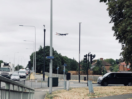
I crossed a windswept and deserted playing field to emerge near Ruislip Gardens station, crossing the busy street at a point directly above the Yeading Brook which emerged from under the railway and disappeared into a wooded gully beside the high-security fences and CCTV cameras which surrounded RAF Northolt. This base has a long and distinguished history, having opened on 3rd May 1915 as RFC Military School Ruislip, initially flying sorties to protect London from Zeppelin raids. By the end of the First World War, daring early missions over France were being flown from the base. During World War II, Northolt hosted Squadrons of Hawker Hurricanes crewed by both RAF and Polish Air Force pilots, with distinguished records established by both forces. During the Battle of Britain, thirty Northolt based pilots were killed - ten of whom were Polish and thus their national War Memorial stands nearby. The base became a target for the Luftwaffe and a plan to camouflage it took advantage of its suburban location. A stream was painted onto the runway, and the hangars and administrative blocks were decorated to appear like the suburban housing which surrounded the site. So convincing was the disguise that pilots directed to land at Northolt for the first time would struggle to find the runway. In peacetime, following the development of Heathrow Airport nearby, the opposite problem became a bigger issue as pilots mistook Northolt's runway for that of the major civilian airport on a number of occasions. Indeed, as the military role of the RAF base has declined there have been suggestions that it could operate as a satellite of the Airport, but these have come to nothing. Partly perhaps, because despite benefitting from the anonymity and uniformity of the suburbs, the Base has not always been a good neighbour. The first incident occurred in December 1946 when Douglas Dakota, G-AGZA operated by Railway Air Services took off following heavy snow and failed to gain height. The aircraft came down squarely on the roof of 46 Angus Drive, with the unharmed aircrew climbing through the loft and leaving via the front door. The house was uninhabited at the time, a couple waiting to be married before moving in soon after. In 1960 the engines of an Avro Anson failed on take-off, the plane limping over the railway line and descending onto the Express Dairies depot, now the site of the supermarket I'd visited earlier. Various safety improvements were made over the years as the drawbacks of the suburban site became clear - not least over-run pits following a 1996 incident where a Spanish Learjet crashed into a van travelling along the A40 Western Avenue while flying an actress to work at Pinewood Studios. Lisa Hogan, the passenger on the flight, who told investigators that the Spanish pilots couldn't understand English Air Traffic Controllers and bickered physically prior to the incident, considers herself to have had a lucky escape. She is however, now the long-term girlfriend of Jeremy Clarkson.
The base is quiet now, home to a range of support and storage functions, but an active runway is still maintained. In recent years this has been a place of reluctant return: the remains of the Princess of Wales were repatriated from Paris in 1997 via Northolt, the Queen's Colour Squadron ceremonially meeting the flight. Short years later, the fugitive Great Train Robber Ronnie Biggs, by then gravely ill, returned to Northolt to an equally formal welcome, being immediately arrested and returned to jail in Belmarsh Prison. He had been a tabloid presence throughout my 1970s childhood: a mahogany tan and coils of gold chain grinning amiably but smugly from the front pages as he basked in his Mediterranean exile and notoriety. But on an overcast May morning, 35 years after he escaped from Wandsworth Prison he was helped, frail and ashen-faced from the aircraft into a waiting Police vehicle. A magistrate heard his case swiftly and committed him to Prison again - essentially requiring him to complete the thirty-year sentence of which he had served just fifteen months. As I edged around the perimeter of the airfield, these notorious inbound flights seemed distant from its current purpose. Vast prefabricated sheds stored archived documents or housed the administrative staff who kept the RAF running behind the scenes. During the London Olympics, Eurofighter Typhoons had been based here, the first fighter aircraft at Northolt since the Second World War, poised to take to the air should the Games be threatened by terrorism. Even now, with the Olympics a distant memory, security was tight: an RAF Police truck appeared to track me around the edge of the site - but I was confidently on publicly accessible ground here, the path well-used by joggers and dog walkers too - at least until I reached the edge of the Ruislip Gardens estate where the path passed between metal barriers and into the unknown.
This large area of empty scrubland on the map had troubled me. It was unclear if there were paths across it, and the presence of the RAF base felt much more sinister when beyond its perimeter fence was, well - nothing much at all! This was one of those strange spots where London gives up. The last house turned inward towards the city for safety, and the cul-de-sac ended near a scrubby path into the grass. After a morning spent passing along a narrow green channel through seemingly endless suburbia, it felt both exciting and worrying to be heading into wilder terrain. The jogger who had passed me a few minutes earlier returned, his circuit complete. I was perturbed by this: if he'd circled back on his daily run, perhaps there was no way out of here after all. Was I walking into a cul-de-sac of my own? Undeterred, I snapped a picture of the back gate of RAF Northolt, obstructing a rural lane that didn't even trouble the official map and defended by cameras and dire warnings against trespass. I pressed onward into the marshy scrub on the western edge of London. The tree-lined brook skirted the security fence. There was little evidence the path was used well at all, and it often became almost impassably overgrown. I waded through shoulder-deep brambles and nettles at some points, realising I had little option but to press on, arms above my head. I felt utterly remote from the city at this point, a feeling compounded once I passed a low wooden gate into Ickenham Marsh. This clearing of wetland grasses, tumps of stubborn brush and venerable trees is ancient common land, and cattle still graze there today in a nature reserve. Given my abiding discomfort around cows, this was a problem as two huge examples of the species lurked lazily near the fence beside the path I aimed to head for. I tried to outsmart them by heading across the marsh, stumbling and tripping over the clumps of tough, reedy grass and making myself far more conspicuous than if I'd simply walked across their lazy, apparently unconcerned eye-line. It didn't work - the route took me to the edge of the fence but I'd need to walk even closer to what I now suspected were in fact bulls to get out. I retraced my steps and decided to brave the direct route. Sweating with horror and with a white-knuckle grip on the straps of my rucksack, I strode purposefully forward. The cattle, inert in the midday heat and barely inclined to move an inch, completely ignored me. I ran the final few steps through the gate, emerging triumphantly on the Hillingdon Trail, a route which would shadow the brook for much of the remainder of my walk. I felt like I'd completed some sort of trial and began walking again with renewed zeal.
The Hillingdon Trail boats a 20-mile route through some fine woodland and countryside, but my first experience of it was a rather gloomy underpass which took me beneath the A40. The path and the brook met in a concrete culvert which dipped under the bank on which traffic flashed by. The walls of the passage had been decorated in a yellow and green tiled motif sometime presumably in the late 1970s. It felt tired and abandoned down here - if it wasn't busy with walkers in high summer, when did people ever use this trail? The path turned and twisted to pass under another road - the A437 - which leaves the A40 here at a very strangely arranged junction serving Hillingdon. After surfacing, a brief walk alongside this road deposited me in a suburban park where dogs were being exercised. I paused to eat oranges and reapply sunblock before surveying the route onwards. I had foolishly assumed I'd be able to walk the Yeading Brook and then much of the River Crane today, but I hadn't reckoned on the day being quite so hot or some of the walk feeling quite so challenging. A little rested I set off again, following the signs for the trail around the back of an abandoned changing block beside the football pitches and into a narrow, litter-strewn gully at the rear of a crescent of homes. The path emerged into a broad green field which led to the entrance of Gutteridge Wood, and I was soon back on the bank of the Brook, a much broader and more impressive waterway now than the one I'd first spied in North Harrow. The woodland here was surprisingly tidy and free of litter, its decent paths accessible and well-walked. I occasionally found myself catching up with an older gent, striding along with walking poles and steadfastly ignoring my polite 'good morning' as he relentelessly pressed on, determined to tick off another designated footpath no doubt. I took a more leisurely amble through the woods, realising I was now due south of the Airfield having walked a huge loop out to the west. My path was sandwiched between the Brook and a man-made Feeder channel which carried water from the River Pinn towards the Grand Union Canal via a convoluted zig-zag of ninety-degree turns. The path twisted south, then east towards Ten Acre Wood running along the edge of a farm with tall, swaying wheat stalks basking in the sunshine. I spotted the elderly but intrepid walker heading through a gap in the hedge and striking out along the edge of the field rather than tackling the sometimes bramble-choked official path. I stuck to my route, enjoying the challenge and battering my way gleefully through the obstacles. The hum and shudder of the A40 was close by, the rumble of aircraft approaching Heathrow overhead - I was in my favourite terrain, where urban and rural meet in an uneasy boundary-strip. At the corner where a series of stiles took the path southwards, I gained a companion - an eager but overheated German Shepherd which seemed happy to join me, tongue lolling in the heat. I was sure I'd shake him off at the stiles, but he ingeniously found a way of squeezing over, under or through each of them. I paused - unsure how to proceed: I wasn't particularly confident with dogs, and couldn't figure how I'd prevent him following me wherever I headed. Eventually I heard the exasperated cries of his owner approaching. He looked at me expectantly, to see if we were going to continue our adventure. I waited. Finally he decided that I wasn't going anywhere interesting and bounded off to find his owner. I turned south, back into the woods - noting as I left the edge of the farm that the pole-toting walker was scratching his head in the corner of a nearby field which had no obvious exit onto the footpath. I was keen to get back to the Brook which the path had parted from a little further north where the Roxbourne finally joined it at an inaccessible confluence. The path emerged on Charville Lane, a road to nowhere - besides a car breakers' yard and a clay shooting club - which was littered with the evidence of late-night use. A couple of cars passed at speed, clearly not expecting to meet pedestrians and kicking up clouds of dust. Immediately opposite the path I emerged from was Golden Bridge, an impressive arc of textured concrete opened in 1986. There has however been a crossing of the Yeading Brook here since around 1500. The modern bridge was opened by Lord Bernard Miles, only the second British actor to be elevated to the Peerage and a man of Middlesex who had taken part in an early 'right to roam' demonstration near the site in 1929. Such protests soon multiplied, and a later 'mass trespass' at Kinder Scout which saw several arrests for 'Riotous Assembly' led in part to the creation of National Parks in 1949, and finally to the Countryside and Rights of Way Act 2000 which finally gave clarity on public access to open land. I passed over the bridge before realising that I was heading in entirely the wrong direction - perhaps no bad thing as the path ahead was in poor repair and seemed impassible. Instead, I doubled back along Charville Lane, finding a poorly marked turning to the south where the Hillingdon Trail, now accompanied by a local route called The Dog Rose Ramble plunged back into the trees.
I stumbled out onto the pavement near AFC Hayes football ground, the path a mess of fly-tipped junk and rutted dry earth. The Brook passed under the road via a bridge with a satisfyingly solid, municipal concrete parapet of dubious ownership: one side of the Brook claimed to be Hillingdon, while the other welcomed me to Ealing. As ever, these often ignored waterways are boundary zones - and while they exercise apparently little effect on the locals, they might well be deciding how much Council Tax is levied, or on what day the recycling truck arrives. I took the Ealing bank now, a broadening and well mown strip of grassland which shimmered in the heat. I had sore feet and I was tiring, but I couldn't quite figure how to process this walk yet - so I continued through the grass which was, at least, easier on my feet than the rutted woodland floor or the hard pavement had felt. This part of the walk was comfortably uneventful - planes climbed or descended into my eyeline, while blackberry pickers stalked the hedges beside the brook and dogs scampered across the grass. Ealing was hot and sleepy, the locals who were foolish enough to brave the sun seemed to be moving slowly, cowed by the intense heat. I schlepped onwards, deftly avoiding a careering young trainee cyclist who was being coached by her big sister and proud father, and skirting a communion of dog owners who held court in Belmore Playing Fields while their charges play-fought and panted around them. Eventually, the path reached Yeading Lane where cars were lining up to disgorge the beautifully-dressed participants and guests for an Indian wedding at the nearby banqueting facility. An impatient driver grew tired of waiting for the merry parade to cross the street, spun his wheels and tried to overtake the queue of cars while yelling a racist epithet - only to find a further huge crowd of friends and relatives crossing the street and blocking his way. He was forced to bask in the glow of his own impatience for a while as they politely shuffled by, ignoring his rudeness. The path continued into less well-kept parkland which still hugged both the Brook and the borough boundary, before passing under the Hayes Bypass. This surprisingly major road was finally built in 1991, providing a long-mooted link between the M4 and the A40 and decanting traffic away from the Motorway at the point where it loses two lanes and becomes a sluggish, urban expressway delivering traffic from Heathrow into the centre of London. Thus, the A312 has become a congested thoroughfare in its own right. The Yeading Brook effectively divides around it, one arm swinging south in culvert and channels beside the embankment of the modern road, while an older alignment continues under the road, heading east towards the Grand Union Canal. I misread the map here and pressed on beyond the bypass, following the Hillingdon Trail waymarks and into a confusing tangle of paths around the scrappy wedge of parkland beyond the road. Eventually, I found a way out, climbing the steps of a filthy, waste-clogged footbridge over the canal and descending onto the towpath. The Brook was now some way to the west of my path and hemmed in between the backs of houses. Since the canal used its valley here, it felt sensible to proceed along the towpath for now. It would have been a quiet walk too, had it not been for a couple on bicycles who had attached speakers to their machinery and passed me blasting out 1970s disco classics. Uncertain of their route, they stopped frequently meaning I would pass them while they argued over whether they should have left the path, before they would cycle on, catching me up and impatiently trying to pass me to the strains of 'Stayin' Alive' peppered with furiously rung bells. Finally the argument was won by one of the pair and they left the path. I walked on in silence, passing under Southall Road near the mock-lighthouse at the entrance to Shurgard's storage facility.
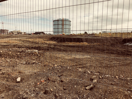
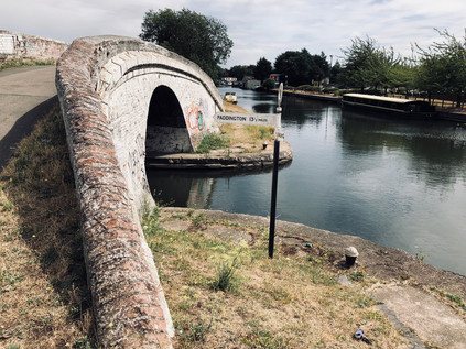
The Yeading Brook closes in on the canal here as they both turn to the southwest to pass under the Great Western Railway. This wasn't a picturesque stretch of waterway in any sense. To the east, a large triangle of land was being remediated prior to re-development, and the dry dusty contaminated earth was blustering around the site as tarpaulins flapped listless free of their moorings. The makeshift metal fence narrowed the towpath making an already rough and fairly treacherous path even trickier to navigate. As the railway approached, signalled by the regular thud and clatter of trains in the near distance, I experienced the sudden shock of recognition: I had passed this way on the train countless times and the expanse of empty land I could see was, until recently a vast carpark offering cheap stays for Heathrow passengers. At the eastern end of the site the familiar shape of the tall, pale blue Gasholder No.5 still stood. It had, for years, been a signal that London was near. I'd used it as mental punctuation - time to close the book, take out the headphones and pack my bag. Now the cars were gone, and the area was finally being redeveloped after a six-year-long wrangle with the planning process. 3750 new homes would occupy the triangle of land hemmed in by railway and canal - formerly Southall Gasworks. The remediation would be a challenge: the Brentford Gas Company had expanded west to this site in 1869 having outgrown their original plant. In the following century they had installed plants to manufacture creosote, road tar and ammonium sulphate, slowly taking over former chemical plants and brickworks nearby. As North Sea Gas became available, the plant entered a decline, broken by a brief stint as a set for a Space Refuelling station in "The Ambassadors of Death" a Pertwee-era Dr Who episode filmed in 1970. In 1973 gas production ceased, while gas storage continued in three of the five huge gasholders. Now just one remained - the iconic blue monster beside the railway - while all around it the earth was relieved of a century of pollution. The air reeked of chemical filth and I gladly pressed on under the railway towards Bull's Bridge. At the narrow, hump-backed bridge ahead, the towpath of the mainline of the Grand Union Canal crossed the junction between the Paddington Arm and the route to Birmingham. I'd read often about this spot, but it always seemed impossibly far west and out of my usual zones. The canal narrowed to the width of a boat to pass under the whitewashed bridge which arched steeply over it. A couple of cyclists paused at the peak to survey the route ahead. Beneath a sign pointed north to Paddington, east to Brentford and west to Braunston. I felt impossibly far from everywhere I knew, despite being in eerily familiar surroundings from frequent trips by rail through the area. A little way along the canal, the bulk of the abandoned Nestlé plant appeared to tremble in the heat haze. The earth sweated, a dull and sickly aroma of burnt rubber still drifting on the wind. A ghost of the unwelcome aroma of Nescafé lingering in the air. The thrill of being lost spurred me onwards, and I turned west again, passing under the A312 on its long viaduct over canal and railway to find the zig-zagging staircase which led up to the road. Deep beneath the steps, passing under the canal in a channel of greenery and undergrowth, the River Crane flowed - a little to the north, near the railway the Yeading Brook had finally yielded to this river - much shorter than the brook which fed it, but claiming the credit for the waters which finally reach the Thames. I was passing into a new territory and it felt like time to find an ending for this walk.
The Parkway, as the A312 is known for much of its length, was a dusty and grimy road even by London's standards and felt unpleasant to walk beside. Elevated to pass over the obstacles beneath, it was exposed and surprisingly windy atop the viaduct, with whirls of dust and litter spinning across the carriageway between cars. Behind me, as I headed south were the huge advertising hoardings visible from passing trains, ahead was a large roundabout where I intended to take any path which led away from the road in roughly the correct direction. The area was blighted by Heathrow, the ever-expanding airport causing a glacially-paced shockwave which had pushed civilisation further and further from its perimeter, a vanguard of storage depots, car parks, hotels and freight forwarding facilities leading the airport's inexorable advance. I had a choice of routes here - to follow the road towards the junction with the M4, or to cross the Crane and head along Watersplash Lane and into a pocket of woodland which ran alongside the river. I opted for the latter, and after negotiating the carpark of a closed and boarded-up Public House called The Crane, found myself walking the perimeter of what appeared to be an illegal traveller encampment. I skirted the site on a scrappy wooded pathway, picking my way over dumped furniture and decaying mattresses. At one point I stumbled upon the edge of a clearing where a couple of men from the camp sat drinking cheap lager in a pick-up truck. They called over to me as I crashed out of the woods, and fearing trouble I drew myself up to my full height and stood still on the edge of the path. Confronted with a bulky, overheated and somewhat wild-haired character rather than the local dog-walker they'd expected to annoy, they returned to their cans and ignored me. I tramped back into the woods walking a little faster, however, keen to get away from this weirdly gloomy and forsaken spot. This was variously known as Dog Kennel Covert or Moat House Covert, and had been the location of an ancient moated manor house known as Cranford Le Motte. The coming of the motorway in 1964 destroyed a dovecote, orchards and ornamental lake, though the remains of the moat are buried in the deep bushes here. Soon the ragged path through the rather forlorn woods became a little more formal if no less filthy in order to pass beneath the motorway and the slip-roads for Junction 3. Traffic was sluggishly stop-starting above me as I descended into the underpass.
I emerged from the gloom to find a pleasant driveway leading to a brick arch in what appeared to be a sort of gatehouse. I passed through to find this was one wing of a larger, rather fine brick building - in fact the stable block, and most complete remains of Cranford House. Here, tucked into an obscure corner of Old Middlesex had stood a fine three-storey brick house and a large estate, latterly in the hands of the Berkeley family having been purchased by Elizabeth Carey, Lady Berkeley from the heirs of Sir Richard Aston in 1618. The estate has a distinguished history far beyond that however, having been seized from the Knights Templar by King Edward II in 1308. Used largely as an occasional holiday home by the Berkeley's over their 300 years of ownership, by 1945 the house was in a poor state and was demolished. It's hard to imagine such a significant building being lost in modern times, but post-war progress was sometimes relentless and the coming of the motorway and the airport heralded - but had yet to deliver - a brave new future for the little village of Cranford which had declined in importance since the railway had taken away the coach traffic on the Bath Road. The park surrounding the estate is surprisingly large and rather quiet, the little church of St. Dunstan having sat amidst the fields since at least the 15th century - though records indicate ecclesiastical activity as far back as 1086. The River Crane flows along the eastern edge of the park, emerging from a culvert under the M4 and progressing along the route of The Parkway towards Cranford, where a the river has been bridged by the Bath Road since at least 1274. I lingered near the church for a while, rather amazed that I hadn't expected to find myself in this spot from the cursory research I'd done. There simply isn't much easily accessible record of this once important estate, swallowed by the effects of the 20th century and the ever-expanding infrastructure of the city. I crossed the bridge carrying the road to the church, wondering if the rumours of a long-sealed tunnel leading out of the gardens towards the road were indeed true? Cranford Park retains a strange melancholy and a sense of the ancient which rested uncomfortably with me. I felt I owed it a better appraisal and a great understanding - few people other than knowing locals seemed to make it out here, save for a few National Trust fleece-wearing older folk who I met as I exited the park and found myself once again by the A312.
I could have continued my walk beside the River Crane towards Cranford, but I was troubled by my encounter with the park. Emerging from under the motorway, that resolutely modern horror, into a world of Elizabethan hunting parks, moated manors and tiny rural churches was an odd and jarring shift. I had transitioned from Brook to River too, and this felt like a sensible place to stop walking for now. The Crane - originally, and rather naïvely my target for today - could wait. It needed to be tackled on its own terms, a divided course through the southern reaches of Middlesex charted to the Thames. But Cranford wasn't entirely easy to escape: I headed out of the park and found the southern continuation of The Parkway. Aircraft hung heavily above me, wheels down and about to land. They felt impossibly close to the tops of the white vans and articulated trailers which queued for access to the motorway. Eventually, I turned aside, along a road named High Street which appeared to be little more than a suburban lane. At the next bus stop, I paused, a service from Heathrow to Southall was due. I forced my way on to the packed bus, uniformed flight attendants, cleaners and security guards filled every spare inch of space. The bus made slow progress towards the station and my train back east to our digs for the weekend. I felt like the Yeading Brook had got the better of me - its long, sometimes confusing course had taken me on a wide, western loop into genuinely unknown terrain, before depositing me in the no-mans land of Heathrow's footprint. Blighted by noise and vibration, the tiny village of Cranford had once given its name to the agreement reached with the Civil Aviation Authority about aircraft noise. Now it was disregarded, slowly going the way of the tiny villages which had been more dramatically erased by the expanding airport: Perry Oaks, Sipson, Heath Row. If a third runway was permitted other's would fall under it too, not least bucolic little Harmondsworth. But Cranford's demise was slower and in some ways more painful to watch as it struggled on the edge of the secure zone, ringed by hangars and storage sheds and punctuated by hotels to which passengers were freighted in by shuttle buses, rarely touching the ground outside the Reception. The bus nosed across the traffic on The Parkway and into the orbit of Southall, and I reflected on how this corner of Middlesex which had seemed so unpromising and inert at first had resonated with strange stories and hidden history. I both anticipated and dreaded my return here in equal measure, knowing I'd be snared by another new district.
You can find a gallery of images from the walk here.
Lost::MikeGTN
I've had a home on the web for more years than I care to remember, and a few kind souls persuade me it's worth persisting with keeping it updated. This current incarnation of the site is centred around the blog posts which began back in 1999 as 'the daylog' and continued through my travels and tribulations during the following years.
I don't get out and about nearly as much these days, but I do try to record significant events and trips for posterity. You may also have arrived here by following the trail to my former music blog Songs Heard On Fast Trains. That content is preserved here too.
