 I'd never seen traffic like it - every road out of town was an unmoving snake of vehicles. Whichever instantly updated traffic map you referred to was a tangle of red ribbons centring on the motorway junction. Meanwhile, out on the road, an army of orange-jacketed men laboured on the removal and replacement of a road surface corroded by an oil-spill. As we crept home, inch by tiny inch, a man in a 'Thirst Patrol' t-shirt and his son walked along the queue, offering a kindness of bottled water through car windows. Some cars had been stuck for hours - and some would sit for longer than us as they edged out of town. Meanwhile, thousands of tiny aggressions exacerbated the fouled-up estate roads: drivers surged into chicanes designed to slow traffic, effectively blocking both lanes and causing even longer delays. In the midst of this I thought of the irony - we were going to take a road trip to Shepperton, the suburban home of J.G.Ballard. This kind of tyranny of the roads, this weaponisation of the motorcar, would have been entirely up his street - and so, soon would we.
A day later, an a world away from the scenes of a tense Friday night traffic snarl, we cruised easily along the motorway. It was busy for spells with holiday traffic heading west, but mostly we were able to progress effortlessly towards London. As we approached the nexus of Heathrow, the Ballardian reference points were directly evident: the huge metal and glass swoop of Terminal 5, the stacked access roads, the infrastructure of landing lights peppering the otherwise empty fields around the airport. We entered Shepperton via an unlikely rural route, the town suddenly appearing at a crossroads ahead of us. Left at the lights, and into an unremarkable development of 1930s homes ranged along a long, straight, dead-end street. Amidst this, at No.36, a familiar badly-repaired yellow door and the curve of a fine set of windows - this had been Ballard's home for forty years until his death in 2009. A place where this extraordinary man had led a deeply, almost deliberately ordinary life: raising his three children alone after the far-too-early death of his wife, writing on the clock between preparing meals and ironing school uniforms. Iain Sinclair writes about his encounters with Ballard here - and speculates that the suburbs fuelled his abstract urban dystopia, rather than distancing him from the city. Perhaps in fact his failure to engage personally with the modern city made him an almost weirdly accurate predictor of its function and dysfunction?
While the significance of place figures strongly in my own thinking and writing, I've never been given to personal pilgrimages. I'll track the route of a road or a river, seek out a deleted suburb or station, but rarely have I tried to deliberately locate the homes of writers I admire. It seems an intrusion too far, a breaking of the spell perhaps? But with Ballard it's different - his disconnection from the cities he documented and his oddly perceptive way of writing shopping malls, airport terminals and motorways mean that he is everywhere and everywhen in modern Britain. We knocked the door and met the happy soon-to-be-family who now inhabit Ballard's former home. They were charming, accommodating and keen to show us their new home. Much will change - but much will remain the same. The house will receive the updating which Ballard never quite got around to in his lifetime - it will be fitted to nurture a new generation. The new inhabitants know the history, and have gleaned a little knowledge of the former occupant, but they're not fans. They've seen people occasionally snapping pictures outside and they've been amazed at the interest. They've also oriented pictures of Ballard at work within the house and can place him in their new world. Ballard was by no means reclusive - but his life didn't permit great excursions away from Shepperton. Thus, many interviews and photo-shoots took place here. Those oft-seen jacket shots offering a glimpse of garden through a nearby window seem strangely familiar as we sip tea at a table in the room where he wrote and talk about holidays and plans for the house.
Soon we're doing business - lugging out the beautiful, tiled fireplace which has been removed from its original moorings on the wall upstairs. It takes three of us to manhandle it around the roadworks which line Old Charlton Road and into the back of our car. We bid our hosts, and Ballard's home goodbye and carefully reverse onto the quiet road in preparation for our return trip. The tiled mantle rests heavily in the car, a solid reminder of a curiously transient trip. A brief passage into the personal world of a much loved author, a view into a life lived on the periphery of the city. As I walked the edges of the docks and the quiet southern suburbs just a day before this trip, I'd thought often of Ballard - of his influence on me and on a generation of writers which I try desperately hard not to plagiarise. It's not easy - as Iain Sinclair once said:
When in doubt, quote BallardIain Sinclair - Dining On Stones - 2004
The inevitable conversations about our weekends will occur in the office tomorrow. I'll tell people I went to Shepperton to buy J.G.Ballard's fireplace. I suspect most of my colleagues won't bat an eyelid...
London's Other Orbitals: The Missing Link meets The South Circular
Posted in London on Saturday 5th August 2017 at 11:08pm
I've never considered myself a particularly superstitious or ritualistic person - but there are some things I like to do just right, often boxing myself with arbitrary restrictions in the process. Readers of my last piece on the walk around the North Circular might recall that I pushed on to Ilford, as much to end the walk somewhere I could easily get back home as anything. However, that day I'd also made a considerable effort to begin the second part of that walk from almost exactly the spot I'd left the road weeks before, unwittingly binding myself into a set of rules which would make the start of today's jaunt a little more complex. I arrived in Ilford in surprisingly fine weather and surfaced from the station just in time to catch a single-decker 366 bus which swiftly whisked me east, deep into the hinterland of the town centre and between huge cinema and shopping developments. We emerged onto a more traditional suburban terraced street near the prosaically and perhaps optimistically named 'Cost Effective Newsagent' and plunged into the huge expanse of late-nineteenth century development which sprawls south of Ilford and into Barking. I was beginning to get restless - I wanted to be walking, and the bus appeared to be wandering off route around endless diversions. I was distracted, at least momentarily, by the appearance beside the road of the Loxford Water - a tributary of the River Roding which flows above ground for only a very short stretch. Thus we pressed on into the suburb of Loxford - once an ancient manor in the ownership of the ever powerful Abbess of Barking, now a collection of schools, clinics and homes which range along the edge of the borough boundary. Arrival at Barking was disorienting - the looping bypass always appearing to deliver me at the station from an unexpected angle. The bus had no opportunity to wait here in a crush of terminating routes and so we set off again, passing the site of the Abbey and crossing the Roding to Highbridge Road which runs parallel with the North Circular. At last the relentless stream of traffic I'd been tracking these past few walks was beside me. I couldn't easily walk the stretch between Ilford and the end of the road at the Thames, beyond re-treading the very approximate routes I'd already used to walk the Roding and Barking Creek, but I could at least ensure it was part of my journey. This missing link, connecting the arc I'd begun at Chiswick back to the Thames felt like an important way to begin today's venture.
The bus left the thundering A406 behind to skirt the industrial sites of Fresh Wharf and the Police Custody Centre, while the road rose, carriageways dividing in preparation for the huge interchange with the A13 a little way south. We meandered around the private roads which allow access to the Newham Borough Depot at Jenkins Lane, skirting the inlet of Hand Trough Creek, and reappearing south of the A13 amidst the retail parks of East Beckton. This part of the trip was intriguing to me - I'd walked some of these areas in attempts to stay close to road or river and usually felt deeply unwelcome in these odd public/private interzones. Today I was being chauffeured around their perimeters, untracked by cameras and uninterrupted by security guards. It felt like a luxury. My immediate impression of the area, now I could see how the various zones fitted together, was how little of it has actually been developed. Ghost exits leave roundabouts for development opportunities as yet unrealised, provisional concrete roads to nowhere crack to reveal nature creeping through. This area, first an ancient marshland and then a safely distant haven for the most unappealing of industries, is now beginning its third life as an investment - a valuable but unrealised asset on a balance sheet. The roads between retail parks retain all the characteristics of these areas: a margin lined with wild flowers and weeds, an eddy of litter swirling around the gutters, dust and particulate matter settling on the remarkably hardy marsh plants which prosper because they're left to do so. Occasional lay-by middens mark areas where truckers park up for the night - piles of food wrappers, beer cans and discarded low-rent pornography. What's possibly most disturbing is how reassuring all this feels after the artificially sculpted world of the retail parks. Pylons stalk across the marshes towards the river, and a partly-finished luxury housing development appears on the horizon. I'm almost at my stop...
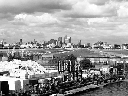
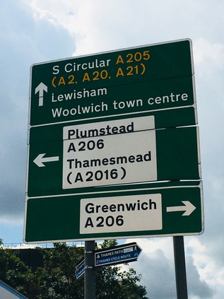
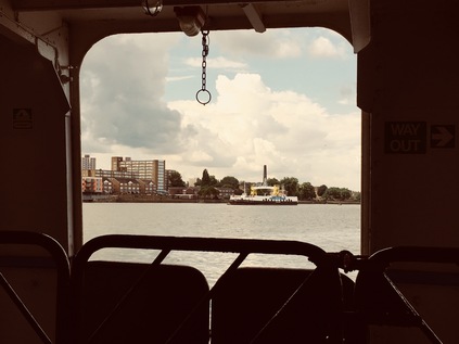
Galleon's Reach DLR Station sits above the roundabout where the North Circular arrives - now known as the A1020 or Royal Docks Road but still signposted as part of the great semi-circle around the city. It's a much quieter proposition here too, as the A13 has taken up the main flow of traffic east and west. The road that I join to head south is signposted 'North Circular, Woolwich Ferry' and immediately rises to cross the Sir Steve Redgrave Bridge over the Royal Albert Dock. It feels good to be walking at last in the morning sunshine, the heat haze rippling the runway of London City Airport as I take in the impressive, sweeping view - the distant city, the towers on the Isle of Dogs and the bulk of Tate & Lyle's plant in Silvertown. Beyond them I see green tree-lined slopes on the south bank of the Thames and I realise that I'll soon be climbing into those unknown parts. 'South of the River' - an old cliché, but a strangely accurate one perhaps. Who goes south of the river in lieu of the apocryphal unwilling taxi driver? Shady characters with bodies to bury, corrupt coppers working a scam and selling the story, semi-gentrified comedians and artists who grew out of Shoreditch? I'm aware of my prejudices and trying hard to push them aside. When I've walked the Thames Path or the Ridgeway I've found the southern boroughs surprisingly diverting - but gazing at my map before leaving I see only an unknowable expanse of suburban streets. I have to convince myself that the East felt equally impenetrable and blank once too. The road is silent as I turn west into North Woolwich. I can hear distant giggles and shrieks of playing children in Royal Victoria Gardens and smell late breakfast being prepared in the fine row of redbrick terraced house on Barge House Road, but there is no sign of anyone on the street. This is still the North Circular - as confirmed by the signs for the Ferry which impose prohibitions on explosives, corrosives and other dangerous materials. Such cargoes are consigned to heading east to Dartford to try their luck on the bridge, or the Blackwall Tunnel which is inexplicably signposted hereabouts like it's just around the corner. Nowhere on the circuit has the road ever been deserted completely, until now. I passed the impressive columns of the 1854 railway station building, now derelict yet again after the closure of the museum, and beside it the site of the tiny utilitarian platform I'd used just before the railway closed here in 2006. At this point I had a decision to make: to take the foot tunnel under the river which descended from the solid, brick rotunda ahead of me, or to turn the corner and wait for the ferry. I decided to stay above ground - true to the route of the road, and to take advantage of the rare chance to cross the Thames by boat. The rather workmanlike ferries are not designed for sightseeing during the brief crossing, and with a small group of other pedestrians I was directed below deck and told to remain seated while cars and trucks rumbled onto the ferry overhead. From the open side of the ferry I could see us slowly pushing away from the north bank, passing the former Steam Boat Pier which once served the Great Eastern Railway's short-lived competing ferry service, and turning south. The silvery carapaces of the Thames Barrier gleamed to the west and the forest of tall, new buildings which now formed an almost unbroken chain into the city marched into the middle distance. And so, as we docked at Woolwich Pier the missing link was complete - by means of a convoluted bus ride, a walk and a boat trip I'd approximately tracked the final few pedestrian-unfriendly miles of the North Circular to the banks of the Thames. Beyond the ferry terminal a long straight road could be seen heading uphill and away from the river. It was time to explore new horizons...
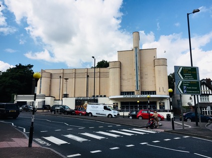
And so the South Circular began. It's important to note just how different this road is to its northern counterpart. While long stretches of the North Circular are purpose-built to near-motorway standard using the geography of London's brooks and rivers to snake swiftly around the suburbs, the plan for the South Circular never quite made it that far. While some sections where the route crossed open, easily purchased land were improved in the early twentieth-century zeal for roadbuilding, other sections simply plot a tortuous route through suburban streets climbing steep hills and crossing major roads at junctions which regularly snarl into long traffic queues. The South Circular isn't so much a road as a route - a collection of sign-posted fragments which attempt to provide drivers with a barely optimal route through a dysfunctional network. Skipping from urban centre to urban centre, the road was only ever going to be a temporary measure. Patrick Abercrombie's ambitious Ringways should have swept all this away - including great chunks of the suburban sprawl I'd be walking through. This ambition for clearing a new path never chimed with public opinion, and was ultimately the downfall of the plan. By the early 1970s the road's fate was sealed - there would be little done to improve the South Circular beyond minor tweaks to priorities at junctions, and while each was probably a minor triumph for a harassed planner, there was no overall strategy. A final attempt to radically alter the road network in the south was detailed in the Roads for Prosperity White Paper in 1989, but like many of the schemes in that ill-fated document, they had disappeared by the change of government in 1997, quietly disposed of to avoid further public disquiet and an emboldened environmental lobby. My walk around this odd historical aberration would be different too - indeed it felt more like the process of charting a lost river running between suburbs than that of walking a grand highway around the city. The road did however have a somewhat more attractive beginning than the North Circular: ascending from the roundabout near the ferry terminal one of the few purpose built sections of dual-carriageway on the route curves between two places of worship which have co-opted former palaces of entertainment. On the left of the road, its solid brick back facing the road, is the former Granada Cinema - now the Christ Faith Tabernacle Cathedral. This impressive modernist building opened in 1937, with a luxurious interior which has been mostly preserved by a succession of new tenants including, inevitably, a bingo hall. Luckily, the location has remained in almost constant use, and its current owners have gone to some effort to source fittings and furnishings from the same makers as the originals. In cinema's golden age of studios sparring for the best stars, across the street the striking art-deco Odeon Cinema set up shop in direct and defiant competition during the same year. The Odeon survived a little longer as a cinema - becoming the Coronet in 1983 and later being altered to include a second screen. A short time after its final closure in 1999 the New Wine Church purchased the building to become Gateway House.
As I began the climb away from Woolwich High Street between these two impressive temples of earthly delights which have bucked the secular trend, I spotted the rear of the Royal Artillery Barracks up ahead. It was here where Wellington Street meets the South Circular that Fusilier Lee Rigby met his untimely end at the hands of Islamist terrorists in 2013. The site isn't formally marked - there are memorials elsewhere in Woolwich now - but the concern that any marker on this ill-fated spot might become the target for extremist abuse seems unfounded. The railings beside Elliston House remain an unofficial memorial, adorned with St. George Cross and Union flags, scattered with flowers and tributes. The site is tidy and well-kept, flowers fresh and flags clean - and it has been kept this way by locals since the terrible events took place. Sometimes, memorials are spontaneous and simple, rather than resulting from grand municipal gestures. It was sobering to cross the eerily traffic-free rise of the South Circular to find this spot, a quiet urban corner on the edge of the leafy barracks site. I wondered how I should write it into my account - whether I should let it pass unremarked out of quiet respect? This is after all an account of a journey which, though opinion intrudes, tries hard not to stray into polemic. But there is no doubt that this corner has become a part of the story of Woolwich and it felt wrong to pass by without contrasting the quiet suburban scene I found with the act of incalculable violence which took place here. My patriotism is tinged with realism and a sense that in an open, well-connected world we can likely never again presume to close ourselves away from the affairs of other places - but when they are brought into our lives screaming hatred and discord, it should never ever be quietly accepted. A little further up the hill, beside the road is the Royal Garrison Church of St. George - almost destroyed by a flying bomb on 13th July 1944, this spectacularly decorated church was originally erected to support the moral and spiritual well-being of the artillery officers stationed at the Barracks, largely in response to the outcry about conditions servicemen faced during the Crimean War. The remains of the church are carefully cared for, with a large arched roof erected to protect the remaining mosaics from the elements. The church is sometimes opened to the public, and inside Fusilier Rigby is commemorated alongside other Artillery officers who have fallen, including those killed by the IRA at the nearby Kings Arms public house in 1974. The ornate, multi-coloured brick pattern of the church is the work of the Wyatt brothers, and sections of the walls still stand to give some idea of how grand this place once was. This was definitely somewhere to revisit on one of the rare opening days, and a fitting place for a more official memorial.
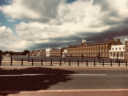
Outside the church, the South Circular has for the first time diminished to become a single-carriageway road. To the west, the broad expanse of the parade ground in front of the grandiose front elevation of the Barracks is empty and quiet, stormclouds rolling overhead ominously. I'd been promised thunderstorms, but so far my walk had been warm and dry. Traffic zipped by the broad pavement, untroubled by queues. This felt so strangely different to the experience on the A406 where the pedestrian was relegated to the fringes of the route, suffered angrily by the traffic. At the improbably named Ha-Ha Road I briefly wandered onto Woolwich Common. This expansive and semi-wild area of grassland was once part of a much bigger tract of open land belonging to the Manor of Eltham, with encroachment towards the currently remaining common area taking place in the 18th Century. A portion to the north became Barrack Field, while to the south east, the Royal Military Academy claimed land, opening to recruits in 1806. A less permanent but equally audacious land-grab took place in 2012, when the temporary structure of the Olympic Shooting Venue was erected on the common. Today the common was busy with people walking or sunbathing, ambulances occasionally darting along Ha-Ha Road towards the Queen Elizabeth Hospital which loomed on the eastern edge of the land. Moving south, the common is divided by the South Circular with the triangle housing the former Academy now part of an exclusive, gated community known simply as The Academy, Woolwich. The pinnacled towers of the central block rising against the backdrop of the wooded slopes of Eltham Common and Oxleas Wood, looking not dissimilar to those of the Tower of London. On the western side of the common the smaller but equally fine buildings of Victoria House, the former Medical Corps. officers mess stood in an isolated crescent on the corner of Shooters Hill Road. This fine but oft forgotten building has provided additional accommodation for the popular Greenwich Free School in recent times, and may at some point form a more permanent part of a new Primary School extension. For now though, it sits a little unloved in an overgrown and wooded corner of the common, fronted by a solid and smart but very firmly closed block of mid-century public conveniences.
Shooters Hill Road stretched arrow-straight to the east and west, tracing the path of the ancient Roman Watling Street from Dover to London. I remembered the couple we'd met on our visit to the Edith and Harold statue in St. Leonard's who said they lived near here, and despite retiring and the possibility of moving almost wherever they wished, had never wanted to leave. Shooters Hill Road was markedly busier than the South Circular here, which seemed very much the minor player at the crossroads. The steep hill rose away to the east, towards the strange Gothic folly of Severndroog Castle. This monument to Commodore Sir William James and built by his wife, takes its name from a corruption of Suvarnadurg - the local name of an island fortress near Goa of which James commanded the successful overthrow in 1755. Run as a tourist attraction by the London County Council in the early twentieth-century, the building passed eventually to Greenwich Council who finally decided they could not fund the upkeep. Derelict and boarded up since 1988 the folly fell into disrepair and its future was threatened until a preservation group formed in 2002. Happily in 2014 the doors once again opened to the public. Looking back along Academy Road, it was remarkable how steeply I'd climbed from the Thames. Here the route began to turn gradually west, and the land sloped gently down into the valley of the Quaggy River. It was hard to recognise the strategic importance of the route from its appearance here - two lanes of traffic with broad expanses of bus lane filling much of the carriageway. Motorists were regularly reminded of the route of the road with South Circular A205 signs nudging them in the right direction when it wasn't entirely obvious where to go - which was fairly often. The road ambled through pleasant suburbs, with decent housing lining the route not unlike that around the North Circular - if perhaps a little quieter and less battered by road grime. At Well Hall Roundabout I briefly stopped for provisions at a Tesco Metro housed in yet another disused cinema building, this time the Well Hall Odeon built in 1936, becoming the Coronet in 1981. The building fell into disuse from 2000, but now forms part of a modern development of shops with an entrance hall and sweeping circular canopy topped by a glass staircase tower still betraying its origins as a theatre. Leaving the store I reoriented myself and turned onto Rochester Way, the 1927 route of the A2, where the South Circular immediately veers off at a crazily arranged junction. It's a short walk to the new course of the A2, a wide elevated viaduct taking the road above the A205, with the railway crossing soon after. A train accelerating away from the 1985 resiting of Eltham station crosses the scene, passing near the elegant planned gardens of Well Hall Pleasaunce. Suddenly, at last, the road is busy. After miles of almost eerie quietness, the South Circular is a clogged, groaning mess. Traffic nudges into lane, drivers apparently surprised by the complexities of the interchange, set against a backdrop of a terrace of almost cartoonishly textbook mock-tudor villas. Traffic noses under the bridges, slowly emerging to the west. Suddenly I'm again walking a suburban dual carriageway flanked by mid-century houses arranged along a separate access road. Sadly this access road obscures the crossing of the Quaggy River, a tributary of the Ravensbourne which has flowed south and east from Lewisham. I pause at a rank of urban shops, watching the drama unfold as a local carelessly shunts a car into a bollard in a low speed collision, shrugging their shoulders then disappearing into the Co-op.
The gathering storm clouds are massing to the north and west, and while for a time I'm in the bright halo of sun on the edge of the churn of brownish-black sky a tell-tale change in the wind signals that I'm not out of danger. Soon enough, large cold raindrops start to patter around me as I walk onward, the land rising again beyond the Quaggy. A rusting sign hangs over the footpath, welcoming me to the Borough of Lewisham somewhat unconvincingly. On a memorable passing over the border between Greenwich and Lewisham once before, I was ceremonially blessed with a huge steaming pile of dogshit. Today it may be a watery tribute instead. It feels like I'm outpacing the storm, but distant rumbles of thunder and the unreal flashes of lightning inside the bruise-coloured clouds signal a downpour. When it finally comes it's sudden and intense - a typical summer storm. I hunch into the roadside under the overhang of a tall hedge near Burnt Ash Hill. The gullies of the road swiftly give up and flood with rainwater - the traffic does much the same in apparent sympathy, trailing into a single, sluggish carriageway running slowly through glum, damp suburbs. Eventually, the rain rather suddenly relents as such intense storms often do, and the ionised air is fresh and clear. I returned to slopping along damply, a soaking from a passing white van now the biggest risk. Luckily for the most part, the pavements were broad despite the narrow road. This area felt forgotten and somewhat lost - not quite Lee and not quite Hither Green, hemmed in by railways and not really on the way anywhere. I know the name Hither Green from my railway travels, but often wondered at its origins - thus I'm amused to see that a nearby street is named 'Further Green'. A low railway bridge ahead of me narrows the road even further, traffic snarling instantly at the lights which control passage. I edged under, staying as far away from the sizeable puddle where the road dipped to pass under the railway. Emerging into the light, the rain seemed to have passed completely and the clouds were rolling away to the north. A weak sunshine was breaking through the gloom ahead, though the road was less than bright. The long straight road headed directly west, a narrow avenue which was adequate on a quiet Saturday afternoon but would clearly buckle under peak traffic conditions. It was easier to see here how this road gained its poor reputation. I put my head down and walked, noting again the carpet of squashed sloes which seemed to have littered the route all the way from Woolwich, a carpet of lurid purple squelches on the grey flagstones.
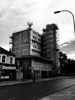
I'd begun to tire early - a little like my first outing on the North Circular in fact - and couldn't pin down quite why. Perhaps it was the delayed start to the walk which had sapped my energy, or the strange and oppressive atmosphere before the storm. Maybe though, it was just the long uphill slog which had formed the early part of the route. In any case, I'd already begun to consider where I'd leave the A205 today. One option was Catford - with two railway stations on separate lines which tangle around each other both offering escapes from the road. Arrival in Catford wasn't inspiring however - Brownhill Road became a dull, urban arterial running between sadly rather run-down terraces of large, once rather grand Victorian homes. The rakes of green bins outside each property signified their new status as houses in multiple occupation, their front gardens given over to parking spaces or makeshift refuse tips. Up ahead I could see the brick ziggurat of Owen Luder's threatened Milford Towers - the Barbican of the South - stretching across the street. An important building but one which hadn't been entirely successful in terms of living space, the refurbishment of the surrounding shopping centre will soon claim it. Towering in front of Catford was a somewhat ungainly concrete block with a zig-zagging glass stairway tower, curiously staggered curtain walling, and an impressive crop of aerials and antennae. This challenging and strange building was Eros House, another Luder building which was originally intended to be part of a larger scheme. As it stands, it is dynamic but queasily out of balance with its surroundings. Once though, this was the exciting future for down-at-heel Catford:
A monster sat down in Catford and just what the place needed. No offence meant: this southward extension of Lewisham High Street badly wanted stiffening. Now there is a punchy concrete focus [...] The gaunt honesty of those projecting concrete frames carrying boxed-out bow windows persists. It is not done at you and it transforms the surroundings instead of despising them. This most craggy and uncompromising of London buildings turns out to be full of firm gentlenessRegenerating Catford appears to have always been a tricky business - mixed land ownership and a fairly hands-off policy by Lewisham Council until recent times have made for a patchy process which doesn't seem to have reached the lives of most of the residents of Rushey Green - one of the most deprived neighbourhoods in the country. Immediately beside the oddity of Eros House was the Catford Gyratory - a huge squared circle of a traffic island where the A21 to Hastings intersects the South Circular. I took the gyratory in the anti-clockwise direction mostly on instinct which advantageously avoided the circumnavigation of a truly huge Mecca Bingo hall. Arriving at the pedestrian crossing where the road from north to south joined the junction, I'll admit some pleasant surprise. A parade of remarkably smart local stores jostled for business with some High Street names, their facades broken only by the protruding sign for the Catford Centre with a giant fibreglass feline gazing across the street at the old village green. Beyond the KFC and echoing the curve of Catford Broadway with its straggling street market, is the rather wonderful art deco Broadway Theatre. The building fits into an awkward site with some ingenuity and remains in use today. The gothic-style stone features were designed to be in keeping with the style of the former Lewisham Town Hall building, now demolished and replaced with the low concrete sweep of the Town Hall and Civic Centre which arrived in the late 1960s, complementing the theatre's shape if not its decor. These buildings too are now partly redundant, with the confusingly christened 'Old Town Hall' now housing local businesses. Catford surprised me - far from being the butt of 1970s TV comic's gags, or the depressing southern nexus for bent coppers and gang violence which it seemed to suggest in the 1980s, there is a strangely positive feeling to the place. I'm curious to come back and explore a little more.Iain Nairn - Nairn's London - 1966
I left Catford via a crossing of its two railways, each with their own local station - first Catford Bridge on the branch line to Hayes, then Catford - served by Thameslink. Between them the River Ravensbourne wound under the road, soon to become the River Pool for the remainder of its journey south. The railways hug the river valley here, using this notch in the landscape between Catford and Forest Hill to escape from the gravity of London. To the south, the pristinely mown playing fields of St. Dunstan's College line the edge of the South Circular as it rises gently to the west. I'm immediately back in suburbia as soon as I've passed the impressive College buildings. It feels like a long, hot slog now to Forest Hill where I've decided I'm going to end today's walk. As I make my way along the street pursued on foot by a hurrying bridegroom and his driver who appear to have either broken down or decided to flee the scene ('there's nothing here, no shops, no garages, NOTHING!') I spot a removal van at the side of the road which appears to have come all the way here from my coastal hometown. I glance at the driver, who looks back - but there's no recognition. Why would there be? We'd neither expect to see a familiar face on this most inconsequential stretch of road. The road curves, thrown off line by the need to cross under another railway up ahead at an awkward point. The course of the route is so improbable here that even more of the regular signs are needed to remind the driver: A205 South Circular. It feels at times, as I've tried to follow the route of this odd, almost makeshift way around London that the signs are trying to convince us that there really is a road, that we haven't just imagined the South Circular by means of some collective, hyrdrocarbon-induced hallucination. This is a route which does what you'd least expect and often at the most inconvenient of times. It echoes perfectly the often truculent, sometimes wilfully perverse and always darkly humorous south-of-the-river character. I climb the surprisingly steep rise to Forest Hill station and shuffle tired feet onto the platform just in time for a London Bridge service. Just like my first attempt at the North Circular I feel the road has beaten me today - I didn't get as far as I'd hoped by any measure. But perhaps that's how these roads work - they're designed not to be taken as a whole, because they're never the most direct way between two points. They are experienced piecemeal - fragments of a journey on route to other places. Who would be stupid enough to try to walk their entire length? Before we depart I take note of my surroundings in preparation for another ritualistic future reconnection with the route. Soon, the train clatters into the much-modernised London Bridge station on the edge of the City of London - a station I haven't used in a good many years - and I navigate my way through the unfamiliar concourse out into the sunshine bouncing from the lower tiers of The Shard. It feels a long way from the ferry, and even further from the curious centre of Catford.
You can find a gallery of images from the walk here. Or you could explore the first and second parts of the North Circular.
Lost::MikeGTN
I've had a home on the web for more years than I care to remember, and a few kind souls persuade me it's worth persisting with keeping it updated. This current incarnation of the site is centred around the blog posts which began back in 1999 as 'the daylog' and continued through my travels and tribulations during the following years.
I don't get out and about nearly as much these days, but I do try to record significant events and trips for posterity. You may also have arrived here by following the trail to my former music blog Songs Heard On Fast Trains. That content is preserved here too.
