Zealotry and Gentrification: An Alluvial Pilgrimage
Posted in London on Saturday 1st September 2018 at 11:09pm
Arrival in Erith did little to dispel the strange gloom I'd sensed about the place on my last, fleeting, Sunday afternoon visit. Back then I'd been content to assume it was shuttered and drab because of the malaise which descends on all British towns on the afternoon of the Sabbath, thanks in part to antediluvian trading laws. While there were more people milling around the town centre today, the place still felt rather hopeless and grim. I headed under the main road and into town, soon being accosted by a group of Christian proselytisers who were hawking glossy cards urging passers-by to join them at an event. A loud choir was lending support by belting out hymns in the pedestrianised walkway. I slalomed around this, passing a string of little cafés with steamed windows and plastic-draped tabletops. The locals sat outside, smoking prodigiously and gazing into the middle distance. The morning was heating up already and I decided that I was going to need supplies from the nearby supermarket before beginning today's walk. I already felt like I was behind schedule after the long train journey out here, so I tried to make this a swift visit. Even in the huge Morrison's store, I was struck by the utter gloom of Erith. As I passed the in-store restaurant a minor scuffle broke out over ownership of a winning lottery scratchcard. I felt this very paragraph forming as I headed out of the store, knowing I'd need to compound my earlier remarks on this beleaguered spot and already feeling uneasy about it. It felt uncharitable to knock a place which was so clearly out-of-luck and on the edge of things. Once out of the store I made a dash across the fractious carpark where drivers wrangled into tiny spaces, and on to the waterfront. Soon, thankfully, I was beside the Thames. There was an unexpected relief in seeing the undulating rubbish-mounds of Rainham across the quiet waters and the strong sunlight reflecting back at me from the slick silver-grey mudbanks exposed a low tide. I turned west and began to walk with little expectation and only the loosest plan for today.
The Thames Path is broken at Erith, diverted inland to skirt industry around the Darent estuary, then occasionally reappearing as a plaza at the front of the tall blocks of modern apartments which have gradually filed into place along the waterfront. The Thames takes a turn to the north at Erith Reach and the foreshore returns to industrial use, meaning the path makes a zig-zagging course around the heads of various abandoned docks and inlets. I set off, pleased to be on the river for a brief spell at the start of the walk, and only mildly inconvenienced by the cyclists who attempted to negotiate the 90Ëš turns at the blind corners of these twists in the path at full speed, skittering to a halt as they misjudged their angle and encountered a pedestrian. The path opened out to run along the well-kept but rather sunburned edges of Riverside Gardens, a park laid out on the site of a former flour mill which is itself now threatened as the land is a prime riverside residential site. The walkway along the wharfside which formed part of Henry VIII's royal dockyard has a rather ill-chosen name in some senses. William Cory Promenade is named for a local collier who realised that he could avoid wharfage fees by unloading coal onto barges and lighters in mid-stream along the relative calm of Erith Reach, thus denying the town of employment and income, despite maintaining his base in Erith. As I turned a particularly grim looking corner where the path passed around a rusting crane and disappeared behind a forbidding looking fence, I met a dog walker who seemed distressed. She appeared to walk by before thinking twice and calling agitatedly after me to ask if "I knew anything about the horse?" I must have looked entirely confused so she gestured urgently to a gap in the corrugated iron beside us, through which a large, sad brown eye was gazing back at me. In a grubby scrapyard, marooned between the fence and the dock wall was a young pony, tethered and a little grubby looking but otherwise apparently healthy. I took some pictures and suggested I could send them to the local RSPCA. She seemed a little happier at this prospect and declared her intention to find the horse some grass to eat. We headed off in opposite directions to complete our missions. A swift email sent, I reluctantly turned aside from the Thames where the path ducked inland again. While I still felt I had business in Thamesmead which occupied the broad headland between Crossness and Erith, today wasn't the day. Instead, I intended to cut across the territory I'd begun to walk some months back but abandoned in the heat. It was likely to be no less hot today, but tackling the wooded hills of North Kent would surely be easier when I was less exhausted at the beginning of the day. The path led me beside the old church of St. John the Baptist, which has likely existed in some form on this site since Anglo Saxon invaders moved into the territory abandoned by the Romans and founded towns and farmsteads along the Thames. The church was squat and solid, situated in a cool and shady churchyard which, now disused, was returning to nature. This quiet spot, now largely marooned in the shadow of the passing dual-carriageway, was once at the heart of Erith - but the town crept slowly south along the river towards the wharves and docks leaving St. John's here on the edge of things.
My path out of Erith involved the ascent of a rickety and somewhat litter-choked footbridge over the A2016 Bronze Age Way, which didn't appear to be used a great deal despite the challenge of passing this man-made barrier across the marshes. The busy spinal route takes traffic from the M25 into Thamesmead and seemed to flow remarkably busily beneath my feet. From the top of the bridge, I could see rising woodland to the west, and I confess to some trepidation: the day was getting hotter and my resolve for hill-climbing was weakening. I focused on how cool the air would be under the trees and descended from the bridge, beginning the climb of Valley Road towards the entrance of Franks' Park. This wedge of rather untamed woodland has been a fixture of these growing suburbs since the 1920s and remains generally little-changed. When Frank Beadle, local industrialist made-good, sold his business to Cory & Son in 1896 he played a part in kickstarting the massive Cory Environmental enterprise which transports, recycles and incinerates waste to this day, and not without controversy locally. Beadle's family later donated a substantial parcel of land to Erith Urban District Council - an area of woodland climbing the ridge of Lessness Heath which offered an impressive vista over the Thames. This lofty and isolated site had provided the ideal site for Belvedere House, built in the 1770s and later the home of philanthropist and campaigner for religious freedom Sir Culling Eardley. Much of the growth of Erith and Belvedere is due to Eardley's willingness to sell parts of his estate to develop decent housing for the rising middle classes in Kent, and to this day there is a distinct separation between the 'village' of Upper Belvedere on Eardley's lands and the former wharfside settlement of 'Picardy' - now known as Lower Belvedere. The grand house was sold to the Royal Alfred Seafarer's Society in 1865, finally providing them with a rest home for 'worn-out Merchant Seamen' which had been their goal for some years. It was demolished following a lengthy public enquiry in 1959 to make way for a modern facility for the charity which offered better accommodation, an 'Infirm Wing' for less able residents and staff quarters on site. This rather fine modernist building was soon found unsuitable: with declining numbers of residents and a cohort of users who were often now less able or ambulant, the Society acquired a more traditional convalescent home in Surrey. The modern Belvedere House was, in turn, demolished too and the site is now covered by a housing estate - a spaciously arranged redbrick crescent of 1980s vintage which climbs the valley of the now barely-extant Bedonwell Stream, looking resolutely provincial and unlike the usual homes in this part of London. Frank's Park, however, has changed little over the decades and much of it remains ancient, gloriously ungoverned woodland. I thrashed along for a while on the path which was pleasantly busy with Dads teaching children to cycle and 'phone-checking dog-walkers ambling behind their charges. Faced with a choice of climbing higher into the woods or edging along the inhabited fringe of the park, I chose the latter. I was curious about Erith and Belvedere and disappearing into the trees too soon wouldn't help me get a sense of the place. Instead, I walked a narrow path overhung by trees until I reached a cleared field in the middle of the park where I was decanted onto Parkside Road, the unadopted, rough track which caps the long terraces leading towards the heath from Lower Belvedere.
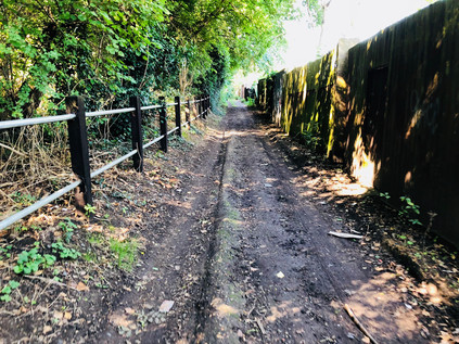
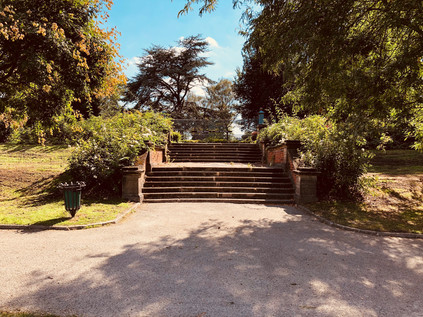
The intriguingly named Halt Robin Road felt like a country lane, disappearing into the dense western edge of Franks' Park before emerging to cross Picardy Road. This ancient thoroughfare snaked down the hill towards the marshes at the edge of the Thames, linking Upper and Lower Belvedere and likely becoming a much more significant route following the coming of the railway station to the flat land at the foot of the hill in 1859. I headed west again onto Upper Abbey Road, a rather odd little lane which dipped into a shallow sided gully before climbing steadily towards Heron Hill, a spur striking south from the ridge of land on which Lessness Heath sits. The heath was once a much wider expanse of open land, but even by the time of the Domesday Book, a settlement here recorded the largest population for some distance around. The origins of the name are debated - but it seems likely that it incorporates the Old English term for a headland with hlēosne - burial mound. Certainly, this stretch of high ground which is now largely carpeted with suburban homes has been a site of both ritual and more prosaic activity for thousands of years. At Heron Hill, I noted that I was again following one of the spurs of the Green Chain - and that other, more dedicated walkers were following the route too. I trailed a well-equipped, back-pack wielding fellow down the hill and into the inconspicuous entrance to Abbey Wood, one of the largest remaining tracts of the once vast expanse of heathland. There was a choice of paths here - to strike directly into the woodland and follow the undulating and circuitous paths under the trees, or to take the quiet country-lane like track which ran along the edge of the forest of tall, venerable trees. I took the later while my fellow walker headed into the woods - I knew I'd be heading uphill at some point soon, and putting off the clamber for a little longer couldn't hurt. The lane wound quietly along, mostly deserted but for a brief spell, I did follow an incongruously well-dressed man who ambled along the muddy, rutted path ahead in a fine suit, casually tossing away peanut shells as he snacked and walked. At one of the irregularly spaced opportunities to pass through the fence into the woodland, I decided it was time to plunge into the trees. I found myself on a well-made track which there was no hope of straying from, as well-hidden but sturdy wire barriers ensured that only the official routes were walked in Abbey Wood. The path bucked and weaved through the cool woodland, occasionally arriving at confusing junctions where either too few or a confusing profusion of waymarkers made my route ahead unclear. My aim was to head for the remains of Lesnes Abbey - an ending I'd trimmed from an earlier walk, but a place I was keen to finally visit. The path rather unexpectedly opened out into a broad, green area fringed by dense, rising woods to the south. In the midst of a natural bowl in the ground, the impressive ruined stone walls of a sizeable estate of buildings cast shadows on the grass. Lesnes Abbey was founded in 1178 by Richard De Luci, then Chief Justiciar of England - and the act may have been part of his penance for involvement in the murder of Thomas Becket. More certain is that this was neither a populous nor a prosperous Abbey, largely due to the costs of draining the surrounding marshes for farmland and shoring up defences against the Thames. Lesnes was one of the first ecclesiastical sites to fall after the Dissolution of the Monasteries in 1534 and soon returned to farmland. The site passed through various owner's hands over the following centuries and was often robbed for building materials - not least for Hall Place in Bexley. The site has been a public park since 1931, when it was purchased by the London County Council, and the well-kept grassland and striking profile of the ruined abbey walls against the trees provide a sense of the age of the site. The park was busy with walkers and sunbathers, the flags of the site's café flapping in the breeze. I contemplating resting awhile here - but it felt too early in the walk and I was intrigued to head instead for the impressive concrete footbridge and walkway which led north from the site, over the busy Abbey Road and the railway, and into the fringes of Thamesmead. A steady stream of locals made the long walk over the elevated walkway into the heart of the park, arriving near the protected Mulberry Tree, the aged trunk of which contorted over the ground. Said to be a survivor of the initiative by King James I to create a native British silk industry, the tree is delicate and carefully managed now. I was impressed by Lesnes Abbey - the park was well-managed and clearly popular, and there was a carefully maintained balance between history and amenity in evidence. I headed out via the west gate, passing a carved statue of an Abbot in a grove of trees, rather sad to be leaving.
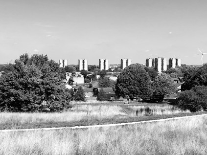
The time had come for my ascent onto the top of Bostall Heath. I'd been avoiding this climb throughout the walk so far, likely put off by a memory of approaching the hill from the west at the end of a prior excursion and seeing buses creeping slowly up into the heat haze. As it happened, the climb was challenging for less expected reasons: eschewing what could have been an easier route via New Road or even the designated walk along the Green Chain, I decided instead to head along an intriguing public footpath which disappeared between the houses under an arch of trees. The walk was challenging - a steady but steep climb through a rutted, humid midge-infested tunnel between the trees, worn down by walkers over the years but almost abandoned today. It was suggested that this was some sort of route of pilgrimage to the Abbey, but it was hard to assess the provenance given the preponderance of religious links in the area. At the top of the rise the path rather abruptly ended against a railing beside Knee Hill. This much busier route between the low-lying settlements near the river and the top of Bostall Hill had no footpath to speak of, and I soon found myself climbing the road in short bursts of frantic walking, stepping into the heavily-littered undergrowth to allow a stream of vehicles to pass, before skittering forwards for a few more yards. The short walk up Knee Hill felt like a long, taxing drag, but my concern to remain safely out of traffic meant that I barely noticed the ascent of the hill which had been my chief concern. Near the summit I was able to divert briefly into Bostall Woods, noting with some concern the signs indicating a grid system for alerting the emergency services to ones' location should they be required to find you among the trees. I finally emerged on Bostall Hill, a plateau of level ground at the top of the long, steep rise from the west. The road snaked downhill, surrounded by trees on both sides, but with a tantalising glimpse of London on the horizon between the greenery. Walking downhill has always been a trial for me - my innate clumsiness and heavy-footed trudge turn into a momentum-fuelled stagger and I'm excessively conscious of my efforts to remain upright. As I've grown older and heavier, I've also noted that the forces at work on my knees feel far more disagreeable when stumbling down a hill. I steeled myself for the usual vague feeling of lost control and set off, passing the fine Victorian Heath Keeper's cottage which was built in 1880 after the Metropolitan Board of Works purchased the land to save it from the creeping tide of housing engulfing the area. Beside it, a fine granite vessel inscribed by the Metropolitan Drinking Fountain and Cattle Trough Association stood, filled with flowers which fared remarkably well despite the busy road nearby. The trough was not original - while the Association indeed placed a much-needed trough here for horses which had hauled coaches up the long, arduous climb, their records indicate a 9'6" long trough. This truncated replacement is of uncertain origin - but marks the brow of the climb well enough. The common land was extended in 1894 by the addition of Clam Field, and as the suburbs slowly engulfed the woodland, the mythology of the place grew with them. These ancient and mysterious islands of woodland in the expanding city always attract superstition and curiosity - and for some reason, almost all of them have apparently attracted the notorious Dick Turpin. The presence of chalk workings on Bostall Heath have provided a rich backstory of the dashing highwayman hiding-out in caverns between raids on rich folk climbing Shooters Hill. The reality of Turpin is, as I've discovered elsewhere, that he was neither quite so dashing nor so elegant in his practice. It seems in fact that he was a thug first and foremost, and while it's possible he did know these woods well enough to disappear into them when needed, the purpose of the caves is more prosaic. Chalk has been worked in North Kent for many hundreds of years, and the outcrop of land on which the heath sits is home to numerous abandoned pits where it has been dug. In 1899 the Royal Arsenal Cooperative Society began work on the Bostall Estate - a development of homes on the site of their former market gardens - excavating an eventually very extensive network of passages under the heath to extract chalk for the building works. The mine was abandoned in 1906 before briefly becoming a First World War air-raid shelter. Despite improvements to access, it was not reused in the Second World War due to frequent roof-falls and despite protests that it should be opened to locals. The tunnels were later sealed and the gardens are long disappeared under suburban streets, but the Cooperative Society continued to own land and property in the vicinity, eventually selling their large property Shornalls to the Greenwich & Bexley Cottage Hospice in 1988 for the princely sum of £1. A much-expanded community hospice still operates today, surrounded by the peace and quiet of Bostall Heath.
At the foot of Bostall Hill, Wickham Lane snaked away to the south - a venerable way across the heath towards Kent, and a boundary of sorts. Beyond here the quiet of the woodland gave way to a continuous strip of suburbia heading directly for London. Plumstead High Street stretched away into the distance between two long terraces of local shops, small businesses and housing. I began the long march west by falling foul of an angry van driver: as a few pedestrians including myself waited to cross at a light we noted that the driver at the front of the queue was busily composing a text message and paying no attention to the light which began to change back from red to green. We made it across the street safely before she realised and sped off at the last possible moment. The van driver recklessly sped after her, assuming that she'd waited because we were crossing in front of her. I responded to his volley of foul-mouthed abuse with a raised middle finger, which seemed to enrage him even further - but he was now gunning his van at alarming speed along the High Street and couldn't have stopped if he tried. I exchanged smirks with a fellow insulted pedestrian after one of the road's little victories for the day - and set off again. But this wasn't to be my last encounter on Plumstead High Street. As I trudged along a stretch of busy pavement beside a run of well-kept retirement flats and small shops a young, confident woman in a pristine London 2012 t-shirt flagged me down. I was momentarily bewildered by this - partly because I rarely expect to be stopped in the street here, but mostly because I thought it impossible that anyone would have kept a t-shirt in such impeccably good order for six years. Indeed, she would likely have been a small child back then based on my estimate of her current age. The sight of that logo here in London, beneath an open and hopeful, smiling face took me back to the summer of Gamesmakers and their jolly oversized pointing-hands. The bonhomie of that fateful summer was real even if the park and the event were a facade - those volunteers who jigged and capered their way through two long weeks of irritable queues and misdirected tourists meant every bit of their happy smiles. And so did this young woman who was, it seemed, about to ask me about my relationship with Jesus... I was wrong-footed enough to drop my guard and to answer the first question honestly: yes, I had been christened. I didn't get the chance to tell her about my long quest to get the Bishop of Worcester to reverse my baptism or my long association with atheism. Before I could trot out the familiar defences she was telling me how my soul could be saved with a swift prayer she was happy to say with me right now. Jerked back to reality with the realisation I was meant to respond to this suggestion, I counselled caution - shouldn't I be reflecting on such a weighty issue rather than committing foolishly to this course of action in the street? She bit her lip and pondered before agreeing that forming a personal relationship with the Saviour was serious stuff. Instead, she thrust a number of booklets into my hand, circled the prayer I needed to ponder and asked for my 'phone number because she wanted to invite me to one of the events in the leaflet - the same one that I'd been hustled to attend by way of a glossy flyer in Erith earlier in fact. I trotted out a string of random digits approximating a valid 'phone number and prepared to make an escape. "I'll just call you to make sure I've got it right" she said, raising her 'phone and waiting for the dialing tone. My heart sank. There was no escape - she was good at this, and I'd been exposed as both a heathen and a charlatan. I made an excuse about getting confused with my work number and gave her the real number. She called and checked it, letting it ring once before hanging up and letting me pass, satisfied she'd been able to persuade me into an appearance at this forthcoming festival of evangelism. As I wandered off, a little dazed by this experience and rapidly blocking the number which had just called, I almost felt guilty. It felt a little like being rude to one of those intrepid, cheerful, resolutely un-British Gamesmakers would have surely have seemed back in 2012? Kicking a puppy instead of Lord Coe was a poor substitute. I felt grubby and cruel, but also ill-used - a little like Plumstead High Street felt in fact as I hit my stride again, passing a parade of slightly down-at-heel stores which stretched along the seemingly endless road.
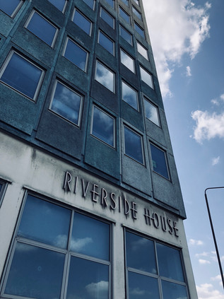
The road rose to divide at Plumstead Station where I crossed the tracks of my previous walks. Navigating the junction involved dodging more religious leafleteers, but I was in better form now and able to evade the extended hands and tune-out the requests to stop and chat just for a sec... Nearby, the Southern Outfall Sewer struck out on its elevated course towards Crossness, and beneath the road the rails curved out of the tunnels which had brought them from London. I'd found myself here numerous times, often unexpectedly when the trains had failed me. Plumstead had that sense of accidental patronage - the newsagents' shops which slumbered between customers might not even exist were it not for the people who ended up here instead of their intended destination. Beyond the station, the dual-carriageway to Woolwich skirted the main drag and described the edge of the former Dockyard. The broad, busy road edged closer to the river here, which was indicated by the distinct absence between buildings. The modern wall of the once fortified dockyard was a long strip of laminated lifestyle prompts - a parade of serving suggestions for modern living in the new apartments rising behind the hoardings, punctuated only by reminders that Crossrail would have been here in December if the project hadn't slipped alarmingly behind schedule. The buildings on the landward edge of the dockyard were modern, low-rise blocks with retail opportunities on the ground floor which sparkled across the street at the decidedly low-rent, tattered edges of Woolwich town centre. I could smell the saline water on the air as the breeze whirled along the dusty pavement whipping up a litter of takeaway cups and discarded religious literature. This road in from Kent seemed to remain a pilgrim's way of sorts, and was still a channel of worship - either fuelled by sincere belief or desperate hope. I recalled the twin modern churches which stood like dvarapalas at the entrance to the South Circular not far ahead which might well be the modern-day sacred site the road was aiming for. But I was turning aside before I reached that junction, crossing the street near the abandoned concrete and smoked-glass municipal offices of Riverside House to head for the river and to speculatively check for a ferry over to the north bank. The terminal was silent, the boats laid up further along the river. In preparation for the switch to modern vessels, the ferry service had been stood-down while work continued on the loading piers. I realised that if I was to continue as I planned I'd have to make a long-promised and often avoided journey under the river. I headed for the rotunda where the descent into the foot tunnel began.
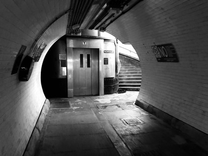
It was hard to classify my unease at passing under the Thames. The evidence told me that it was entirely safe, that generations had made the excursion on foot or bicycle since opening in 1912, and still did in their thousands. I also knew that I'd passed through tunnels in trains and cars without incident, even this very morning. But an anxiety which I've never truly conquered and which seems to retreat to some hidden cells like an inactive virus can be awakened by the most mundane of things. As I descended in the stinking lift-capsule to the subterranean level I was aware of dry-mouthed concern settling on me. A young woman ignored me carefully and deliberately, probably far more anxious than I but hiding it impeccably - and I was momentarily distracted by the sad thought that she had to do this every day perhaps: to pretend that it wasn't menacing to be the only other passenger in a lift with a nervous, shuffling and sweaty man. Experienced in tunnel-navigation she set off at a swift trot as soon as the doors opened. I paced myself carefully, the white tiles stretching ahead endlessly, descending to a mid-river nadir beyond which I couldn't see. I surprised myself by being less concerned with the weight of water above and more with the peloton of reckless cyclists who zapped by in both directions, in contravention of the signs but anticipating TfL's review of the no cycling rule which was imminently to deliver a verdict. My fellow lift passenger had stomped ahead, heels clacking loudly along the floor, staying resolutely to the left of the white line while others walked by in the opposite direction, equally unconcerned and apparently mostly bored by the need to walk rather than chug over in the ferry. The tunnel turned upwards and in the distance, a dark smudge, growing by the step, indicated the dark wood panels of the headwall and staircase on the northern side. I picked up the pace, carefully managing my steps to miss a rather full lift going up and to wait for its next trip. If possible, the northern liftshaft was more nauseatingly smelly than the southern and accompanied by a couple of cyclists, I made the ascent without breathing any more than was necessary. The doors opened and I whirled out of the rotunda into reliably grubby and desolate North Woolwich. I looked around at the few people lingering near the entrance waiting for the lift and realised that none of them would congratulate me for making this utterly unremarkable, everyday passage. I headed up the dusty road towards Pier Road, feeling somewhat energised by my passage under the river after finding excuses to avoid it for so long. I was now in environs I knew fairly well and it felt reassuring to be back on the long road which stretched west along this sometimes ill-starred and isolated peninsula.
I often write of territory which is shifting, contested or liminal - but North Woolwich is perhaps a defining example of this kind of place. Its ownership and fate have been eternally unsettled - an early hamlet here was destroyed by medieval flooding, and a long mess of administrative change resulted in the parish becoming an outpost of Kent in Essex. This confusion was largely fuelled by Hamo de Crevequer, appointed Sheriff of Kent after the Norman Conquest and also gifted lands in Essex and Surrey. To facilitate more efficient taxation and control of the ferry across the Thames, he established an extenstion of his manor to the north bank. When the parish boundary was drawn based on the old manorial lands the anomaly persisted. The creation of the London County Council did little to resolve things - the Metropolitan Borough of Woolwich was absorbed by the new County, while the Boroughs of West and East Ham which surrounded North Woolwich remained in Essex. The ancient anomaly was finally tidied up by the creation of the London Borough of Newham in 1965, around nine centuries after it had originally arisen. With the old settlement long washed away, for many of these hundreds of years the territory north of the river had been a wild and mostly uninhabited waste, unimportant and easily ignored - not until the 19th century did the population here start to increase, as industry and dock construction processed east along the river. Cable-making and shipbuilding brought a new working-class population to the area, and North Woolwich became briefly prosperous. The presence of Harland and Wolff's works at Gallions Point and the proximity to the docks made the area a prime target for bombing in the second world war, and the population declined rapidly due to the destruction of homes and the displacement of industry. The factories didn't return, and the wharves became scrapyards, refuse transfer sites and waste lots. Only the mighty Tate and Lyle works at Silvertown remained, engulfing the area in sweet, earthy and rather sickly clouds of fume. The road through what remained of North Woolwich was drab, quiet and mildly threatening in its weekend desertion. The southern edge of the road was marked by a long, concrete wall erected to screen homes from the noise of Crossrail trains should they one-day start to emerge from the earth nearby. It was a depressing structure, blank and oppressive with only occasional pavements to accommodate bus stops. The narrow tongue of land tapered between river and dock, the DLR forming a spine from which the low-rise housing and closed pubs dangled precariously towards the riverfront. The sugar works were silent today, a massive banner depicting a Golden Syrup can flapping unsettlingly above. It sounds odd perhaps, but I rather like the feel of this place and decided to settle on a bench to eat a late lunch and think about the route ahead of me a little.
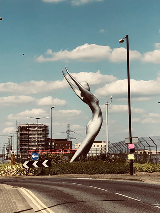
North Woolwich slipped into Silvertown without any sense of change in status, the concrete wall finally turning aside in the Travelodge carpark where the railway tracks dip into the revitalised Connaught Tunnel under the Royal Docks. The hotel itself is a unusual building: a squat, rectangular block with gently curved corners apparently modelled on a vintage transistor radio. The service entrance to London City Airport former a third spur from the junction was silent, the staff idly but suspiciously watching me walk by as I turned towards Nasser Azam's 12-metre tall bronze statue of Athena which graces the entrance to Connaught Bridge. The elegant figure throws her hands back and pushes her body forwards, apparently caught before an elaborate act of bowing down towards the east. This isn't insignificant - the artist wanted to honour the community which had raised and supported him. Athena acknowledges that the city towards which I was slowly trudging had built much of its prosperity on the foundations and the sweated labour of these communities. The statue changes in aspect as I make my way around the roundabout on which it stands: from the front a striking statement of intent, from the side the beginning of a supplication, from the rear a muscular statement of feminine strength. From the bridge, I had a fine view across familiar terrain: the wasteland stretching west towards Millenium Mills, the wind-rippled expanse of the Royal Victoria Dock and the distant towers of the Emirates Airline climbing to cross the river. I turned south and then west, towards Pontoon Dock. In contrast to North Woolwich, much had changed here. The numerous building projects which I've spotted languishing over the years have slowly cranked back into action, the financial crisis finally unpaused for these apartments as far-eastern buyers speculate on the crazy zig-zagging pre-Brexit pound. They still jostled with scrapyards and warehouses, some in use and some abandoned, but people were returning to the penninsula it seemed. The ghost of George's Diner and the Graving Dock Tavern still haunted the northern side of the road, surrounded by a forest of buddleia, but they were overshadowed now by the mighty, ship-like lines of Barrier Point and the sturdy piers of the DLR viaduct. At the entrance to this new development, apparently providing accommodation for students and their visiting family, a gleaming new Starbucks store traded remarkably busily. I slipped in for a much-needed coffee and to plan how far to walk today. The airconditioning was welcome - a chance to reapply sunblock to my sweaty forehead to the apparent disgust of an elegant Spanish family who accompanied their student daughter as she showed them around her temporary home. They looked unimpressed, and a little concerned perhaps? This place felt incongruous - I could see the desolation of undeveloped, struggling Silvertown across the street beyond a coffee shop diorama of MacBook screens and complicated looking iced drinks. Inequality is a strange concept to convey: easy to intellectualise but hard to illustrate without invoking a patronising pathos. But it was here at Barrier Point, and it felt deeply uncomfortable. Aware I was lucky to regard passing through this place as leisure rather than necessity, I swallowed my coffee and moved on to find some good old-fashioned public-spirited philanthropy to ease the middle-class guilt a little. I found it very close by at Lyle Park. This place was an unexpected gem - accessed by a long, leafy path beside public tennis courts, the almost hidden entrance opening into a lush, green square of open space big enough to house a football pitch. A line of trees divided the park, with an impressive brick and stone stair leading up to a terrace on the riverbank. On this terrace, the gates of the Harland and Wolff works which employed locals until 1972 were placed ceremonially between rose beds exploding with colour and scent. The park appeared utterly deserted. Sir Leonard Lyle donated this sliver of land to the local public of West Ham in 1924. It would have been a very significant open space in the crowded, factory-choked confusion of Silvertown in the early 20th century, and a welcome escape for families who lived in relatively cramped conditions. Few lived nearby now, except for those who occupied the new developments and likely hadn't dared explore this far from their front doors yet and the park was unused but beautifully kept. The grass was green despite the long, hot summer and the foliage was carefully tended. Finally, on the range of benches beside the Thames, I spotted another human being - a young mother rocking a pram with her foot while she carried on one-half of an impassioned, frustrated 'phonecall. I quietly took photographs of the river before slipping away and leaving her to her call - Lyle Park was still a haven for the locals of Silvertown it seemed, and it felt right to leave it that way today. Tate might have sponsored the temples of art which graced the banks of the river further west, but Lyle's more modest bequest was still an oasis of calm in a conflicted spot.
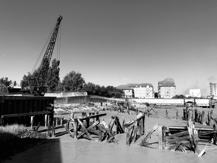
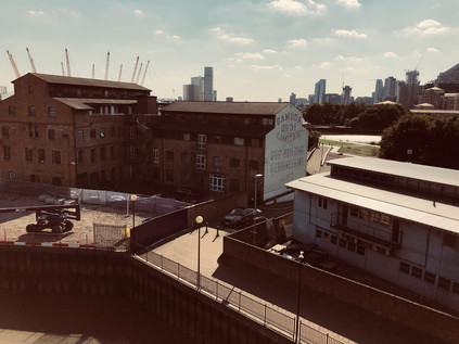
I turned west again, and almost immediately began to climb as the road rose onto the Silvertown Viaduct. Below, a mess of industry - some dead, some clinging barely to life - filled the narrowing isthmus between the river and the dock. By the early years of the 20th century, the approach to the Royal Docks from London was beset by delays and queues which were beginning to hamper trade. The narrow, tight elbow in the road after the Barking Road bridge over the River Lea fed a slow line of traffic onto the long approach road to the docks with an often-opened swing-bridge over the Tidal Basin entrance. Finally in 1929 the Dock Approaches (Improvement) Act passed through parliament authorising historically massive sums of money to resolve the issue. The solutions were elegant and surprisingly long-standing, with the original spans of the replacement Lea Bridge still doing duty among a tangle of new carriageways and slip-roads, and this three-quarter mile long Viaduct over the dock entrance still reflecting the sun back at me from impressive and graceful concrete flanks. At the time of its completion in 1934, there was no other similar road scheme in Britain, and the starkly modern design signified an optimism in the future of the docks which was to be largely misplaced. The Tidal Basin entrance was dry now, one of the towers holding the cables for the Airline occupying space on the former waterway. The cablecars moved slowly overhead in the startling blue sky, new towers of dockland housing rising to meet them as the area to the north of the crossing was gradually gentrified. The view was surprisingly open from the top of the viaduct - over the Thames to the white nodule of the O2 with its own forest of new towers growing around it, and north to the sprouting patch of similarly gleaming new buildings in Stratford. Setting aside any concern over how London could survive these transformations, the effect was exhilarating. It felt like surveying a city-building computer game from inside the screen. Buildings grew almost as I watched, the vista changing with every rotation of the lens. I descended from the viaduct to take the Lower Lea Crossing. It was a walk across this bridge which had, in some ways, rekindled my series of London walks some years back, and reversing the direction felt fitting. I was re-entering a different city now: an unplanned, opportunistic mix of new buildings and new communities, lost history and missed chances. I navigated around the mess of fly-tipping and broken glass which stood as a gateway to the bridge, passing the site where I'd spied people camping in the bushes beside the road on my prior visit. The carriageway leapt forward, over the sluggish, muddy estuary of Bow Creek which curled and writhed below, resisting its confluence with the Thames. On the little headland of Goodluck Hope where the lighthouse at Trinity Buoy Wharf kept a now lightless guard, the warehouses and workshops had been painted with historic mock-ghost signs for businesses long since closed. I spotted one for Samuda Brothers - painted in bold black letters on white, suitably distressed for purposes of false provenance. The connection of Bow Creek with Samuda Brothers - a relatively shortlived shipbuilding firm which was opened in 1843 by Jacob and Joseph d'Aguilar Samuda - was a little obscure. They are much better known for their larger premises on the Isle of Dogs, now the site of the Samuda Estate - but their origins lie here at Leamouth where they leased a yard until 1852 when it proved too small for their ambitions. The company's time here wasn't entirely happy or successful: their first ship, the Gypsy Queen exploded during testing, killing Jacob and nine other employees. A further explosion in 1845 claimed three more lives. By the 1860s, established in new premises, Joseph rode out the financial crisis by securing orders for iron and steel warships from Russia and Japan who were then escalating towards an inevitable war. He died in 1885 and the company failed to sell as a going concern. Shipbuilding would continue here at Creekmouth until 1912 when the Thames Ironworks and Shipbuilding Company closed its gates.
The Lower Lea Crossing touched down at the dusty, windswept roundabout nestled in the corner created by a contortion of Bow Creek and the remains of the East India Dock Basin. I eyed the clock with concern here, trying to decide how far I should press on. I decided to head for Blackwall where I knew I could get a bus back along Commercial Road into the City. This felt like a particularly fitting ending to a largely unplanned walk: to unravel the route I'd just spent weeks reliving as I tried to turn some entries on this blog into a small book. The windshield concrete blocks of Robin Hood Gardens had gone and dust and litter whipped across the path, while the hot afternoon sun beat down on a modern, glass and metal Blackwall. The past was now all but erased here - reminders revealed only to those who knew their locations in privatised walkways and residents-only gardens. I edged through the hinterland of the Virginia Quay development and crossed the broad dual-carriageways of Aspen Way via the footbridge extending from the platforms of East India DLR station. The view from the perspex tunnel was uncanny and arresting - a Ballardian sweep of new, sparkling buildings to the east and west, the road rising from a tunnel and sweeping in a curve towards the city. It felt quiet and abandoned today, waiting time for the next week of business when the road and rails would twang with the tension of a new week, commuters debating market conditions, speculating about a post-European future. A sticker on the plastic window interrupted my photograph: "A Peoples' Vote". Somehow, despite the sense of desperation and disconnection I'd found in Erith, it felt more equipped to weather the storms which were coming - less divided and surprisingly not reliant on the fortunes of London. The city was bleached by light, decontaminated and refreshed for another week of business to come. I headed for the bus station, nursing a headache from the glare of the shimmering towers of Blackwall.
You can find a gallery of pictures from the walk here.
Lost::MikeGTN
I've had a home on the web for more years than I care to remember, and a few kind souls persuade me it's worth persisting with keeping it updated. This current incarnation of the site is centred around the blog posts which began back in 1999 as 'the daylog' and continued through my travels and tribulations during the following years.
I don't get out and about nearly as much these days, but I do try to record significant events and trips for posterity. You may also have arrived here by following the trail to my former music blog Songs Heard On Fast Trains. That content is preserved here too.
