I was still smarting a little from last month's abortive walk, but things had started tolerably well. Despite some engineering works which saw me arriving in London around half-an-hour later than usual, the journey had been relaxing and I'd read and dozed my way east. This was the first walk of winter and I'd embarked on the journey in the dark, but by the time of my arrival, there were clear skies and surprising sunshine. My coat was stashed in my bag, dreading the small chance that I'd experience a soaking like last time, but for now, it stayed rolled up and squashed into the bottom of the rucksack. I had several options on arrival - all of which would be complicated by a large number of Tube closures, but the instinct was to head out east - back into the same geography which had drenched and defeated me. I boarded a 205 bus and tried not to let its slow progress frustrate me as we lurched and weaved through the traffic on the Euston Road. Finally, we arrived at Liverpool Street and I quickly scuttled down the stairs to find the platforms closed. Somehow in my haste to get out here I'd overlooked the Overground being out of action too. I almost faltered - almost decided that this was fate and my walks in London would come to grief here: rained off and stymied by travel complications. I rallied enough to quickly head back upstairs and onto another 205. If I could get to Mile End, I could get somewhere near where I'd planned to be. It was worth a try, surely? I felt hemmed in by time and geography. This wasn't how the day was meant to begin at all...
I'd never planned to find myself alighting at the incongruously provincial Barkingside station. The pleasant little brick and stone building with its verdigris tinted cupola and hammerbeam roof didn't belong in a modern London suburb at all. The stations on this loop of the Great Eastern Railway have never been well used, being built largely as an attempt to fuel speculative developments in the Roding Valley. For a time during the First World War they closed entirely, before being handed to the emerging London Passenger Transport Board for modernisation and electrification. The programme was much delayed by wartime activity and post-war austerity, but by 1948 electric trains were running on the extended Central Line at last, including a new tunnelled section which led out east to meet the old GER line north of Ilford. Outside the station, I was in textbook Redbridge: streets of low post- and inter-war semi-detached homes stretched away from the station in grids dropped onto the topography of the valley. I headed first a little west, and then along the broad avenue of Craven Gardens, largely avoiding the surprisingly busy High Street. Since I was out here I'd decided I needed to make a pilgrimage to a notable modernist building nearby.
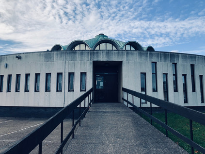
Fulwell Cross Library and Leisure Centre originated in the era of post-war reconstruction and civic recovery which produced much of the finest modern architecture in Britain. The scheme was proposed in 1958, with Frederick Gibberd - responsible for the sublime Liverpool Metropolitan Cathedral - commissioned to deliver the scheme in collaboration with the Borough Engineer, H.J Mulder. It took a decade for the plans to be realised, with the complex finally opening to the public in March 1968. Wedged into an awkward triangle of land where the busy High Street decanted traffic onto a churning traffic island, the circular library sat at the head of the peninsula. Beyond, the larger blocks of the leisure centre brooded over the construction, an empty civic square uneasily located between the two. The building was an arresting sight: like a landed spacecraft. The ramped entrance seemed forbidding at first. The ranks of tall, narrow arrow-slit like windows oscillated around the perimeter before stopping abruptly and entering a more uniform pattern which evoked either a bank vault or prison cells. Atop the whole structure, a copper-roofed lantern allowed light into the building below. I looked around: the people of Redbridge were going about their saturday morning, apparently oblivious to this strange imposition on their suburban landscape. They seemed utterly untroubled by its oddness and otherness, and clearly didn't want to borrow books today. I circled, making a complete trip around the library before retreating to attempt a picture which I knew the road would ruin. It was an exhilarating start to a trip which had seemed unlikely to deliver. Determined now to get walking, I set out eastwards along Forest Road.
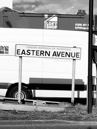
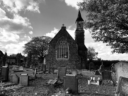
The suburban edges of London soon dwindled and the footpath strayed away from the busy road and into the trees. I passed under a wooden frame which acted as a ceremonial gateway to Fairlop Waters Country Park, and soon found myself surveying a broad, rippling lake busy with boaters. The view to the east was a rising plain of green with the dark smudge of Hainault Forest on the horizon. The suburban estates on this north-eastern edge of London were an irregular patchwork with the countryside of Essex intruding into them in sometimes unexpected ways. I plotted a course to the south of the lake, passing the impressive sailing club. A couple of members were enjoying an early beer outside in the winter sunshine, marking how late I was starting out on this walk. I had no real final objective in mind now - but I was determined to make the best of the fine weather. The path plunged into a thicket of woodland via a green avenue which disappeared downhill towards the valley of the Seven Kings Water. The autumnal foliage cast a golden filter on the sunlight and I found myself relaxing into the excursion. I'd realised over the last few weeks how much these walks mattered - and when one didn't go entirely to plan, how long it seemed until the next. The path curved a little west, then passed through a gate into the yard of the Aldborough Hall Equestrian Centre. A tiny dog yammered at me from a distance and then ran indoors. I began to doubt my right to be here, but it did appear to be marked on the map as a public right of way. I pressed on and escaped via the gate at the southern end of the site, unmolested by the little but loud mutt who's yelping continued somewhere on site. My plan here had been to turn east and head for the Seven Kings Water, but it appeared that Painters Road had no footpath and was regularly used by huge quarry trucks which filled its entire width. This wasn't a pleasant prospect, so I headed south along Aldborough Road instead. This country lane passed through pleasant farmland, the hedges being tended by hand-wielded sickle as I passed by. Beside the road, a Miller and Carter Steakhouse had occupied the former Dick Turpin pub, the name restored by popular demand despite the legend having little evidence to support a local connection with this most prolific of suburbanites. The village of Aldborough Hatch provided a gentle, drawn-out introduction to civilisation. Straggling along a straight road which gradually widened into a modern thoroughfare, it centred on the fine old parish church of St. Peter which glowered over the street from behind a haphazard graveyard of tumbling memorials. This was truly one of London's villages, tracing its name back to a hæcc or 'hatch gate' to Hainault Forest which stood nearby. The lands beyond the village were subject to dramatic and destructive deforestation in 1851 which saw trees uprooted overnight and the area cleared for farmland. This led, in part to campaigns which saved Epping Forest from a similar fate, but the farming here had never been easy or productive, and these long straight lanes laid out to access the land now provided a convenient high-speed rat-run for the stone trucks and BMW drivers. The backyards of the properties along Oaks Lane were littered with hints of the rural past: unserviceable farm equipment, listed outbuildings and remains of stables and farmyards - facilities which once served the now-demolished Victorian manor of Aldborough Hall. I was thoroughly enjoying the discovery of this curious village-within-a-city when the telltale hiss and drone of a major road began to overshadow the quiet of a suburban Saturday morning. I was approaching Eastern Avenue, where I'd planned to be a whole month ago. The spell of rural Essex was broken and I was back on my more usual turf. But this charmed zone is under a more permanent threat: as I headed towards the edge of Aldborough I spotted a sign on a lamppost - Brett Tarmac, the operators of the quarry intend to drive an access road through the nature reserve through which I'd just walked. The gravel quarry had won permission to extend even closer to the village, and the new road will carry the frequent, huge trucks to and from the site. It is remarkably hard to think that this quiet little nook on the edge of London being altered for generations. I noted down the link for the petition, determined to do my little bit though doubting it would change what seemed a done deal.
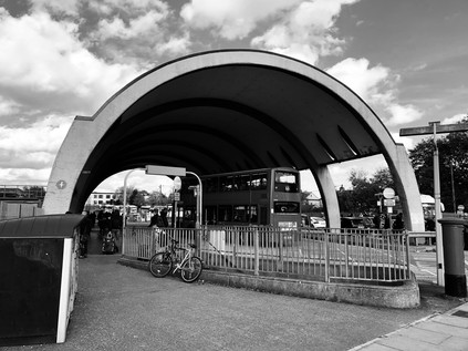
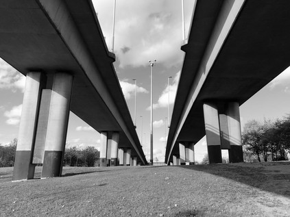
The flash of cars passing a high barrier designed to prevent pedestrians from dashing across the A12 heralded the end of Aldborough Road which decanted traffic abruptly onto the eastbound carriageway of the broad arterial route. Beside the junction, the fine jagged brick lines of the William Torbitt Primary School presented a proud face to the road. Named for the Borough of Ilford's then Director of Education, the school opened in 1937 and was designed in the art deco style by L.E.J Reynolds, the architect to the Education Committee. As my gateway to the road west, it was impressive and aspirational - modernised sympathetically so as not to alter its balanced and symmetrical face, the school echoed the municipal zeal of the interwar years. New roads and new schools to serve expanding suburbs. The optimism of the times was cemented into these good, solid buildings which ranged along this equally ambitious road. Eastern Avenue was planned in the great post-war road-building spree which saw Britain's network of ancient byways modernised and expanded to deal with the burgeoning ownership of motorcars. By 1924, the planners had settled on a sweeping modern arterial route to extend from Wanstead to Gallows Corner before taking the growing tide of holiday traffic east to Southend. The road was built to a remarkably high standard: a spacious dual-carriageway flanked by broad, separate cycleways which are now parts of the unusually generous pavement for much of the route's length. The modern A12 is a classic London arterial - running between suburban villas and parades of local shops and crossed via frequent pedestrian subways. For much of its length, Eastern Avenue is also remarkably fast-flowing, and in some stretches even falls occasionally quiet. The once pressing need to use this route out of the city has been superseded: the M11 takes traffic north into Essex and beyond, and the upgraded A13 provides a much swifter route along the Thames estuary. The mighty but groaningly overloaded M25 ferries a sluggish tide of traffic between these arms of the network while the A12 bisects the quadrant, now largely ignored except by local traffic to the suburbs. This also means it is largely unchanged from its original form, and as I began to plod west towards London, it was easy to ignore the modern developments along the route and to imagine the road as it would have been when new. I rather regretted I hadn't opted to cover the section from Gallows Corner to Aldborough when I'd last walked here, but perhaps it wouldn't have been quite so inspiring a prospect in the rain? My walk so far today had unfurled a spiral, winding out from Barkingside and now heading towards the Central Line again at Newbury Park station where I encountered another fine modern building. The bus station, built for the 1951 Festival of Britain still feels shockingly modern: a half-pipe of smooth, grey concrete with one of its elegant sides opened partially to the elements. Today, the rail closures at Liverpool Street made for lots of additional traffic as replacement bus services jostled for entrance with regular services. People milled around, unsettled by the changes to their expected journey and shaken from their usual sleepwalking journey into a weekend retail raid on town. I decided not to explore further: time was pressing, and the crush of slightly miserable, fractious travellers seemed like an unwelcome distraction. I admired the building from afar instead, trying and largely failing, to get a sensible angle for a picture. I was struck by the view through the bus station - the concrete tunnel amplified the bright blue sky beyond and the clatter and clamour of the boarding crowds. It was a fascinating and strange place which deserved another visit. Nearby, the Central Line passed under the road in a deep cutting. Once this line continued south to join the Great Eastern mainline at Seven Kings, but when the long-planned improvement works finally awoke from wartime slumbers in 1946, the tracks were slewed dramatically to the west to head into tunnels under Eastern Avenue. I peered over the bridge, briefly watching trains arrive and depart, before pressing on westwards to unravel the progress of the railway.
The horizon rose slightly as the road crested the shallow eastern lip of the Roding Valley. My route passed the austere and deserted Ilford War Memorial gardens which seemed to be curiously mislocated out here on the edge of the road. In fact, this was a matter of significant debate at the time of the gardens' creation in 1922, with locals seeing the site as "little more than a cabbage ground" but dignitaries assuring them that the coming of Eastern Avenue would create a great civic route into Ilford. At the extreme northeastern corner of the park, a tiny but imposing drumlike building housed the names of the dead. This Memorial Hall had followed the gardens creation in 1927, and was planned to form an entrance to the newly commissioned Emergency Wing of the Children's Hospital, though it was never used as such routinely. The symbolism was carefully balanced: from great sacrifice, new life. The hospital closed in 1993 when the modern King George Hospital opened nearby, and was finally demolished in 2001 with this tiny fragment saved for its ceremonial purpose. I stopped into a store attached to a nearby filling station and was admonished by the clerk for presenting the wrong loyalty card. I accepted his disgust as a blessing on my journey and set off again passing a ludicrously large McDonalds which I was certain must have a history. A little searching led me to The Green Gate, a pub with a long history on the site which still lends its name to this junction. Records of a beer shop here date back to 1861, but the sprawling brick building which has been appropriated by the golden arches of progress dates from a 1922 rebuild as a classic interwar roadhouse on the then-new arterial route. The internet was full of recollections of The Green Gate in its incarnation as a rock venue: the New Wave of British Heavy Metal had left a memory crater here on the fringe of Ilford which still drew a virtual crowd who had long since swapped their low-powered motorcycles for sensible family cars. Some pushed further back - Bill Haley & The Comets had played the Green Gate. Now, sticky fingers clamoured at the windows and when the door opened, the whoops and screams of over-stimulated and hyperglycaemic children pierced the drone of the road. In 2016, national newspapers had picked up the story of a late-night drive-through diner who had inexplicably Whatsapp'ed her transaction at the window, broadcasting an angry cursing employee to the world. The crossroads on these ancient routes are always sites of contention it seems. I thought of other old wayside inns I'd encountered which had suffered the same conversion: those around the North Circular in particular. It was hard to imagine Louis Macneice's autumnal progress along these routes in quite the same way when punctuated by regular calorie loading rather than flat halves of bitter, but I was glad the buildings still stood and had a modern use.
At Gants Hill, the road divided at a busy circus of local shops which concealed the Underground station. I descended into the complex of tiled subways, negotiating the junction largely by instinct as the signage was sparse and incomplete. Beyond the anonymous passageways and ticket barriers, the station is rather unique at platform level: modelled on the Moscow Metro with modern uplighters and fine tiling along the concourse between the platforms. Above ground, the A1400 struck out to the north - a spur of Eastern Avenue which carries traffic towards Woodford, and which was until the opening of the Barking Relief Road in the 1980s, part of the North Circular. It seemed fitting after my circumnavigation of those routes, to come to this historic terminal point. Today though my business lay on the A12, which lost even more traffic here, with the Woodford Spur offering easy access to the M11. I resurface on the southern side of the road, still a broad, high specification dual carriageway with pedestrian-proof barriers dividing the road - but now quieter. The view ahead opened out into the valleys of the Roding and the Lea. Pylons marched along the horizon, heading south towards the Thames. There was an autumnal haze over the landscape as I surveyed the territory I'd be walking. Eastern Avenue stretched ahead, descending gently with the terrain and reverting to type: red-brick mid-century semi-detached homes marched along the road, side roads into the suburbs largely unchanged except for a forest of satellite receivers and the imposition of 20mph speed limits. In the warm but weakening sunshine, it was possible to imagine the road as it had looked when build - wide, hopeful and expectantly stretching into a post-war future. A modern highway which extended the possibilities of a rapidly growing, modernising suburbia. It was still the age of municipal endeavour, and perhaps of paternalism in government. As the new road unrolled, so did the parks, schools and hospitals: buildings which seem so solid and inextinguishable, but which sometimes feel like they exist in only a flickering, tenuous way now. Eastern Avenue was a living, drivable museum piece. A walk into the period when war was over, perhaps forever. Where modernism was clean, sleek and decent. It was like gazing into the tubular station at Newbury Park and seeing the future.
Redbridge was a jolt to the senses - a jarring sense of familiarity coupled with a sensory hit of noise and fumes. I'd arrived at this vast circle of traffic from every direction except this one and while the location checked out, things felt inverted and confused. I took the wrong turning early on, heading under the road into a tidy subway tiled in the 1970s style and surfacing near the utilitarian brick tower of the Underground station. I retraced my steps under the road and finally found a familiar spot: a parting of ways where twice before I'd ascended steps to ghost the North Circular on its approach to Ilford. Today I continued under the next arm of the road, finally finding the centre of the circus beneath the two slender viaducts carrying the divided carriageways of the A406 overhead. The road was still descending from a crossing of the Roding nearby, and still reconstituting into a single route after dividing to admit access to the M11 back at Charlie Brown's. I finally surfaced near a small development of homes which I immediately recognised from inadvertently exploring this corner when attempting to track the river. I recalled being conspicuous and out-of-place here, and the sense-memory prickle of horror at being spotted as an alien swiftly returned. I'd not seen many walkers along my route today, but this next stretch promised to be the most forbidding and least well-trodden. Turning west again along the A12 I crossed the River near Wanstead Pumping Station. The forlorn edifice, approximately gothic in appearance, glowered behind well-secured gates while the tiny brick lodge nearby lay apparently derelict. It remained home to a collection of collapsing vehicles and a fat, grey cat which greeted me gratefully at the gates and tracked me until I crossed the water. Orienting myself by the flow of the Roding I spotted my previous route along the valley floor snaking away north and now, with experience and the boldness of familiarity, I could see the way I perhaps should have taken southwards between the golf course and the river meadows and cemeteries of Aldersbrook. The terrain here had become less alien with rewalking, and seemed to offer me an easier passage. I'd earned the right to walk here perhaps?
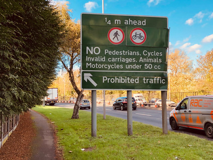
The road snaked into Wanstead, signs warning of my impending prohibition. The tunnels into which the A12 disappeared - perhaps a little less well-engineered than was optimal - were a concession to popular opinion. The route of the A12 from Redbridge to Leyton is an official compromise, an undoing of grand plans which would have seen a very different pattern of streets here had it succeeded. The original conception dates back to the post-war plans for swift but destructive Ringways: oft-mentioned here and now largely forgotten except by enthusiastic researchers of a London which might have been. This urban motorway scheme would have seen the M11 ploughing directly into London, crossing from the Roding Valley to the Lea and channelling into a complex junction at Hackney Wick. At the same time, the A12 would have been rendered largely pointless, likely downgraded from trunk route status and with its freight of traffic funnelled away by the new urban motorways. By the late 1980s ambitious road-building was back on the agenda with the publication of Roads for Prosperity, but the Ringway scheme was dead, a victim of a long struggle to convince the public that it would represent the optimistic progress of the times during which it was conceived. Instead, the M11 would terminate at Charlie Browns', and the North Circular would ferry traffic east and south onto the newly commissioned Barking Relief Road towards Essex and the Dartford Crossing. This left a problem - getting volumes of traffic from Charlie Brown's to Central London would have been the task of the extended M11 and the short stretch of the East Cross Route which had already been built from Hackney to the Blackwall Tunnel. An improved A12 would now bear this weight instead, built to Motorway standard and scything through the tired suburbs of Wanstead and Leytonstone, widening the unnatural valley already carved by the Central Line tracks. The protests had begun in the mid-1970s when the Ringways were still an aspiration. initially, the resistance was well-mannered and institutional, following - and exhausting - all of the usual official channels over a ten-year administrative process designed likely consciously to frustrate through attrition. By 1993 direct action had been successfully deployed by protestets to prevent road projects progressing elsewhere in the UK, and now voices from outside begun to be heard around Wanstead. Initially, their ecological and largely ideological causes seemed distinct from those of the locals who were now dog-tired and resigned to change. Eventually however, the actions of a local lollipop lady named Jean Gosling, would unite them and form a resistance which was both fierce and long-lasting. The protests centred on two specific sites, one of which was nearby: the footpath became narrower and less welcoming, with cars now uncomfortably close to my shoulder, while the noise and dust compromised any hope of sensing danger. Eventually I was forced to leave via a slip-road, while the road ploughed underground ahead of me. At the top of the rise I crossed the street onto George Green. It was here where the protestors had thought an early battle was won - the new road would tunnel under the green, leaving the wide expanse of quiet, green space at the head of Wanstead High Street. It had been here for centuries, a corner of Epping Forest which had survived as part of the grounds of Wanstead House. It seemed right it should lay undisturbed. However it soon emerged that the tunnel would be built by the cut-and-cover method, necessitating the destruction and replacement of the green, and removing many well-established trees. It was one of these, a sprawling and ancient Spanish Chestnut around which the protest coalesced. When Jean Gosling learned that the tree was threatened, she drummed up support among local children and parents. Ultimately, doing so in her official uniform saw her dismissed from her job. However, the views of the incoming protestors and the locals were aligning, and when campaigners arrived for a tree-dressing ceremony and found security fences blocking their path, both camps united to tear them down in act of resistance which harked back to the earlier days of Epping Forest. The campaign was ultimately defeated by a continued heavy police presence and many allegations of intimidation and violence against the contractors and the authorities. The cost of policing the protests to save the tree spiralled to around £500,000 and a national focus on the destructive path of the M11 Link Road was assured. The Green now was quiet, backlit by the sinking winter sun with the trees casting long shadows over the path of the buried road. A distinct and bleak strip of bleached grass described the path of the tunnel. Without the shade of trees, the long, hot summer had all but burned the grass away. The ghost of the road haunted the line of proud Victorian mansions and storefronts across the street. Wanstead is a prosperous, gentrified suburb now - and the years have been kinder to it than many other inner London zones. But the sense of a sleepy suburb comes to grief at the edge of George Green where the rumble of traffic still seeps from the ground, and no amount of pretence hides the imposition on the landscape which fumes and shudders below.
The road emerged from tunnel only briefly after passing under the Green before turning sharply and heading underground again, and there was no prospect of walking beside it. I crossed to the eastern side and followed a path which offered to take me to The Green Man. Through a metal gate, I caught a glimpse of the road below - traffic flashed by, dust churned and horns screamed as cars jostled for the correct lane at the upcoming junction. This wasn't the road I set out to walk, and any sense of loyalty to a plan or purposed had largely disappeared with the oddly dispiriting crossing of George Green. This section of the improved A12 is a 'special road' and pedestrians, horses, motorcycles and the like are consigned to other routes. I couldn't walk the route of the A12 even if I wanted to, and I'd need to take a diversion along other streets. I initially considered taking a route I'd walked before along Grove Green Road - but that didn't appeal. It would take me close to the other site of protest at Claremont Road but I had little stomach for more of the bitterness of lost campaigns today. I spotted the paths which I walked on my recent forest crossing which bisected the route of the road here and I was briefly tempted to return to Wanstead Flats. Instead I turned aside at The Green Man and headed into Leytonstone. This was, perhaps surprisingly, new territory for me. I've crossed Leytonstone's long, busy and diverse High Road many times - but this was my first opportunity to walk almost its entire length. Immediately after leaving the roundabout, a change registered. The smell of multiple cusines blended on the air: meat turned on charcoal grills while late fried breakfasts were served in traditional cafés to molify hungover stomachs, bitter coffee aromas rose over the curls of diesel smoke from delivery vehicles cocked with one wheel on the curb while fabric and 'phone cases were swiftly decanted into the long row of shops. Little had changed here in a century, but everything had changed too. The fabric of the street was the constant: shops below flats, railway bridges spanning the terraces. Meanwhile, whole populations had churned through Leytonstone, leaving their mark - and the traces of their culture - on the district. There was an air of quiet positivity here which didn't depend on any gentrifying action. While there were improvements in the pedestrian areas and much-needed places to sit and watch the world go by, there were no attempts to stage-manage the businesses. The mix of modern services, neat boutiques and older trades was dizzying and compelling. Walking the High Road was a surprising highlight of my day, and had a re-energising effect. I wanted to continue walking now - I had found my stride and beaten down the doubts and demons of my aborted mission last time.
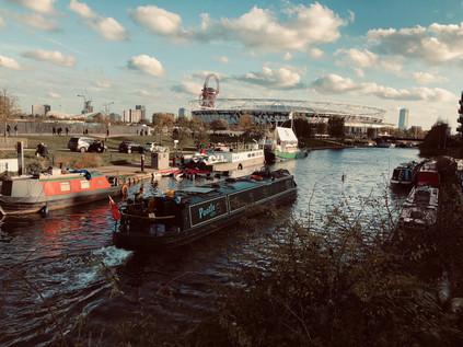
The sun was beginning to sink towards the horizon, throwing long shadows over the still busy streets of Leytonstone, and I realised I'd soon have to decide how to end my walk. It was tempting to just keep walking south, into Stratford and beyond - but practicality dictated that I start to head west at some point given the lack of transport options. At Crownfield Road I finally turned aside, heading back into the suburbs briefly. As I strode onward I found myself standing astride a small concrete marker on the footpath denoting the line of the Greenwich Meridian. Having one foot in each hemisphere felt appropriate - I was approaching the Olympic Park, a zone which felt distinctly different from the terrain I'd been crossing, and utterly alien to the East End of old. While the suburbs which splayed from Eastern Avenue were modern, aspirational and neatly zoned in their own way, they had little in common with the clumsily stage-managed new neighbourhoods which were now springing up in what was being dubbed Stratford City. I passed the entrace gates to Drapers' Fields and headed along Temple Mills Lane, crossing the complex of railway lines where Chobham Farm Junction would once have been located: the point that the Central Line had formerly joined the routes into Stratford. Despite the high security fencing and the forest of cranes sprouting from the ominously growing cores of future buildings ahead, this zone remained heavily anchored in its own history. Temple Mills was named for the large watermills owned by the Knights Templar and used, initially at least, to grind the corn grown on their extensive lands in Hackney Marsh and Leyton. This boggy, low-lying patch of the Lower Lea Valley has never been much inhabited, but has always served an ancilliary role: farming, grazing, milling. Later, the Great Eastern Railway located a carriage works on the site and the railways clung to a presence here until the very last moments before the Olympic storm settled on the East in 2012. Vast freight sidings being trimmed into a more modest wagon works and a locomotive repair depot, before finally becoming the home of off-duty Eurostar trains after their efforts on the continent each day. The other role of the vast, largely unused spaces of Hackney Marsh was storage: much could be kept out of sight here, things were easily lost on the marshes. During 1972, a strike at the Chobham Farm Container Depot saw five flying pickets jailed for contempt of court. The ensuing mishandled political fall-out contributed to the further decline of the already ailing Heath government. Tiny Temple Mills held the balance of the uneasy truce between labour and capital for just a short while. The government shouldn't have messed with Templar land: it suffered its own downfall, limping on into 1974 but dogged by industrial unrest and spiralling unemployment. Now the territory was quiet - a strip of brownfield land hugged the railway lines, waiting to be redeveloped into the new community of Chobham Manor. Beyond, the former Soviet-like blocks of the Olympic Village had been retrofitted to become homes, their lower floor retail opportunities mostly still vacant all these years later. The broad boulevards between the post-Olympic towers were in shadow in the late afternoon sun, young families arriving back from shopping or decked out in white robes, heading out to martial arts lessons. Large sections of the area still appeared unpeopled and vacant, dark windows peppering the upper floors. Ahead, the lights of the London Stadium glowed a pale blue over the tarmac. West Ham were playing at home, and as I headed deeper into the park and crossed the bridge onto the plaza surrounding the Stadium I began to feel like I was being carried along by a crowd of scarf-wearing fans. They were good-natured, perhaps friendly even - but I sensed they had me marked out as an interloper from the beginning. I peeled away towards the Lea Navigation as sirens howled and the Air Ambulance descended nearby in a swirl of dust from the compound beside of the stadium. The path around the Stadium running beside the Old River Lea was inaccessible today, so I made do with a walk along its sister canal - a veteran of so many of my walks here. It felt good to be back, crossing the bridge at White Post Lane and zig-zagging lazily onto Fish Island, dodging the oncoming tide of football fans as I fought my way south along broken pavements. Instinctively, I took a turn onto the Greenway. This meant doubling back on my route which had zig-zagged across the former marshes from Leytonstone - but that was no great hardship. I was on well-walked turf here. I knew my way.
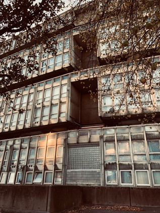
I headed back down to the towpath of the navigation where the Greenway passed overhead, its unsavoury cargo carried in huge iron pipes slung under the bridge. The taint of sewage hung cloyingly in the air, but it was good to be back on this path. This was sort of where it had begun: certainly where I'd begun to systematically edge further and further out of London. Where I'd realised that the vast, pale spread of the city on the map was a living, walkable thing. I'd resolved to walk it then - and at this natural point of reassessment I thought I'd made a pretty good job of covering the ground so far. There was, of course, ever a route untaken, always a turning unexplored. London was overwhelmed with stories, a complex mess of intersecting places which meant everything to somebody, but nothing to people just a street or two away. I picked up the pace - walking parallel to a golden sunset with the water beside me slowly darkening in the gloom. I passed under Bow Interchange on the cleverly designed floating towpath which bobbed slightly as I passed over. The path was quiet, the cold bright afternoon passing gradually towards twilight. I walked the familiar path feeling content and blessed by the opportunity. It was good to be back: passing Three Mills, crossing over the steep bridge at Bow Locks, ascending the slope beside the A12 to surface beside the Limehouse Cut. I was back on the road I'd set out alongside hours back in the comparative quiet of Aldborough. Here it was a grey gully of soot and dust. Gantry signs already vociferously diverted non-tunnel compliant traffic away from the final stretch of the A12. Or was it the A102 now? For a while this was urban motorway - one of the few segments of the Inner Ringway which ever clambered from the ambitious plans into reality. The Blackwall Tunnel Approach road clamoured and roared in a way which the A12 hadn't managed further east. It was the only way left to cross the river until the Woolwich Ferry. Drivers desperate not to be consigned to a long trip east or a diversion to Dartford bore down hard on the iron gauging rings which persuaded drivers of overlarge vehicles to think again before descending. Walking beside the road was a surprising education: the broad six-lane highway was flanked with dead businesses, defunct pubs, an abandoned Fire Station. The effect of the road out in Ilford had been cleansing and ambitious: new neighbourhoods springing from the uneasy interwar peace. Here though it was catastrophic. Blackwall and Bromley divided. Streets discontinued, and therefore ripe for future destruction. The soot-dusted trough in which the road sat was overshadowed by ill-conceived development. But then, among the glassy towers rose the concrete totem of Balfron Tower - wrapped in temporary cladding during works, only the lower rise neighbours at Carradale House reflecting the golden sunlight today. To the east, I passed the industrial edges of Aberfeldy Village. Grim and unreconstructed dead-end roads-to-knowehere disappeared among factory units, unlike the nearby development of solid and decent homes. It was almost a relief to see from the fly-tipping and junk tossed out of cab doors that some aspects of life here hadn't changed at all. The abandoned security cabins and tractor-units parked up for the weekend weren't giving away any secrets. I climbed towards the familiar intechange with the A13 behind a woman showing a newly arrived friend around the area: "There are shops up here, and a market. You can't want for much more here." The final few yards of my walk took me alongside the deep-channelled lanes of traffic which led to the Blackwall Tunnel. My attention was focused downwards, keen to glimpse the moment of transition: when cars were wholly underground. A magical disappearing act. So studious was my subterranean focus that I was shocked to look up at a still extant section of Robin Hood Gardens. The tattered edge of the stately but still curiously elegant concrete block, with some end-flats cruelly exposed to the elements, flapping in the breeze from the Thames. Just one flank remained of the vast horseshoe shaped development which had once seemed so futuristic - even perhaps hopeful? The fight for its salvation and restoration was largely orchestrated by architects and urban planning enthusiasts, and was set against a keen voice for demolition from the final residents of the complex. They had witnessed it's ultimate downfall - and heralded the loss of the one realised opportunity for Alison & Peter Smithson's 'streets in the sky' to change urban life. Robin Hood Gardens wasn't a faulty building in every sense, but it had been left to decay under the broken municipal contract. Overall though, the ambivalent voices of the debate had been tamer than the fury in Leytonstone, and both had merit. The only reprieve would be a section saved for display at the V&A - perhaps the ultimate gentrification project?
I slowly wandered over to the familiar bus circle at Blackwall, tired feed beginning to glow with the memory of a road well walked. So this was progress? I wondered as I left Robin Hood Gardens, the concrete tinted a warm pink and windows winking in the sunset, if the guardians of civic pride in little Aldborough would have thought the same?
You can find lots of pictures from the walk here. The M11 Link Road protests are extensively covered in sections of Will Ashon's 'Strange Labyrinth' (Granta, 2017) and in poetry and photography in Paul Hawkins' 'Place, Waste, Dissent' (Influx Press, 2015)
Lost::MikeGTN
I've had a home on the web for more years than I care to remember, and a few kind souls persuade me it's worth persisting with keeping it updated. This current incarnation of the site is centred around the blog posts which began back in 1999 as 'the daylog' and continued through my travels and tribulations during the following years.
I don't get out and about nearly as much these days, but I do try to record significant events and trips for posterity. You may also have arrived here by following the trail to my former music blog Songs Heard On Fast Trains. That content is preserved here too.
