It felt like a quite a while since I'd walked beside water...
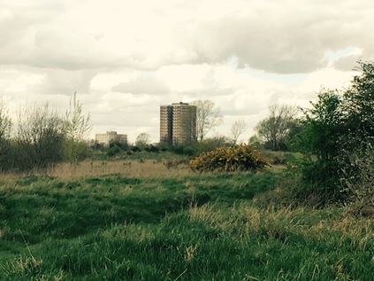
My journey to London had been sleepy and distracted. Relaxing didn't come easy this morning after a long and trying week, but as I made progress towards the start of my walk, I began to feel a little more alert. The routine was familiar from my attempts to walk the fringes of London: over to Liverpool Street, out to the suburbs, then a bus to the start of my walk - which had seemed to grow increasingly further from civilisation over the months of walking rivers. As I careered around the roadworks outside Romford Station to reach the stop where I'd depart for Collier Row, I realised I'd be passing this very spot later if all went to plan. Even the name Collier Row sounded distinctly unlike London - a strangely northern sounding area, which was in fact a fairly modern nod to ancient charcoal workings near the site. In truth I was feeling a little range anxiety - heading to the very end of the bus routes, to the curious spots on far-flung estates where engines idle and the drivers pull out their newspapers to lay-over until the next service back to town. In the event, I hopped off a stop early - the bus was cresting a rather steep hill which promised a view across the surrounding area, and I didn't want to miss the opportunity to survey the landscape. I was the last passenger off, standing on a dusty corner near a row of bungalows and struggling with my rucksack while the bus trundled away to its terminus. The penultimate passenger shuffled away with her shopping, casting a suspicious glance back at me. I was alone at the top of the hill. Away to the north the low hills of Essex were fringed with woodland. The suburban sprawl simply stopped at the end of the road. A row of off-duty buses lined the narrow street, giving it an air of far more importance than it deserved. To the east and west, the ground rose to envelop this northern extremity of the city. It was time to start walking...
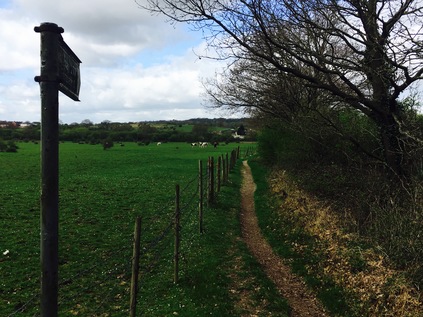
The continuation of the route down the hill became Clockhouse Lane, a mettled track leading to some decidedly unofficial looking dwellings. The yards were littered with vehicles in varying states of repair, and a vastly over-engineered set of ornate but clearly sturdy metal gates blocked the route into the back garden. What it secured, I dared not consider. Beside these houses, a row of industrial premises and breakers' yards filled in the edge of the woodland. In contrast, horses grazed on the other side of the track, lazily wandering around the grassland with only a vague interest in me, the solitary walker in this oddly unpeopled landscape. No-one moved inside the sheds and garages, despite a distant radio playing. I reached a junction where muddy tracks led off in several directions into Havering Country Park. This remnant of land once annexed to a royal palace and deer park isn't simply an urban oasis - it's the start of the countryside in earnest. The park stretched away east and north - but my route led a little west here to my first contact with the River Rom, already a strong and substantial stream having made its way south from the M25 as the Bourne Brook, to reach the edge of the suburbs here. The horseshoe-rutted path opened into a country lane which crossed the river at a low bridge with a parapet on its southern side. The other side of the lane fell away steeply into the water beneath, a curious eroded cliff at the edge of the road surface. Horses were being carefully walked towards me from a stable up ahead, heading for the paddock I'd passed beside. I turned south, heading down Carter's Drive which ran broadly alongside the Rom, and lead me back into the sprawling Havering Park estate, a low-rise interwar development which snaked south towards Romford. One of the reasons I'd put off this walk for quite some time was a concern that I'd largely be consigned to walking the urban byways which fringed its route. But at Firbank Road where buses crossed the river on a low metal-railed bridge, I was surprised to find a gate giving access directly onto the river bank. With a freshly mown stripe in the riparian foliage, I was amazed to be able to walk alongside the river in the unexpectedly bright morning sunshine. With a solitary dog walker well behind me, I was soon alone in this quiet green channel which ran unseen between the back gardens of Havering Park. The path followed the Rom's gentle curve towards the west, continuing for some distance and making for a pleasant and peaceful tramp. It was crossed by a small bridge at the oddly named Bacon Link before running into Collier Row Recreation Ground, a small triangle of green space crossed by well-kept paths and dotted with play equipment. A path led me out of the park, still beside the river to Collier Row Road, a busy thoroughfare which linked the wide sweep of housing with the surprisingly bustling centre of the district to the south which my bus had passed through earlier. At this end of the road however, on the very edge of the urban sprawl, there was little aside from an Esso service station. I stocked up on provisions, crossing the road near a concrete bridge over the river which finally gave formal acknowledgement to the River Rom on small nameplates.
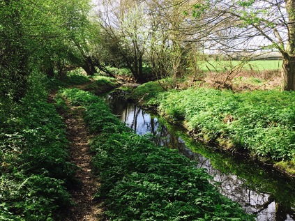
I had to navigate around some obstacles here, heading along White Hart Lane to progress south. A little way along the road, which I'd assumed I'd be following for some distance, I spotted a signpost for 'Footpath 19'. Havering is well-served by a network of public paths and follows the generally excellent sign-posting practices of neighbouring Essex. I knew this path would cross the river so I decided to make a minor diversion to take a look. After a stroll along the edge of a grassy area of scrubland, I found the river bridged by a substantial structure topped by a stile. Beside the bridge though was a tantalisingly well-worn path reached by way of a concrete access ramp, usually reserved for the Environment Agency. In this case, it led down to a well-worn groove in the grassy bank which clung to the meandering course of the river. I couldn't resist a look, and there was at least a possibility it could lead me further on my route. I was soon enveloped by a canopy of trees, the river burbling beside me as I trudged a line no wider than my feet between clumps of fern and nettle. If I'd tried this even a few weeks hence, these nettles would have been impassably tall and overgrown - but for now I could trudge safely between them. The path, unsanctioned but clearly not policed, continued - and I reasoned that for a route to be this well-worn for such a long distance, it must lead somewhere. If not it would be a long walk back to Footpath 19.
After turning a little to the east, the path ended at a rough scramble up a bank. Out of the trees, this grassy berm was in fact the fringe of a field of waste ground given over to flood prevention. The river curved around the southern edge, heading back towards civilisation, while I took a shorter route across the northern fringe. The path appeared to deposit me back on White Hart Lane, but first I had to navigate a stile where a surly and disinterested local youth was perched. I walked until I was mere inches away, with him surveying me as if trying to asses my chance of making it over the gate with him still in situ. I breezily excused myself and he moved aside, barely breaking eye-contact with his 'phone while I swung over and let myself down in a clumsy sort of two-footed jump. It was a heavy landing, but I wouldn't dare give it away. Suppressing the grunt of effort and discomfort, I emitted a curt "Thanks, pal" before striding off between the buildings onto White Hart Lane. I was beside a row of quiet shops in now remarkably warm spring sunshine. I pressed on, detouring briefly into Cross Road to see the river passing under the street, and to confirm there was no easy way to shadow it here. Proved correct, I returned to Mawney Road which continued the route of White Hart Lane towards Romford. A little way along the dusty pavement, a few yards beyond the point where the Rom passed beneath, I spotted the entrance to King George's Playing Fields. The path soon rejoined the river in the busy park and, almost uniquely among these unloved tributaries, I saw people using the river. Children swung above the water on a ubiquitous blue rope, or tottered over makeshift stepping stones in the shallow brook while parents stood by and encouraged them to explore. It was a surprising and rather touching thing to find out here where I'd seen virtually no-one all morning. I lingered for a while, enjoying the sunshine and watching people come and go along the riverside path, often somewhat oblivious to the hardy little stream flowing so close by. Feeling some of the tense cramp which had followed the impact of my leap from the stile beginning to disappear, I set off out of the park passing a busy café doing good business, and directly onto the thunder and dust of the A12. This wide dual-carriageway, divided by a centre fence to deter crossing except at designated points, scythes across the north of Romford. I turned east to cross the road at a surprisingly well-kept subway with impeccably clean 1960s tiling still intact, displaying long-forgotten scenes of local history. Emerging south of the shrieking lines of traffic which powered through the busy urban crossroads, I was entering Romford. The old pattern of streets from before the coming of the A12 was evident in the names of roads which continued into town despite being severed by the canyon of traffic. A sign beside the rather fine modern Bus Garage welcomed me to the 'historic market town'. I was a little dubious about this welcome just now - and the river felt further away than ever as it gurgled between gardens and yards, inaccessible and about to delver under this modern Town Centre.
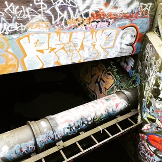
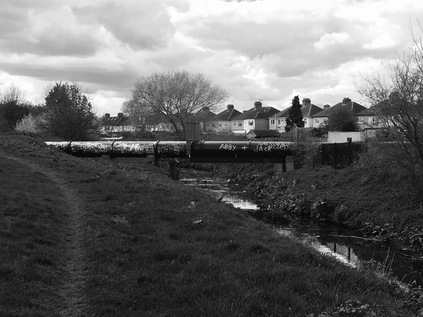
As it goes, the traversal of Romford wasn't quite as bad as I expected. Despite the rather forlorn aspect of the view along North Street into the bowels of a part-refurbished concrete office block, and the straggling edge-of-town feeling with the omnipresent low-rent restaurants, poundshops and cheque cashing establishments. There was in fact a surprising feeling of life to the town. The busy pedestrianised core of the town centred on a cluster of market stalls which felt like they had always been here, the new developments fringing the town in a ring slowly enveloping them but oddly not driving them away. As I passed under the railway I found myself back at the spot where I'd set out by bus. The dry, dusty pavement was interrupted roadworks while a constant queue of double-deckers crawled up to the footpath and then slunk off under the bridge. Coming full circle felt strange and a little unwelcome. Nevertheless, I pressed on - and Romford reverted to type, the shopping street petering out into a mess of housing and light industry as North Road became South Road. Somewhere beneath was the River Rom, appearing briefly in a graffiti-covered culvert before ducking under the impeccably sculpted grounds of the Queen's Hospital, the gleamingly modern and undeniable evidence of a PFI deal gone bad. The only way the premiums on this site could be paid would be by ceasing delivery of healthcare completely. It was a brick and concrete emblem of the impossible bind the NHS finds itself in worryingly often. I crossed the A125 via the complex web of lights and crossings at Roneo Corner, named for the former Roneo-Vickers office equipment factory which dominated the geography and employment prospects of people in Romford for generations. By the mid 1980s the workforce here had dwindled, with only postal franking machines still assembled on site and most of the reprographic equipment imported directly from Japan and distributed from the Romford site. Like so many of these areas of London's suburbs where a particular activity is burned into the soil through long association, the name lives on. Even now, around two decades after the factory closed its doors the Roneo Cafe and Roneo Prestige Motors trade in the tired range of local shops along the main road.
The river is an equally persistent force here, finally free of the concrete channel which has contained its flow under the town centre, it curves broadly to form the edge of Grenfell Park. I enter via a neat new cast iron gateway and find the park is a wide, empty field of grass with a fenced play area occupied by a languid and bored group of young men who are distinctly too old for the equipment. There's little else to be seen - certainly nowhere else to sit or pass the time. I sense I'm being followed by the group's eyes, but that they're just too inert and passive to do more. I'm a curiosity - a moving thing in a still landscape. A roughly walked path hugs the river on the western side, passing under the shadow of the hulking YMCA Thames Gateway building. This facility occupies a purpose-built mid-60s tower block of the type which would have doubtless have fallen into disrepair or worse had it been left to the borough to run. Instead, the YMCA is doing fine work here. There are addiction recovery services, emergency housing, a gym, a diner and family support work alongside a 148 bed hostel. Most of the site's facilities are open to the public too, connecting the building with the town. When I passed by the site was busy with a children's party is in full swing, and the building - although an ominous landmark on an otherwise low-rise skyline - felt like a positive presence in the area. The character of the park however was harder to discern and unsettlingly it seemed to have no clear boundaries. For the first time today, I felt myself checking over my shoulder as I delved between trees and onto another rough track which lead me back to the river. Once again, I was alone - this time on a narrow path which tracked the surprisingly deep valley carved by the Rom's meandering below. It was comfortably cool and quiet, and I relaxed into my earlier thought that only a path which actually went somewhere could be so obviously well walked. The ever-present scattering of discarded clothing and lager cans in regularly spaced, burned-out middens meant this was a well-used way. I wondered at the thought of flying low over this area at night, spotting little flickers of fire in the dark areas between well-lit streets. The river here is the boundary between the Boroughs of Barking & Dagenham to the west and Havering to the east - and the character of these suburbs feels different to those to the north of Romford. Despite being built to relieve pressing housing need in the same interwar period as Collier Row and Harold Hill, there is a more downtrodden, working-class feel to these areas. Perhaps it's the greater proximity to the long-closed docks and the few remaining pockets of industry clinging to the Thames estuary, or just the slow shift of a traditionally-minded population east from the edges of the city - but there is a sense that this zone is trapped in the last days of Empire. It's perhaps no coincidence that secret BNP meetings were held in nearby Elm Park, or that the idiosyncratic Richard Barnbrook could be elected as a London Assembly member for Barking by way of invented tales of knife crime and jingoistic outpourings. Deep in the river valley, walking the boundary of the boroughs, I felt separated from this world of distrust and discontent as I crossed a minor and seemingly unnamed tributary of the Rom arriving from the east. To the west of the river a sizeable area of common land opened up, part of the chain of greenbelt which sweeps south from where my walk had begun, almost unbroken until it reaches the marshes near the Thames. I found this unsettling - perhaps I should have crossed the river sooner and this path would indeed lead to a dead-end? I decided to scramble up the bank when an opportunity presented itself - and was relieved to see a couple of motorcyclists in hi-vis paused on a narrow street. I was about to crash out of the bushes to survey the landscape further when I saw a similar group pottering along behind them - this was a driving school! The pattern of tiny roads and roundabouts was an elaborate fake for the purposes of teaching the rules of the road in comparative safety. A small hatchback with a terrified teenager at the wheel lurched and shuddered along the road behind the motorcyclists, while I scrambled back down the bank onto the riverside path.
A little further on I found another path leading up the bank to a narrow lane, which I had to take as the river passed under a low bridge here. The Chase felt like a typical country lane despite connecting two distinctly built-up suburbs, passing through a nature reserve in the process. The road was surprisingly busy, and I was forced to remember my Country Code to stay safe from the traffic - a surprising twist to an urban ramble near Hornchurch. I looked for a way onwards into the fields, but couldn't obviously see a route near the river. I was aware that any detour to the west would involve finding my way to a footbridge over the railway which didn't look easy to access from the map, so I hedged my bets and turned east to Upper Rainham Road. This meant a detour along a busy road at the edge of the nature reserve, but at least stayed close to the course of the river. I paused for lunch and rested for a while near the entrance to Harrow Lodge Park, aware that the Ravensbourne passed underneath here on its journey to meet the Rom a little way to the west. This also marked a point of transition - where the River Rom becomes the Beam River. I walked on under the railway, to a sharp bend in the road where a footpath turned west and ran along the perimeter of the Borough council's Works Department. I followed the path and was soon rewarded with a broad southern view across a plain of scrubland. Along the line of the railway I could see the battered footbridge with trains slowing for Elm Park as they passed under it, and rather incongruously the fine 18th century Bretons Manor House looking across the shallow valley towards the line. Now part of the borough-run Outdoor Centre, the manor traces its origins back to the Breton family occupying land in Hornchurch in the 12th century. Now it provides sports, archery, kite flying, nature walks and the like to young people locally. Turning towards the river, I found a recently opened bridge provided access to the other bank, allowing me to stay close to the Beam as it skirted a long, narrow lake at the bottom of its valley. The well-made paths on this bank were apparently well-used by dog walkers and cyclists, winding through the marshy bottom of the Beam Valley. As I approached the exit onto Rainham Road South, I foolishly stepped off the path to avoid a large puddle and found myself ankle deep in marshy, red Essex mud. No surprise that the local family who I'd seen entering the park on their bikes had taken a wide detour around this section. My boots now a shade of terracotta, I edged out of the gate and crossed the street to approach the last leg of my walk.
South of Rainham Road, the green area around the Beam has recently been designated a new park. The site was, until the 1990s occupied by the derelict remains of Dagenham Sanatorium. Built on the site of Rookery Farm following a 1894 smallpox epidemic, the somewhat makeshift facility became a TB hospital, before eventually specialising as a geriatric care unit. Closed in 1989, the site slowly returned to nature and is now barely discernible on the ground. Beside the park, east of the Beam River was Mardyke Farm. No sign of a farm now - it having long been replaced by a chain of sand and gravel pits, latterly used as a landfill site, which is now being remediated to accommodate new housing. There is an inkling of the Thames on the horizon as I walk south - the huge wind turbines and water towers of Ford's works are evident on the horizon, along with the flicker of traffic passing along the elevated A13. The river is a deep, straight canal here, receiving flood water and protecting the low-lying land around it. As I cross the incoming Wantz Stream and clambered up the bank beside the sluice which protects the river, I had an unobstructed view south to the industrial wastelands between here and the Thames. I realised with some surprise, that this was one of the riverine walks where I'd stayed truest to the course of my subject - and that I'd rarely strayed from the Rom or the Beam along the whole route so far. But I'd suspected the gate onto the A1306 would be closed and locked just like when I'd passed once before - and despite the official notices stating this was an access to the Beam Parklands, it was unsurprisingly impassable. I thought about climbing the gate, but reconsidered after recalling my incident with the stile earlier. Instead I returned to the sluice and headed a little way along the Wantz Stream atop a high flood-protection bank which fringed the parkland and curved around the oval of a busy housing estate. I trudged through the estate, tired and footsore to find a bus stop on New Road - which is of course now the older route of the A13. As I waited for the infrequent service back to Barking Station I thought with some regret about the section of river I couldn't access: the arrow-straight course it took under this very road, between the remaining parts of the Ford plant, under the A13 and beside the mysterious Dagenham Breach - famous for its parliamentary whitebait suppers of old. My attempted walks in this zone - along the Thames foreshore, or the A13 - had never quite reached the end of the Beam River. Only taking a train or the recent passage by car had even come close. There was an inconclusive, agitated feeling of not quite getting the job done once again, which somewhat typifies my feeling in this part of the world as I cross and recross it. That said, my aching feet and slightly sun-pink forehead were evidence that I'd walked as far as I could. Some mysterious rivers are destined to stay that way it seems. I started my bus journey back west, unravelling the route of another old walk as I went, and realising I knew the way surprisingly well now.
You can find a gallery of images from the walk here.
Lost::MikeGTN
I've had a home on the web for more years than I care to remember, and a few kind souls persuade me it's worth persisting with keeping it updated. This current incarnation of the site is centred around the blog posts which began back in 1999 as 'the daylog' and continued through my travels and tribulations during the following years.
I don't get out and about nearly as much these days, but I do try to record significant events and trips for posterity. You may also have arrived here by following the trail to my former music blog Songs Heard On Fast Trains. That content is preserved here too.
