I'd worried all week about whether my new winter coat would arrive in time for this walk. Commuting to work in sub-zero temperatures during the past week had alerted me to the simple fact that I was ill-equipped for a December jaunt, reminding me of the cruel winds which whipped around me as I strode out into Essex at the end of last year. I'd half-heartedly planned several potential walks - and I was prepared to change my plans and have a day of train-related travels if the weather turned ugly. However, the coat arrived and as I rather snugly skittered out of Liverpool Street on a local train, I realised that a decent pair of sunglasses might have been a more pressing purchase for today. As we snaked across onto the fast lines and sped out towards the east, the low winter sun glared into the windows, glinting from the cranes which surrounded the edges of the Olympic Park at Stratford and throwing long shadows from the half-built towers of East Village. It was a relief to be moving - the last few weeks had been challenging and felt like a hard slog at work for both of us, and the chance to get pavement under my boots again was welcome. The half-formed plan which I'd settled on was to return to a place I'd formed a perhaps unfairly poor impression of to start my walk: Chadwell Heath. I was on the trail of the Mayes Brook: a tiny waterway which rose hereabouts and meandered south and west towards the River Roding at Barking, forming along its course the perimeter of one of the most significant public housing schemes ever built and providing a boundary between boroughs for a good deal of its length. I'd crossed the tiny but significant brook on my A13 walks, found it interesting and wanted to explore further. That walk though had a clear purpose, so I had to content myself with laying down a marker for future travels. It was curious how these furthest eastern expanses of London, which had seemed both a formless suburban sprawl and an almost troublingly dark place at first, were now filled with these streams and byways which I felt an urge to understand. I felt like I was slowly coming to know the territory, pieces slipping into place as streets were crossed and re-crossed, the edge of my ever present range anxiety slowly pushed back towards the coast of Essex.
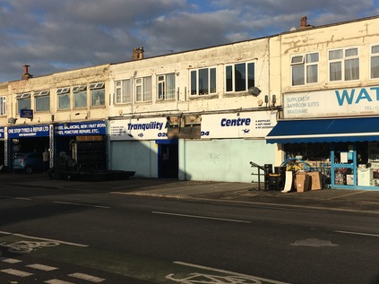
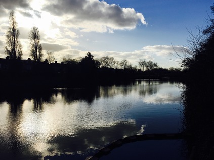
My return to Chadwell Heath did a little to soften my previous opinion. On a bright winter morning, the walk down from the station to the long straight High Road to Ilford was pleasant, and while the street was still a collection of enterprises barely hanging on in their crumbling mid-century parades, it was a least a little more cheery. On the corner where I joined the main road, the imposing 1934-built Embassy Cinema building had become the unspecific 'Mayfair Venue' - apparently a banqueting suite in a somewhat unlikely spot. Across the street, the urban centre petered out into a long run of domestic appliance repair centres, used car lots and the apparently ill-starred 'Tranquility Centre' - formerly a tropical fish emporium. My target was an unpromising alley beside a petrol station which led to a bridge over the rails I'd just travelled. As I reached the top of the bridge the sun crested the low roofline of the houses and the scene was surprisingly illuminated from the south. Shielding my eyes I picked my way along the path leading to Green Lane and the entrance to Goodmayes Park. The park opened out into a broad sweep of green with a glassy black lake stretching along its eastern side. Through a broad refuse trap, and behind a boom restricting pollution from entering the carefully cleaned up lakes, the Mayes Brook trickled in from its source. The park was quiet, with a few distant joggers and dog walkers crossing the bridge which separated the upper and lower parts of the long lake. Straying from the path I took the well-worn gravel track which edged along the water, and from the southern tip of the lake I looked back at where the brook entered the lake. So little of the short waterway is above ground, making these occasional glimpses precious. Turning south again I headed out of the park by crossing Mayesbrook Road - one of the few nods to the presence of the stream here. Looking east, the uniform houses marching into the distance marked the western edge of Becontree - when completed in 1935 the biggest municipal housing development in the world. Straddling the Boroughs of Ilford, Barking and then remarkably rural Dagenham, the estate was extended twice before finally being fully absorbed into the new borough of Barking and Dagenham. From the air, the streets fall into regular patterns of straight crosses and fans of stacked crescents. The rails that once ran along Vallance Avenue to carry building supplies the estate are long gone, and the vast estate now relies on the spreading arms of the Great Eastern Railway and the District Line which it sits squarely between. Crossing another street I enter the unimaginiatively named Goodmayes Park Extension - a broad sweep of close-cropped grass divided into football pitches, with an allotment on the western flank. The path edges around the pitches, skirting around a range of pavillions and changing rooms painted a drab municipal green with windows fully boarded up. Somewhere under here, the brook runs south and west, towards Goodmayes Lane. Above the tree line a formal facade and clocktower indicate the site of South East Essex Technical College - latterly the University of East London. Built to provide education for the new population of Becontree who were inconveniently split across three Local Education Authorities, the campus survived until 2006 when UEL rationalised its estates and these imposing buildings were redeveloped as housing. The main block is named Mayesbrook Manor - the water, it seems, is never very far from the surface.
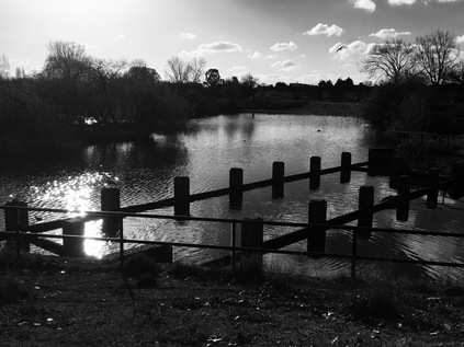
It's only a brief escape from parkland - long enough to navigate the junction of the busy and broad A124. I find a small corner store here and buy water. In my urge to get moving today I've neglected the usual preparations, and the walk so far has been surprisingly warm. Across the street I see a tell-tale patch of reeds behind green railings. Looking down from the street Mayes Brook trickles slowly between carefully reinstated habitat, a wild thatch of grasses beside it waving in the breeze. Beside the nature reserve a grand gateway opens onto a broad pavement leading into Mayesbrook Park. The line of green space which runs along the course of the brook - whether present above ground or not - is almost unbroken, and I'm soon walking a broad grassy trail close beside the stream which flanks Barking Football Club's home ground. A vast modern sports facility fills almost the entire width of the northern part of the park and through the trees and fences I spy a lurid purple splash with a familiar angular font - this is another London 2012 legacy artefact. That said, the sports centre appears well-used this morning, and the ranks of football pitches which spread south into the park are equally busy with games formal and otherwise. I stick to the western fringe of the park where the brook curves through new drainage swales and wetlands, created to cope with the ever-troublesome waters of the brook in flood, an event anticipated to be more frequent and dramatic as the earth warms. An arm of the brook passes under a squat bridge with a low brick parapet, draining into the broad lake which fills a former gravel pit. These pits were originally separated by a long narrow causeway leading to a broad circle for turning the plant which dug and carried gravel - this is reputed to have given the park its local name: Matchstick Island. The park was planned on a grand scale - its sporting facilities matched by sunken lotus gardens and stepped verandas. The newly transplanted inhabitants of the Becontree and Leftley Estates would enjoy the fruits of inter-war municipalism until the 1980s when a lack of repair and vandalism led the Borough to remove the sunken gardens. The lakes remain, with the carefully planned wetland course of the brook curving around them to exit the park under the District Line. I lingered in the park for a while watching Canada Geese massing on the wide concrete slipway into the lake. I could have hung around longer too - It was a perfect morning to be out here, and there was an uncertain distance to go - so reluctantly I pressed on out of the park into a place which doesn't exist...
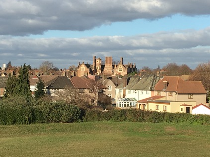
Railway station names are not nearly as fixed and unchanging as they might sometimes seem. In London most especially, the plethora of competing companies operating independent lines prior to nationalisation made for a confusion of names - often similar though relatively distant - in order to attract the lucrative commuters who sought a haven away from the city. Sometimes multiple stations co-existed confusingly with the same moniker - the multiple West Hampsteads which straddle the road north from Kilburn even today for example. As the fortunes of suburbs fall and rise and fall again, their stations names are extended or curtailed according to popularity and reputation. Equally, as the railways struck out into undeveloped territory during the Victorian and Edwardian building booms, the stations took on the names of wayside inns, manor houses and hamlets which have long since been swallowed by the ever-encroaching edges of the city. In this way there are many suburbs and districts of London which have grown around and subsequently adopted the name of their nearest railway station. But I realised as I stood outside Upney Station that there really isn't an Upney at all. The station is an unremarkble low-rise brick building straddling a road bridge in the style of many at this end of the District Line. Atop the building a spike pierces a large Underground roundel, the bridge extending beyond the building to cross the mainlines to Southend. I was now walking along Upney Lane - in traditional British nomenclature the road to Upney - and on the tiny parade of shops at the edge of the estate was an Upney Fish Bar - but that was the only hint of the name on the ground. On my OS map, and even on Google's map which is often tainted with unofficial user contributions, the area had no specific identity. It was a hinterland of Barking - or perhaps a premonition of Dagenham depending on your viewpoint. But it wasn't Upney anywhere. My stay in this ghost suburb was brief - but for good reason. Across the bridge, and just a few steps to the west was Eastbury Manor House. The house can't easily be seen from the north or east due to a rise in the land - and it seemed unlikely that I was approaching a survivor of Elizabeth I's reign as I tramped around the carefully laid out quadrant of an inter-war housing estate. The quiet streets were full of the smells of lunchtime cooking and still-ticking off-duty cabs. But suddenly the square opened out and beyond the wintery frame of empty branches, a tall brick manor house stood in contrast to the municipal housing around it. Now managed by the National Trust, Eastbury was built on high land which provided fine views across open country to London and the Thames by Clement Sysely probably around 1570. Its situation now is changed - but the sense of being at a high point remained as I walked the boundaries of the square of land in which the house sits. The tall ranks of chimneys and the surviving octagonal turret towered over the pleasant little council houses ranged around it - and it seemed an unlikely survivor. When housing was scarce and the modernising spirit strong, so many places of interest were bulldozed in the name of progress. But somehow, at Eastbury, the wonderful hall has survived as a museum and venue, open to the public at times. The name survives too in the Council Ward of Eastbury - and perhaps in truth that's why Upney never caught hold here? The ancient manor has prevailed in more ways than one.
I emerged from the deleted suburb of Upney at Ripple Road, where the old course of the A13 turns south east to head for Dagenham. The Mayes Brook surfaces again from beneath the gloomy slab block of Sebastian Court, passing under the road and emerging beside a wide strip of well-walked grass. An Environment Agency gate prevents vehicle access, but appears to allow pedestrians to walk alongside the brook here. The sun was bright and low now, and it was difficult to see far ahead - and near impossible to take photographs. I spied someone standing near a bush up ahead and trod carefully - the edges of the grassy path were strewn with the usual edgeland litter - the ubiquitous Polish lager cans, blue convenience store carrier bags, blackened fire-circles. As it turned out, two dog walkers were conversing on opposite sides of a mound of brambles. One of them moved on passing me by, while the other, a while haired older man with a muscular and enthusiastic Staffordshire Bull Terrier, hailed me: "I'm letting him off the lead. OK?". I replied that I wasn't with a dog, but I suspect my unease was still evident from my voice. He told me not to worry - he was a good lad, and just happy to get a run. There weren't many places in easy range for a good run, not which an 82 year old could get to anyway. I strolled along the edge of the brook chatting with this unlikely companion, the water trickling quietly beside us and almost eclipsed by the growing screech of the unseen but nearby A13. He had lived here on Ripple Road for over 40 years, and in Barking for almost his whole life. He'd leave if he could - but he felt he was too old for the stress of upheaval. Certainly, he envied me living in Somerset: "By the sea, eh? Lovely". Much had changed here, he thought - but lots stayed the same. It had always been tough - always a challenge to get on. The Asians earned his grudging respect - buying their properties and extending them, letting out rooms, moving out into Essex on the back of their investments. He didn't dislike them but he didn't trust them or the changes their now overlarge houses made to the area. The new wave of immigration from Eastern Europe troubled him more - the litter, the ruined green spaces, the lack of any sense of integration all worried him. He'd clashed with the young men throwing needles and leaving torn cans in the grass and they'd been rude and abusive - he thought the muscular, moderately wild-eyed but basically docile creature he led along the brook had saved him from trouble more than once. His quiet intolerance was fiercely practical - not motivated by politics at all. While it felt odd and discordant to be speaking in these terms so alien to my own view, he was clear that no political party had it right. The working class parties couldn't talk immigration without tangling themselves in guilt, and UKIP felt like Mosley's bully boys who were still an East End folk memory for his generation. We found ourselves at a steel palisade fence which fully blocked access into a broad green field bordered by the brook, the railway and the concrete viaduct carrying the A13 above them both. I didn't expect to get beyond the railway - but I'd hoped to get closer to the bridge. My companion told me that this had been installed after a group of travellers had parked on the field. The Environment Agency had sequestered the land after an expensive clean up, and dug a deep depression into the field to act as additional drainage when the Mayes Brook flooded. We turned and walked back - another access, through the rear of some former garages was also gated, the structure of the missing buildings clear in the concrete divisions on the wall. He told me the local residents had taken action, clearing the wreckage of the old garages and painting out graffiti. He felt that the locals did care about their area, but they were fighting a losing battle. We parted at Ripple Road - he headed homeward to watch an afternoon of snooker, and I turned east to get to the A13. I wondered about this man and his experience of change - a force which he couldn't control and had to simply accept - and marvelled at his oddly serene attitude to being overwhelmed. He was clear - the market hadn't failed him, it had simply not touched him or his fellow residents here. It's easy to condemn this generation with their almost casually inherent bigotry and their foolhardy referendum votes, but perhaps sometimes it's prudent to engage - to see this strange and complicated landscape through eyes which have seen its rise, fall and abandonment. I felt privileged to have walked a little of the brook with someone who'd known its journey.
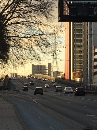
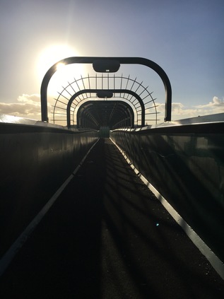
I stood rather distractedly at the apex of the junction, finding myself reminiscing about my previous visit. Trucks clattered onto the lower spans of the Lodge Avenue flyover ahead of me, and behind me a complex transaction was going down at the car wash, unfamiliar accents prattling angrily at each other, hands sliced down onto palms to seal the deal, ancient flip-phones clicked open. I felt comfortable here on the A13 - I knew this stretch of road well and oddly, held it in an almost fond regard. The downtrodden exterior of the Thatched House sat behind the familiar high metal fence in defiance of the latest Police application to curtail its opening hours. I turned west, climbing over the bridge and looking back over the brook. Below me, the path I'd walked with my elderly companion stretched away northwards, the chimney stacks of Eastbury Manor House red and tall against the pale blue of the sky. Now I knew the house sat there in the midst of the sweep of the estate, it was hard to miss its incongruous intrusion on the skyline. The sun was low on the western horizon, and I felt oddly close to the City despite it being a smudge in the red distance. I felt connected to the road, and wanted to walk it back to the towers of London. Instead I followed a staircase down from the parapet and followed a tunnel which burrowed under the A13. It wasn't clear if the tunnel had been bored through the concrete, or if the iron rings which lined it were an engineer's affectation. I emerged on the edge of the Thames View Estate, Mayes Brook slipping into view from my left and crossing under the path. From here I could ascend to the road again and walk the London-bound carriageway which slowly returned to earth alongside the brook up ahead. I knew what to expect at the junction with River Road - the brook slices under the street at an oblique angle, the bridge acting as a tidal sluice before the junction with the River Roding on it's final contortion towards the Thames. I crossed the street and reacquainted myself with the final accessible stretch of the brook - a deep concrete channel shored up by crossbeams. I navigated through the knot of streets of suburban housing which filled the space between here and the river, but couldn't get close to the outfall, which sits behind a private wharf. A fruitless excursion to the gates of the plant hire company which now occupies the space soon showed there was nothing doing. High security fencing, a locked gate and a guard post with no personnel. I headed rather forlornly back to the road and began to climb the slope which carries six lanes of traffic soaring over Barking Creek. Looking across the narrow stretch of land which separated me from the Thames the sun glinted off the silvery water and the metallic warehouses, ahead the Barking Barrier towered shadowy and black against the bright afternoon. I set off at a fair pace despite my tired feet - I'd set my sights on Canning Town as a perfect ending point, but it seems oddly distant. As my walk unravelled the sights of a prior journey I felt I'd begun to know the road better - a brief pause at the massive Beckton Sainsbury's then off again, passing the almost hallowed site of the Alp and into the golden sunset which was descending over the City, picking out the disconcertingly slender lines of Balfron Tower and the distant, silly tangle of the Orbit at Stratford. My walk had felt unplanned and insubstantial at the outset, and seemed unlikely to be a satisfying route. But somehow it had turned into an epic and oddly ritualistic unravelling of my year - of walking the eastern fringe and pushing out of the city, using the streams and waterways as a means of reading the terrain. There are still rivers to walk, old paths to resolve - but for now, at least, it was time to turn for home.
You can see a gallery of images from the walk here.
Lost::MikeGTN
I've had a home on the web for more years than I care to remember, and a few kind souls persuade me it's worth persisting with keeping it updated. This current incarnation of the site is centred around the blog posts which began back in 1999 as 'the daylog' and continued through my travels and tribulations during the following years.
I don't get out and about nearly as much these days, but I do try to record significant events and trips for posterity. You may also have arrived here by following the trail to my former music blog Songs Heard On Fast Trains. That content is preserved here too.
