Completing a project is something of an unfamiliar feeling here. It's rare I actually hold to a course for long enough to achieve any sort of goal, and even less common to feel that I've actually done justice to standards I've set myself. However, over the first five months of the year, as an act of either penance or thanksgiving depending on the overriding feeling at the time, I'd walked the five ordinal routes into London. So what to do now? I knew that my recording in writing of these routes was woefully behind - life without a perhaps somewhat extravagant laptop had curtailed my opportunities to bunker in the corner of a Costa Coffee and churn out words or retrospectively research places I'd found. But still, I needed to be out walking. June presented itself with a few options, but I had a hankering to get back out to the east of the city. I hadn't ventured east of the A1 since a fateful walk in December where I'd set out not really knowing where I'd head. So today, perhaps I'd try the same basic approach? I knew that I wanted to find evidence of a couple of streams in the east that hadn't figured in my treks before, and I had a rough idea of a way to combine them into a longer trip. I also had a hunch that I'd end up at the Museum of London Docklands at some point. I decided to throw all of this into an unplanned recipe for a day which should, after all, have been a celebration of freedom from rules or methods. This was probably not the soundest basis for planning a walk which needed to function as my treasured monthly excursion, but nonetheless, I set off into the suburbs.
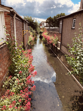
I was one of very few passengers to alight at Gidea Park. The brand new train I stepped from was intended to have sped me under the city, from Paddington directly here - but its purpose was humbled by the continued delay to Crossrail. Instead, it droned away east, mission foreshortened, leaving me on a quiet platform under unexpectedly leaden skies. I set off out of the station, aiming for the southern exit onto Station Road. My route took me further east along the railway fringe, passing south of the fan of sidings which housed inactive commuter trains between the peaks. I crossed Upper Brentwood Road which led north towards Gallows Corner, passing through suburbs which now covered the grounds of Hare Hall, a Palladian mansion completed in 1770 for John A Wallinger. The building, now much encroached upon by housing, has served as the Royal Liberty School since 1921 and has the distinction of being the first British school to install a computer - an Elliott 903 operated by paper tape, purchased in 1965. Beyond the junction, I headed along Squirrels Heath Lane. This name appears almost lost from the map aside from this lane and the adjoining road which stretched east to the administrative limit of London. Locally, it appears that Ardleigh Green is the preferred nomenclature, with its connotations of sleepy Essex village rather than the dangers of a bleak, rodent-plagued wasteland. Ironically perhaps, the hamlet from which this new name has slowly crept west was once Hardley Green, which is perhaps more descriptive of the sunbaked concrete and brick vista I found today. Nevertheless, near the patriotically proud point blocks of Elvet Road (Victoria, Elizabeth, Edinburgh, Mountbatten) I finally found my first target: from the edge of the David Lloyd leisure complex, the tiny Ravensbourne trickled in its narrow culvert.
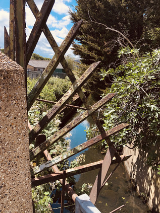
There are two Ravensbourne streams in London - and it is fair to say that this is the lesser in stature. Rising near Gallows Corner, and running between the backs of suburban streets, it makes a first accessible appearance here among the comfortably appointed homes of Havering. While its southern namesake strikes out across the wild spaces of Bromley Common, this little stalwart stream has done well to avoid enclosure during development - perhaps only saved by the need for surface drainage in order to build on the uncommonly flat floodplain here. My first sighting was inconclusive: a burst of greenery between two houses, and a tell-tale brick wall synchronising with a notable dip in the carriageway. It was going to be a day for this kind of evidence - stolen glimpses of sluggish water, traced by contour and instinct. I turned back and headed south along Northumberland Avenue, a long street of impressive detached properties which shadowed the river. Behind its back gardens was Haynes Park, for which the Ravensbourne formed the western perimeter - but there was no clear entrance from the north. Instead, I entered midway along the park's western side via a wide driveway surrounded by green municipal railings. The twin towers of Haynes Park Court overshadowed the park entrance, two of the smattering of tall blocks in an expanse of otherwise low-rise housing. Designed by Thompson and Whitehead who don't appear to have ventured into this type of work often, these blocks were erected for the rather prosaically named Multistorey Housing Association in 1966. They slumbered on, decaying into a rather grim state until recent refurbishment of the gloomy galleries and stairways. It's hard to say whether this was a result of their one grim moment of infamy when a young man plunged from the ninth floor of one of the blocks in 2012. I found few other references to the work of Thompson and Whitehead save for a tiny, modernist church in nearby Becontree dedicated to St. Cedd - bishop of the East Saxons and patron of Essex.
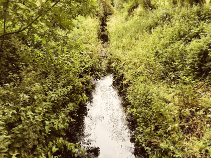
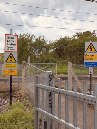
I let the river make the going, doglegging through the streets along its subtle contour line. After spying it passing under a fine little concrete balustraded bridge, I tracked the course via the appropriately named Brooklands Gardens, finding the Ravensbourne constrained in a deep culvert where Lewis Road inexplicable mutated into Warrington Gardens. Presumably, the river had at some point marked the boundary of developments here. I found it again in a marked depression on Hillview Avenue, behind a tidy brick wall with a well-secured metal access gate. I now had to pass a manmade barrier in the form of the Romford to Upminster railway line. This tiny link between the lines from Liverpool Street and Fenchurch Street survived against the odds, now part of the Overground network and served by a train shuttling back and forth via the single intermediate station at nearby Emerson Park. The line was unusual in being crossed by few bridges, and featuring instead a number of at-grade foot crossings. It was one of these I was aiming for now, via a surprisingly long diversion to the west and along a rutted back-lane behind homes and garages. During the cutting of the line in 1892 an unusual geology was uncovered, with sand and gravel overlying a thick bed of boulder clay. This signified the most southerly extent of the Anglian ice sheet during the longest and fiercest ice age of the Pleistocene era. The upper layers of sand had traveled from the Midlands, deposited here on the edge of the Ingrebourne valley some 450,000 years ago. The residents of South Hornchurch crossed the railway line with due care, seeming largely unawed by the great history of the clay dust their feet kicked up at the edge of the ballast. South of the railway I turned back east, finding the river again at its slewed crossing of Osborne Road before taking a turn into the long avenue of Lyndhurst Drive. The river was out-of-bounds again, ploughing between back gardens and then bordering allotments on the site of the former great house of Grey Towers. Built in 1876 for Lieutenant-Colonel Henry Holmes, the owner of the Hornchurch Brewery, the crenelated mansion passed into military ownership on the owner's death in 1914. Used initially as a depot and base for the 23rd Royal Fusiliers - the Sportsman's Regiment - from the summer of 1916 it became the New Zealand Convalescent Hospital with 1500 beds available for injured troops returning from the front line. Increasing casualties saw it expand by a further 1000 beds before it closed in 1919, with the last troops departing for New Zealand in February 1920. Pressure on land for suburban growth saw Grey Towers demolished in 1931. A nearby neighbour, the much older and somewhat grander Langtons - also built for a brewing family - was gifted to Hornchurch Urban District Council around the same time, but survived due to a covenant on the gift which required it to be used for municipal purposes. Langtons survives as the local Register Office and was briefly at the centre of a High Court case where its license lapsed and the legality of 193 marriages was placed in doubt. Meanwhile, no trace remains of Grey Towers, save for the name of a new development of houses near the allotments.
A crossing of the busy A124 caused me to re-orient myself: I'd passed this way before, and recalled the awkward bend at the bottom of a dip where I had to make a swift crossing of the busy east-west route at the venerable Ravens Bridge. Ahead of me, the broad green space of Harrow Lodge Park opened out, with the river and path sticking to the eastern edge and skirting the carefully prepared cricket pitch. The huge park was laid out on land donated by Richard Costain and Sons during their construction of Elm Park Garden City and occupies the site of the 16th-century manor house of Maylards. The park was pressed into use as a market garden during World War II, with the decommissioned fields redeveloped as leisure facilities after hostilities ceased. Around the same time, a comprehensive redesign of the park took place with the Ravensbourne dammed between 1954 and 1956 to form a large boating lake. I followed the river to its outfall on the lake, noting the sudden rise in the wind when I stepped away from the treeline. The lake surface was serrated with waves, the park largely quiet aside from the cluster of activity around the café. It made for pleasant walking, crossing the lake via a bridge at the centre and heading into the wilder part of the park to the north rather than following the path. In the event, all routes led to Upper Rainham Road and another familiar spot from my walk along the Beam River. I crossed carefully, heading along The Chase - a route I'd abandoned on my last walk as too treacherously busy with four-wheel drive vehicles conveying the local young women to an equestrian centre. This time I decided to persevere, swiftly finding the shameful spot where I'd crashed out of the woods beside the Beam and turned aside, cowed by the unexpectedly rural aspect of the zone I'd stumbled into. A little way to the south, the Ravensbourne trickled into the Beam, much reduced in feeding the great lake in Harrow Lodge Park. I followed the lane west, passing through the yard of the Eastminster School of Riding and into a narrow lane, overhung by trees. At some point, soon after passing the heavily fly-tipped opening of the path I felt like I'd passed out of suburban London entirely and into the lost farmland landscape of West Essex.
My route through Eastbrookend Country Park was perhaps the most pleasant part of the transition between the two rivers I planned to walk today. A relatively rural stretch between the park and neighbouring cemetery opened into an insalubrious lane frequented by cars with their engines running, edgy van drivers taking power naps and a cluster of Deliveroo staff holding some sort of clandestine workers' council. I soon met the curve of Dagenham Road which led into the edges of Becontree. The crossing of the great estate was hard going: the pavement tough on the feet and the strange monotony of the expansive sprawl of houses stretching seemingly forever. I found a shop to purchase lunch and ate on the hoof, not wanting to delay here. I struck a northwesterly path, aiming to cut across the central spine of Valence Avenue and to turn aside at Bennett's Castle Lane. My target was South Park on the edge of Ilford which felt impossibly distant as I slogged along the dry, windswept pavements walking into the gale. I felt stretched and tired, and the walk felt purposeless and vague. I briefly crossed my own path once again at the entrance to Goodmayes Park where the little Mayes Brook sputtered along unseen under the road. Compared to the rivulets I was tracking today, the brook felt like a more substantial target and I again began to doubt my purpose. Undeterred I stumbled on through the eerily homogenous bungalow-scape of the Mayfields Conservation Area, dumping my plastic bottle into one of the multitudes of recycling canisters on each identical driveway, surely a proliferation not expected when the area was designated in 1991 and the scourge of satellite 'dishes' was the borough's main concern? I finally emerged onto South Park Drive, realising that the entrances to the park were at the north and south extremities, and arriving squarely between the two I would need to walk the length of the park to enter. I cut my losses and headed south, tiny tantalising glimpses of the lake formed by Loxford Water inside the attractive green space.
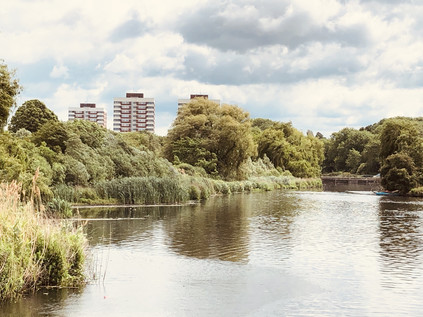
It's unclear where Loxford Water rises now, with the coming of the Great Eastern Railway and urbanisation of the area much altering the local geography. It flows into the ornamental lake in the park as the Seven Kings Water, a stream which was itself diverted to run along the northern side of Green Lane at some point prior to the late 19th century, rather than following the ancient line of Water Lane which was likely its original course. Above the confluence there appear to have been two streams, with the Loxford Water rising somewhere in the brickfields near Ilford Cemetary in a spot once known as Sam's Green. In any case, my first glimpse was of a narrow, buddleia lined channel between the homes on South Park Terrace. Unusually, as it cut across the pattern of streets - all aspirationally named for leafy Surrey suburbs - it appeared that the locals had embraced the stream. It was clean, free from dumped litter for the most part, and felt part of the urban geography of the suburb which bore its name. I tracked it south, dipping into the side-roads to steal glimpses as it converged on the main road, finally running in a deep, steep-sided concrete channel on the western flank of the street. I calculated that if the Seven Kings Water had in fact followed Water Lane it would have had joined the Loxford Water somewhere under the mini-roundabout on Dawlish Drive. I surveyed the scene - it all felt somewhat unlikely. The rivulet had gone native and now belonged to the suburbs, not the ancient countryside. I walked alongside it for as far as I could, pointing my camera through a fence at the point where it swung west behind Loxford Social Club, towards an impressive new school building. I continued south to the entrance to Barking Park where I could again walk alongside the Loxford Water as it edged around the long lake created from its flow. The park opened in 1898, the first such park to be operated by Barking Urban District Council, and it was widely regarded as the finest in East London at the time. The long lake was a major feature from the outset, once plied by a paddle steamer called Phoenix II which carried visitors almost the entire length of the park. The busy lido, closed since 1988 is now a 'splash park'. I tried to walk along the narrow sliver of land between the stream and the lake, but it soon proved impossible and I returned to the path around the southern shore of the lake. I found a bench somewhat sheltered from the wind and rested awhile. The park was busy with walkers, hunched against the unexpected windchill on an otherwise bright summer afternoon. I ruminated on my walk, figuring that perhaps it hadn't been entirely as dull as I worried it may be. I hoisted my bag for the last stretch of the walk, following the lake to the gate and taking a final look at Loxford Water under the bridge before it disappeared into a final culvert between industrial units which led to the banks of the River Roding. I noticed it was possible that I could see it one last time closer to the confluence, but I decided to turn aside and head for the station. There were other rivers that needed my attention now.
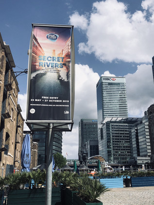
The train made the familiar, but always exhilarating journey across the rooftop-level viaducts of the East End, depositing me on the narrow platform at Limehouse. The station was laid out like an unearthed ancient arrowhead pointing at the city, formed by the convergence of DLR and railway. Feet tired, I took the lazy option, doubling back a few stops on the DLR to get to Canary Wharf. It seemed only fitting to approach the Museum of London Docklands via water, so I descended from the platforms to the dockside as soon as I could. The Canary Wharf estate had finally pulled off the ultimate regeneration trick: I remember weekend visits here years ago, being alone with the security guards in a deserted cityscape, but now the plazas and promenades were filled with people. This city outside the walls which had once been solely a workplace, abandoned outside office hours, now drew in an around-the-clock leisure-seeking crowd too. I navigated out of the busy, exclusive shopping centre and onto the waterside, crossing a bridge that afforded an excellent view of the inert Crossrail station currently functioning as an expensive roof-garden. The sun glinted from the surrounding towers, reflecting a cloud-flecked sky back at the dock surface. Across the bridge, in a Georgian sugar warehouse, the museum housed its latest exhibit: Secret Rivers. I'd vacillated about attending this event for some time, reasoning that I might be disappointed by something which skated too blithely over this topic which had occupied my thinking for so many years. Or perhaps it would take a prosaic tack, denying the rivers their ancient spiritual significance and talking up their industrial heritage over all else? I was relieved though to get over my vanity and visit because it turned out to be well-judged and balanced. The symbolic significance of London's lesser-known rivers was covered well, as was their gradual transition from rural streams to working rivers, and finally to shamefully culverted sewers. Some of the most interesting aspects of the exhibition centred on the rehabilitation of the rivers: by half-serious pressure groups, visual and audio artists, and of course in literature. A wall of books inspired by the rivers showed a long tradition of influence, and well described some parts of my own oft-repeated pathway to the banks of these streams. Not least, on one broad white wall, a quote from Aiden Andrew Dun describing the River Fleet:
The Fleet is a secret ditch, the kingdom of typhoid, a conduit of bad airVale Royal - Aiden Andrew Dun, 1995
The museum had done a fine job of pulling together the secular and sacred and had wrangled the attention of even the oddest cranks and freaks among us river-walkers away from our dubious texts and divining rods for now at least.
Perhaps the most arresting part of the display was a wall-sized map of the Thames estuary showing the tributaries of the river. I politely waited my turn for close inspection while a young family pored over South London. "You mean there's a river under our house!" a boy exclaimed to his amused mother, stabbing a pudgy finger at the convoluted line of the Effra. He was utterly captivated by the idea of a world under this one, entranced by something dark and presently formless, yet open to the imagination. I saw the spark of wonder which I'd found somewhat later than him - and I was thrilled to see it kindling the kind of excitement I still felt when I tramped about the suburbs on the trail of a rivulet or gully largely forgotten by most locals. I finally got my turn at the map and realised with a mixture of amusement and surprise that the rivers I'd walked today weren't there. Perhaps in my own childlike flight, I'd imagined them too? I set off west, towards the City, planning a call at the churchyard of St. Anne's in Limehouse where I knew a certain pyramid would be anchoring me to the earth, just like always. My history of London might be borrowed, butchered and misappropriated from all kinds of places, but that I could still lose myself here was very, very important.
A gallery of pictures from the walk and the exhibition are here.
The bus deposited me on the southern side of a broad dual-carriageway with a generous but unbarriered concrete median. The road was eerily silent. I paused, wondering quite where I was and feeling the familiar tingle of anxiety at not quite knowing what I'd let myself in for. Suddenly the sky tore open above me with the blistering sound of jet engines bringing a Boeing 747 to a shuddering, gravity-defying safe landing after a transatlantic crossing. I'd walked in the flight path before, but this was unlike anything I'd experienced. Silent again, I turned east, against my better judgement, in search of a place to start walking. As is so often the case, a river provided the boundary: The Duke of Northumberland's River - formerly the Isleworth Mill Stream - ploughed a straight furrow under the road, separating the village of Longford from the ancient parish of Harmondsworth. A single car passed by. I wondered if there was some sort of incident or road closure, but it seemed that beyond Heathrow the road dwindled in importance. I was able to cross unassailed, pausing to take a picture back west. Looking along the asphalt, the long walk ahead of me seemed almost impossible from here at the edge of London. Strictly speaking, the boundary lay a few yards further to the west where the River Colne passed beneath the A4, but this spot somehow felt right. Records indicate that this watercourse was being worked on in 1530, bringing the waters of the Colne to drive mills and irrigate the fast-draining farmland on the Duke's estate. It is also likely that the labourers were not digging a new ditch, but refettling an already extant channel. For centuries humanity had tinkered with this landscape, reshaping and redefining it. Here on the edge of one of the zones of London most overwritten by human activity but in many ways least human in scale, I'd start walking west along the ancient road from my homeland to London. Another aircraft shredded the cloud-cover, overwhelming my already music-battered hearing. I started walking...
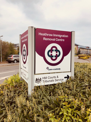
The road was still uncommonly quiet and, while initially shocking in its intensity, the regular rhythm of landing aircraft soon became reassuring background noise softened by the warm dead air of a Spring morning. I was, technically at least, in Harmondsworth. The Great West Road entered London at the historic crossing of the Colne in Longford and then turned aside from a long extant route which ran somewhat to the north, instead hugging the perimeter of the airport. The tiny remaining hamlet with its historic barn - the Cathedral of Middlesex - lay a little way along the older route. Unlike much of the parish it had escaped being devoured by the airport - so far - and existed in the midst of edgeland hotels, sprawling car parks and patches of scrubby, rough grass too blighted by noise and pollution to develop - but too much of an asset to dispose of. The only inkling of civilisation I found here was possibly a signal of just how uncivilised Britain can be: the twin Immigration Removal Centres, Colnbrook and Harmondsworth. Lying at the end of a snaking PFI-primped driveway, the nondescript blocks could have been insurance offices or utility company call-centres. But they weren't. These blocks housed people who were awaiting removal from the UK: perhaps because they had overstayed a Visa, committed a crime whilst in the country or in the most hand-wringingly sad cases, where some error of judgement or fact had put rules before reason. I had form with the UK Visas and Immigration department - and I had to say they'd always been polite, efficient and decent to me and my family. But we were paying for the premium service: fronting up for an on-the-day determination to prevent the gut-wrenching months of uncertain waiting. Beyond the moderately better customer experience, we were gatewayed into the same system and surfed the same challenges of the hostile environment. A word wrong here, an item of evidence misplaced or misdated and... Well, the situation was too much to contemplate - and the feeling of lingering outside these mystifying but compelling compounds made my bones ache with horror. I tried to move on, to turn my face to the east and head for the City, but I needed a picture to prove to myself that I'd been here. I snapped the shot and turned away, hurrying along the pavement. A little further on a UK Immigration Enforcement van passed me at low speed, u-turned zippily around the central reservation and came back for another pass. I pulled my hat brim lower and put my head down into the walk. Heathrow shimmered in the heat-haze of jet exhausts across the street: planes taxied and screeched into steep take-off. The van returned, pulling across my path at the entrance to an elaborate Chinese restaurant. Like all exchanges with the Home Office, it was quick, efficient and polite. The threat was implied, never explicit. They ruled out nefarious purpose by check-listed category: Did I have business at the centre as a visitor? Was I concerned about someone being held there? Was I secure in my own status in the UK? No, I wasn't, but it was more to do with botched Brexit and bad diplomacy than the Immigration Act. They let me move along, careful not to mention the camera or the picture, knowing they had little jurisdiction. Rattled but oddly vitalised by this unexpected encounter, I continued walking. Such events seem almost passé now - the urban wanderer disentitled from his or her (but usually, of course, his) rights in some liminal area where justice and access were not guaranteed. Whether it was the ubiquitous Ikea carpark or a Home Office Detention Centre, the truth was we sought the thrill of a challenge - even if the encounter would be fraught with misunderstanding and excruciatingly difficult to manage, given British sensibilities.
Despite the careful ministrations of the Home Office, it was actually rather hard to determine if this was still Britain at all. The landscape here was generic airport: low-rise hotel blocks crept along the road, filling the gaps left by aeronautical businesses which clustered around the perimeter road seeking an address as close to Heathrow as practically possible. The fence was endless, and I was aware of an internal system of heavily-trafficked roads within the Airport which paralleled my own, comparatively quiet route. Yawning pre-flight families stretched their legs via a turn around the hotel carparks. They had nothing to do before heading into the maelstrom of retail and restaurants, but instinctively wanted to put off their airside incarceration. Staying near the hotel had no doubt seemed like an ideal proposition, but it meant filling those long, dead hours before check-in opened with something other than a frenzied dash to Heathrow. Some of them sauntered along the A4, nonchalantly hopping the barrier to cross to the Starbucks franchise which nestled against the fence. Others sat on luggage, staring at the ground and waiting for the shuttle-bus which would whirl them around the perimeter and slowly towards the Central Bus Station, like the last trickle of a draining sink. Slowly, civilisation returned in the form of a string of semi-detached houses which invariably proxied a return to the urban on all of my walks in this series. Here, directly under the flight path life continued despite the desolate, lost acres of secured tarmac and grass nearby. Indeed, tucked inside the secure perimeter, just feet from the teeming tunnel which funnelled passengers into the airport, an inconspicuous and much-ignored cannon barrel stood as a monument to General William Roy's Anglo-French survey, a superbly accurate mapping exercise which commenced with a line from here south towards Kingston, effectively launching the Ordnance Survey. Roy didn't live to see his scientific advances cover the whole of the British Isles, but the scale of his achievement was certainly celebrated in his lifetime. In 1793 he was awarded the Copley medal by the Royal Society with the simple citation: "For his Measurement of a Base on Hounslow Heath".
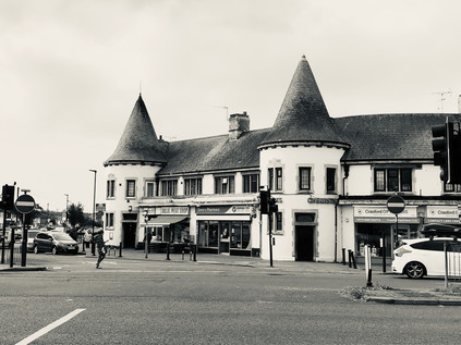
Again, a river marked the transition: this time the Crane, this stretch still unwalked after abandoning my attempt last summer. It passed under a stone-balustraded bridge inscribed with the arms of Middlesex having wound its convoluted way here from Harrow as the Yeading Brook. My memory of Cranford wasn't challenged by a new approach from the west: it remained a tired and decrepit place. The quiet and rather dull little High Street turned north, heading for the bus stop where I'd bailed out last time, while the main focus of the village had shifted here to run along the Bath Road. The parades of shops and homes, largely dating from the 1930s had intermittently been demolished to provide space for barcode-fronted hotel blocks - maybe signifying the last possible zone where a business could legitimately include 'Heathrow' in its name perhaps? At the heart of Cranford, or at least what passed for it now, the crossroads at Berkeley Parade spanned the road. Each southern corner featured a short run of local shops, adorned with a mock gatehouse bearing twin, chateau-like conical towers. Under these oddities the usual suspects traded: hair and beauty, betting shop, Halal butcher, Kebab takeaway. Between the arms of the parade, a filling station had been ingeniously nestled into the traffic island, but had now become an inexplicably 'American' car wash. On the northwestern corner of the junction, the Berkeley Arms Hotel mimicked the towers and turrets, taking them up a notch towards the grandiose, despite now functioning as an adjunct to the massive new Doubletree by Hilton next door. The final corner was left to a scrap of grass, untouched by a housing development which had crept towards the crossroads but given up short. Perhaps this unkempt litter-trap was a vestige of the cherry orchards which once edged down to the Crane before the building boom of the interwar years? Maybe this was the only authentic spot to be found at this weirdly deceptive way-station on the Great West Road.
I wasn't sorry to leave Cranford, despite an acute awareness of my need to return at some point to complete the navigation of the River Crane. Departure also necessitated a crossing of the interminably congested and treacherous 'Parkway'. This relentlessly busy north-south route had grown in importance beyond its design, cutting off a useful corner between Heathrow and the M4 and linking to the northwestern suburbs more directly than any of the more major routes. This fistula between the quadrants was a remnant of the Ringways plan, but benefited from none of the associated engineering - thus it was a channel of broken glass and decaying memorial flowers. There was no pedestrian provision for the trajectory I was taking. A subway portal leading to the south-western corner of the roundabout was the only viable option for walkers. Instead I had to chance the ebb-and-flow of the traffic, negotiating with drivers slowing for the turn, or speeding away from it. Waggoners Roundabout was named for the Jolly Waggoner, a long-standing staging post on the road out of London which was now an Indian restaurant, along with an opportunistic and fairly basic offer of rooms for the confused traveller taken in by their website's 'near Heathrow' or 'minutes to Twickenham stadium' spiel. Neither of these claims, ambiguous and inaccurate as they were, compared to the bare-faced audacity of claiming that it is well-situated for 'the best of Hounslow'. A trickle of guests left for their long circuit to the airport entrance or today's Rugby international, shoulders slumped, composing their TripAdvisor reviews as they rubbed sleepless eyes and worried about making their flights. Beyond this forlorn spot, the northern flank of the A4 rather suddenly gave way to farmland, save for an impromptu airport parking concern which had set up camp on the fringe of the field. While my route would pass a few streets from areas of parkland, this was my last chance to get close to nature from the pavement so I savoured it carefully, This was a tiny corner of the vast tract of Hounslow Heath which once straddled the routes into London from the south and west, providing campsites for armies and cover for cutpurses since time immemorial. Now, the suburbs had swept in like a tide, leaving a litter of low-rise former council houses in their wake. But these ancient arterial routes are defined by their wayside taverns, and at the next junction the textbook transformation had taken place: the huge mock-tudor 1920s Traveller's Friend with its towering brick chimneys and multiple gables had morphed into a McDonalds.
I've written before about these sprawling interwar public houses along the routes into London, perhaps incorrectly describing them as 'roadhouses'. There certainly are many such places on the trunk roads of Britain, but these earlier arrivals on the scene are more properly termed 'improved pubs'. As the era of motoring for leisure and business dawned and the UK road network began to expand into something close to its current shape, many tiny and old-fashioned drinking establishments along the way received huge investment from the brewing industry. This was a conscious attempt to lend some respectability to drinking places, adding restaurants, opening up the lounge bar and displaying a grudging acceptance of men and women drinking together. However, there was always something a little louche about these places - located out-of-town, often in suburbs which hadn't yet quite solidified around them. They were places not to be seen, where exotic entertainment thrived and where the serious business of boozing played second fiddle - a shift which would continue as the century wore on. In some ways they led successive waves of suburban architectural style: in the 1920s 'tudorbethan' was popularised by the rebuilding of old inns in the style of The Traveller's Friend here in Hounslow. Later, as the roadhouses emerged along the new dual-carriageways which scythed across once open country where there were no older pubs to improve, it was in the Moderne style: smooth concrete and steel for a new, streamlined world. Here at Henlys Roundabout, roads both old and new converged: my route in from the west met the end of the A30 - the Great South West Road which began its long journey to Exeter and Land's End, remaining remarkably faithful to the ancient tracks recorded by John Ogilby - His Majesty's Cosmographer and Geographic Printer - in the 1675 Britannia Atlas. The old road to London continued ahead taking a straighter route than mine, but snarling and stalling into Hounslow's town centre. Instead I struck out along the new Great West Road, built in 1925 along a straight alignment through largely open countryside. The road east still felt broad, modern and optimistic, despite the presence of towering digital billboards hired by an organisation called 'Brexit Express', urging drivers to 'Take Back Control'. Brexit haunted these approaches to London. It was impossible to escape the impending sense of its coming, but like a traffic jam on the A4 no-one quite knew when it would arrive or what we'd find at the end of it.
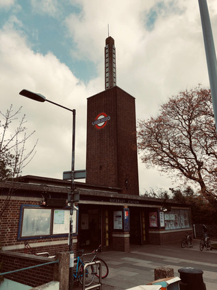
Suburbia had encroached on the stretch of straight new road which I was now walking, enclosing it in a halo of comforting banality after the nerve-jangling junction crossings I'd navigated. This area between Heston and Hounslow was slow to develop, with the Hounslow & Metropolitan Railway passing by from 1883 but taking a deep swing to the south, and leaving the pattern of tiny villages and lanes here until well into the last years of the 19th century. The tiny hamlets of Sutton and Lampton were removed from the map gradually, but surely. Their names captured and surviving only in side-streets, parks and schools. The clusters of shops around the former village centers had in each case become a hotel - Sutton had the Master Robert, a fine old 1930s pile, at least until its demolition for a much debated new Ibis Styles. Meanwhile the imposing, grey slab of the Park Grand rose over the road at Lampton, claiming only moderately dishonestly to be ideally situated for Heathrow. It was in the same general quadrant of the map of course, but this could be a world away from the security cordons and perimeter roads of the airport, which felt like they were in another territory entirely. The pavement stretched ahead, the horizon only broken by the curious concrete totem atop Osterley Station. The station building was reconstructed abbutting the Great West Road in 1934, replacing the former Osterley & Spring Grove further to the east, near to the grand Thornbury House and little else. The brick tower and concrete spike looked like a lightning-rod drawing the energy of those interwar years of municipalism. It was the work of Stanley Heaps - who became Chief Architect for the Underground on the early death of Leslie Green in 1908. Heaps' presided over the introduction of escalators to stations from 1911, designing the first stations specifically constructed to use them by adapting the archetypal two-storey oxblood terracotta tiled design which Green had perfected. Heaps' tenure also overlapped with the great Charles Holden whose streamlined, modernist designs for the City & South London Railway extension (now the Northern Line) had been selected in preference to his own rural pavillion-style buildings by Frank Pick. While Holden was commissioned to work on many of the numerous new stations constructed during the 1930s, Heaps tended to take on the minor projects and lesser-used extremities of of the network. Hence, his futuristic and imposing building at Osterley soars over the low-rise suburb, more like a modern estate church than a transport nexus and with a knowing nod to Holden's style. The railway was extended to new stations serving the growing town of Hounslow and eventually to Heathrow Airport, but Osterley remained a rather drab and quiet place. Beside the station was an abandoned bridge crossing over the tracks but heading in completely the wrong direction, wide enough for a line of traffic but grassed over with access only on foot. A glance at a historic map had this crossing here from the outset in the 1880s: a sturdy and remarkably well-made structure carrying only a farm track between divided lots of land. It survived rather miraculously beside the Underground station and the shuddering traffic - a bridge to nowhere surrounded by modern suburbs and hemmed in by busy railways and roads.
In so far as Osterley was a real place, it didn't extend far beyond its eponymous Underground connection. Away from the road, removed from the suburban sprawl in a large tract of parkland stood Osterley Park, built for banker Sir Thomas Gresham in the 1570s following his purchase of the manor of Osterley, this impressive Elizabethan pile was one of a ring of fine manor houses which would once have felt remote from London. The brick tower of the station felt like a modern, single-fingered salute to the great city dynasties, and beyond it the Great West Road returned to suburban mundanity. Comfortable villas rested behind service roads, cycleways and barely-used pavements, some of their stones cracked by the swift turn of vehicles onto driveways. The mock-tudor theme was carried into the Osterley Park Hotel, a sprawling while building with just too much of a hint of Fawlty Towers about it to be entirely convincing. The carpark was surrounded by the kind of low-rise motel blocks which belonged on a Midwestern Interstate. This place shared all their downtrodden sleaze and none of the romance of the road. It was hard to forget at this junction, that the Great West Road was once the height of modernity - a hopeful, gleaming stretch of pristine factories stretching towards London and manufacturing the newest things: wirelesses, disposable razors, processed foods. The white-heat of early-20th century progress had played out along The Golden Mile, before being cruelly cut short by World War II and the following austere years where consumption was regulated, and luxury impossible. The change in tone began in earnest at Gillette Corner, where Syon Lane crossed the road at an oblique angle, allowing a wide sweep of land to wedge up against the road. Here, in dark brick and great sweeps of steel-framed glass, Sir Banister Fletcher Jr's imposing and vast Gillette Building glowered across the cement plain of the suburbs. Atop its stacked, churchlike tower a copper cap and an illuminated clock still radiated progress and modernism despite the decline of industry in the surrounding area. Now at risk of redevelopment as a business park and residential zone, the building is at least listed. Other examples of classic commercial and industrial architecture hadn't fared so well here. Not least the once equally mighty Firestone Building, designed by Wallis, Gilbert and Partners and finished by 1928 and modelled on an Egyptian temple. The style was then rather jauntily known as 'jazz moderne' but later more familiar as Art Deco. The Firestone Company ceased using the site in 1979, and the area was threatened with dereliction. Minded to save the impressive building, Michael Hesletine at that time Environment Minister, intended to list it. A tip-off to the developer, commonly thought to be from within his department, saw the bulldozers move in over the August Bank Holiday weekend of 1980, and the building was gone save for the striking perimeter wall topped with decorative lamps. In some senses, this destructive and needless loss saved much Interwar architecture, with Heseltine swiftly moving to protect the Hoover factory and Battersea Power Station from demolition. But the loss was great, and the Golden Mile still bears the scars. The roll-call of consumer products and technological marvels which were once manufactured here seems mundane now, but would have been groundbreakingly futuristic: cosmetics and toothpaste, radios and gyroscopes, cars and fire-extinguishers. The statue of a sylph-like diver wasn't replicated atop Jantzen House, the inert modern residential block nearby named to memorialise the knitting mill, and the aroma of baking and hot sugar no longer emanated from the biscuit factory. In fact, on a windy Saturday the Great West Road was eerily quiet. A few cars nosed carefully into the traffic as they exited the Syon Clinic, a private healthcare facility which now occupied the former Coty factory, and the turning-lane bore the tyre-marks of heroic spins across three carriageways of traffic to access the HQ of Sky TV. The road was quiet though, its best years long behind it and a faded glamour only barely showing through the grimy, smoked glass fronts of modern offices.
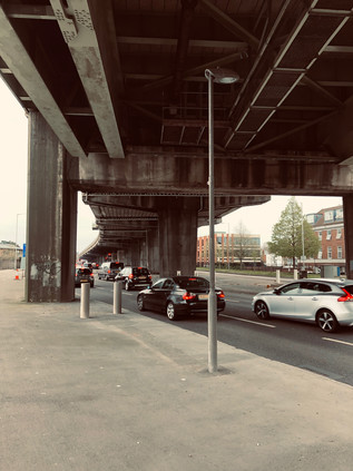
An almost imperceptible dip in the road heralded the crossing of the River Brent. I had passed under this bridge on my last visit, almost entirely unaware of the road above except for its reflection in the flanks of the Glaxo SmithKline offices which snaked along the river as it plodded sluggishly towards the Thames. There was equally little trace of the former GWR railway line which crossed above the road here on its course towards Brentford Dock - an ill-starred and poorly used line which has remarkably survived for carriage of aggregates and refuse, now curtailed to a terminal north of the A4. Crossing the Brent felt like a reconnection, a sense of tying what had been a disconcerting and alien walk so far into my existing map of London. I was grateful to the persistent river for the familiarity and the context, as the Great West Road was a disorienting companion: modern but faded, broad and fast-flowing but now rather strangely empty of traffic. The reason for this quieter passage was nearby: curving in from the northwest following a crossing of Osterley Park which would surely never get off the planner's desktop nowadays, the M4 advanced on concrete stilts towards its predecessor. Edging ever closer, I watched the flash of metallic paintwork along the viaduct until it disappeared: the road was now above me, the massive buttresses which supported it marching along the central reservation. The air darkened, sunlight blocked by concrete and particulate pollution. A light rain began to fall, stirring up a foul traffic-tainted petrichor. I amazed myself by thinking suddenly and clearly that this did not feel like a good place to be walking at all. I've trudged my way around some congested, contested zones in the last few years, and inhaled more than my share of exhaust gases, but nowhere within the limits of the city had felt as avowedly anti-pedestrian as this. I crossed a minor road which doubled as a cross-town rat-run, disgorging traffic onto the lower level of the intricate stitching of roads, and walked almost directly into the path of a screeching Audi driver. She looked feral: a mix of horror and indignation passing across her face at the recognition that a pedestrian dared to stray into this zone. Another car or a motorcyclist would have been an acceptable collision: they had actively voted into this maelstrom of noise and filth. But a walker? They had no business here. I was mildly amazed to find the zone so repellant because, as a wide-eyed child consuming the most elaborate motorway junctions avidly in atlases, this masterpiece of engineering had often intrigued me for lost hours on end. I was fascinated by the subtle weave of the on- and off-ramps, slipped together so the schematic overhead looked like the instructions for tying a Sailor's knot. Up close, it remained a beautifully designed thing, and behind the haze of dust and the anti-semitic graffiti, I could appreciate what I'd seen all those years ago with the eye of a cartographer, if not with the feet of a pedestrian.
But for now, surviving the passage under the M4 became the priority. The locals appeared able to turn a blind eye to its omnipresence - amazingly a run of tumbling homes and a parade of semi-open stores still fronted the scene as they had long before the Motorway arrived. Carville Hall Park was divided by the road soon after its purchase as allotments and playing fields by Brentford Urban District Council after the First World War. The house in the southern part of the park, Clayponds, falling into gradual disrepair in public ownership. It was perhaps never a salubrious site, hemmed in by Kew Bridge Goods Yard and the tarmac strip of the improved Great West Road. Today it was busy with families and footballers, the humid grime on the air apparently no barrier to sports. The road bucked north to avoid the tip of a triangle of railway land undergoing dusty and rapid redevelopment, then turned south again fringing the extremities of Gunnersbury Park. As a public park, this space dates from 1925 when it was purchased by the Boroughs of Ealing and Acton, while lying wholly within Brentford. The purchase, from the Rothschild family, was driven by a desire to keep at bay the encroaching public housing which the perhaps more enlightened Borough was busily building. The corner of the huge park closest to the A4 was soon given over to Gunnersbury Cemetery, a formally laid-out memorial garden which controversially provided a home for a monument to the Katyn Massacre of 1940, where Soviet troops conducted the murder of 22,000 Polish citizens and military officials and buried their bodies in mass graves in Katyn Forest. The black obelisk was a controversial addition to the cemetery in 1976 following considerable pressure during the Cold War to prevent a commemorative site in Britain. From the footpath, fleeting glimpses of the white stone Commonwealth War Graves flitted between the trees as the traffic howled and hooted under the canopy created by the M4. This wasn't the most peaceful resting place perhaps, but it was a world away from the grim discoveries of 1942. The traffic snarled and shuddered to a halt, tail-lamps flicking on like a red wave rushing towards me in the shadow of the overhead carriageway. I had reached Chiswick Roundabout - the launch and ending point of my long tramp around the North and South Circular Roads which was, in a sense, the precursor to this series of foolhardy walks into London from all angles. The scenery was familiar, but distorted by approach from the west. I crossed the A406 at the point I'd set off, still a mess of roadworks and confusion, and made my way around three-quarters of the vast churning traffic island. I struck out along a footpath which I'd never noticed before beside the houses in Surrey Crescent, which climbed to meet the road which soared over the roundabout. Looking back I tried to picture the scene in 1959 when Jayne Mansfield opened the flyover. The view west was still futuristic - a shimmering field of metal and glass offices and car showrooms as far as I could see. But I imagined that they'd seen the future shaping up a little differently back then in the Atomic Age?
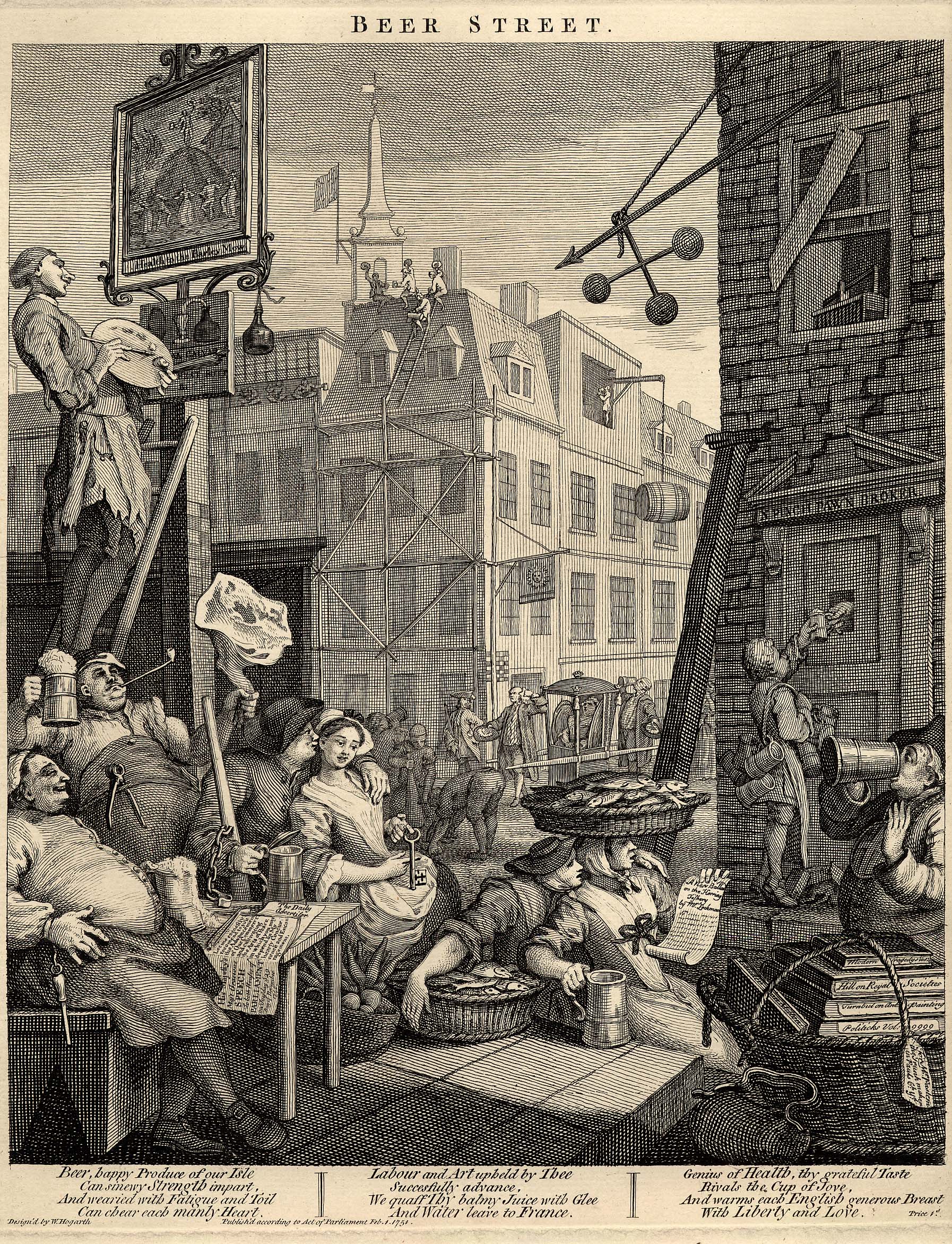
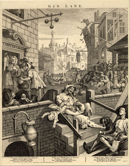
In the middle distance, a train crept slowly out of Gunnersbury Station as the sun began to seep from behind a thunderous-looking cloud overhead. The stretch of road ahead seemed impossibly long, and frankly a bit dull. I'd entered the kind of West London suburbs I used as a proxy for years when contemplating the outskirts of the City: tree-lined, red-roofed and repetitive. I glimpsed myself in the window of a Porsche dealership, and noticed what the apparently disapproving sales staff had spotted: this guy wasn't in the market for wheels of any kind. I was dusty, sun-pink and my fading cap was pushed back on my head to facilitate the long view ahead. Chiswick seemed endless, but drew to a nexus in the angle created by the Great Chertsey Road and the A4: here sat Chiswick House - once a Jacobean retreat from London for the Earls of Burlington, rebuilt in the Palladian fashion by the 3rd Earl in 1719 following his excursion to the continent. The house had finally passed into the ownership of Middlesex County Council in 1929, following a spell as Chiswick Asylum - notable for relatively enlightened treatment of those considered by the Courts as insane. The grounds remained open to the public, but the Great West Road was very much the back entrance to the grand gardens. A little further ahead on a triangular plot hemmed in beside a Premier Inn, was William Hogarth's house. Built around the same time as the Burlington's were reconstructing Chiswick House but on a much less grand scale, Hogarth moved here in 1749 and lived here until his death. He is much celebrated in the street names surround the area, and a map from the mid 20th century even records a surprising modern-style cash-in next door at the 'Hogarth Laundry'. The house has been variously threatened with undermining by sand excavation, damaged by wartime bombing and encroached upon greatly when the A4 was widened by demolishing a number of streets to the north of the site. But now repaired and spared further indignity the house remains as a museum and an ancient Mulberry tree still stands in the walled former orchard around the house, having been carefully nursed back to health by the staff of Kew Gardens following bomb damage.
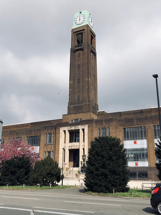
Hogarth's 'moralizing' paintings of London life are particularly relevant to this location too: his Beer Street depicting a happier, healthier population than the degenerate denizens of Gin Lane. Brewing has taken place at the nearby Griffin Brewery since the late 1600s according to Fuller, Smith and Turner - though the current brewery site began to expand after Hogarth's death, covering the green fields which he'd moved away from London to enjoy. The brewery today was a tumbling agglomeration of buildings of various vintages, stacked almost haphazardly behind a wrought-iron entrance gate. I'd visited once before, on a beery, now rather hazily remembered trip organised by a Highbridge publican. He'd borrowed a van from the local Sea Cadets and managed to score them a parking fine in a Residents Only zone, which he gleefully tossed out of the window as we screeched away homeward, bags clinking with bottled ale some of which didn't make it back to Somerset. As i walked the length of the brewery, I noted the wind rising and a marine bite on the air - the river was near, perhaps the nearest it would get on this walk, and I could taste and feel its presence. I'd briefly found myself on this stretch of road a while ago while making the crossing from Furnival Gardens, where Stamford Brook once flowed out into the Thames - once a busy working creek, until it was backfilled in 1936 as industrial use receded. Today I stayed north of the road beside Ernest Berry Webber's Town Hall building. Work started here immediately after completion of Dagenham Civic Centre and followed a similar pattern: a Portland Stone dressed lower level with red brick above in a style dubbed 'Swedish Georgian'. The impressive southern face of the building contained offices and a suitably forbidding entrance to the Treasurer's hall, flanked by stone carvings of the face of Father Thames by George Alexander, and likely some of his final civic work. The Town Hall was extended somewhat unsympathetically in the 1970s, the three huge arched bays of its grand, northern entrance lost behind a vehicle access and a tangle of stairways linking the new building to the old, however it remained in public use having endured the passing of the old Borough to the newly extended Hammersmith and Fulham in 1965. The street which ran the length of the building was named Nigel Playfair Avenue, in honour of the actor-manager of the Lyric Theatre. Originally located on Bradmore Grove but now operating in a modern building a short distance away, the auditorium was dismantled and reinstalled when the original premises was threatened with demolition in 1966. Playfair's exploits had previously been celebrated by other streets around the Town Hall, including Nigel Playfair Road and Macbeth Road - both obliterated when the Great West Road was extended towards the West End via the Cromwell Road Extension, which brought my route to the very doorstep of the City.
Plans to extend the Great West Road further into London had existed since the completion of the section to the Hogarth Roundabout in the 1930s. The planned route carved through Hammersmith, cutting into residential streets and gardens, and proved deeply unpopular. Instead the A4 decanted traffic unceremoniously onto the Broadway, clogging the busy junction between the two Hammersmith stations, before sluggishly stop-starting along Kensington High Street towards Hyde Park Corner. The Second World War throttled progress, but in the bold, post-war age of concrete and interventionism, a new plan was hatched for a slender flyover skirting the edge of Hammersmith on stilts to link the Great West Road with an upgraded continuation of Cromwell Road. The winning scheme was designed by Marples, Ridgeway and Partners - at the time still partly owned by then Transport Minister Ernest Marples who then scrambled to sell his shares via his partner. Soon after, the company secured the contract to build both the Chiswick Flyover and the Hendon Urban Motorway, despite reported lower bids being tabled by rivals. The dual carriageway would ascend on elegant reinforced concrete spans, carrying a system of heated cables which would reduce the need to salt or grit the road when ice formed. Opening in 1961, the road was already carrying more traffic than had been foreseen, but was certainly reducing delays. The heating system was also a success until the first cold snap delivered Hammersmith & Fulham a £4000 electricity bill. A tussle over payment saw the London County Council pick up the tab, but then swiftly stop using the cables in preference to regular gritting during cold weather. This almost spelled the end for the flyover, and in 2011 the whole structure closed due to serious safety concerns: the concrete cores of the pillars had corroded following fifty winters of salt and grit application. Transport for London raced to repair the strategic route in advance of the Olympic Games - money was no object when the IOC were coming to town it seems. Forced to turn aside by the flyover, I detoured briefly into Hammersmith to visit an old haunt for coffee. The knot of streets around The Broadway was pleasantly busy, the afternoon brightening as I headed east. It was soon time to return to the road for a last push into London. The flyover slowly touched-down on a windswept stretch of road between modern office blocks and hotels. I was the only pedestrian again, my progress along the semi-private stretch of pavement watched by almost pointless security cameras. Ahead, the bulky brick piles of Hammersmith and Fulham College filled what was once the playing field of St. Paul's School. In 1891, the view here had been so pleasantly rural that architect Frederick Wheeler selected Colet Gardens for St. Paul's Studios, a terrace of brick and terracotta dwellings for 'bachelor artists' which included lofty, arched double-height windows providing light and views across the fields. With Baron's Court station tucked neatly behind the studios, and a colony of artists already living nearby including Edward Burne-Jones, the well-connected location was swiftly popular with a series of young, up and coming painters. Now the studios looked over the relentless A4, a far cry from Wheeler's plan but still fetching prices which excluded even the most well-connected struggling artists.
The road was beginning to slow down, becoming a continuous line of city-bound traffic which nudged, nose-to-tail onwards. I passed over the complicated tangle of Underground and Overground lines which marked something of a boundary in the shadow of William Whiteley's Repository. Whiteley is widely regarded as the father of the modern British department store, having been inspired to become the 'universal provider' by a visit to the Great Exhibition in 1851 where he saw the wares of the British Empire laid out as if on sale. Learning the trade in the City while he forewent tobacco and alcohol to save the means to open a store, Whiteley opened his first premises in Westbourne Grove. He slowly purchased adjoining stores to assure him by 1875 of an unbroken run of shopfronts on the upmarket Queensway, from which developed a grand store in which he boasted he could sell everything from 'an elephant to a pin'. Here, beside the A4 his equally grand and capacious Furniture Depository still stood - a huge, ornate block which still dwarfed surrounding buildings boasting on its facade 'furniture and pianos displayed in mocked rooms' in a harbinger of the coming world of Ikea. Whiteley showed remarkable acumen, broadening his appeal by adding meat and poultry counters as the neighbourhood became less salubrious and more working class, but inciting the dismay of rival traders who protested his encroachment into their markets. His store was targeted by arson attacks on at least three occasions, reputedly from rivals who resented his all-encompassing business model. Whiteley's empire-building was unceremoniously curtailed by his murder on 24th January 1907, when he was shot dead at his store by Horace Rayner who claimed to be his illegitimate son. Found guilty and expected to hang despite a plea of temporary insanity, Rayner's sentence was commuted to life imprisonment when evidence indicated that the apparently generous and egalitarian Whiteley had not been quite the benefactor to his 6,000 staff which it appeared - in fact, he had been a bully and a serial philanderer. His family continued the business until 1912 when they sold to his arch-rival Gordon Selfridge, who had in recent times commenced trading on Oxford Street in his own great store. Whiteley's own palatial Queensway building remains, now an upmarket shopping mall bearing his name, while his Repository stared-down a gargantuan Tesco Extra across the railway tracks. It was hard to imagine William Whiteley not being impressed by quite how they'd packed a little of everything into the bright modern store.
A little further on, the A4 ceased any pretence at being an expressway, the dual carriageways merging into a single four-lane traffic jam between an avenue of mature trees and tall red-brick mansion blocks. This was the characteristic western suburb I'd grown to know in my earliest forays from Paddington. A little faded, but clearly still expensive and exclusive. I noted the crowds on the pavement thickening as I approached Gloucester Road station with its surrounding bloom of hotels formed from grand townhouses. The fine entrances from the street into opulent reception areas didn't convey how tiny the subdivided guest rooms were, or that there was likely no elevator available for the vast amounts of luggage just decanted from a Piccadilly Line train direct from Heathrow. It occurred to me that these arriving tourists had made the same journey as I - off the runway, over the Crane and under the suburbs to what they regarded as the 'real London'. I remained to be convinced, and while the grandeur of Albertopolis was almost enough to divert me into side-streets for better views of the sublime Natural History Museum or the Victoria & Albert, my bloody-minded refusal to get out of the way of the tourists hurrying and jostling towards me won out. I - quite literally - pushed on, into the crowd, accidentally cannoning into meanderers who stopped short to survey a telephone kiosk or some other on-brand bit of British street furniture. I realised that I'm at my worst in these areas, and that's largely why I avoid them. It wasn't outright snobbishness - more a mortal and an ever-present fear of becoming a snob. I've always been content to leave these zones to the tourists and the tour guides, let them mass on the pavement and impart stories which are far more compelling than those I rustle up from the docile suburbs. I passed into Kensington and things became even more congested and impassable. Harrods was a magnet, the looming, leering bulk of the gaudy frontage covered and under maintenance. People still snapped avidly at it, before sneaking inside for a carrier bag. The real customers cruised the A4 in high-end Mercedes and Bentleys, looking for on-street parking in the most conspicuous places possible. Beaten out by alert Uber drivers, they cursed and circled again, determined to be seen in the right car, in the right place. Here in the west, even the choice of illegal parking spot was a significant lifestyle matter. Head down, I pressed ahead to surface at Hyde Park Corner where there was at least some respite as the crowds peeled away towards Buckingham Palace. Piccadilly was a surprisingly pleasant walk, the quiet Portland Stone edifices of clubland giving away no secrets, and clearly expecting nothing of a perambulator from the suburbs. I felt at peace with my surroundings for the first time since crossing the railway back in Kensington. I was also acutely aware of the expectations on me to capture this part of the walk: people would call it 'the interesting bit' - far preferably to banging on about the marginalia. I was a poor witness though, content to let the city unravel around me as I walked back into the crowds at Piccadilly Circus briefly, before turning south onto Haymarket. Despite being the edge of Theatreland, all was quiet here: the matinees had begun, and the street would be quiet until early evening. The sun had made a break for it above me, and walking was now pleasant and warm. I looked forward to being able to get onto more familiar territory again, feeling a little lost out here in the West End. At the sight of George III on horseback, I turned east once again - the home straight was in sight.
Children slithered over the backs of the bronze lions of Trafalgar Square, barely able to stabilise themselves for the inevitable picture. Pigeons swarmed, more numerous almost than people. Buses jostled end-to-end. It duplicated the expectations, like every visit here - and like every filmed moment here - always did. Strangely though, I felt charitable towards the crowds who lolled outside the National Portrait Gallery or padded around taking selfies in telephone boxes. The city they came to see was the same one I travelled to for each of these walks - it was built on an international reputation which had allowed it to become the sprawling, confusing mess which I wanted to explore and understand. Without them, there would be no weird edgelands around Heathrow Airport, no endless suburbs stretching from the Crane to the Brent, and maybe no graceful concrete arc of M4 curving in from the suburbs. It could all be so different, but their celebration of a London I barely recognised outside a Richard Curtis movie or that one, clumsy two-part episode of Friends enabled the city I visited to exist, to work, to persist. As I passed the site of Temple Bar and entered the City of London I thought back to the huge 'Taking Back Control' billboards I'd seen in Cranford. The future was uncertain, our role as a financial power in the balance. Everything built here had sustained crashes and disasters before, but this time things felt self-imposed and stupid. It felt wilful and utterly British: a national cutting off of the nose, our face about to be mortally spited. I felt a mix of pride and vitriol: that I could walk these long routes safely and free from impediment was utterly British in character, but so was arrival in a place which might just be about to undergo self-immolation. The A4 proceeded along The Strand, into the City and down Ludgate Hill into the valley of the Fleet. I should have taken a final turn into Fetter Lane to conclude my route at a non-descript junction marked by a statue of Albert, Prince Consort who might just have been the patron deity of this last section of the route. Instead, I lifted my eyes to the dome of St. Pauls Cathedral and walked on, pausing to pay my respects to the Phoenix at the South Door. A little further on, once again revealed after a long disappearance from view, London Stone was visible behind clean glass and surrounded by fresh stonework. For years I'd grown used to peering down at the edge of the pavement, through a stained, yellowish window at the nondescript lump of rock. Now it could be seen properly - an irregular calcinate loaf of uncertain age, but certainly here for centuries. This felt like a fitting place to end the walk, at the very centre of London's onion-skin of layers. The clouds shifted overhead promising a fine evening after all the glowering storminess of the day. I almost regretted there wasn't further to go. But for now, this would do perfectly.
You can find more pictures from the walk here.
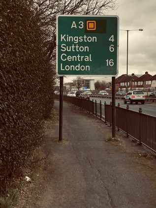
I often write about being outside my comfort zone or having transgressed the boundaries which define my normal territory. In some ways, I've made a hobby out of challenging myself in terms of range and geography, however modestly. Today was different though - I really was in uncharted territory. This wasn't nearly as dangerous as it sounds - I was in Surrey. The south-western quadrant of London is largely a closed book to me, and I confess that in part this is due to a prejudice against the leafy comfort and perceived dullness of the stockbroker belt. I've occasionally transgressed: a conference at Kingston University saw me bunked in student accommodation at Seething Wells one overheated, sweaty summer weekend in 2004, and there was, of course, my excursion to J G Ballard's home just over the border in Shepperton. Otherwise, though, I've steered clear. I knew my wanderings would bring me here one day, just as the south-east was finally opened to me by way of rivers and roads which needed to be explored. But I'd left what I saw as the meagrest pickings until last, politely pushing them around the plate with my fork in the process. But now here I was disembarking at Thames Ditton - high above a flat, green landscape of privet hedges and driveways. The ageing electric train shuddered off towards its final call at Hampton Court as I descended to the road below. I was a fair distance from where I planned to start walking the A3, partly because the road executes a sweeping curve from the south to the east here. I'd contemplated starting at Chessington and heading west to the road, but it appeared to involve trudging a network of fast-trafficked, narrow rat-runs without pavements. Here however it was calm, quiet and eerily still. Perhaps a little too quiet? I imagined curtains twitching and neighbourhood watch call-lists being activated as I shambled scruffily along the street, stopping only to snap a picture of The Wrythe - a sorry little stream trapped between driveways and suspiciously full of builders rubble. Surrey had its secrets, it seems - but today I was heading for a comparatively prominent feature on the map. I skirted the apparently affluent and rather quaint village centre, turning south towards Giggs Hill Green and the apparently slightly less exclusive Hinchley Wood. A children's football tournament was underway, and I become swiftly embroiled in a crowd of fathers offering sage advice, a hand on the shoulder as they approached the pitch. On the other side of the street, an identical stream of men commiserated muddy charges back to their Range Rovers, banging the heavy clay from expensive boots on the fender. I crossed Portsmouth Road, the former route of the A3 before it was very comprehensively bypassed. It remained a busy road through the suburbs, and I pondered the choices I'd made here. Walking the modern route of the road felt right in terms of my project, but wrong in terms of this unexplored territory. I knew the environs of the A1 and A2 well enough, and I'd accidentally covered the ground their older routes traversed on other walks - but here I had little or no prior experience and I felt unprepared. The quiet backstreet I was wandering ended suddenly at a junction with the busy Kingston Bypass which merged with the A3 a little way ahead. But my decisions were made already, and I set off eastwards, towards the major road into London.
The Kingston Bypass met the A3 in a collision of old-school suburban bypass and modern, sweeping motorway-standard road. The arms of the older road splayed and opened to accommodate the new road, sweeping in from the south and turning sharply east. In the midst of this sprawled junction, broad grassy slopes sparkling with discarded plastic litter were crossed by a footpath - if I'd headed in from Chessington and braved the nervous pathless lanes, I'd have arrived here after a walk of a similar length. The slip roads blended into the main carriageway effortlessly, amongst a landscape of scrubby pasture, abandoned market gardens and occasional flapping roadside banners advertising equestrian businesses. This was the tattered edge of Surrey - the zone where the comfort and calm of the stockbroker belt merged into the enervated edges of London. It was here where commuting city workers would feel the pressure of their collars and the weight of their burdens as they motored gracefully around the curve and over the boundary. Of all the directions I've entered London, it was the most indistinct and the least prepossessing. As the arc of the A3 tapered into a long straight, dipping under the Hook Underpass ahead, my path took the northern flank of the remains of the old Kingston Bypass, a superseded road which ran alongside its modern counterpart but didn't fully connect. Just a short leap and a metal barrier away, traffic flashed by at high speed - but beside me all was quiet. I calculated I was closing on the spot where London began and looked for signs. There were several, but none were official: a fence ran along a ditch and the roadside vegetation was replaced by a familiar sort of 1970s noise-baffling concrete barrier which graced many urban roads into the city. At the very spot where I calculated that the line was crossed a dead fox was splayed on the verge, red-furred and graceful even after an apparently swift death. The road had claimed a sacrifice already today it seemed. Looking back over the eight lanes of tarmac, a sign facing west welcomed drivers to Surrey. There was no welcome on the road ahead.
The footway ascended to cross the A243, the underpass below narrowing and slowing as the more conservative speed limits of London brought thundering suburbanites to more reasonable speeds. This was reportedly the first such grade-separated underpass in the UK, originally opening with an innovative but incredibly noisy and inefficient heating system to prevent ice formation in the depths of the cutting which delved beneath the roundabout. My path skirted the sliproad onto the A3, passing a seemingly dull branch of Topps Tiles which had a more exciting heyday. This was the Ace of Spades: a huge roadhouse sited on the A3, marking the passage into or out of London. The venue featured an 800-seat restaurant which never closed, a swimming pool, a miniature golf course and offered cabaret until 3 am. Built in the 1930s, the building was popular with early stars of stage and screen and was by contemporary accounts, the place to be seen in these parts. However, the Ace of Spades fell on harder times in the 1950s and much of the complex was consumed by a huge fire in 1955. The last remaining parts of the building are above the ground floor here - a run of mock-Tudor gables which would have fronted the road but now provide space for bright advertising graphics, glowering across the cutting at the 'Ace Pharmacy' which has appropriated the lineage. It's hard to imagine such scenes here now, in a drab car park outside a tile store. These pockets of suburban history seem unlikely and are sometimes at risk of loss to grander projects. Across the street, the Cap In Hand had closed too, its modern conservatory boarded up, marking the closure of another generously overlarge 1930s hostelry. If Wetherspoons couldn't make a stab at running a pub here, there's probably no hope for such roadside taverns on the A3 now. No-one leaves the road this early, or indeed this late. Ruminating on the idea of the 'roadhouse' and how it had all but disappeared after a final - and remarkably, still lingering - fling with Little Chef in the 1980s, I struck out for the great, grey monolith of Tolworth Tower which dominated the view ahead. By far the tallest building for miles this grey slab dominated the skyline impressively with the road leading apparently directly to its feet. It was designed and built in the International Style by Seifert and Partners, and although criticised for being an inner city building located on the fringer, it was very deliberately conceived for this suburban spot, initially housing a range of government offices and private concerns. Parking around the tower would allow efficient commuting, drawing workers away from the precincts of the City which even as Tolworth was being finished in 1964, remained an ailing post-war patchwork of bombsites and construction projects. Initially, the ground floor was occupied by the long since disappeared supermarket Fine Fare which was reputedly the largest such store in Europe at the time. Now it's a still surprisingly large Marks & Spencer Food Hall, while the northern wing of the building above operates as a Travelodge hotel. I stepped briefly into the store for supplies, emerging to skirt around the elegant concrete legs on which the tower strides to face the road. The busy run of shops on Tolworth Broadway was attracting a fair Saturday morning crowd under the shade of this incongruous interloper.
The road began a slight descent, noticeable only due to the long view ahead into a hazy morning. A thinning out of the typical mid-century villas which lined my route indicated the crossing of the Hogsmill River. Rising in Ewell and flowing north to the Thames, this was a waterway I'd yet to walk. The opportunity had never quite been right - and of course, the prejudice against this corner of London remaining strong. A flurry of greenery flanked the river as it slunk along the bottom of a shallow valley in a concrete culvert, striking out for the medieval crossing at Kingston where I'd first seen it years ago beside the Coronation Stone. The paths beside the river were invitingly cool, offering relief from the dusty sidewalks which were unenviably close to the road - but this project was now advanced enough to seem important and I managed to resist deviation from the plan. The road pulsed: alternately flowing freely and congealing into a long rope of red brake lights stretching ahead into the suburbs. The traffic beside me started to jostle for the correct lane for the junction ahead, where multiple retail opportunities converged on the road. This was Shannon Corner - so named, like many of these out-of-the-city traffic pinch points, for a former factory and local employer: Shannon Systems, supplier of office equipment. The junction was once a tangle of traffic lights and trolley bus wires, with routes to New Malden and Worcester Park conveying suburbanites back and forth across the bypass. Now it was a soaring overpass, carrying traffic over the fringes of B&Q and Halfords towards a second chance to exit for the gargantuan Tesco Extra, just in case there was something you'd forgotten on the first pass. At ground level, it was a drab and rather testing part of the walk. The morning was warming up, and the fine dry weather was throwing up the surface grime of the road as I walked. Little thought had been given to the pedestrian here: everyone arrived and departed by car with the access prioritised accordingly. I navigated the entrances to the store car parks and crossed the arms of the huge roundabout near the former Duke of Cambridge pub - now the unlikely home of a Krispy Kreme franchise. The path climbed again, the jaws of the junction reclosing on the A3 as it turned north and swung slightly to the west, taking advantage of the easy contours of the valley formed by the Beverley Brook. The road also entered a rather greener section here: the flat, fertile valley bottom was home to a string of sports venues ranging from five-a-side football to 'Jurassic Golf'. I settled into the rhythm of the walk now, enjoying the chance to stretch my legs and beginning to make a compromise with myself: this felt like a really long route, and I might not finish this walk in one excursion. Perhaps breaking my own self-imposed rules would be no bad thing though? I'd rather doggedly pursued this series of walks - sometimes against my instincts - and some recalibration might mean I didn't feel quite so compelled by the conceit I'd devised around the 'ordinals'? The road crossed the mainline railway heading for Wimbledon and I stopped briefly to watch a train passing in the now rather fine, bright morning. I also began to feel that perhaps I'd been harsher on this area than I needed to be: no doubt it differed from my usual experiences of suburban walking, but here, crossing and recrossing Brook and its culverted tributaries as I progressed north, it was hard to feel anything but pleased to be out here and intrigued by the possibilities of new routes and unexplored valleys. I mentally mapped the winding watercourses, knowing I'd want to revisit at some point when freed from the obligation of walking into the City.
Soon, I was passing under the shadow of tall green roadsigns which signalled the end of the A3 as a proxy-motorway. The traffic streaming by began to concertina in a flurry of tail-lamps as the junction approached. A huge expanse of common land extended away to the east, but to the west, the road was hemmed in by the suburb of Kingston Vale. This uncelebrated and disconnected area of low-rise, mostly privately-built homes nestled into the elbow of the old and new roads slumbered in the late-rising luxury of a weekend morning, except for the two curved parades of shops which formed a ceremonial gateway to Grasmere Avenue where a cumbersome footbridge across the bypass touched down. The area was as much dependent on the road as it was blighted by its presence: everyone drove here, the nearest station awkwardly distant. Known for centuries as Kingston Bottom due to the slopes down to the marshy land and the Beverley Brook, development here gathered pace in the 20th century. The car made these disconnected little suburbs possible and still sustained them today. Somewhere beyond the estate, the old A3 plodded down Kingston Hill towards our confluence. Along the way it passed Holmwood the £11m gothic pile which once belonged to Rolling Stone Ronnie Wood until he decamped to Ireland with a Russian cocktail waitress, leaving his ex-wife to stage a series of revenge auctions culminating in the sale of the sprawling property with views over Richmond Park. The property, widely dubbed a 'party palace' finally sold for a full £2m under the asking price, I'm sure providing just a little satisfaction to the wronged, former Mrs Wood. A further, more noble and perhaps less contemporary artistic link to Kingston Vale lay in the clean, modern lines of Dorich House an unusual building which at first glance appears to have more in common with a mid-century factory or power station than a dwelling. In fact it combines art, industry and domicile: purpose-built by sculptor Dora Gordine in 1936, the lower floors provide lofty studios, plaster rooms and storage while a modest apartment above provided a home for her and husband Richard Hare, Earl of Listowel. Until his death in 1966 they were something of a powerhouse in the promotion of Slavonic arts and culture. Gordine, once mentioned as perhaps the finest woman sculptor of her time, began to fade from the public eye on Hare's death as tastes and fashions changed around her. In the following years, she continued to amass a collection of Russian art which is exhibited at the house today. Vacant since her death in 1991, the Grade II listed building is now in the care of Kingston University and also provides a centre for female practitioners of the arts. Set on the leafy ridge overlooking the green sweep of Richmond Park, it's perhaps not so difficult to see the attraction of Kingston Vale to artists of all kinds: not out-of-the-way but a little hard to reach. Not quite out of London, but almost in the leafy fringes of Surrey. The old road and the new finally collided at Robin Hood. Here at a remarkably poorly-planned convergence six lanes of high-speed traffic funnelled into four, with an additional local flow from Kingston piling back into the fray. The junction snarled-up and unjammed periodically, traffic pulsing rather than flowing through the complex. The origins of the name Robin Hood here are vague but like all the best tales they have been absorbed into the local fabric, providing a geographical context for dry cleaners, off licenses and car dealerships alongside the lanes and walks which have existed since Tudor times on the park's edge. It is thought that Henry VIII's fascination with the myth of Robin Hood led to the inclusion of an outlaw character in the May Games which amused court on the ancient lands of Richmond Park each year, and certainly, the name is recorded locally in the 16th century as 'Robynhood Walke'. Later, the southeastern gate of the park which I was about to pass at the end of a grubby little terrace also adopted the name, as did a local ecclesiastical parish. Names have a habit of sticking fast on the edges of London, and while the north and east have Dick Turpin as their genus loci, the south shares its unlikely hero with Sherwood Forest. Sometimes, the reverse mythology completes the circle too, with the chaotic roar of the near-present immortalised in the picturesque. As I prepared to negotiate the tangle of pedestrian crossings at Robin Hood, I noted a pair of semi-detached homes behind tall hedges and tidy gardens with a small nameplate high on the wall which honoured the mighty A3 in their name: By-pass Cottages.
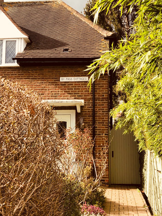
The Robin Hood Gate was set back from the road, a hint of the greenery inside the park just visible from the grey dust of the footpath, just a little way from my final crossing of the Beverley Brook. The bridge parapets would be barely visible to passing drivers, but on close examination they bore a record of an old boundary etched into their pollution-scoured stonework - to the west, Surrey County Council and to the east the former London County Council. The long slow drag up to Roehampton was still an administrative nexus, where the road marked a point where the Boroughs of Merton, Kingston and Richmond encircled a narrow outflung arm of Wandsworth just wide enough to accommodate the hill I was about to climb and the Richardson Evans Memorial Sports Grounds. It seemed fitting that Richardson Evans, colonial bureaucrat turned defender of rural beauty, should be commemorated here on the edge of the deer park - but it was also perhaps a little ironic given the total encircling of London, jeopardising many of the scenic vistas he sought to protect. A founder of the Society for Checking the Abuses in Public Advertising (or the catchier SCAPA) he supported legislation to prevent advertising in fields along the railway. In an article in the National Review in 1890 entitled 'The Age of Disfigurement' he strengthened his resolve, advocating boycott of the goods of offending advertisers and taxation of profits from such advertisements. He is celebrated at Owler Tor in the Peak District too where he did much to protect views across what later became Britain's first national park, his widow gifting a substantial tract of land in his name. The views across Richmond had changed from Evans' time for sure - not least in the form of the Alton Estate, a range of elegant tower blocks which snaked across the edge of the rising land between the Beverley Brook and the Wandle valley. Set perfectly on the falling slope of the tree-covered bluff as it turned west to break on the shores of Richmond Park, the developments were spaced thoughtfully, allowing glimpses between the buildings and to the distant Thames and City. The Alton Estate was designed by a team at the London County Council led by Rosemary Stjernstedt, and remains one of the largest developments of public housing in Europe today. Arguably, it is also one of the more architecturally and socially successful examples, and despite the usual issues of antisocial behaviour which stem more from modern estate management than design, it remains a much-loved placed to live. Divided into two distinct sections, Alton East lay before me - a range of point blocks with snakes of low-rise homes between them which peppered the wooded ridge of Roehampton. The buildings appeared to form part of their environment, there was something organic about their slender. sprouting forms. In the hazy distance, the five slab blocks of Alton West stacked towards the horizon. Largely replacing Georgian villas and their grounds, these elegant blocks are raised above the ground in the manner of Le Corbusier's machine-Ã -habiter masterplan for such developments. Elsewhere in Britain - for example at Broadwater Farm - this practice has left a dark, forbidding chasm below the blocks, ripe for exploitation by those who desire secrecy and seclusion. But here it responds to the site: the glimpses of greenery and sky tie the buildings to the ground and it remains evident why the original inhabitants of Roehampton chose to populate this ridge centuries ago. Stjernstedt and her team realised that despite all their training in the proper ways of architecture, they needed to listen to the landscape and its former stewards. When the LCC dissolved in 1965 she moved to the new borough of Lambeth working with Ted Hollamby and oversaw the equally successful Central Hill estate. There is a hackneyed and perhaps over-worked point to consider that while the great architects of brutalism who imposed their experiments on the world were largely men, it was a woman who fully realised and humanised the style in a manner which garnered popularity with those who lived within. Ted Hollamby, would touch the route of the A3 again later in the journey and a little further into the great modernist experiments in housing. While from my vantage point beside the road I could appreciate the sweep and ambition of Alton, the detail of its blend of modernism, formalism and brutalism was lost to the horizon. So it became somewhere to revisit soon, I decided. I pressed onward, the climb waking up tired legs. The walk felt vital and possible again and I strode ahead optimistically until I saw the sign...
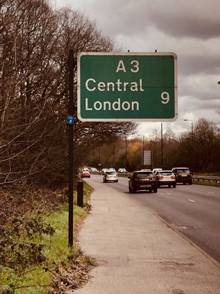
For a moment, it seemed impossible, and perhaps even futile... Who was I kidding? This was futile, but it was my quest and only I could curtail it. I couldn't brook the imposition of failure from outside, even in truth I'd perhaps overestimated my range here. I felt like I'd been walking for miles, but the indirect geography of the A3 meant I was still miles from my goal. In its modern form this is a polite road, twisted around communities and tunnelling under areas of scientific interest and beauty. The old road was more direct, unquestioningly serving the need to link the Naval stronghold at Portsmouth with London since Tudor times. Now that I was back on the former route, things would perhaps feel more direct? Lost in contemplation of the long walk still ahead, I began the descent into the Wandle Valley and soon encountered familiar terrain as the South Circular joined my route. I recalled feeling cowed by distance on that walk too and took some comfort from knowing that I'd managed that trek well enough. As I descended into Wandsworth, the sun broke through once again and the view over the valley opened before me. I felt somewhat restored, and able to push on despite my misgivings. My descent of West Hill led me by the Royal Hospital for Neuro-disability, an internationally renowned centre for the treatment of acquired brain injury. Occupying Melrose Hall, a former private dwelling, since 1863 the facility was established under the blunt and un-euphemistic Victorian name of the 'Hospital for Incurables', and has received patronage from Dickens, Betjeman and Hardy among the usual cast of royals and philanthropists. The impressive facade of the original house glowed in the sunshine, with its sympathetically added, rather grand projecting wings standing proudly against the sluggish stop-start traffic which irritably progressed towards the centre of Wandsworth, no choice but to convene on this single, old road into town. I savoured the descent as a pedestrian: slowly emerging into the busy town centre, now mercifully emerging from months of building works which had choked the streets and masked the river from view. Now, at last, the new waterside housing blocks were complete and the view towards the Thames was once again opened up. Granted it was much sanitised, with new planting and pedestrian priority the main improvements, but it was odd not to see the sluggish brown waters lapping against the muddy banks under the shadow of the working brewery. This development had not been without challenges to retain the character of former site, but the new buildings were anodyne and artless while of course wonderfully situated, enclosing private gardens and riverside terraces. Also inevitably the new area was a 'quarter' - the perennial Estate Agent's vernacular for such reclaimed sites. The Ram Brewery's main buildings still stood - now home to '14 unique apartments' - but the distinctive warm air and tang of fermentation on the breeze was gone. Wandsworth however, appeared to go from strength to strength, the shopping centre teeming with life and the seemingly ever-present street food market wafting new aromas across the river. I lingered long enough to spy a couple from one of the blocks staring silently into the Wandle, almost trying to puzzle out why their expensive apartment had been anchored next to these ancient, muddy banks? It was time to climb out of the valley and head for town, once again passing the impressive civic buildings which housed the Borough Council, and the near-forgotten Huguenot Burial Ground at Mount Nod.
Much of my route for the next leg of the journey was familiar from walking around the South Circular. The A3 and the A205 are uncomfortable partners here, both busy routes squeezed into a gyratory which wheels around Clapham Common, spinning traffic off towards the south-western suburbs. The Common basked in the afternoon sun, the locals coaxed out to lounge or walk - one of the few things to do here which didn't seem to cost money. I noticed a trend I'd spotted countless times around the fringe of the city: young couples walking in a simulacrum of the historic promenade. Being seen out in the public green-spaces of London is an often classless but rarely costless activity, and there was evidence that a great deal had been spent on wearing just the right gear: North Face jackets zipped to the neck with a scarf against the still-biting March breezes, aviator sunglasses mirroring the traffic-lights back at passers-by. I outpaced these couples as they sauntered, largely indifferent to other passers-by and with what little I gleaned of their private conversations they appeared more focused on minor friendship squabbles, petty work dilemmas or social media indiscretions. These couples appeared to be in arrested adolescence: functioning members of society engaged in presumably valuable employment, but trapped on the very edge of adulthood, perpetually waiting for the right time to take the leap. In fairness, the rest of us were hardly helping them, and a little flurry of discarded UKIP leaflets flapping around the pavement in the breeze full of ill-informed bile reminded me that the current climate would make anyone think twice about being part of this mess. The Common remained timeless though - surrounded by grand houses which had housed generations of comfortable but radical types and flanked by streets full of fashionable eating and drinking places. Wandsworth evaporated into Lambeth, and I had a brief but misleading sense that I was nearing my goal. There was a distinct shift into Inner London here, and the squashed cathedral-like dome of Clapham Common Underground Station kicked off a long, busy High Street of nudging buses and slow traffic which seemed remote from the high-speed clamour of the A3 out in Surrey.
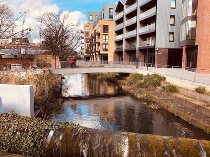
With the shift to inner London came a greater number of people to slalom around. While Wandsworth had prepared me somewhat for the volume of humanity, and the steady flow of pedestrians along the Common had indicated the ambling pace most of the people I now encountered would match, I hadn't been ready for the combination: a slow-moving crowd of people picking over the offer of the long strand of restaurants and bars. Clapham had varied in its fortunes over the years, moving from exclusive rural retreat to fashionable suburb, then for a while regressing into shabby, distressed city-fringe bedsit land. In the meantime it had become the byword for all that was unsurprising and reasonable - the commuter on the eponymous 'Clapham omnibus' riding the network in smug certainty of his eminent sensibleness. But now Clapham was shifting up again, and it was clear where the slow-moving promenaders I'd overtaken were heading. Being seen hereabouts was as important as being here, and wherever there was an opportunity to sit outdoors on the pavement, those who could afford it had taken it up while those who couldn't slunk by absorbing the vape clouds and reflected glory. The oldest suburban traditions held fast: if you couldn't be with the right people, be near them:
The great number of insignificant People who are by no means fit for the better sort of Conversation, and yet have an impertinent Ambition of appearing with those to whom they are not welcome.'The Spectator, No. 24 - March 1711
The bustling string of upscale establishments had a good run, but it came decisively to an end at the railway overbridge near Clapham High Street station. Overground trains rattled by reassuringly often and there was considerable foot traffic between the station and the nearby tube entrance, but otherwise, my surroundings became suddenly drab and downbeat. Almost reassuringly so, and I confess to feeling instantly better fitted to circumstances. I'd shambled in from the edge of the city, walking for sweaty and dusty miles and getting progressively less suitable for the kind of company I'd kept for the last mile or so. I was aware that I was frowning and perhaps even muttering irritably to myself as I jostled for space on the pavement among the purposeless amblers out for a stroll. I had no more right to occupy a contested sliver of sidewalk of course, possibly in many ways even less - but I'd convinced myself of a purpose and I wasn't going to be thwarted.
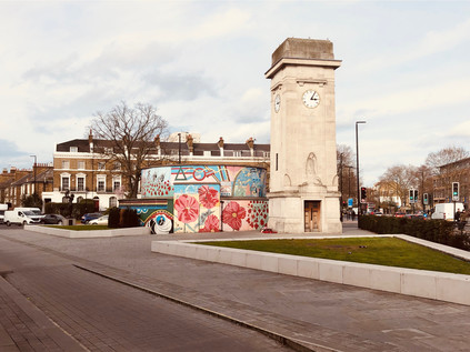
The road straightened and headed unrelentingly towards the city marking a transition into Stockwell which was gentle and surprisingly leafy. The street was lined with the kind of mid-century tenement blocks which had sprung up to resolve the first great housing crisis south of the river as slums were cleared and development edged west along the Thames. These blocks were interspersed with the kind of low-rise estate-as-community projects beloved of the Borough until they were pushed into more drastic action in the late 1950s. Tall buildings along this stretch of the A3 were relatively rare, and where they did rise over the rather traditional street frontage they were solid little point blocks, resolute and robust. The area had a sense of calm, commonplace continuity. There was a sense that important things happened elsewhere. But the cluster of statues and memorials which were grouped around the Underground Station told another story of Stockwell: one which mixed the everyday acts of wartime bravery celebrated on village greens across the country with surprising acts of uncommon heroism. The formal War Memorial is a stocky and austere stone cenotaph, sparsely embossed with delicate carvings and housing a four-faced clock. Beside it, the brick drums of the surface entrance to the deep-level tube tunnels beneath the Northern Line which served as air-raid shelters were decorated with a colourful mural depicting people and events from the history of the area. Local boy turned actor Roger Moore appeared as James Bond beside a scene depicting the arrival of the Empire Windrush which greatly diversified the life of the Borough. Beside them glowered Vincent Van Gogh who lived nearby in Hackford Road while working as a London agent for art dealers Goupil & Cie. Alongside these better-known local luminaries, however, was recorded the little-known story of Violette Szabo. Raised in France to British and French parents, Szabo returned to South London aged 11 and despite a reportedly 'boyish' athletic streak and quick wit, settled into what was typical work for women of the day in the Oxford Street branch of Woolworths, and the Le Bon Marché department store in Brixton. As part of the early war effort, she worked variously in the Women's Land Army and in munitions factories, meeting her Franco-Hungarian husband Etienne Szabo on Bastille Day in 1940. They were swiftly married as was the wartime custom, and he returned to service in the French Foreign Legion in North Africa. Around this time, Violette was recruited through unknown routes, to the Special Operations Executive, finally completing her training in January 1944. She was to make two missions into occupied France working to support Resistance networks and to disrupt Nazi efforts to quell the Normandy landings. During her second mission, she was captured, turned over to the SS and after an arduous journey east, set to hard labour in Ravensbrück Concentration Camp. Her record of dissent and non-compliance in the camp alongside her continued efforts to buoy the spirits of other prisoners and outspoken commitment to finding a means of escape finally brought a response from the highest authorities of the Third Reich which regarded resistance fighters and undercover operatives as outside the Geneva Convention. Thus, orders were given for Szabo's execution during early February 1945 and aged 23, the woman referred to by Leo Marks as 'A dark-haired slip of mischief' was shot dead. So much of her story as reported emphasises how untypical her qualities were for women of the time - but perhaps the only truly untypical thing about Szabo was her incredible behaviour.
But not all of the memorials clustered around this tiny remaining scrap of Stockwell Common harked back to the impossible horrors of war in foreign lands: some were nearer to home and chillingly closer to now. On 22nd July 2005, Brazillian electrician Jean Charles de Menezes was shot and killed at close range by undercover Metropolitan Police officers - possibly accompanied by members of the Special Forces - pursuing him in the mistaken belief that he was one of the suspects responsible for the bombings in London on 7th July. The confusion, disinformation and collusion to hide the facts of a botched operation which followed the shooting represent some of the darkest days of the Metropolitan Police, and showed an organisation in chaos following the catastrophic assault on the capital and buckling under the strain of the vast operation to track down the perpetrators who were still at large. It also exposed the shocking susceptibility of the modern news media to rumour, supposition and opinion as the chasm-like lack of an official response was filled with variant eye-witness reports, amateur detective work and plain old guesswork. While there was a strong post-incident belief that de Menezes was being smeared in an attempt to justify the extreme force used, it's far more likely that the then largely unchallenged powers of the media were simply extrapolating any rumour into an already complex web of fact, fiction and half-understood intelligence gleaned from sources of varying credibility. Today, the shrine which swiftly grew next to the news kiosk outside the station has taken a more permanent form as a mosaic designed by local artist Mary Edwards in collaboration with Jean Charles' cousin Vivian Figueiredo, and Chrysoula Vardax who had cared for the original shrine. The mural watches over the passing pedestrians on the street, walking safely in the belief that they are protected from the actions of hidden terrorists but reminding us that the very structures that protect us can turn on the innocent in times of horror and doubt. Stockwell feels inconsequential on the surface - another bit of London most of us would be hard pressed to identify, and with no clearly defined beginning or ending - but like almost every suburb it has a narrative buried in the dust of its pavements.
After the surprisingly arresting crossing of Stockwell I entered a zone far more identifiable as London. The road here surfed the boundary of Lambeth and Southwark, and marked a more significant architectural divide: low brick blocks in the London County Council tradition flanking the grand sweep of Surrey Cricket Club's ground at The Oval to the north, while high-rise towers of concrete loomed from the south. South London expanded quickly in the 19th century, building on an already established and busy street pattern of poor quality homes nearer the river, where burgeoning industries needed a supply of workers. The clearance of slums wasn't swift, and despite efforts to improve conditions between the wars, the drive to provide a sufficient quantity and quality of housing only really found its feet after 1945 when many thousands of homes were already lost. This meant that the need was urgent: a dizzying array of system-built schemes, experimental designs and one-off projects began to crop-up in the southern boroughs. Young, modern-minded architects who would struggle to find commissions in the fairly stuffy pre-war boroughs were now pressed into urgent service, their most unusual ideas fine provided the numbers stacked up. In Lambeth and Southwark this resulted in clusters of redevelopment around the areas worst affected by bombing or where slum clearance left the most gaping holes in the infrastructure. It also made for accidental grace in utility, with the sweeping concrete spans of Stockwell Bus Garage just a brief detour away from the road. The A3 now ebbed and flowed from traffic-light to traffic-light, slowly pushing traffic further into the heart of London. Alongside the road, with their roots buried in the backstreets sprouted a crop of towers apparently built from a crazy tumble of balconies stacked atop each other. In fact, balconies seemed quite the thing here. Not for Southwark were the sleek, clean lines of Le Corbusier or the cliff-like slabs which were being cranked out through Laing's Jespersen System. Ted Hollamby's Pinter, Arden and Beckett Houses protruded like off-white fangs, their irregular sided profiles casting uncanny shadows over the neighbourhood. Meanwhile, another Hollamby-led high-rise scheme at Holland Rise House included the same curious buckled fascia with waves of concrete balconies cascading down the tall tower, but in the original pebbledashed raw concrete and with a weathered exterior looked a rather grimmer proposition. Ted Hollamby led the charge towards high-rise living in Lambeth, overseeing its transition following the reorganisation of London government in 1965 and continuing to build in the unusual style seen here. Hollamby continued to work in Lambeth until 1980s when the Labour-led Borough's policies finally drove him into the private sector, largely against his socialist principles. There he worked to secure the redevelopment of the Isle of Dogs and campaigned for the building of the Docklands Light Railway. Hollamby left the role of Chief Planner and Architect of the LDDC in 1985, concerned about the direction of the second phase and particularly the Canary Wharf project. He died in 1999 at William Morris' Red House in Bexleyheath, a property he and his wife had assisted in saving from decay decades earlier. Looking ahead, the shining, modern towers of a future city at Elephant and Castle were beginning to in the shimmering sunshine of the advancing afternoon, and given his later work for the market it would have been interesting to know Ted Hollamby's thoughts on modern London and its precarious housing situation?
Most often referred to simply as 'The Elephant' this place, while feeling decidedly modern, has a rather more distant origin. There was an already long-established crossing of ways here by 1641 when John Flaxman built a forge to serve passing traffic. A tavern followed, and its location at the nexus of routes between Kent, the South Coast and London made it a popular place to pause but eventually a fashionable outpost in its own right. By the turn of the 20th century, both the railway and the Underground had echoed this ancient pattern and built a place of interchange at Elephant and Castle. Unlike the busy circuses of the North, this South London hub was a little more lawless and ungoverned continuing the long South Bank tradition which had seen it noted for bawdy theatres, licentiousness and bear-baiting. When the motorcar arrived, the Elephant became a whirling, impossible-to-fathom circus of routes. Local traffic vyed with long-distance routes, and the pedestrian was relegated to a supporting role in the drama of the junction. Then the war came, and it landed hard on this important spot. The historic fabric of the area was almost entirely destroyed in the Blitz leaving great need of housing, but in the eyes of reform-minded borough planners, a great opportunity too. The re-development of Elephant and Castle is not an entirely happy story, but it has achieved one of the goals of the planners: it has maintained a sense of local community. It largely did this by creating vast estates, snaking away into the suburbs which were capable of housing almost all of those displaced by the bombing. The huge concrete wall of the now demolished Heygate Estate, penetrated only via the circuitous ramps and walkways which created a haven for those who wanted to lose or become lost may have presented huge social challenges to the authorities, but it also meant that families who identified as South East Londoners remained in the city and weren't decanted to the fringes. Around the junction though, this made for a strange hotch-potch of schemes washing up against the tide of traffic, dominated by the currently part-demolished anachronism of the Shopping Centre. A modern precinct buried under residential towers, this local commercial hub had managed to remain a part of the fabric of the area despite never really attracting big name stores. Now it was part-deleted, the plastic cladding which had artificially aged the structure gone, but the period lettering proclaiming its purpose still intact above the ill-fitting pagoda entrance. Inside, I could imagine the smell of disinfectant and the creak of a fixed plastic chair in the Wimpy Bar. Around the stricken and soon to be revitalised shopping centre the ages of Elephant unravelled: the shining oxblood tiles of Leslie Green's 1906 Bakerloo Line station faced-off against the difficult-to-like fang of Strata SE1 finished in 2010, with its tapered roofline supporting three apparently non-functional wind turbines. The classical columns of the Metropolitan Tabernacle meanwhile, were offset by Metro Central Heights - formerly the Department of Health offices, when built known as Alexander Fleming House. This clean, functional set of blocks was an early London commission for Ernö Goldfinger, setting out his stall and predicting his future clustering of high- and low-rise blocks, but succumbing to a reputation for 'sick building syndrome' which saw the Civil Servants move on and eventually, a award-winning future as a residential block. Finally, the off-kilter slab of Perronet House occupied a windswept corner: designed by Sir Roger Walters to offer split level 'scissor flats' with views from both levels, this block was the focus of a movement of guerilla gardeners during the late 2000s. Centring on activist Richard Reynolds, their activities in beautifying the Elephant long predate current schemes to improve the area. And what of those schemes? The swirling roundabout of traffic has been 'peninsularised' into a freer-flowing inverted question-mark, with the A3 weaving through it and not-quite-circling the electricity substation which doubles as a monument to Michael Faraday, born nearby on Newington Butts. As I tracked the road around, grabbing my hat to stop it being swept away by the wind gusting across the expanse of featureless but tidy new public realm, I thought about my first visit to this area when attending a training course for work in around 2005. Descending from the grimly dilapidated station and hurrying by the overbearing slabs of the Heygate Estate, we scuttled into a spartan and rather eerie budget hotel for the night, emerging only to eat an overpriced Indian meal before bunkering down for an hour or so in The Rockingham Arms - a frankly terrifying local Wetherspoons pub. I hadn't realised back then that this grim bolthole, selected to delay my return to an equally unedifying hotel, was a little corner of a Goldfinger development nor that it was named for a geological feature which would come to intrigue me years later. In the bright sunshine of the afternoon which bounced off the metal and glass of new towers of unaffordable housing, it didn't seem quite as forbidding perhaps? Whether the Elephant would retain its character and identity or whether the rather curious malaise which seemed to scupper every change would prevail, remained to be seen.
Unreal City,
Under the brown fog of a winter dawn,
A crowd flowed over London Bridge, so many
I had not thought death had undone so many.
Sighs, short and infrequent, were exhaled,
And each man fixed his eyes before his feet.
T.S. Eliot - The Waste Land, 1922
Still with Eliot in mind when I touched down in the City of London at last, I turned west and headed along King William Street towards St. Mary Woolnoth. This strange, unchristian edifice had long fascinated me and had drawn me east when I still felt that this zone was beyond the pale. Much of my long walk into London along the A3 had been in areas I'd felt were similarly alien at one time: the ungoverned precincts of grubby, ancient Southwark fell first - the past just too alluring to avoid them. Then the eternally morose, forever embattled zone of Elephant and Castle with its roots in deepest prehistory. Finally, the suburban banality of edgeland Surrey - quiet and unremarkable on the surface, but with unexpected stories hidden behind its net curtains. The A3 had promised little beyond a good long walk, but it had delivered far more than I expected. Of all the roads I'd walk as part of this exercise, it was the one I'd encountered least, but may be the one I'd remember longest. As I finally took the pressure of my aching soles in a long-familiar coffee shop I'd already begun to delve into the stories twined inextricably around the oddities I'd discovered. The A3 was unexpected - a route of anomalies - architectural, geological and societal.
You can find more pictures from the walk here.
London Ordinal: The A2 - A Spark In Your Veins
Posted in London on Saturday 2nd February 2019 at 11:02pm
I'll start at the end... I'm in the same coffee shop which I headed for at the end of my last walk. An old haunt, a staging post on the way back west after conferences in Bloomsbury or casing the City, worrying about appearing on too many CCTV feeds. I've gravitated here repeatedly over the years because there is something comforting about being above the outflow of the River Fleet, at the end of a mysterious valley which was part of the reason I began to walk around London. It's quiet here again, I sip coffee and write, my feet buzzing with the heat of a walk completed, my calf muscles occasionally tightening unexpectedly as they relax from their exertions. When I set out on this new project, inspired by a return to the road which was in some ways unexpected, it had seemed like a simple enough proposition to walk into London from five different directions, governed only by the vagaries of the 1922 road numbering system. The spider of primary routes out of the city was strange and compelling to me - the roads struck definite, carefully defined courses from the suburbs, but blundered to indistinct ends in the centre of things. Road numbers weren't important in the heart of the old City. Destinations were close at hand: Holborn, Shoreditch, Angel. London looked inwards. It was miles out of town before the A1 gave up its first sign to 'The NORTH'. I'd also surprised myself by obeying the correct order: today I'd headed out to the edge of Kent to walk the A2 from the boundary to the centre. I realised that this locked me into an expectation of compliance with my own rules, and I somehow knew I was likely to follow the preordained pattern: walking might be an act of revolution, but I was no revolutionary. The familiar trip out over the rooftops of London Bridge towards the suburbs was relaxing and almost beautiful with the remainder of snowfall from last week lingering in sheltered spots. I'd dressed for the weather I didn't want to find, but hoped for the bright, cold day predicted. Crossing the Thames in a light flurry of powdery snow didn't bode well, however. I tightened my scarf for the walk ahead.
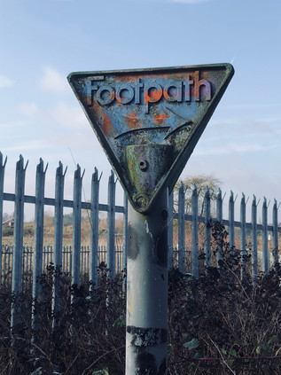
I stepped off the train onto a slushy, slippery platform at Crayford. The landscape felt familiar but was changed by the perils of the icy pavement, keeping my focus just one step ahead of my feet. I headed over the treacherous footbridge and into the backroads which led south along the railway line. I was looking for the entrance to Braeburn Park and Nature Reserve, an extensive but pleasingly unkempt angle of wilderness between the railway line and the A2 as it meandered in from Kent. I hadn't quite crossed the county boundary today: that lay further back towards Dartford, but I was as close as I could easily get as the A2 between here and Dartford was not for pedestrians. I met it instead at a low bridge over the rails, a tiny and rather forbidding path carved into the embankment and indicated by a heavily redecorated 'Footpath' sign. The area had been sequestered for drainage works, with huge tracts freshly of remediated topsoil strewn across a wide triangle of churned land. Everything screamed 'no entry' and I felt a mixture of mischief and surprise when I strode out rather confidently across the patch to find the path which hugged the railway under the bridge and then climbed to join the angry rush of traffic on the dual carriageway. This was the last chance of escape - from the road, and from my rules. Another path led away south, towards Old Bexley and the valley of the River Cray. But again I stuck to the plan and at the head of the slope found myself edging along a narrow path between the hard shoulder and the parapet of the bridge. It seemed likely that the path alongside the eastbound carriageway was better favoured, but I wanted to walk on this side, at least at first. The path soon parted from the road under a sign telling the most polluting vehicles to leave at the next exit to avoid the Low Emission Zone. Delving steeply down again into a snowy gully, I began to enjoy the challenge of the walk. The sky was brightening and any threat of new snow seemed to be passing. I was alone on the remote path despite being mere inches from thousands of motorists. I felt in my element again. Trudging slushily through the snow, I soon came upon the reason for staying on this side of the road: beneath me, the silvery waters of the River Cray were joined by the smaller River Shuttle at a busy, angular confluence. Both rivers were swollen by melting snow and ice, and their junction glistened through the tangle of wintry branches below. Like all confluences, this felt like a significant moment. It had been hard to walk near the Cray on this part of its journey, and these last metres of the Shuttle were almost entirely inaccessible. Passing over the Cray here linked me to previous endeavours and added another junction to my mental map of these south-eastern reaches of London which had been a relative mystery until recent years. I moved on, crossing the complicated loops of the Black Prince junction, the Shuttle now in an anonymous concrete culvert beside me and relegated to the role of a drainage ditch for the hotel site. The Black Prince was now a chain hotel, its mock Tudor facade fronting a quadrangle of more recent and less showy low brick blocks, ideally situated for the commercial traveller breaking a journey on the road to Kent, though it was unclear how many did so nowadays. Named for a supposed haunting of nearby Hall Place by Edward of Woodstock who rested there on route to war in France, it was also a staging-post in the career of another Edward: the late Prime Minister Heath who bunked here during his campaign to be elected MP for Bexley in 1950. The slip-roads swirled around the faded hotel as I returned to the road with the River Shuttle beside me, for a little while at least. The alignment of the route used the floor of the valley created by this tiny river to give it a flat and broadly straight route west. I stayed close to the rush of traffic, my route varying from slippery, frost covered footpath to a secondary service road serving the decent, large villas which lined the A2. The sun was climbing over my shoulder and the day was shaping up to be remarkably bright given the conditions I'd prepared for. I struck out at a surprisingly brisk clip, enjoying the walk.
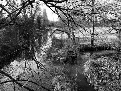
The A2 is a bypass of an ancient route through Kent, which since the 1930s has taken a far more meandering route than the direct, Roman road which ran a little way to the north. The advantage of this southern course was avoiding the steep ascent of Shooters Hill and the passage through the challenging darkness of the woods which blanketed the climb. Between these old and new strategic routes was the broad commuter-belt swathe of Bexleyheath, with its shopping centres and carparks which I'd picked my way across when negotiating Watling Street. I crossed the current route at a footbridge, going against my usual practice: I usually walked with the traffic, preferring the gentle swish of cars passing rather than the unsettling flood of headlights apparently careering towards me. I'd fathomed from very cursory checks that the route might just be easier at the Danson Interchange if I was on this side of the street. In practice, there appeared to be very little to choose with both footpaths requiring a scurry down to the A211 via a staircase, before ascending and reappearing in a narrow alley running across the front of homes otherwise marooned by the highway, widened considerably since building at the cost of their front gardens. The sheltered footpath was still strewn with snow which the sun hadn't yet reached which concealed a carpet of frozen litter tossed from passing cars, and I picked my way along carefully meeting only a postman and an agitated man twitching his way home urgently accompanied by the telltale clinking of a blue carrier bag. I passed the grey reverse sides of huge roadsigns which dwarfed the suburban street furniture around them, casting long shadows in the wintry sunlight and filling the views from the homes along the route. I'd found my stride and I was walking at a fair pace now - but London still felt improbably distant, the long tarmac strap of the A2 slowly unwinding towards the remote city ahead. I surely couldn't reach the centre of things in one walk, could I? Thankfully at least, the house numbers were increasing: there is perhaps nothing so disturbing as realising that the properties alongside a long route are slowly counting down from some currently impossible total, the walk becoming an endurance test. The road continued in its deep trough between the rising woodland of Danson Park and the suburban hinterlands to the south. This clearly wasn't going to make a great story: it was just an arterial route into London, seemingly unremarkable in every sense. There appeared to be few secrets to uncover as the road ploughed onward, arrow-straight and apparently endless, passing the mysteriously named village of Blackfen and pressing on towards Falconwood. The names of these settlements along the route hinted at a less prosaic past buried under the asphalt skin of the road: a history of settlement reaching back into the Bronze Age. At Falconwood my route accidentally diverged from the current A2, threatening instead to follow the line of the 1930s bypass towards the foot of Shooters Hill. I was momentarily wrong-footed by this little nexus of bridges crossing roads and railways, confused by the need to navigate back to the road having barely realised my path was parting from it. A footway through the northern section of Eltham Park led away from the station, but staying true to my purpose I turned to cross the bridge again, passing over the tide of traffic and slithering on the icy pavement which hadn't yet seen sufficient foot traffic to see off the slippery covering of the last few days. As I trudged along a high, narrow causeway above the road I gazed rather enviously across at the tangled trees of Eltham Park North, climbing towards Shepherdleas Wood, and beyond to the peak of Oxleas Wood. A road not unlike this could have put paid to the whole sweep of green I was surveying - indeed there has been an almost indecent interest in ploughing across this ancient woodland and high ground at various points: Ringway 2 would have swept in a little way to the west, while the approach roads for an unbuilt East London Crossing linking Beckton with Thamesmead would have taken an even more direct route through the spot where I was standing. It was hard to understand why this area was so prone to these schemes: the terrain here is far from easy, the rising and falling land between the A2 and the Thames presents challenges of both terrain and contour. Perhaps it stemmed from an unconscious need to tame Shooter's Hill? The old haunt of pagan Britons, murderous thieves, Droogs? The road into the City shone in a surprising burst of sunshine while the dull grey trees, shorn of foliage glowered back at me from the woods to the north. As I surveyed the frosted green carpet of Eltham Park South with distant houses rising from the misty edges of the field, it was easy to be persuaded I'd taken the right path...
Just as the day began to wane and darken, O'er the high hill, which looks with pride or scorn Toward the great city. - Ye who have a spark in Your veins of Cockney spirit, smile or mourn According as you take things well or ill; - Bold Britons, we are now on Shooter's Hill!Lord Byron - Don Juan, 1818-24
Now curving to the north-west, the new course of the A2 continued. Opened in 1985, the Rochester Way Relief Road was a bypass for the original bypass. A desperate attempt to keep the traffic flowing around the congested ventricles of south-east London. Now mired in suburban sprawl the once broad and open arterial route was hemmed in by development and plagued by snarls around junctions with side-roads. Providing a good, straight road into the city which bypassed the slog up the hill had been counterproductive, producing new and heavier flows of traffic along the road in from Kent. The new road provided opportunities for rail too, consolidating the former Eltham Park and Eltham Well Hall stations into a single, modern facility on a raft above the new road. The two stations had been close together - within a few hundred yards of each other - both located on side-streets which weren't close to the local amenities of Well Hall Road. As I skirted the chasm containing both road and railway in a narrow but pleasant strip of landscaped greenery, I passed the site of the former Well Hall station, a fine old building on Westmount Road which had seen better days, but showed signs of regeneration as a pottery shop had opened in one of its flanks. The remaining parts were 'to let', the 'Station Parade' lettering rusting on the gable. It had still fared better than Eltham Park station which had been entirely swept away by the new road. The replacement station was approached by a broad shared cycle and footpath which descended into its wide forecourt. The station was housed in a slightly gloomy but surprisingly large red brick building which had all the hallmarks of British Rail's 1980s penny-pinching despite its unusual size, and which would have of course not been justified anywhere outside of the metropolis in those austere times for the railway network. Buses ticked over between trips in the adjacent forecourt while a train shuttled back towards London, passing the site where an intoxicated driver had derailed a train killing five passengers and himself in the summer of 1972. I exited onto Well Hall Road, a decent selection of shops attracting me in to find sustenance. The area felt pleasantly busy and quietly confident. Up ahead, rising towards the foot of the hill I could see the road converging with the South Circular at a point I'd needed to take a similar comfort break when I made that circumnavigation. I didn't realise then that Well Hall Pleasaunce was so close at hand. This impressively kept range of gardens is on the site of the long-since demolished moated manor house of Well Hall. The last remnant, a fine Tudor barn thought to date from 1523 remains on the grounds, once owned by William Roper and his wife, the daughter of Thomas More. The gardens today were an exercise in careful re-creation: proud black wrought-iron gates adorned with the crest of the former Borough of Woolwich opening onto formal tiers of rosebeds and fountains, surrounded by seats and steps to other parts of the garden. It was remarkably easy to find oneself following a path which led only to a secluded sector of plants and benches, with no way out except to retrace the same route in. Well Hall Pleasaunce did, however, have an open public toilet - a rarity in this corner of London and very much appreciated. Once suitably refreshed and free of the curiously difficult to escape gardens, I turned west again along Edith Nesbit Walk. This rather gloomy path between graffitied gardeners' lock-ups and the concrete retaining walls of the A2 was named for one of the first authors whose name I'd sought out on the spine of a book. After reading The Story of the Treasureseekers in school I began to frequent the library in hope of finding more books by the mysterious E. Nesbit. She was, perhaps, the first author who I felt had treated me seriously and trusted my imagination to deal with a real-world altered by fiction. Her stories may seem trite by modern standards, and many of the tropes - most especially the group of self-reliant child protagonists cut adrift in an adult world - have been reinterpreted endlessly by children's authors in the century or since she wrote. But as a bookish child lacking friends in the late 1970s, I found an escape in these stories of magical realism through which I can track a lineage to my reading today. Even now there is always a journey, always an engagement with a bewilderingly altered world. Walking this cycle path beside the elevated road, gaining on another familiar junction with the South Circular, I felt like I was in a unexpected little adventure of which perhaps Nesbit would have approved?
Once across the psychological but largely inconsequential barrier of the South Circular, the geometry of the A2 began to change. The road here was of modern construction, cutting across the flank of Kidbrooke on a dead-straight alignment until it reached the village where it bucked and reared, suddenly turning northwards. I navigated the footpath which hugged its eastern side, dipping down into a green tunnel where underpasses linked the venerable settlement of Kidbrooke with the remains of its once-proud village green. I've written before about this rather forlorn corner - one of the few places where the brave but foolhardy plans for a city encircled by motorways actually came to pass. The Ringways haunt my suburban walks. Their absence is coded into the blighted strands of property and the convoluted junctions where lesser tributaries take up the slack of a road which could once have been. Modern wisdom counsels against the cruel concrete lanes which would have torn through now gentrified Victorian suburbs, and it's fair to say that life alongside the elevated carriageways of Ringway 2 which would have formed a complex, swirling junction here would have been unutterably grim as traffic levels swiftly exceeded predictions. But as an enthusiast, it's impossible not to wonder how this might have changed the edges of the city? As I passed under the road once again, surfacing close to a spot I'd passed while on my largely aimless walk towards Shooter's Hill last summer, I realised that this was still a nexus of routes. Up ahead at The Sun In The Sands, the ancient Roman route to Dover and its two attempts at a modern bypass converged. First the chasm of concrete carrying the current A2 was crossed by Rochester Way, its early 20th century arterial cousin, and then at a spot marked by vast flickering electronic billboards set against a grey sky, the ancient Watling Street plodded in from the east. Following the traffic, I took climbed slip-road to the west, leaving the main road to continue as the Blackwall Tunnel Approach Road as the spindly pylons of the O2 peeked above the range of new development which cluttered the horizon. The battered but extant public house from which the junction took its name still stood, a traffic-smeared presence across the highway. The sunlight which had temporarily slipped behind low, snow-bearing clouds began to filter through the crystal atmosphere of the wintry afternoon. The traffic turning west shuddered almost immediately to a halt while I shuffled by, my feet starting to drag a little as the A2 was summarily demoted from a motorway-standard road to a townhouse-lined high road. Up ahead, the view to the south opened out across the broad and misty expanse of Blackheath. Shafts of sunlight pierced the clouds, picking out the tiled roofline and church spires of the village which clustered around the railway station. The traffic progressed sluggishly beside me, occasionally surging forward before stopping again - the occupants of various vehicles becoming embarrassingly familiar as we gained on each other repeatedly. There was, for the first time since I set out from Crayford, more human traffic too. Couples wandered by, deep in conversation and wrapped for the cold. Cars decanted children for birthday parties. The heath was flecked with walkers and tourists heading for the sights of Greenwich. I'd passed an invisible boundary into Inner London - a slippery entity to define in official terms, but in my experience it was simple: it was the part of the city where it wasn't strange to be found walking.
It was hard not to be charmed by the passage across Blackheath. The cold, bright afternoon was perfect weather for walking here, and the clouds which were shifting gradually southwards made for a dramatic backdrop. To the north, the land fell steeply away towards Greenwich and the Thames, with the classical facade of The Rangers House incongruously facing down the distant silhouettes of the Vanbrugh Estate. The house was built around 1723 for Vice-Admiral Francis Hosier during his remarkably youthful ascent through the ranks of the Royal Navy. In 1816, the house was first used as the home of the Ranger of Greenwich Park, its first inhabitant thus being Army reformer and imperial campaigner Sir Garnet Wolseley, the model for the 'modern Major-General' immortalised by Gilbert and Sullivan. From beyond the river, the caps of the shimmering silver towers on the Isle of Dogs radiated light back towards me. The road narrowed and twisted along older lines still, descending Blackheath Hill into the valley of the River Ravensbourne. I plodded on down the hill, heading towards the Thames - a relatively nearby prospect now, and in truth despite my land-bound route into London, it had never been far away. There was evidence of decay here in the windowless holes above closed shops and ageing signs offering the once-revolutionary 'Internet Access' - but there was rebirth too. Near the point where the snaking elevation of the DLR twisted around the sluggish convulsions of Deptford Creek, new towers were rising from the flat bottom of the alluvial valley with the obligatory empty retail unit at ground-level to create the all-important 'mixed-use' planning designation. There was a sense of the maritime here too though, a rougher and saltier edge to the estuarial accents yelling religious messages across the pavement in Deptford High Street. So much had changed, but so much hadn't for centuries. Just streets away Christopher Marlowe had met his end for 'the utterance of divers malicious words' - and with the resurgent tide of knife crime now dogging the city, perhaps London was again reverting to type? Deptford felt like a haven of normality though: closed pubs promised reopening, and old buildings found new purposes. The tall Victorian blocks which clustered along the A2 were faded and soot-marked, but they felt like a suburb of London should. The temptation to linger was strong, but the road had a way to go before it ended... At least I thought so - because yet again I realised I didn't really know where it ended. I flicked up the map on my screen, tracing the green line in from Kent, through Greenwich to Deptford, and then to where? The numbers disappeared in the tangle of Central London, the destination more important than the detail. I struck out along the long, shallow curve between New Cross and New Cross Gate - a vague sense of familiarity from a brief and anxious trot between railway stations once before, and recognition of a vast Sainsburys megastore where I'd bought one of the last few Mother's Day cards I'd ever send. The area felt vibrant and busy now, largely due to the presence of Goldsmith's in a string of buildings along the southern side of the road. In truth, was perhaps the A2's last desperate grasp for relevance. Beyond New Cross, the road managed to skirt the settlements which grew along the artery into London: Peckham lay entirely to the south, beyond the queasily cantilevered overhang of its modern library, Walworth straddled the road to Camberwell at the other extremity of Burgess Park. The roads in the south defied logic - those which would seem most important or deluged with traffic playing second fiddle to a tissue of capillary routes fanning between them. The traffic here ran between the suburbs rather than along the spokes of the city. The Old Kent Road was a drab, transient strip-mall of the kind frequently found in the United States. Little bursts of commercial activity stalled quickly, once busy shopfronts turned into evangelical missions and churches. The retail hangars arrived early in this quarter, empty lots being snapped up by B&Q, Homebase and Staples in early red-brick incarnations dating from the 1980s and 1990s. Drive-through takeaways now symbiotically populated their carparks. On the pavement, a string of Southwark Council funded advertising totems implored passers-by to sign the petition to get the Bakerloo Line extended along the Old Kent Road on route to Lewisham. There were, of course, counter proposals to ensure it came nowhere near the cursed tarmac of the A2. I walked a marginal zone, between the ambitiously devout Holy Ghost Zone and the scrapyards, alongside the vast flank of warehouse-sized DIY stores to the string of backstreet newsagents which inexplicably found themselves fronting the major route. It was unedifying walking: an ill wind blew along the road, almost taking my cap back to Kent. I switched it for heavier woolen headgear, not yet ready to let the chill of February into my skull. My feet dragged - and I was unsure if it was the long walk in from Crayford or the resistant drag of the gloomy route? This road had almost killed film-maker Andrew Kötting, his lost days and recovery from a motorcycle accident near here providing the unifying narrative of Iain Sinclair's London Overground.
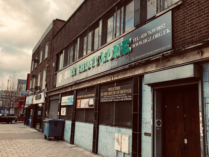
And then, the road finally gave up... At Bricklayers Arms, the carriageway parted and a concrete ramp slung traffic high above the surrounding terraces and the patch of green in the middle of the gyratory. The dominant flow was south-west to south-east, avoiding the city entirely at least from this awkward angle. Vehicles sprinted towards Brixton and Elephant & Castle, leaving the road into the City oddly quiet. I circled the junction, heading for the A2 exit which was now barely signposted and swiftly dwindled to a two-lane avenue between trees, quiet and flanked by London County Council era public housing and more recent student accommodation. For the first time in miles, perhaps even in the months since the last walk of the summer, I could hear birdsong above. The afternoon glow of the golden hour was descending on South London and the brief wintry blast of the last few days appeared to have been entirely dispelled save for a biting wind from the river. The A2 here was a spent force, only good for pilgrims making the last drag of bloodied feet towards the gabled inns of The Borough. I made my own last drag towards the crossroads where St. George The Martyr surveyed the junction of the A2 and the A3. At the moment of contact, where my route finally ended, the bells struck three - a mocking rejoinder, and a reminder that this project was barely even begun. The road in from the South West seemed long and impossible, longer even than today's slog from the icy wastes of Crayford into the gloomy, cramped terraces of Southwark. Here, perhaps more than anywhere along this ancient route in from Dover and Canterbury it was possible to picture highwaymen rubbing shoulders with penitents and pilgrims. Perhaps it was the shuffling tourists seeking the wineries and street food vendors of the market, or the heads-down weekend commuters dragging their tired feet towards London Bridge station? In the shadow of The Shard, always more impressive from a distance than beside its awkward, glassy bulk, I turned away from the A2 and faced the City at last.
My last few yards were challenging but rewarding: though my feet begged for a pause, I couldn't recall ever crossing Southwark Bridge before. The quiet route over the river was surprisingly narrow and almost entirely free of pedestrian traffic. It has always been the quietest of all the crossings, based on a flawed endeavour it was opened as a public toll bridge in 1819 when the neighbouring London and Blackfriars Bridges were already free of charge. By 1864 the owning company was bankrupt and the crossing transferred to Bridge House Estates and made toll-free. A century after the original opening, the current bridge was built - but the habits of Londoners change slowly and the bridge remains a backwater, often used for filming or as a diversionary route. The Thames gleamed in the last gasp of low sunlight, reflecting the clear, blue skies which had churned with snow and sleet just hours before. I touched down on the north bank, feeling my range anxiety dissipate almost immediately as I zig-zagged along familiar routes to Dowgate Hill and up the Walbrook's shadow-estuary towards Cannon Street station. This walk in from Kent had seemed impossible at times: a long, frozen canyon from the south and east which appeared to have no secrets to give up. However, it had been a surprisingly engaging journey. An unwinding of the onion-layers of London via a precise incision, and a salutary reminder that plans and schemes to permeate the city by new routes rarely ever worked - however hard the planners planned and the builders constructed, the pilgrims would always progress by the oldest of ways into London, patterns unchanged for millennia. Even though it was just their ghosts and I walking the last few yards of the road towards the river, the proud past of the Great Dover Road was undimmed by it's current infirmity. There was a sense that glory lay at the end of the street - whether in the old stones of Canterbury or across the water in a swiftly receding Europe.
A gallery of images from the walk is here.
Lost::MikeGTN
I've had a home on the web for more years than I care to remember, and a few kind souls persuade me it's worth persisting with keeping it updated. This current incarnation of the site is centred around the blog posts which began back in 1999 as 'the daylog' and continued through my travels and tribulations during the following years.
I don't get out and about nearly as much these days, but I do try to record significant events and trips for posterity. You may also have arrived here by following the trail to my former music blog Songs Heard On Fast Trains. That content is preserved here too.
