I realised as I sat on the near-empty Northern Line train, shuddering noisily into the light somewhere in Finchley, that my previous visit to this part of the London had been a very long time ago. In fact my last traversal of this part of the Underground network was before I kept records of such things. In the mid-1990s I'd embarked on a project to cover as much of the Tube as I could - despite a crippling phobia regarding escalators - but this involved nothing more fastidious than marking the lines on a map. Now I was clanking into the quiet terminus at High Barnet once again, with a new project - and this time I was taking careful notes. I recalled at least that I made a dash on foot between High Barnet and New Barnet stations at some point around twenty years ago. It's perhaps no surprise that I don't remember the route in detail, but my abiding impression is of surprise at how ordinary and suburban things felt. How oddly short on spectacle things seemed, surfacing at last after delving into the earth just a few miles south in the middle of all things. I also remember that what appeared a thumbnail-width smudge of yellow between the stations on the map was in fact a fairly long walk. Outside those specially amplified 'Central Area' pages of the A-Z, scale is elusive and strange, London is elastic. I hadn't learned the over-used term 'range anxiety' then, but I felt it acutely. I need not have worried - I was imposing my ever-invasive provincial fear of 'missing the train' on a route with a far, far better service than a young man from the sticks could even imagine. My other conclusion however stands two decades later: there are just too many Barnets. High Barnet, which is - it seems interchangeably - Chipping Barnet sits high on a ridge of land in the midst of this confusion, with Barnet Gate out to the west in the Dollis Valley and East Barnet - perhaps predictably - to the east in the valley of Pymmes Brook. Between the two is the decidedly misnamed New Barnet. South of all of this, nearer to Southgate in fact, is the outpost of Friern Barnet. I can only wonder what horrors this area must have wrought on the early life of Keith Joseph who was Minister of State for Housing and Local Government at the time of the creation of new London boroughs. Despite a local committee coming up with modern, fresh and non-partisan names such as "Northgate" or "Northern Heights", Joseph - requiring as noted by The Times "the wisdom of Solomon" in this matter - opted simply to name the new entity Barnet. Keith Joseph's ideas appear to have staying power - he of course went on to play a part in the creation of Thatcherism which still exerts its peculiar influence on Britain today - and Barnet is still a rather unconvincing meta-place - an artificially constructed borough which contains many communities with competing and contesting identities. Like Barnet, Joseph was never much in the limelight, content to be the supporting act. He is, I suspect, one of the local spirits of place here.
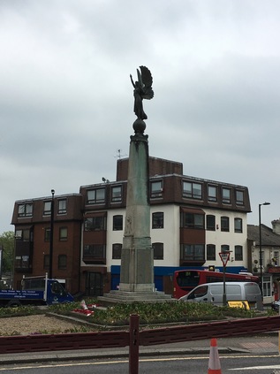
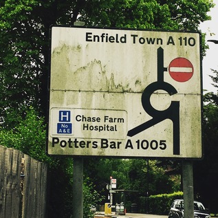
Early indications for today's excursion aren't promising - I head out of High Barnet station and immediately realise that I should have crossed the busy A1000 sooner. The footpath runs out and I'm forced to make an ungainly crossing by a glaring bus driver who seems unable to pass by and insists on allowing me to go ahead of him. I'm wearing brand new walking boots too, and while they're undeniably comfortable, I'm conscious that I'm about to walk a good distance in them for the first time. Not used to a good thickness of sole beneath me, I frequently misstep at first, bringing my left foot to a scrunching halt while the rest of me continues unabated. It's not pretty, I'm sure, for the bus full of people who just want to escape Barnet but are treated to this spectacle. As I arrive safely on the western side of the road I'm gladdened to see the view across the Dollis Valley spreading out to the west. Lush and green, punctured by red brick houses and clusters of apartments, it is also tantalisingly unwalked. This is the edge of the quadrants - London's great divide - where the rivers turn east or west away from this high ridge. A misty haze beyond Barnet indicates the edge of London - and helps to contextualise just how high up I am here. Today will literally have its ups and downs as I head east from ridge to ridge. If I'm serious about this project, then I'll need to get used to clambering up and down the valleys of the various brooks and rivers I've walked before, and potentially many I haven't. A little south of the station, as the Northern Line passes overhead on route back to the City, the object of my excursion shows up for the first time. It does so on an amateurish road sign which uses the wrong font and a frankly elephantine arrow to guide us east along the A110 for East Barnet, Cockfosters and Enfield Town. This is where my walk starts in earnest. After ceremonially popping into the local Tesco Metro which faces up across the street from the impressive Everyman Cinema at the junction, I stride off into the northern suburbs. The A110 has cropped up in several of my previous walks, and I'm curious to see how familiar it feels as it links them together. It's clear that I definitely have no abiding memory of this stretch - but it's equally plain why this feels hazy. The rank of pleasant brick villas which fringe the street is broken at intervals by the flapping white dust-sheeting which hides redevelopment. Each masked building is slowly becoming a small but luxurious block of apartments on the footprint of a former large family home. Where these new builds are complete, the pattern is clear - curving balconies fringed in bright metal bow out towards the road, and impressively secure gated entries protect the ground floor from interlopers. The street is busy with through traffic while postmen and delivery drivers weave between them making regular stops to pitch Amazon parcels into capacious letterboxes. A gentle descent begins, and I reach New Barnet which is heralded by Newbury Trent's angel of peace sculpture topping the war memorial. The junction surrounding the angel is a churn of roadworks and traffic, and I'm forced to almost completely circumnavigate the statue to get across the street. The angel, a weird mixture of classical and modern design, walks serenely to the west, her eyes forward and hands raised, holding a feather aloft. It feels strangely like she's begging to be lifted out of the chaos and fume around her. The rest of New Barnet is less modern and certainly doesn't feel new at all. In fact, considering the surrounding suburban affluence I'm a little shocked at the down-at-heel feel of some of the crumbling Victorian shop fronts which I pass after the low bridge under the line to Kings Cross. My route turns south here and begins to descend more markedly to the east. A little further on, the A110 turns left at an entirely unmarked junction to avoid East Barnet Village. I've successfully avoided East Barnet before, skirting its edge when I walked Pymmes Brook - and I soon realise with some surprise that I'm approaching the point the brook passes under the appropriately named Brookhill Road. This feeling of recognition in an otherwise strange place is a curious one - and as I wander by the closed computer shop and car hire facility which I'd vainly hoped held at least a chance of refreshments on my last walk, I realised that the delights of East Barnet Village such as they were, had been lurking just a street away. I also recalled that while last time I'd been relieved to turn south along the brook, this time I'd have to climb Cat Hill which was just as steep as I'd remembered. Again, at the junction there was little recognition of my route - except for the rather unusual inclusion of 'A110' beside the street names. I began the climb and surprised myself by not feeling exhausted within seconds. Perhaps this walking had some longer term benefits after all?
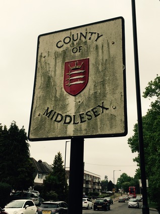
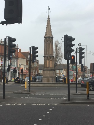
At the top of Cat Hill I stood on another ridge - this time dividing the valleys of Pymmes Brook and Salmons Brook, two minor but significant watercourse here in the north. Still a little surprised by my improved stamina, I pressed on over the ridge and onto the tongue of land which separates the valleys. Across the street, a residential cul-de-sac intriguingly called Daneland promised misty views over the falling ground south towards the distant city. With the low cloud and overcast skies it wasn't possible to see far so I pressed on, pleased to be on relatively level ground. A little way to the east, the A110 faced the most important junction I'd crossed so far, meeting the A111 at a sizeable roundabout. From here, routes reached north to the M25 and south-east towards the North Circular, with the journey onwards into Oakwood perhaps the least important of the four ways. As I navigated my way around the circle of traffic, I remembered that this junction had until relatively recently been decked out in a full set of old style pre-Worboys direction signage. My early obsession with British roadsigns had begun when these relics of a prior age of motoring were reasonably common - but sadly, now the rather ordinary modern signs simply indicated my route towards Enfield, five miles hence. There was one signage related surprise to be had though - a little before the roundabout on a pole almost obscured by trees I spotted a sign indicating I would have been passing into the County of Middlesex. The very same boundary changes which had created Barnet had done away with this ancient county which has its roots in the Saxon kingdoms which dominated the south of the British Isles. While other counties had ceded territory to the beast that was Greater London, Middlesex was swallowed entirely by it. The rise and fall I'd walked so far today was once a narrow tongue of Hertfordshire which curved south and east into what had been a proud county in its own right. As I passed into Southgate I had crossed the ancient boundary which was now barely celebrated as the border of Barnet and Enfield. The surest indication was the changed insignia on the green wheelie-bins which lurked at the end of each drive. Middlesex has all but disappeared in the mind of anyone younger than my generation - we at least had the last rites: sending our letters and pictures to children's TV studios with Middlesex postal addresses long after the county had passed into history. That said, this now erased unit of democracy has had its champions, and as I trudged by the stark, modern brick slab of the Church of Christ the King on the perhaps optimistically named Peace Close, I recalled the lines:
Dear Middlesex, dear vanished country friend, Your neighbour, London, killed you in the end.The flame of Middlesex also still burns of course in the painstaking and sometimes torturous research of Nick Papadimitriou. Nick would contend that somewhere along his endless scouring of hedges and retail parks, he has become Middlesex. I was aware of walking in his footsteps often in my northern excursions, and spotting this fragment of tangible history brought his eccentric progress around the northern heights to mind. Perhaps he was out here right now, beating the boundaries? I pressed on into Middlesex, realising I'd be passing entirely through the ghostly tail of the erased county if I managed to complete today's route.Sir John Betjeman, Marble Arch to Edgware, 1968
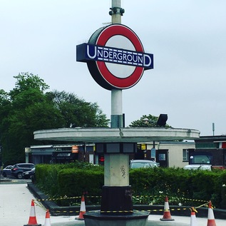
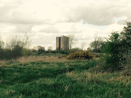
Soon after entering Middlesex I passed the imposing Oakwood Station. The huge brick and glass box designed by Charles Holden seems almost too grand for this once remote outpost on the 1933 extension of the Piccadilly Line. Serving as the line's terminus prior to Cockfosters opening some months later, the line swings north and west through a broad fan of sidings here, which extend almost all the way to the new terminus. For a while though, this fine modern station was an early battleground between the future London Boroughs which abut each other here. It's a convoluted tale - the station being initially named Enfield West despite suggestions including the frankly inflammatory East Barnet. A consolatory (Oakwood) was added to the name later, and so it stood for the next decade or so. Like many of the inter-war extensions to the Underground network the speculatively built suburbs which now surround the station followed the rails slowly, and initially Oakwood stood in isolation on unpeopled land between the two ancient municipal seats of Barnet and Enfield. The spat was finally settled in 1946 in favour of simply 'Oakwood' via the intervention of Southgate Council, who noted their claim on this area. Southgate Council was to pass into history in 1965 along with the other players in the convoluted tale of the station's name, but Oakwood remains simply that - with a tall Underground roundel pierced by a slender spike and set imposingly next to the road. Beyond Oakwood, north of the road, the health club and golf facilities at Trent Park limit the further growth of the suburbs, and after passing the station there is a surprising and uninterrupted view north into the hills of southern Hertfordshire. With the haze beginning to lift the broad sweep of southern England was oddly breathtaking and a remarkable contrast to the suburbs I'd been plodding through. Tempted by the various cafés which lined up alongside the station and its parade of shops, I managed to continue east. With the A110 forming the northern boundary to the suburbs here, I was keen to cross the street and walk on the rural side of the road. I was rewarded with unexpected flashes of green hills and distant woods peeking between the trees and scattered farm buildings. I noted though that there were frequent warnings that this was Private Land which seemed oddly unnecessary. My curiosity was answered a little further ahead by a neat banner hung on a gate to promote Enfield Road Watch. It seems this green fringe is under threat from development. It's easy to see why the locals would want to protect this zone - and equally hard to imagine what more attractive place a speculative developer could find for their new urban extensions than this Underground connected semi-rural haven. Perhaps the modern builders will finish the job begun between the wars - but I hope the locals prevail, just for a little longer at least.
The straight road ahead of me began to delve down into another valley and I could see the higher ground of Enfield Town rising away in the distance, church towers and impressive houses flanking my route ahead. The ridge I'd been walking since East Barnet tapered down into the the catchment of Salmons Brook, bottoming out at World's End where I'd begun my walk along the waterway last winter. I knew this meant a long slow climb up Slades Hill on the other bank of the stream, which I wasn't looking forward to - so I rested a while near the brook, watching traffic zipping down the rollercoaster created by the valley bottom. Eventually I set off again, taking the steady climb again surprisingly in my stride, slowly progressing through the ranks of imposing homes on the outskirts of town. Enfield is a curious place with its own onion-skin layers of development emanating from a busy centre. Once at the top of Slades Hill, the Ridgeway swings north to head out to Potters Bar, and my route gently slopes into town via a long terrace of shops caught in mid gentrification - the ubiquitous Ladbrookes standing next to quaint little organic eateries and just across the street from a Waitrose. There's a pleasant buzz to the slowly emerging town as I cross the idyllic loop of the New River with ducklings skittering around behind their mother, and pass under the railway near Enfield Chase station. I take a moment to pause for coffee in the busy high street near a somewhat upscale street market selling artisanal foodstuffs, probably a world away from the business conducted in the square for centuries before. I notice too that the installation of Britain's first cashpoint is market with a small blue plaque too - and I can imagine based on trade today that it was well used. My last visit to Enfield was early in the morning when the meeting of ways centred on the war memorial was almost entirely deserted - but today the pavement is wedged with shoppers and I'm glad to finally strike out east again, beside the restored and pleasantly reedy old course of the New River towards Southbury. The town gives way to straggling suburbia as the New River turns north to regain its main route, this last stretch not yet restored and little more than a reeking green ditch between ranks of decaying metal siding. There is a haze of traffic in the middle distance as the road approaches the crossing of the A10 - the Great Cambridge Road. A huge leisure complex looms on the northern flank of the carriageway, the building silvery and impenetrable - unless one pays the requisite fees of course - but offering all the refreshment and entertainment you'd need within. The self-contained pleasure centre is served by its own footbridge too, meaning that access can be gained without taking your chances on the busy road crossing - they want to be certain your wallet arrives in one piece of coure. Those of us wanting to pass over the A10 however have to navigate a complex of traffic signals which interrupt six lanes of growling, shuddering vehicles rudely brought to a stand at a red light. It's an uncomfortable intrusion into my walk, which while it has passed along busy streets, hasn't encountered a main arterial like this at all so far. I've been aware of but shielded from London on this cross-route it seems, and here I'm crossing one of its primary gateways - bored motorists gunning their engines waiting either to enter or escape the gravity of the city. I'm an irritation. Why would you walk out here? I'm glad to be over the boundary which the road creates and entering the familiar edgeland scenery of Southbury - vast supermarkets, retail hangars and distant tower blocks. I can feel the magnetic pull of the Lea Valley beyond. This is more my usual kind of place, it seems.
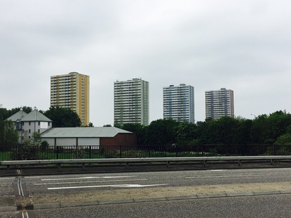
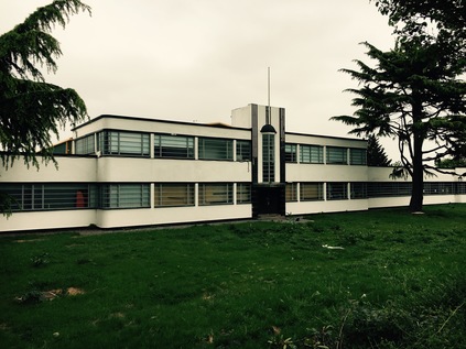
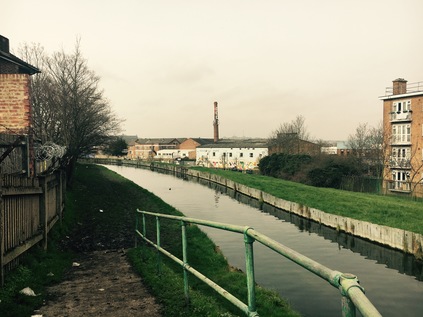
The change in zones is tangible - and almost jarring. At the hump in the road where it heaves over the line to Liverpool Street is the tiny, Victorian red-brick Southbury station, marooned atop the bridge and crowded in by two solid and miserable new-build cubes. The road falls gently away ahead of me as the solid brick terraces of Ponders End close in. Looking to the horizon, a band of green indicates Epping Forest climbing away from me to the east. I try not to feel too elated to see my goal - the land between here and the forest is flat and deceptive, and I'm really only just over half way along my planned route. This long, flat passage into the Lea Valley is oddly tiring. The roadside scenery has been a constant band of retail unit grey for some way, and the dusty carriageway is plagued by too much traffic going far too fast, making the dodge across the valley here to avoid the sluggish progress around the North Circular. Opposite the station is a curious survival - the art deco Ripaults cable factory - a smooth, aerodynamic gem of the type of building which seems to crop up more readily along the western arterials out of the city than here in the east. Now in the care of builders' merchant Travis Perkins, the paintwork is pristine and the building remarkably well-kept. Almost too clean in these dirty, dusty surroundings. The listing of the building clearly helps. Looking around I'm reoriented by the appearance of four dominant tower blocks. I've seen these huge buildings before from the other side of the valley - built to an entirely different scale to the surrounding low-rise light industrial landscape. Curlew, Merlin, Cormorant, Kestrel - the four guardians of Ponders End line up attractively for a gloomy cross river shot, but close up they are more human in appearance if no less impressively massive. Practical, unadorned and straight-sided, their only concession to decor are the coloured panels which run down each block, distinguishing it from its siblings. The alignment from close quarters is tighter and the blocks feel huddled for safety here, rather than the overbearing aspect they posses from the east bank of the Lea. I snap shots from a few angles, enjoying the way the scene changes as I gain ground on the blocks, then slip by them. Suddenly, I'm at a roundabout near Wright's Flour Mill, the old industrial buildings oddly out of scale with their modern surroundings. The signs here encourage walkers and cyclists to head down to the footpath on the Lea Navigation, but I'm determined to stick to my plan - however uninviting the bridge over the river has been made. After negotiating a road sign planted inconveniently in mid-path, I find myself on a narrow pedestrian refuge inside the crash barrier. Ahead of me, the green of the valley sprawls north and south, the ubiquitous pylons ranging left and right. Below, the first branch of the navigation is calm as it winds around a broad meadow in front of a Harvester restaurant named for it. I recall this spot from a previous walk along the river - where the way splits and a substantial loop of water disappears behind the riverside inn. Further to the east I can look back and see the view from a new angle, marvelling at the complexity of the watercourses in the valley. A little further ahead the expansive valley view is gone, and the road enters a deep green chasm between the huge reservoirs. Sheep graze on the banks investing only cursory interest in the solitary walker on this causeway, and seeming to be entirely untroubled by passing vehicles. I almost a little oppressed by the presence of the vast bodies of water above me on both sides. I also feel strangely and conspicuously alone, despite the regular pulse of traffic on the road. The valley never ceases to find new ways to feel strange and unnerving - perhaps one of the reasons I'm drawn back here again and again.
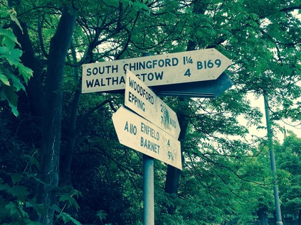
As the reservoir banks taper down to ground level at a knot of complex water-related buildings and pipeworks, I cross the final channel in the tangled web which the Lea weaves along the valley. In doing so I leave the traditional County of Middlesex behind and enter Essex. Except of course I don't - in the post-1965 scheme of things this is Waltham Forest. More accurately it is the foot of Kings Head Hill, a long and steep drag up to the ridge on which Chingford sits, between the valleys of the Lea and the Ching. This is well-marked territory for me, but I've never arrived from this direction and it requires a little orientation before I place myself in relation to previous walks. As I trudge up the hill, spotting the green tump of Pole Hill rising away from me to the north and recalling the wonderful views which it offers, I consider how Chingford has become an unlikely locus for me. It's the kind of place which figures in bad panel-show jokes. If some mildly left-of-centre comedian wants to complain about poor public transport he (and it is, almost unerringly he) will mentioned 'the 8:15 from Chingford'. Whether this train exists, or whether it is peopled by the kind of middle-class conformists he's lampooning is immaterial - by invoking the name Chingford he's conjured an image in even the most provincial of minds. The place is of course far more complex than I ever expected - and while it has plenty of the anonymously similar middle-class housing I'd assumed would be around, it has a tangle of new-Essex bling, a remarkably long history as a forest community and is a surprisingly strong strategic position for exploring the area. At the top of the hill the ways divide around the Church of Saints Peter and Paul and I take the opportunity to rest under some non-standard County of Essex installed fingerpost signs which send me towards Epping and Waltham Cross. The old road into town is a car-free path here, which is busy with all kinds of people, persuaded out by the sun which is now in evidence after a gloomily hazy morning. The sign to Woodford helps me to realise I have a way to go, and I'm surprised to find myself unhappy I can't wander into Chingford and relax for a while before plunging into the forest. Instead I press on along the A110, now a fairly unimportant cross-route which isn't going anywhere too useful just now. Traffic for the M25 has long headed north, and the crossroads at the foot of the hill took the last of the city-bound traffic. You'd only be on this road if you needed to be. The road parts again at the Four Wents - a fine old Essex term for a route or way - and Friday Hill, the southerly route, seems to take the strain leaving the A110 almost deserted except for the occasional speeding BMW. South of here is the remarkably named Pimp Hall Park which I mentally note I must visit at some point. Chingford doesn't end as such - it tapers into leafy suburb, then there is rather suddenly more leaf than suburb. I'm surrounded by a familiar green light and the damp, woodland smell rises from the drying ground. I'm back in Epping Forest. Tantalising paths spin off right and left, delving between trees into gloomy thickets of ancient and largely unmapped woodland. The draw of the forest is remarkably strong. As the road begins a curve to the south, I cross the River Ching and find the pathway I'd used on my winter trek. Whitehall Plain opens to the north, free of frost and mud in the pleasant sunshine - and I can't resist following the path a little way alongside the river. When I'd walked here in January I'd had to stick to the open field as the river path was impassibly sodden and treacherously iced over. Now I could scuff along the forest floor, noting that the unfamiliarly thick, new soles of my boots made me stumble over roots and stones. I was used to my old, worn down pair and was learning to walk in these afresh. It seemed fitting to offer them a first taste of walking in the forest today.
Eventually I returned to the A110 to finish the walk. The last stretch was quiet and leafy, skirting the pleasant grounds of the surprisingly large Bancroft's School and coming to rest at an inconspicuous junction with the A104 heading south into Woodford and Walthamstow. I crossed the busier, wider road and looked back along the A110. There was little to distinguish it as an important route for the many, many Londoners who used it, or for the relief of the more important cross-routes and orbitals which already bear an impossible load of traffic. Does anyone ever need to drive from its convoluted contortions in the west to this rather austere eastern terminus? I suspect not - it is a road used in familiar, everyday parts by people who live along the surprisingly diverse course. It's a rat-run across the valley, a useful dodge to avoid the North Circular, an easy way to get out towards the M25. Today, for me at least, it has plotted a course across the northern edges of London, across ancient Counties, meddling municipalities, and across the undulating valleys rising from the Thames. There are many more of these odd routes to walk - and it appears I may have accepted the challenge...
A gallery of images from the walk is here.
I set out to write a fairly ordinary report on a long, satisfying walk I recently completed - and as the introduction grew, I knew I was in fact writing something else. A justification, a manifesto, or just a project plan perhaps - in any case an explanation of what led me to decide to walk along an uncelebrated North London A-road from somewhere to somewhere else. I didn't feel the need to justify this to anyone except perhaps myself - but I felt the uneasy stirrings of a project forming - and that's always dangerous. So, the ramblings below are the formative musings on London's Other Orbitals. A likely highly irregular series of wanders along the onion-skin layers of byways which encircle the capital, connecting suburbs known only by their imprint on the tube map. Some will be familiar, important byways while others will be little known backwaters. All will likely be equally unlikely candidates for mythologising. That's often the character of outer London, it's sometimes so ordinary that it's surprising...:
On 29th October 1986 a formation of decidedly British motorcars cruised along a broad, empty carriageway near London Colney. The location was symbolic, but secret - an attempt to dodge the attentions of Republican terrorists who threatened public events like this one in that now almost unimaginably tense period. A little later in a nearby tent topped by flags whipped energetically in a fierce crosswind, the Prime Minister appeared to be struggling to stay awake through a long slew of speeches as she sat, alone on a folding chair clutching her trademark handbag. It's perhaps fair to say Margaret Thatcher was off her territory out here. Despite her reputation for creating the conditions which the modern commercial city needed to spiral out of regulatory control and her celebration of the 'car economy' she was never truly of London. The grocers' daughter from Grantham squinted into the late autumn sunshine and delivered her speech from the lectern to a crowd of experts - transport planners, civil engineers - all brown suits and whipped cones of white hair. Some of these people had waited an entire career to see the promise of an orbital road for the capital delivered despite one head-scratching compromise after another being conceded. Others, younger and keener, surveyed its already apparent inadequacy for the job and visibly salivated at the revenue to be gleaned from its inevitable widening and reworking. Thatcher was unusually rattled, self-evidently unsettled by these grand projects which drained public coffers - and while the M25 would go on to be a truly privatised road, this was the end point of a public sector struggle with finance, planning and grassroots activism. Roadbuilding and its detractors were opening up a new battlefront with the government which would stymie their ambitious plans well into the 1990s. But for now at least London had one of its ringways - and for a few more years at least the new-money generation, the retired Essex gangsters and the Eastern European truckers which the Prime Minister had enabled to move out of the silted-up streets of the city and into the pristine greenbelt would prowl slowly around its increasingly tortured carriageways, cursing their progress and addressing the road like it was a living, sentient thing.
Years later, with Thatcher's power dimmed, Iain Sinclair exorcised the M25 by walking its beat and superimposing other orbital projects on its path through the fringes of the urban sprawl - not least the ring of asylums which conveniently spirited the mad, bad and morally lapsed away from the core of the Victorian city. By then the M25 was a recognised margin - the relative weight of events judged by their occurrence within or without its orbit. This was a management of the London problem which would have impressed even the most radical Victorian patriarch. However, the rest of the grand plan hadn't materialised and slowly the urban motorways which had begun to snake towards Central London would themselves withdraw to the cordon of the M25. The road was by definition and nature a compromise - a tangle of repurposed sections of Patrick Abercrombie's four concentric Ringways which in turn had their origin in Lutyens' 1930s ideas for a city of cars. An orbital road wasn't a new idea at all - the North Circular and its poorly thought-out southern cousin had their origins in the 1920s, and the North Orbital Road had long existed in a piecemeal, ever-altering fashion, staggering lazily around Hertfordshire and Middlesex prior to the completion of the M25. But within the ring of grey tarmac lanes which (almost) encircles Greater London, the everyday journeys still need to be made. Not every excursion demands circumnavigation at the margins - and the spiderweb of routes which string between the great 1930s arterial routes and the M25 still exist. These other orbital routes are the capillaries of the city - they take workers home, ferry shoppers to retail parks, allow ambulances to swerve through traffic to London's huge regional hospitals. They are the roads that Londoners, trapped within the orbit of the city, use to move across it rather than around it. I encounter them endlessly on my walks - sometimes well signposted and good quality dual carriageways which scythe across green space, sometimes ungainly dog-legging old routes which convulse around urban centres. But always busy, always going somewhere while their bigger, bolder relative out at the margins goes - well, nowhere at all.
And so, a new project suggests itself. In fact it had already begun with a walk a little while ago along the A503. I'd realised that many of my walks were radial treks from the outskirts of the built up area, through ragged edgelands and into the urban core. In recent times though, as my routes had crossed old paths at unexpected junctions, I'd become curious about the links between these spurs. These are the connections between the villages and towns of London which pulse with life even when the commute has finished for the day. During my walks I'd found sudden bursts of countryside, miniature townscapes crushed into the angle of road junctions and endless parades of local shops, the range of which would provide a sometimes startlingly accurate judgement of the character of an area. In short, I was finding the everyday London which falls between the celebrated highlights and fails to trouble even the most adventurous tour bus itineraries. Like all my ill-advised projects, it started accidentally and the rules would of course be constructed as I progressed. Would I go south of the river? What constitutes a 'route' across the city? Is it imperative that I always end up in South Woodford? I expect all these questions to be answered, those answers revised and any rules broken long before they're made. I also suspect that I'll stray into other zones of interest as my curiosity takes me. Perhaps I'll pick up the walk along the A13 again, or decide it's high time I walked the rivers of the north west quadrant - who can say? But for now, I'll be slotting these treks into the itinerary and, as ever, writing posts here which virtually no-one will read.
See you somewhere between here and there...
It felt like a quite a while since I'd walked beside water...
My journey to London had been sleepy and distracted. Relaxing didn't come easy this morning after a long and trying week, but as I made progress towards the start of my walk, I began to feel a little more alert. The routine was familiar from my attempts to walk the fringes of London: over to Liverpool Street, out to the suburbs, then a bus to the start of my walk - which had seemed to grow increasingly further from civilisation over the months of walking rivers. As I careered around the roadworks outside Romford Station to reach the stop where I'd depart for Collier Row, I realised I'd be passing this very spot later if all went to plan. Even the name Collier Row sounded distinctly unlike London - a strangely northern sounding area, which was in fact a fairly modern nod to ancient charcoal workings near the site. In truth I was feeling a little range anxiety - heading to the very end of the bus routes, to the curious spots on far-flung estates where engines idle and the drivers pull out their newspapers to lay-over until the next service back to town. In the event, I hopped off a stop early - the bus was cresting a rather steep hill which promised a view across the surrounding area, and I didn't want to miss the opportunity to survey the landscape. I was the last passenger off, standing on a dusty corner near a row of bungalows and struggling with my rucksack while the bus trundled away to its terminus. The penultimate passenger shuffled away with her shopping, casting a suspicious glance back at me. I was alone at the top of the hill. Away to the north the low hills of Essex were fringed with woodland. The suburban sprawl simply stopped at the end of the road. A row of off-duty buses lined the narrow street, giving it an air of far more importance than it deserved. To the east and west, the ground rose to envelop this northern extremity of the city. It was time to start walking...
The continuation of the route down the hill became Clockhouse Lane, a mettled track leading to some decidedly unofficial looking dwellings. The yards were littered with vehicles in varying states of repair, and a vastly over-engineered set of ornate but clearly sturdy metal gates blocked the route into the back garden. What it secured, I dared not consider. Beside these houses, a row of industrial premises and breakers' yards filled in the edge of the woodland. In contrast, horses grazed on the other side of the track, lazily wandering around the grassland with only a vague interest in me, the solitary walker in this oddly unpeopled landscape. No-one moved inside the sheds and garages, despite a distant radio playing. I reached a junction where muddy tracks led off in several directions into Havering Country Park. This remnant of land once annexed to a royal palace and deer park isn't simply an urban oasis - it's the start of the countryside in earnest. The park stretched away east and north - but my route led a little west here to my first contact with the River Rom, already a strong and substantial stream having made its way south from the M25 as the Bourne Brook, to reach the edge of the suburbs here. The horseshoe-rutted path opened into a country lane which crossed the river at a low bridge with a parapet on its southern side. The other side of the lane fell away steeply into the water beneath, a curious eroded cliff at the edge of the road surface. Horses were being carefully walked towards me from a stable up ahead, heading for the paddock I'd passed beside. I turned south, heading down Carter's Drive which ran broadly alongside the Rom, and lead me back into the sprawling Havering Park estate, a low-rise interwar development which snaked south towards Romford. One of the reasons I'd put off this walk for quite some time was a concern that I'd largely be consigned to walking the urban byways which fringed its route. But at Firbank Road where buses crossed the river on a low metal-railed bridge, I was surprised to find a gate giving access directly onto the river bank. With a freshly mown stripe in the riparian foliage, I was amazed to be able to walk alongside the river in the unexpectedly bright morning sunshine. With a solitary dog walker well behind me, I was soon alone in this quiet green channel which ran unseen between the back gardens of Havering Park. The path followed the Rom's gentle curve towards the west, continuing for some distance and making for a pleasant and peaceful tramp. It was crossed by a small bridge at the oddly named Bacon Link before running into Collier Row Recreation Ground, a small triangle of green space crossed by well-kept paths and dotted with play equipment. A path led me out of the park, still beside the river to Collier Row Road, a busy thoroughfare which linked the wide sweep of housing with the surprisingly bustling centre of the district to the south which my bus had passed through earlier. At this end of the road however, on the very edge of the urban sprawl, there was little aside from an Esso service station. I stocked up on provisions, crossing the road near a concrete bridge over the river which finally gave formal acknowledgement to the River Rom on small nameplates.
I had to navigate around some obstacles here, heading along White Hart Lane to progress south. A little way along the road, which I'd assumed I'd be following for some distance, I spotted a signpost for 'Footpath 19'. Havering is well-served by a network of public paths and follows the generally excellent sign-posting practices of neighbouring Essex. I knew this path would cross the river so I decided to make a minor diversion to take a look. After a stroll along the edge of a grassy area of scrubland, I found the river bridged by a substantial structure topped by a stile. Beside the bridge though was a tantalisingly well-worn path reached by way of a concrete access ramp, usually reserved for the Environment Agency. In this case, it led down to a well-worn groove in the grassy bank which clung to the meandering course of the river. I couldn't resist a look, and there was at least a possibility it could lead me further on my route. I was soon enveloped by a canopy of trees, the river burbling beside me as I trudged a line no wider than my feet between clumps of fern and nettle. If I'd tried this even a few weeks hence, these nettles would have been impassably tall and overgrown - but for now I could trudge safely between them. The path, unsanctioned but clearly not policed, continued - and I reasoned that for a route to be this well-worn for such a long distance, it must lead somewhere. If not it would be a long walk back to Footpath 19.
After turning a little to the east, the path ended at a rough scramble up a bank. Out of the trees, this grassy berm was in fact the fringe of a field of waste ground given over to flood prevention. The river curved around the southern edge, heading back towards civilisation, while I took a shorter route across the northern fringe. The path appeared to deposit me back on White Hart Lane, but first I had to navigate a stile where a surly and disinterested local youth was perched. I walked until I was mere inches away, with him surveying me as if trying to asses my chance of making it over the gate with him still in situ. I breezily excused myself and he moved aside, barely breaking eye-contact with his 'phone while I swung over and let myself down in a clumsy sort of two-footed jump. It was a heavy landing, but I wouldn't dare give it away. Suppressing the grunt of effort and discomfort, I emitted a curt "Thanks, pal" before striding off between the buildings onto White Hart Lane. I was beside a row of quiet shops in now remarkably warm spring sunshine. I pressed on, detouring briefly into Cross Road to see the river passing under the street, and to confirm there was no easy way to shadow it here. Proved correct, I returned to Mawney Road which continued the route of White Hart Lane towards Romford. A little way along the dusty pavement, a few yards beyond the point where the Rom passed beneath, I spotted the entrance to King George's Playing Fields. The path soon rejoined the river in the busy park and, almost uniquely among these unloved tributaries, I saw people using the river. Children swung above the water on a ubiquitous blue rope, or tottered over makeshift stepping stones in the shallow brook while parents stood by and encouraged them to explore. It was a surprising and rather touching thing to find out here where I'd seen virtually no-one all morning. I lingered for a while, enjoying the sunshine and watching people come and go along the riverside path, often somewhat oblivious to the hardy little stream flowing so close by. Feeling some of the tense cramp which had followed the impact of my leap from the stile beginning to disappear, I set off out of the park passing a busy café doing good business, and directly onto the thunder and dust of the A12. This wide dual-carriageway, divided by a centre fence to deter crossing except at designated points, scythes across the north of Romford. I turned east to cross the road at a surprisingly well-kept subway with impeccably clean 1960s tiling still intact, displaying long-forgotten scenes of local history. Emerging south of the shrieking lines of traffic which powered through the busy urban crossroads, I was entering Romford. The old pattern of streets from before the coming of the A12 was evident in the names of roads which continued into town despite being severed by the canyon of traffic. A sign beside the rather fine modern Bus Garage welcomed me to the 'historic market town'. I was a little dubious about this welcome just now - and the river felt further away than ever as it gurgled between gardens and yards, inaccessible and about to delver under this modern Town Centre.
As it goes, the traversal of Romford wasn't quite as bad as I expected. Despite the rather forlorn aspect of the view along North Street into the bowels of a part-refurbished concrete office block, and the straggling edge-of-town feeling with the omnipresent low-rent restaurants, poundshops and cheque cashing establishments. There was in fact a surprising feeling of life to the town. The busy pedestrianised core of the town centred on a cluster of market stalls which felt like they had always been here, the new developments fringing the town in a ring slowly enveloping them but oddly not driving them away. As I passed under the railway I found myself back at the spot where I'd set out by bus. The dry, dusty pavement was interrupted roadworks while a constant queue of double-deckers crawled up to the footpath and then slunk off under the bridge. Coming full circle felt strange and a little unwelcome. Nevertheless, I pressed on - and Romford reverted to type, the shopping street petering out into a mess of housing and light industry as North Road became South Road. Somewhere beneath was the River Rom, appearing briefly in a graffiti-covered culvert before ducking under the impeccably sculpted grounds of the Queen's Hospital, the gleamingly modern and undeniable evidence of a PFI deal gone bad. The only way the premiums on this site could be paid would be by ceasing delivery of healthcare completely. It was a brick and concrete emblem of the impossible bind the NHS finds itself in worryingly often. I crossed the A125 via the complex web of lights and crossings at Roneo Corner, named for the former Roneo-Vickers office equipment factory which dominated the geography and employment prospects of people in Romford for generations. By the mid 1980s the workforce here had dwindled, with only postal franking machines still assembled on site and most of the reprographic equipment imported directly from Japan and distributed from the Romford site. Like so many of these areas of London's suburbs where a particular activity is burned into the soil through long association, the name lives on. Even now, around two decades after the factory closed its doors the Roneo Cafe and Roneo Prestige Motors trade in the tired range of local shops along the main road.
The river is an equally persistent force here, finally free of the concrete channel which has contained its flow under the town centre, it curves broadly to form the edge of Grenfell Park. I enter via a neat new cast iron gateway and find the park is a wide, empty field of grass with a fenced play area occupied by a languid and bored group of young men who are distinctly too old for the equipment. There's little else to be seen - certainly nowhere else to sit or pass the time. I sense I'm being followed by the group's eyes, but that they're just too inert and passive to do more. I'm a curiosity - a moving thing in a still landscape. A roughly walked path hugs the river on the western side, passing under the shadow of the hulking YMCA Thames Gateway building. This facility occupies a purpose-built mid-60s tower block of the type which would have doubtless have fallen into disrepair or worse had it been left to the borough to run. Instead, the YMCA is doing fine work here. There are addiction recovery services, emergency housing, a gym, a diner and family support work alongside a 148 bed hostel. Most of the site's facilities are open to the public too, connecting the building with the town. When I passed by the site was busy with a children's party is in full swing, and the building - although an ominous landmark on an otherwise low-rise skyline - felt like a positive presence in the area. The character of the park however was harder to discern and unsettlingly it seemed to have no clear boundaries. For the first time today, I felt myself checking over my shoulder as I delved between trees and onto another rough track which lead me back to the river. Once again, I was alone - this time on a narrow path which tracked the surprisingly deep valley carved by the Rom's meandering below. It was comfortably cool and quiet, and I relaxed into my earlier thought that only a path which actually went somewhere could be so obviously well walked. The ever-present scattering of discarded clothing and lager cans in regularly spaced, burned-out middens meant this was a well-used way. I wondered at the thought of flying low over this area at night, spotting little flickers of fire in the dark areas between well-lit streets. The river here is the boundary between the Boroughs of Barking & Dagenham to the west and Havering to the east - and the character of these suburbs feels different to those to the north of Romford. Despite being built to relieve pressing housing need in the same interwar period as Collier Row and Harold Hill, there is a more downtrodden, working-class feel to these areas. Perhaps it's the greater proximity to the long-closed docks and the few remaining pockets of industry clinging to the Thames estuary, or just the slow shift of a traditionally-minded population east from the edges of the city - but there is a sense that this zone is trapped in the last days of Empire. It's perhaps no coincidence that secret BNP meetings were held in nearby Elm Park, or that the idiosyncratic Richard Barnbrook could be elected as a London Assembly member for Barking by way of invented tales of knife crime and jingoistic outpourings. Deep in the river valley, walking the boundary of the boroughs, I felt separated from this world of distrust and discontent as I crossed a minor and seemingly unnamed tributary of the Rom arriving from the east. To the west of the river a sizeable area of common land opened up, part of the chain of greenbelt which sweeps south from where my walk had begun, almost unbroken until it reaches the marshes near the Thames. I found this unsettling - perhaps I should have crossed the river sooner and this path would indeed lead to a dead-end? I decided to scramble up the bank when an opportunity presented itself - and was relieved to see a couple of motorcyclists in hi-vis paused on a narrow street. I was about to crash out of the bushes to survey the landscape further when I saw a similar group pottering along behind them - this was a driving school! The pattern of tiny roads and roundabouts was an elaborate fake for the purposes of teaching the rules of the road in comparative safety. A small hatchback with a terrified teenager at the wheel lurched and shuddered along the road behind the motorcyclists, while I scrambled back down the bank onto the riverside path.
A little further on I found another path leading up the bank to a narrow lane, which I had to take as the river passed under a low bridge here. The Chase felt like a typical country lane despite connecting two distinctly built-up suburbs, passing through a nature reserve in the process. The road was surprisingly busy, and I was forced to remember my Country Code to stay safe from the traffic - a surprising twist to an urban ramble near Hornchurch. I looked for a way onwards into the fields, but couldn't obviously see a route near the river. I was aware that any detour to the west would involve finding my way to a footbridge over the railway which didn't look easy to access from the map, so I hedged my bets and turned east to Upper Rainham Road. This meant a detour along a busy road at the edge of the nature reserve, but at least stayed close to the course of the river. I paused for lunch and rested for a while near the entrance to Harrow Lodge Park, aware that the Ravensbourne passed underneath here on its journey to meet the Rom a little way to the west. This also marked a point of transition - where the River Rom becomes the Beam River. I walked on under the railway, to a sharp bend in the road where a footpath turned west and ran along the perimeter of the Borough council's Works Department. I followed the path and was soon rewarded with a broad southern view across a plain of scrubland. Along the line of the railway I could see the battered footbridge with trains slowing for Elm Park as they passed under it, and rather incongruously the fine 18th century Bretons Manor House looking across the shallow valley towards the line. Now part of the borough-run Outdoor Centre, the manor traces its origins back to the Breton family occupying land in Hornchurch in the 12th century. Now it provides sports, archery, kite flying, nature walks and the like to young people locally. Turning towards the river, I found a recently opened bridge provided access to the other bank, allowing me to stay close to the Beam as it skirted a long, narrow lake at the bottom of its valley. The well-made paths on this bank were apparently well-used by dog walkers and cyclists, winding through the marshy bottom of the Beam Valley. As I approached the exit onto Rainham Road South, I foolishly stepped off the path to avoid a large puddle and found myself ankle deep in marshy, red Essex mud. No surprise that the local family who I'd seen entering the park on their bikes had taken a wide detour around this section. My boots now a shade of terracotta, I edged out of the gate and crossed the street to approach the last leg of my walk.
South of Rainham Road, the green area around the Beam has recently been designated a new park. The site was, until the 1990s occupied by the derelict remains of Dagenham Sanatorium. Built on the site of Rookery Farm following a 1894 smallpox epidemic, the somewhat makeshift facility became a TB hospital, before eventually specialising as a geriatric care unit. Closed in 1989, the site slowly returned to nature and is now barely discernible on the ground. Beside the park, east of the Beam River was Mardyke Farm. No sign of a farm now - it having long been replaced by a chain of sand and gravel pits, latterly used as a landfill site, which is now being remediated to accommodate new housing. There is an inkling of the Thames on the horizon as I walk south - the huge wind turbines and water towers of Ford's works are evident on the horizon, along with the flicker of traffic passing along the elevated A13. The river is a deep, straight canal here, receiving flood water and protecting the low-lying land around it. As I cross the incoming Wantz Stream and clambered up the bank beside the sluice which protects the river, I had an unobstructed view south to the industrial wastelands between here and the Thames. I realised with some surprise, that this was one of the riverine walks where I'd stayed truest to the course of my subject - and that I'd rarely strayed from the Rom or the Beam along the whole route so far. But I'd suspected the gate onto the A1306 would be closed and locked just like when I'd passed once before - and despite the official notices stating this was an access to the Beam Parklands, it was unsurprisingly impassable. I thought about climbing the gate, but reconsidered after recalling my incident with the stile earlier. Instead I returned to the sluice and headed a little way along the Wantz Stream atop a high flood-protection bank which fringed the parkland and curved around the oval of a busy housing estate. I trudged through the estate, tired and footsore to find a bus stop on New Road - which is of course now the older route of the A13. As I waited for the infrequent service back to Barking Station I thought with some regret about the section of river I couldn't access: the arrow-straight course it took under this very road, between the remaining parts of the Ford plant, under the A13 and beside the mysterious Dagenham Breach - famous for its parliamentary whitebait suppers of old. My attempted walks in this zone - along the Thames foreshore, or the A13 - had never quite reached the end of the Beam River. Only taking a train or the recent passage by car had even come close. There was an inconclusive, agitated feeling of not quite getting the job done once again, which somewhat typifies my feeling in this part of the world as I cross and recross it. That said, my aching feet and slightly sun-pink forehead were evidence that I'd walked as far as I could. Some mysterious rivers are destined to stay that way it seems. I started my bus journey back west, unravelling the route of another old walk as I went, and realising I knew the way surprisingly well now.
You can find a gallery of images from the walk here.
I've written before about my early interest in roads - one that has never really gone away, and has often reawakened at times I've felt challenged or frustrated. That I now have a willing partner in crime who is happy to take sometimes quite lengthy excursions has meant that I've finally had the experience of driving on some of the roads I've mythologised over the decades. However, some roads are meant to be walked - roads which have existed in some form for hundreds if not thousands of years, which despite the layers of surface dressing, hide the oldest of byways beneath. Occasionally my explorations coincide with these roads and I find myself needing to walk out the obsession all over again. Today was a bonus - we were in London on route elsewhere, and I had an entirely free day in hand. While I'd immensely enjoyed the guided walk I'd taken last weekend, I wanted freedom to cover ground at my own pace. I was also disinclined to head back into the wilds for this - an excursion without mud felt like a good idea. I wanted feet tired from walking, not aching from slurping through the liquid surface of the Essex edgelands for a change. This all coalesced via a chance reading about the A503. I'd crossed Forest Road near Waterworks Corner back in February and had been mildly curious about its route. While useful and strategically important, this east-west cross route in the north of London is fairly insignificant in the scheme of things. In the west Seven Sisters Road is a product of the eighteenth century expansion of London and a former turnpike. To the east, Ferry Lane and Forest Road describe the route of the more ancient Clay Lane from Walthamstow to Epping Forest. Along this route, the humble A503 crosses the routes of many of my previous walks - the Regents Canal, Green Lanes, the festival of gentrification at Woodberry Down near the New River, the Lea Valley. It ends just shy of the North Circular - the ever present connection that writhes through this terrain. In short, the A503 was the perfect long slog for an unexpected walk - a chance to make new connections and revisit old ones.
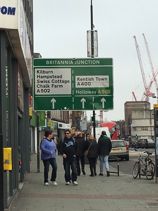
The bus deposited me on Camden High Street, a little north of Mornington Crescent. This isn't my favourite part of the world for a host of reasons, but mostly because in its slightly battered drag of chain outlets and copycat markets, Camden feels like what happens after gentrification. When I was a youngster, Camden was aspirational. The stars of British indie-pop propped up its bars, the record stores and vintage clothing outlets were legendary, the market was a wonder of new and old things which seemed exotic and impossible to us. It had developed this reputation slowly and surely through the 1970s, as the railway retreated and left large areas of land and old buildings free for exploitation. The real estate felt shaky and ill-kept, but that didn't matter to a post-squatter generation who liked their urban landscape to be edging into decrepitude. By the late 1990s, Camden was a different place. The huge footfall around the market and the High Street made the area attractive for the larger chains - and even though some of them were careful to invest their usually identikit outlets with a little uncharacteristic local personality, they were pricing out the smaller traders. Aside from the official market, every bit of clear land was taken up with semi-permanent stalls selling mobile phone cases, Bob Marley decorated stash tins, the usual stuff which could be found on the fringes of any shopping area. Each Saturday saw an influx of tourists eager to walk the High Street in order to pick up some of the perceived kudos of being seen around here, and the streets were full of expectant young faces from the provinces who - despite being in Camden - wanted the reassuring taste of McDonalds or KFC. First of all my route took a wide loop around this zone to find what might be the beginning of the A503 - heading counterintuitively west along Delancey Street and turning east again when I reached the bridge over the lines leading out of Euston Station. I'd strayed along this way in search of the bridge over a deleted arm of the canal, and knew the area a little. At Britannia Junction, the complex meeting of ways at the heart of Camden, I paused for coffee. I'd started earlier than usual today and needed the sustenance if I was going to make the distance. Looking out on what may or may not already be the road I was going to walk, I noted a gradual change. As the locals had headed for work or dissipated back into their homes, the steady stream of passers by appeared to gradually be shifting towards tourism. It was time to leave Camden.
I was briefly disorientated on crossing the street - Britannia Junction was a complex and many-armed beast. But the route I was taking almost immediately passed a familiar location - the same Sainsbury's I'd ended up detouring to find on my canal walk. I'd taken such a long circuit to get there last time that I'd lost the sense of just how close to the Canal I was for much of my Camden tribulations. This time I passed by, beginning to fit the area into shape in my mind - at least I'd have an escape route should I find myself here in future. As I slowly slipped out of the gravity of Camden the route began to change. Passing under the railway bridge at Camden Road station, beside its rusting and disused twin, I found myself climbing steadily on a broad suburban route. The stores thinned out into local hardware shops, convenience stores and petrol stations. The morning had started out grey but was clearing, and I was suddenly aware that the novelty of wearing a coat - something I've always studiously avoided until this winter when I finally found a comfortable and sensible garment for walking - was wearing off. I was far too warm. Getting an earlier than usual start on the walk and knowing I had accommodation in London overnight meant I could take a slightly slower pace than usual. No bad thing - this was quite a long route on pavement, with none of the diversion into the wilds I'd encountered recently on these walks. Despite having the time to divert and investigate things off route, I decided that wherever possible I'd stay true to the mission and indeed I largely stuck to the route I'd hastily planned. Above me the road was clearly marked: A503 Holloway, striking out north and east. Looking south when gaps in the row of tidy houses and small businesses permitted there were glimpses of the distant city as the road rose gently. Crossing the railway from St. Pancras on its broad westward curve towards Kentish Town, I sensed the change. I'd left the orbit of Camden, broken free and entered the uncertain northern hinterland which I'd spent so much time exploring in recent months. This part of North London doesn't quite cohere for me - districts blur and shift, and aside from the definite points marked by road junctions, the estate agents are drawing the maps here. The road stretched long and straight, reaching a peak from where I could see ahead to a fork. Where the road divided around a former garage with a gloriously modernist swooping roof, I took the left-hand path heading along Seven Sisters Road. Here, the A503 is a long one-way system enveloping Holloway completely in its two arms. Blank red-brick walls defined the perimeter of the former Holloway Prison. Empty and slowly returning to nature, the entrance was beginning to show signs of decay. It's just a matter of time before the sizeable site is snapped up and renamed to disguise its heritage. The area has a pedigree for residential land-grabs too - beyond the prison was a pleasant run of public housing owned by the City of London Corporation, one of the ten estates situated outside the square mile which it runs. Clean and tidy, the homes appear apparently well cared for and popular. I was prepared to find this part of the walk dull and mildly threatening but nothing could have been further from the truth. It is fair to say that Holloway is somewhere in the middle of a gentrification journey. Significant parts of the fringes of the area seem to be doing well, housing locals and providing decent services, while others seem to be undergoing that last, sorry stage of deliberate decay while their owners wait on the market and the right kind of investment into the area. At Nag's Head - where Seven Sisters Road meets Holloway Road - the scene is more disputed. As I lingered waiting for the confusing temporary lights on the crossing of the A1, I surveyed the area - it could be the centre of any London suburb, maybe even any small town perhaps. But among the well-known names and high street staples were a good number of tiny, local traders soldiering on behind long outmoded shopfronts. Beyond the stores to the north of the street was the muscular back elevation of the Beaux Arts Building on Manor Gardens. The front is a swirl of detail in brick, a grand Edwardian entrance to newly refurbished apartments - but the rear is stark, white and impressive. A single red brick chimney rises among the wings, which from above describe a trident pointing directly at the heart of London.
At Finsbury Park Station, the two arms of the road swing back together where the dome of the North London Central Mosque gleams over the three bridges carrying the railway north from Kings Cross. This mosque is something of a symbol of the triumph of peaceful Islam over extremism, with the Muslim Council of Great Britain seizing and reopening the site after a raid in 2003 which finally ousted the remains of the regime of Abu Hamza al-Masri. This splinter sect had been operating a programme of radicalisation from the building, some straggling tentacles of which reach forward into present-day terrorist activity. Emerging from the bridges, the transport interchange is a confusion of activity, with buses lurching around the tight curves outside the station. An unbroken stream of people are leaving the station with some Arsenal shirts already in evidence in advance of their FA Cup tie later in the afternoon. The sun had climbed above the buildings and I was starting to feel much too hot, but the road was curiously mesmerising - taking an almost straight course from district to district, through changing scenes which are both unfamiliar but entirely expected in their nature. North London is slowly starting to fit together in my mind, and the passing junctions connect me back to earlier excursons: the end of Stroud Green Road links me back to walking the Northern Heights. Everything finds its place here. Soon after passing the station the road quietened, and for a while it was just me and a constant stream of buses edging along the green fringe of the park. I'd walked this stretch before - between the treelined slopes and the long range of stucco-fronted hotels and large Victorian villas. It was pleasant to be out of the urban area for a while and to reorient myself by way of local landmarks: the towers of the Castle Climbing Centre and the forest of cranes at Woodberry Down. At Manor Park, I crossed Green Lanes and entered Hackney, completing my navigation of all arms of this important crossroads where the ancient road to the north crossed the relatively new turnpike. The organic cafe on the corner was busy - a signifier of how this area is changing, and indeed how quickly. The buses which have been shadowing me peel away north towards Wood Green and my route, now a broad dual-carriageway arterial, slips between the tall municipal blocks of Woodberry Down. On my left, some of the original blocks remain with their curved red-brick balconies - but as residents leave for the last time their doors and windows are securely plated over, the buildings slowly giving way to their regeneration. There's no rush to move them out - all the activity is to the south where the range of residential towers extends further eastward along the banks of the New River and the pair of broad, glassy reservoirs every time I visit. The desirable waterfront properties are for sale, not for rent, and definitely outprice the locals who are being slowly decanted from the ageing low-rise brick blocks. I popped into the local store and improvised lunch on the banks of the reservoir watching young couples leading curious children along the river path while ducks and gulls pecked around for crumbs. It was good to sit and cool off near the water and interesting to see how this area had changed since my earlier visits. The older population who had pottered the previous sandy incarnation of this pathway wasn't in evidence at all now, and there was a surprisingly homogenous feel. While the new buildings are undeniably a better environment in many ways, they don't appear to be fostering the sense of community which originally drove the aspirations of this early attempt at changing conditions for working people on a massive scale. Aware I still had some way to go, I set off to regain my route as it began a turn to the north at a crossing of the broad loop of the New River. Looking back along the inviting but still rather muddy river path, I had a view across the serrated rooftops of the somewhat directly named Harringey Warehouse District which sits at a distinctly lower elevation than the bank carrying the waterway. The A503 provides a boundary to Stamford Hill here, climbing respectably away from the factories and warehouses to the east with pleasant avenues leading away into Hackney. The walking was pleasant - perhaps a little cooler here, thankfully - and I relaxed into the rhythm of the traffic which was less intense along this stretch. The calm ended abruptly at the junction with St. Ann's Road which sat directly under the Gospel Oak to Barking railway line, the overbridge hemming the traffic into a complex junction and bottlenecking pedestrians into crossings which took an age to activate. Under the bridge it feels gloomy, damp and a little unsettling - perhaps reflecting the next part of the route? Looking ahead the road stretched onward between dilapidated and tired low rise housing and ranks of surprisingly attractive but mainly abandoned brick warehouses. Seven Sisters Road ghosts the missing edge of an incomplete diamond of railways here, the broad green areas of wasteland at its centre tantalisingly crossed by unofficial paths - but they're for a day when the ground is drier perhaps. A further railway bridge completes the diamond, and I'm in Tottenham - the change is imperceptible at first, but as I approach the A10 at Seven Sisters, the switch is suddenly closed. The tide of people waiting to cross the High Road couldn't be more multiculturally representative if an over-eager HR Officer had lined it up for a photograph. The junction throbs with life, a fog of traffic fumes undercut by the smell of barbecued meat and strong aftershave. Cars stopped at the light shudder with low-end from their speakers. Once, a ring of seven elm trees graced Pages Green - the original Seven Sisters - now a small linear park leads away east between the superstore and the terraced streets. The High Road is a stream of buses stretching north towards White Hart Lane and the tower blocks of Edmonton Green in the middle distance. For a little stretch I need to walk this route which absorbs the A503 briefly, marking a boundary between its distinct sections: the venerable turnpike and the ancient road across the Lea Valley.
Tottenham High Cross is an ancient marker on the route of Roman Ermine Street, often confused for an Eleanor Cross but somewhat plainer despite some added ornamentation in the early 19th century. Here I turn aside and head down into the valley, taking the appropriately named Monument Way. After a brief detour into a retail park at Tottenham Hale which feels oddly makeshift and provisional, I cross the vertical obstacles which separate North and East London - the Eastern Counties Railway, Pymmes Brook, Lea Navigation and the River Lea pass under the road in rapid succession. The valley bottoms out into a broad plain which has been flooded to form the chain of vast reservoirs which shadow the river here. After the Ferry Boat Inn, marooned on a spit of land between the Lea and the Coppermill Stream, the road joins a narrow causeway between these manmade lakes, with the railway curving in alongside. The gates of High Maynard Reservoir are locked to all except licensed fishermen - a regiment of heavy padlocks securing the gates, while wading birds strut the banks like guardsmen. Along the causeway unfinished electrification gantries from the recent railway works become a row of ominous monuments. In the distance I can see the land rising away from the valley floor, and I realise just how far I've got to go to reach my self-imposed destination. I'm distracted by designs etched into the pavement showing the transition: from industry and water to entertainment and nightlife. The progress from borough to borough is marked carefully - Waltham Forest wants us to forget the lines of pylons marching behind us and the broad swathe of churning green water. Ahead is art, culture, food and wellbeing. This once downtrodden borough is getting a very public makeover, its various urban centres being remodelled to promote promenading and restrict the motor car. Walthamstow is changing. I've seen the 'Awesomestow' banners - that clumsy appropriation fails on so many disturbing levels. I've also seen the row of achingly retro stores on the corner of Blackhorse Lane - the 'home of people who make and create' and I've seen the rebranding attempts as I've skirted the district, but today I'll be facing it squarely as I make a transit across Waltham Forest towards the east. I don't object to this area - in fact I rather like it - but I don't need to have this unsubtle exercise explained to me. Let us all discover - or rediscover - the borough. Don't force it, Walthamstow.
This is now Forest Road, and as it makes eastern progress away from the Lea Valley the stores return to type: small newsagents sponsored by Lebara and occasional hair salons. The pedestrian schemes are still incomplete out here, and the traffic remains dominant. Long ranks of tidy suburban avenues lead north and south and the road is fairly unremarkable aside from a fine modern Fire Station building. Rather suddenly, the carriageway kinks to the south to skirt the grounds of Lloyd Park House - now the William Morris Gallery. This sizeable but modest building sits at the corner of a broad green space beyond a walled garden, which is apparently well-used on decent afternoons like this. Formerly Water House this was the Morris family home from 1848 to 1856, while the adjoining Lloyd Park includes a moat which long predates the Georgian building. The space in front of the gallery offers a moment to rest and reconsider the walk - not least how I'll escape from the end of the road when I reach Waterworks Corner. I hadn't really planned for this - the road had seemed impossibly long, and the chance to walk without worrying too much about time had lulled me into not considering how I'd mark the completion of the walk. There was a way to go yet though, and as the road climbed towards The Bell and a house-sized mural of Morris glared across at me, I had a view of the distant green horizon where I was heading. My route skirted north of the central area of Walthamstow which clusters around busy Hoe Street, and remained resolutely suburban until I crested the rise and looked down on the pale verdigris of the clock tower topping Walthamstow Town Hall. As I approached, the full extent of this impressive civic complex unveiled itself: first a broad, low magistrates court building now closed and sold to the Borough Council as part of the Ministry of Justice estates rationalisation. This patently 1970s creation of the GLC Special Works Department can't truly be considered a brutalist structure, as it relies on Portland Stone to offer its simple but muscular face to the world. Beside it sits the more classical but no less imposing Town Hall by Philip Dalton Hepworth - a broad, mausoleum-like sweep of stone completed against all the odds in 1941. Its geometry aligned with a central fountain and a processional route to the doors, and I found myself precariously perched between the gates while trying to snap a picture. A citizenship ceremony was being completed as I approached, with impeccably dressed celebrants leaving the campus to the disgust of a couple of locals who leaned on railings, spitting and moaning about them "not being really British". As they'd inadvertently roped me into their conversation I pointed out that that was now exactly what they were. More spitting, more moaning about this 'fuckin' lefty'. Finally, the broad colonnade of the Assembly Hall completed the site and Forest Road began to climb again, passing the extensive Waltham Forest College buildings. This area is rigorously zoned, these public buildings dominating the east-west road as it cuts across the ridge between the Lea and the Roding. Nearby, a grandmother passed me, stooping to encourage a young girl and reassuring her in a surprisingly breaking voice that they'll do something "when mummy gets out". Initially I'm confused by the significance - but I soon spot Thorpe Coombe Hospital, a Georgian house turned into a Health Trust building with a residential psychiatric unit on site. I find myself sharing the young girl's pain and confusion, the sense of separation and the power of places to divide and distance. I'm surprised how this part of Walthamstow has passed me by before - the odd gravity of this administrative complex which powers the district like a civic engine room, dealing with its difficulties and tidying away the awkward and ill-fitting. I felt strangely ill at ease as the road turned uphill again, the horizon lost behind the ridge and the rising streets of Walthamstow behind me, if I'd dared to look back.
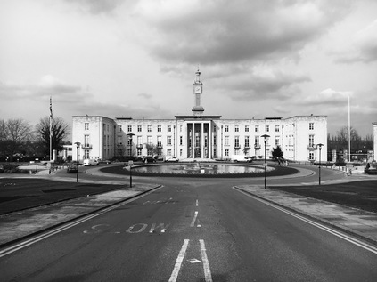
As I climbed, somewhat unexpectedly the deck of a footbridge appeared above the road - and as I slogged further up the rising path, the steep grassy banks supporting it emerged and I realised with some surprise that I was almost at my goal. The flat grassy deck above the sunken reservoirs opened out, and I could see the spot where I scrambled thankfully down from the forest path on my last walk here. Ahead of me the A503 ended at an unusual urban cattle grid near a junction with Woodford New Road, just shy of Waterworks Corner roundabout. I had mixed feelings as I approached the end of my walk - firstly, that I should perhaps press on further east, following the North Circular? The transition I'd made from the fading glamour of distant Camden to the leafy suburban spaces of Woodford felt jarringly odd and unresolved. As I circuited the roundabout to find a path across to the northern side of the shuddering and screaming A406, I noted the forest paths were still awash with thick mud and deep ruts. The subways under the roundabout were little more than continuations of the forest trail with strict instructions for horseriders to dismount. Beneath me, huge eastern European juggernauts paused in the lay-bys, the soles of their drivers' feet propped at the windows as they sleep until they're permitted to drive on. The traffic noise reverberated through the tunnels as I negotiated a route out onto Grove Road which edged along the deep concrete gouge which channels the road. The sun was beating down now, and there was a remarkably long view into the eastern distance. As the land fell away into the Roding Valley I had a clear vista of rooftops and distant woodland, and rather shockingly protruding from within the woods I saw the tower of Claybury Hospital winking into the spring sunshine. For a while I sat in the strange little makeshift seating area on the edge of Woodford where the North Circular cannons underneath the urban centre. A steady procession of happy young faces trotted into town, buses shuttled back and forth. It felt strangely peaceful - like the road echoing below my seat wasn't really there. I shuffled creakily into South Woodford to find a bus stop, conisdering that it could be any town centre in the home counties. Over my shoulder the tower signalled from my previous walks, shimmering over the ranks of heavily mortgaged Essex real estate. I was back in comfortable territory on the edge of things, but not everyone here was comfortable or secure. I thought of the girl and her grandma shuffling west from the civic centre of Walthamstow and of the sorrowful history of Claybury and its sister asylums, and I felt very grateful I was heading back to my own tiny family.
A gallery of pictures from the walk can be found here.
Lost::MikeGTN
I've had a home on the web for more years than I care to remember, and a few kind souls persuade me it's worth persisting with keeping it updated. This current incarnation of the site is centred around the blog posts which began back in 1999 as 'the daylog' and continued through my travels and tribulations during the following years.
I don't get out and about nearly as much these days, but I do try to record significant events and trips for posterity. You may also have arrived here by following the trail to my former music blog Songs Heard On Fast Trains. That content is preserved here too.
