I realised as I sat on the near-empty Northern Line train, shuddering noisily into the light somewhere in Finchley, that my previous visit to this part of the London had been a very long time ago. In fact my last traversal of this part of the Underground network was before I kept records of such things. In the mid-1990s I'd embarked on a project to cover as much of the Tube as I could - despite a crippling phobia regarding escalators - but this involved nothing more fastidious than marking the lines on a map. Now I was clanking into the quiet terminus at High Barnet once again, with a new project - and this time I was taking careful notes. I recalled at least that I made a dash on foot between High Barnet and New Barnet stations at some point around twenty years ago. It's perhaps no surprise that I don't remember the route in detail, but my abiding impression is of surprise at how ordinary and suburban things felt. How oddly short on spectacle things seemed, surfacing at last after delving into the earth just a few miles south in the middle of all things. I also remember that what appeared a thumbnail-width smudge of yellow between the stations on the map was in fact a fairly long walk. Outside those specially amplified 'Central Area' pages of the A-Z, scale is elusive and strange, London is elastic. I hadn't learned the over-used term 'range anxiety' then, but I felt it acutely. I need not have worried - I was imposing my ever-invasive provincial fear of 'missing the train' on a route with a far, far better service than a young man from the sticks could even imagine. My other conclusion however stands two decades later: there are just too many Barnets. High Barnet, which is - it seems interchangeably - Chipping Barnet sits high on a ridge of land in the midst of this confusion, with Barnet Gate out to the west in the Dollis Valley and East Barnet - perhaps predictably - to the east in the valley of Pymmes Brook. Between the two is the decidedly misnamed New Barnet. South of all of this, nearer to Southgate in fact, is the outpost of Friern Barnet. I can only wonder what horrors this area must have wrought on the early life of Keith Joseph who was Minister of State for Housing and Local Government at the time of the creation of new London boroughs. Despite a local committee coming up with modern, fresh and non-partisan names such as "Northgate" or "Northern Heights", Joseph - requiring as noted by The Times "the wisdom of Solomon" in this matter - opted simply to name the new entity Barnet. Keith Joseph's ideas appear to have staying power - he of course went on to play a part in the creation of Thatcherism which still exerts its peculiar influence on Britain today - and Barnet is still a rather unconvincing meta-place - an artificially constructed borough which contains many communities with competing and contesting identities. Like Barnet, Joseph was never much in the limelight, content to be the supporting act. He is, I suspect, one of the local spirits of place here.
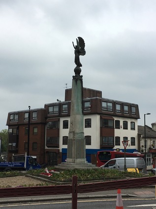
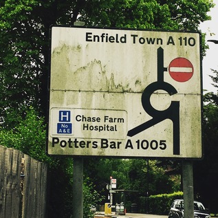
Early indications for today's excursion aren't promising - I head out of High Barnet station and immediately realise that I should have crossed the busy A1000 sooner. The footpath runs out and I'm forced to make an ungainly crossing by a glaring bus driver who seems unable to pass by and insists on allowing me to go ahead of him. I'm wearing brand new walking boots too, and while they're undeniably comfortable, I'm conscious that I'm about to walk a good distance in them for the first time. Not used to a good thickness of sole beneath me, I frequently misstep at first, bringing my left foot to a scrunching halt while the rest of me continues unabated. It's not pretty, I'm sure, for the bus full of people who just want to escape Barnet but are treated to this spectacle. As I arrive safely on the western side of the road I'm gladdened to see the view across the Dollis Valley spreading out to the west. Lush and green, punctured by red brick houses and clusters of apartments, it is also tantalisingly unwalked. This is the edge of the quadrants - London's great divide - where the rivers turn east or west away from this high ridge. A misty haze beyond Barnet indicates the edge of London - and helps to contextualise just how high up I am here. Today will literally have its ups and downs as I head east from ridge to ridge. If I'm serious about this project, then I'll need to get used to clambering up and down the valleys of the various brooks and rivers I've walked before, and potentially many I haven't. A little south of the station, as the Northern Line passes overhead on route back to the City, the object of my excursion shows up for the first time. It does so on an amateurish road sign which uses the wrong font and a frankly elephantine arrow to guide us east along the A110 for East Barnet, Cockfosters and Enfield Town. This is where my walk starts in earnest. After ceremonially popping into the local Tesco Metro which faces up across the street from the impressive Everyman Cinema at the junction, I stride off into the northern suburbs. The A110 has cropped up in several of my previous walks, and I'm curious to see how familiar it feels as it links them together. It's clear that I definitely have no abiding memory of this stretch - but it's equally plain why this feels hazy. The rank of pleasant brick villas which fringe the street is broken at intervals by the flapping white dust-sheeting which hides redevelopment. Each masked building is slowly becoming a small but luxurious block of apartments on the footprint of a former large family home. Where these new builds are complete, the pattern is clear - curving balconies fringed in bright metal bow out towards the road, and impressively secure gated entries protect the ground floor from interlopers. The street is busy with through traffic while postmen and delivery drivers weave between them making regular stops to pitch Amazon parcels into capacious letterboxes. A gentle descent begins, and I reach New Barnet which is heralded by Newbury Trent's angel of peace sculpture topping the war memorial. The junction surrounding the angel is a churn of roadworks and traffic, and I'm forced to almost completely circumnavigate the statue to get across the street. The angel, a weird mixture of classical and modern design, walks serenely to the west, her eyes forward and hands raised, holding a feather aloft. It feels strangely like she's begging to be lifted out of the chaos and fume around her. The rest of New Barnet is less modern and certainly doesn't feel new at all. In fact, considering the surrounding suburban affluence I'm a little shocked at the down-at-heel feel of some of the crumbling Victorian shop fronts which I pass after the low bridge under the line to Kings Cross. My route turns south here and begins to descend more markedly to the east. A little further on, the A110 turns left at an entirely unmarked junction to avoid East Barnet Village. I've successfully avoided East Barnet before, skirting its edge when I walked Pymmes Brook - and I soon realise with some surprise that I'm approaching the point the brook passes under the appropriately named Brookhill Road. This feeling of recognition in an otherwise strange place is a curious one - and as I wander by the closed computer shop and car hire facility which I'd vainly hoped held at least a chance of refreshments on my last walk, I realised that the delights of East Barnet Village such as they were, had been lurking just a street away. I also recalled that while last time I'd been relieved to turn south along the brook, this time I'd have to climb Cat Hill which was just as steep as I'd remembered. Again, at the junction there was little recognition of my route - except for the rather unusual inclusion of 'A110' beside the street names. I began the climb and surprised myself by not feeling exhausted within seconds. Perhaps this walking had some longer term benefits after all?
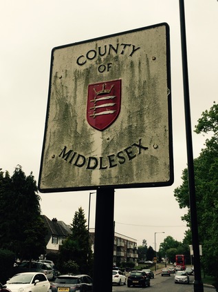
At the top of Cat Hill I stood on another ridge - this time dividing the valleys of Pymmes Brook and Salmons Brook, two minor but significant watercourse here in the north. Still a little surprised by my improved stamina, I pressed on over the ridge and onto the tongue of land which separates the valleys. Across the street, a residential cul-de-sac intriguingly called Daneland promised misty views over the falling ground south towards the distant city. With the low cloud and overcast skies it wasn't possible to see far so I pressed on, pleased to be on relatively level ground. A little way to the east, the A110 faced the most important junction I'd crossed so far, meeting the A111 at a sizeable roundabout. From here, routes reached north to the M25 and south-east towards the North Circular, with the journey onwards into Oakwood perhaps the least important of the four ways. As I navigated my way around the circle of traffic, I remembered that this junction had until relatively recently been decked out in a full set of old style pre-Worboys direction signage. My early obsession with British roadsigns had begun when these relics of a prior age of motoring were reasonably common - but sadly, now the rather ordinary modern signs simply indicated my route towards Enfield, five miles hence. There was one signage related surprise to be had though - a little before the roundabout on a pole almost obscured by trees I spotted a sign indicating I would have been passing into the County of Middlesex. The very same boundary changes which had created Barnet had done away with this ancient county which has its roots in the Saxon kingdoms which dominated the south of the British Isles. While other counties had ceded territory to the beast that was Greater London, Middlesex was swallowed entirely by it. The rise and fall I'd walked so far today was once a narrow tongue of Hertfordshire which curved south and east into what had been a proud county in its own right. As I passed into Southgate I had crossed the ancient boundary which was now barely celebrated as the border of Barnet and Enfield. The surest indication was the changed insignia on the green wheelie-bins which lurked at the end of each drive. Middlesex has all but disappeared in the mind of anyone younger than my generation - we at least had the last rites: sending our letters and pictures to children's TV studios with Middlesex postal addresses long after the county had passed into history. That said, this now erased unit of democracy has had its champions, and as I trudged by the stark, modern brick slab of the Church of Christ the King on the perhaps optimistically named Peace Close, I recalled the lines:
Dear Middlesex, dear vanished country friend, Your neighbour, London, killed you in the end.The flame of Middlesex also still burns of course in the painstaking and sometimes torturous research of Nick Papadimitriou. Nick would contend that somewhere along his endless scouring of hedges and retail parks, he has become Middlesex. I was aware of walking in his footsteps often in my northern excursions, and spotting this fragment of tangible history brought his eccentric progress around the northern heights to mind. Perhaps he was out here right now, beating the boundaries? I pressed on into Middlesex, realising I'd be passing entirely through the ghostly tail of the erased county if I managed to complete today's route.Sir John Betjeman, Marble Arch to Edgware, 1968
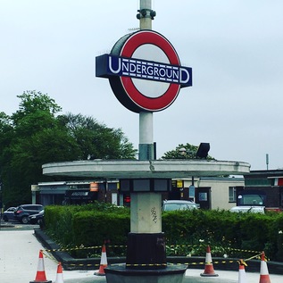
Soon after entering Middlesex I passed the imposing Oakwood Station. The huge brick and glass box designed by Charles Holden seems almost too grand for this once remote outpost on the 1933 extension of the Piccadilly Line. Serving as the line's terminus prior to Cockfosters opening some months later, the line swings north and west through a broad fan of sidings here, which extend almost all the way to the new terminus. For a while though, this fine modern station was an early battleground between the future London Boroughs which abut each other here. It's a convoluted tale - the station being initially named Enfield West despite suggestions including the frankly inflammatory East Barnet. A consolatory (Oakwood) was added to the name later, and so it stood for the next decade or so. Like many of the inter-war extensions to the Underground network the speculatively built suburbs which now surround the station followed the rails slowly, and initially Oakwood stood in isolation on unpeopled land between the two ancient municipal seats of Barnet and Enfield. The spat was finally settled in 1946 in favour of simply 'Oakwood' via the intervention of Southgate Council, who noted their claim on this area. Southgate Council was to pass into history in 1965 along with the other players in the convoluted tale of the station's name, but Oakwood remains simply that - with a tall Underground roundel pierced by a slender spike and set imposingly next to the road. Beyond Oakwood, north of the road, the health club and golf facilities at Trent Park limit the further growth of the suburbs, and after passing the station there is a surprising and uninterrupted view north into the hills of southern Hertfordshire. With the haze beginning to lift the broad sweep of southern England was oddly breathtaking and a remarkable contrast to the suburbs I'd been plodding through. Tempted by the various cafés which lined up alongside the station and its parade of shops, I managed to continue east. With the A110 forming the northern boundary to the suburbs here, I was keen to cross the street and walk on the rural side of the road. I was rewarded with unexpected flashes of green hills and distant woods peeking between the trees and scattered farm buildings. I noted though that there were frequent warnings that this was Private Land which seemed oddly unnecessary. My curiosity was answered a little further ahead by a neat banner hung on a gate to promote Enfield Road Watch. It seems this green fringe is under threat from development. It's easy to see why the locals would want to protect this zone - and equally hard to imagine what more attractive place a speculative developer could find for their new urban extensions than this Underground connected semi-rural haven. Perhaps the modern builders will finish the job begun between the wars - but I hope the locals prevail, just for a little longer at least.
The straight road ahead of me began to delve down into another valley and I could see the higher ground of Enfield Town rising away in the distance, church towers and impressive houses flanking my route ahead. The ridge I'd been walking since East Barnet tapered down into the the catchment of Salmons Brook, bottoming out at World's End where I'd begun my walk along the waterway last winter. I knew this meant a long slow climb up Slades Hill on the other bank of the stream, which I wasn't looking forward to - so I rested a while near the brook, watching traffic zipping down the rollercoaster created by the valley bottom. Eventually I set off again, taking the steady climb again surprisingly in my stride, slowly progressing through the ranks of imposing homes on the outskirts of town. Enfield is a curious place with its own onion-skin layers of development emanating from a busy centre. Once at the top of Slades Hill, the Ridgeway swings north to head out to Potters Bar, and my route gently slopes into town via a long terrace of shops caught in mid gentrification - the ubiquitous Ladbrookes standing next to quaint little organic eateries and just across the street from a Waitrose. There's a pleasant buzz to the slowly emerging town as I cross the idyllic loop of the New River with ducklings skittering around behind their mother, and pass under the railway near Enfield Chase station. I take a moment to pause for coffee in the busy high street near a somewhat upscale street market selling artisanal foodstuffs, probably a world away from the business conducted in the square for centuries before. I notice too that the installation of Britain's first cashpoint is market with a small blue plaque too - and I can imagine based on trade today that it was well used. My last visit to Enfield was early in the morning when the meeting of ways centred on the war memorial was almost entirely deserted - but today the pavement is wedged with shoppers and I'm glad to finally strike out east again, beside the restored and pleasantly reedy old course of the New River towards Southbury. The town gives way to straggling suburbia as the New River turns north to regain its main route, this last stretch not yet restored and little more than a reeking green ditch between ranks of decaying metal siding. There is a haze of traffic in the middle distance as the road approaches the crossing of the A10 - the Great Cambridge Road. A huge leisure complex looms on the northern flank of the carriageway, the building silvery and impenetrable - unless one pays the requisite fees of course - but offering all the refreshment and entertainment you'd need within. The self-contained pleasure centre is served by its own footbridge too, meaning that access can be gained without taking your chances on the busy road crossing - they want to be certain your wallet arrives in one piece of coure. Those of us wanting to pass over the A10 however have to navigate a complex of traffic signals which interrupt six lanes of growling, shuddering vehicles rudely brought to a stand at a red light. It's an uncomfortable intrusion into my walk, which while it has passed along busy streets, hasn't encountered a main arterial like this at all so far. I've been aware of but shielded from London on this cross-route it seems, and here I'm crossing one of its primary gateways - bored motorists gunning their engines waiting either to enter or escape the gravity of the city. I'm an irritation. Why would you walk out here? I'm glad to be over the boundary which the road creates and entering the familiar edgeland scenery of Southbury - vast supermarkets, retail hangars and distant tower blocks. I can feel the magnetic pull of the Lea Valley beyond. This is more my usual kind of place, it seems.
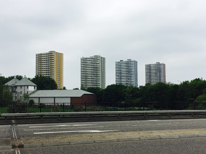
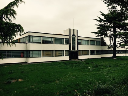
The change in zones is tangible - and almost jarring. At the hump in the road where it heaves over the line to Liverpool Street is the tiny, Victorian red-brick Southbury station, marooned atop the bridge and crowded in by two solid and miserable new-build cubes. The road falls gently away ahead of me as the solid brick terraces of Ponders End close in. Looking to the horizon, a band of green indicates Epping Forest climbing away from me to the east. I try not to feel too elated to see my goal - the land between here and the forest is flat and deceptive, and I'm really only just over half way along my planned route. This long, flat passage into the Lea Valley is oddly tiring. The roadside scenery has been a constant band of retail unit grey for some way, and the dusty carriageway is plagued by too much traffic going far too fast, making the dodge across the valley here to avoid the sluggish progress around the North Circular. Opposite the station is a curious survival - the art deco Ripaults cable factory - a smooth, aerodynamic gem of the type of building which seems to crop up more readily along the western arterials out of the city than here in the east. Now in the care of builders' merchant Travis Perkins, the paintwork is pristine and the building remarkably well-kept. Almost too clean in these dirty, dusty surroundings. The listing of the building clearly helps. Looking around I'm reoriented by the appearance of four dominant tower blocks. I've seen these huge buildings before from the other side of the valley - built to an entirely different scale to the surrounding low-rise light industrial landscape. Curlew, Merlin, Cormorant, Kestrel - the four guardians of Ponders End line up attractively for a gloomy cross river shot, but close up they are more human in appearance if no less impressively massive. Practical, unadorned and straight-sided, their only concession to decor are the coloured panels which run down each block, distinguishing it from its siblings. The alignment from close quarters is tighter and the blocks feel huddled for safety here, rather than the overbearing aspect they posses from the east bank of the Lea. I snap shots from a few angles, enjoying the way the scene changes as I gain ground on the blocks, then slip by them. Suddenly, I'm at a roundabout near Wright's Flour Mill, the old industrial buildings oddly out of scale with their modern surroundings. The signs here encourage walkers and cyclists to head down to the footpath on the Lea Navigation, but I'm determined to stick to my plan - however uninviting the bridge over the river has been made. After negotiating a road sign planted inconveniently in mid-path, I find myself on a narrow pedestrian refuge inside the crash barrier. Ahead of me, the green of the valley sprawls north and south, the ubiquitous pylons ranging left and right. Below, the first branch of the navigation is calm as it winds around a broad meadow in front of a Harvester restaurant named for it. I recall this spot from a previous walk along the river - where the way splits and a substantial loop of water disappears behind the riverside inn. Further to the east I can look back and see the view from a new angle, marvelling at the complexity of the watercourses in the valley. A little further ahead the expansive valley view is gone, and the road enters a deep green chasm between the huge reservoirs. Sheep graze on the banks investing only cursory interest in the solitary walker on this causeway, and seeming to be entirely untroubled by passing vehicles. I almost a little oppressed by the presence of the vast bodies of water above me on both sides. I also feel strangely and conspicuously alone, despite the regular pulse of traffic on the road. The valley never ceases to find new ways to feel strange and unnerving - perhaps one of the reasons I'm drawn back here again and again.
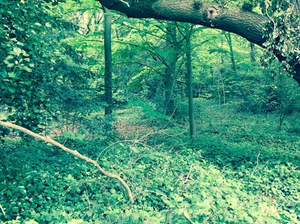
As the reservoir banks taper down to ground level at a knot of complex water-related buildings and pipeworks, I cross the final channel in the tangled web which the Lea weaves along the valley. In doing so I leave the traditional County of Middlesex behind and enter Essex. Except of course I don't - in the post-1965 scheme of things this is Waltham Forest. More accurately it is the foot of Kings Head Hill, a long and steep drag up to the ridge on which Chingford sits, between the valleys of the Lea and the Ching. This is well-marked territory for me, but I've never arrived from this direction and it requires a little orientation before I place myself in relation to previous walks. As I trudge up the hill, spotting the green tump of Pole Hill rising away from me to the north and recalling the wonderful views which it offers, I consider how Chingford has become an unlikely locus for me. It's the kind of place which figures in bad panel-show jokes. If some mildly left-of-centre comedian wants to complain about poor public transport he (and it is, almost unerringly he) will mentioned 'the 8:15 from Chingford'. Whether this train exists, or whether it is peopled by the kind of middle-class conformists he's lampooning is immaterial - by invoking the name Chingford he's conjured an image in even the most provincial of minds. The place is of course far more complex than I ever expected - and while it has plenty of the anonymously similar middle-class housing I'd assumed would be around, it has a tangle of new-Essex bling, a remarkably long history as a forest community and is a surprisingly strong strategic position for exploring the area. At the top of the hill the ways divide around the Church of Saints Peter and Paul and I take the opportunity to rest under some non-standard County of Essex installed fingerpost signs which send me towards Epping and Waltham Cross. The old road into town is a car-free path here, which is busy with all kinds of people, persuaded out by the sun which is now in evidence after a gloomily hazy morning. The sign to Woodford helps me to realise I have a way to go, and I'm surprised to find myself unhappy I can't wander into Chingford and relax for a while before plunging into the forest. Instead I press on along the A110, now a fairly unimportant cross-route which isn't going anywhere too useful just now. Traffic for the M25 has long headed north, and the crossroads at the foot of the hill took the last of the city-bound traffic. You'd only be on this road if you needed to be. The road parts again at the Four Wents - a fine old Essex term for a route or way - and Friday Hill, the southerly route, seems to take the strain leaving the A110 almost deserted except for the occasional speeding BMW. South of here is the remarkably named Pimp Hall Park which I mentally note I must visit at some point. Chingford doesn't end as such - it tapers into leafy suburb, then there is rather suddenly more leaf than suburb. I'm surrounded by a familiar green light and the damp, woodland smell rises from the drying ground. I'm back in Epping Forest. Tantalising paths spin off right and left, delving between trees into gloomy thickets of ancient and largely unmapped woodland. The draw of the forest is remarkably strong. As the road begins a curve to the south, I cross the River Ching and find the pathway I'd used on my winter trek. Whitehall Plain opens to the north, free of frost and mud in the pleasant sunshine - and I can't resist following the path a little way alongside the river. When I'd walked here in January I'd had to stick to the open field as the river path was impassibly sodden and treacherously iced over. Now I could scuff along the forest floor, noting that the unfamiliarly thick, new soles of my boots made me stumble over roots and stones. I was used to my old, worn down pair and was learning to walk in these afresh. It seemed fitting to offer them a first taste of walking in the forest today.
Eventually I returned to the A110 to finish the walk. The last stretch was quiet and leafy, skirting the pleasant grounds of the surprisingly large Bancroft's School and coming to rest at an inconspicuous junction with the A104 heading south into Woodford and Walthamstow. I crossed the busier, wider road and looked back along the A110. There was little to distinguish it as an important route for the many, many Londoners who used it, or for the relief of the more important cross-routes and orbitals which already bear an impossible load of traffic. Does anyone ever need to drive from its convoluted contortions in the west to this rather austere eastern terminus? I suspect not - it is a road used in familiar, everyday parts by people who live along the surprisingly diverse course. It's a rat-run across the valley, a useful dodge to avoid the North Circular, an easy way to get out towards the M25. Today, for me at least, it has plotted a course across the northern edges of London, across ancient Counties, meddling municipalities, and across the undulating valleys rising from the Thames. There are many more of these odd routes to walk - and it appears I may have accepted the challenge...
A gallery of images from the walk is here.
Lost::MikeGTN
I've had a home on the web for more years than I care to remember, and a few kind souls persuade me it's worth persisting with keeping it updated. This current incarnation of the site is centred around the blog posts which began back in 1999 as 'the daylog' and continued through my travels and tribulations during the following years.
I don't get out and about nearly as much these days, but I do try to record significant events and trips for posterity. You may also have arrived here by following the trail to my former music blog Songs Heard On Fast Trains. That content is preserved here too.
