London's Other Orbitals: The North Circular - Part 2
Posted in London on Saturday 15th July 2017 at 11:07pm
The next bus stop is closed...
I just made it out of the rear doors of the bus, which had patiently sat on the roadside near the Big Yellow Storage building for whole minutes before it decided to make the automatic announcement. Through a surprisingly less convoluted route than I'd expected, I found myself just feet from the bridge carrying East Finchley's High Road over the A406. In fact, I was just several more feet from where I'd exhaustedly plopped into the seat of a southbound bus a few short weeks ago, a sweaty and dirty character - the cause of much suspicion among my fellow travellers. Getting off a stop early allowed me to regard the North Circular from above as I crossed the street and headed for the footpath down to the road. It was a strangely gloomy and ominous morning, with unexpected clouds tumbling overhead as I gazed east along the road. I realised that I'd talked a lot about the wisdom or folly of undertaking this journey when I wrote my account of the last walk, and that in the process I'd clearly managed to convince myself that this was an enterprise worth completing. It wasn't without some trepidation that I followed the curve of the slip-road down towards the woodland fringing the carriageway, noticing a hi-vis wearing photographer trying to get a really good shot of a bowl of foraged blackberries he'd balanced on a fallen limb. When I'd surfaced from the road last time, I'd felt the effects for several days afterwards - a heaviness of limb and a dry throat - which made me wonder if these really were safe for eating. He didn't seem to mind, pluckily popping in a berry as he posed the bowl for best effect, wincing at the tartness of the fruit. Rejoining the road at Glebelands Wood wasn't a bad thing - it made for a relatively pleasant initial stretch of walking, despite being close to the traffic. A fragment of the ancient Finchley Common, the narrow band of woodland bordered by the North Circular and bookended by a large Tesco Extra is one of the few surviving areas of ancient woodland in Barnet. At the eastern end, a narrow tract of green space running along the Bounds Green Brook joins it to Coppett's Wood, another area worthy of an exploration at some point. Today though, the woodland kept me cool while a tall fence separated me from the brook, at least as far as the superstore. I popped inside to grab provisions for the walk ahead - while I'd never be far from civilisation, the road was sometimes a difficult place to find sustenance it seemed.
On leaving the store, it was raining - just a little, barely enough to bother the shoppers piloting their trolleys towards the doors in fact, but nonetheless I'd believed the forecast and didn't have a coat. Leaving the retail park by a pedestrian entrance I found the Bounds Green Brook just across busy Colney Hatch Lane. The name reminded me of another of the great ring of asylums which circled London - this one the scene of a terrible fire in 1903 which altered to an extent the public perception of these hitherto mysterious hospitals. The asylum - later Friern Hospital - lay a little to the north, and when opened in 1851 formed the second Middlesex County Asylum. The elaborate buildings struggled on as a hospital until 1993 when the final patients were relocated in the community. During its surprisingly long tenure in similar use, Colney Hatch became notorious - for its sometimes harsh conditions, and as a receptacle for some of the most infamous criminals deemed insane - once housing Aaron Kosminski, credibly suspected of involvement in the Whitechapel Murders. The buildings are now, predictably in luxury residential use as the suitably anonymous Princess Park Manor. Ironically the grand gateway which stood open while the hospital was in use, is now very securely closed. To keep people in or out is perhaps an interesting question?
When day dawned, while some of the firemen pumping water from the brook below continued to play on the red hot débris, others began the terrible task of searching the ruins. Then it was discovered that the fire had claimed many victims...The Times, 28th January 1903
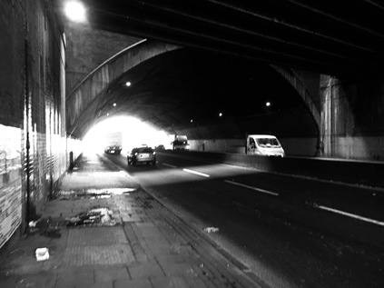
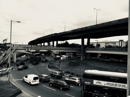
The brook was sluggish and algae-filled - and it reeked. A slow-running stream in the summer is going to become a little ripe, but this was the stench of sewage. Another watercourse which appears to be plagued by misconnected domestic outlets. The brook soon disappeared behind the fence once again, and after a few moments of walking along the road, I realised I was climbing along a slip-road towards yet another retail park. This one presented a bit of a barrier, but a path offering a way back down to the North Circular appeared and I was soon passing underneath the tall totems advertising carpets, pets and fast food. The road was running as slowly as the brook - with traffic merging into the centre lane to avoid some obstruction up ahead. As I trudged a dusty section beside car dealerships and vacant lots which supported a burgeoning blackberry crop, I spotted the embankment of the railway to Kings Cross up ahead. I'd rather dreaded this bit in fact. Here, the A406 passes under a long, low bridge. So long in fact, that it almost forms a tunnel under the swathe of lines and the site of former sidings. Beyond the tunnel, a large gasholder loomed - reminding me that safety wasn't far ahead. Nonetheless, I had to endure a few minutes of being hemmed up against the sweating, Victorian brick arch while six lanes of traffic howled and shuddered feet away from me. As it happened, the broken down car which had been causing issues a few yards back helped me out here - having finally sputtered to a halt just shy of the tunnel mouth. Thus I had a good, wide lane entirely free of traffic separating me from the main flow of vehicles regaining speed after slowing to negotiate the broken down car. The occupants of the stricken car looked strangely unconcerned, poking at their 'phone screens while they awaited rescue. I picked up the pace, my steps echoing reassuringly into the distance. The light at the end of the tunnel seemed brighter, and free of the rain which had threatened its presence in the form of a unconvincing drizzle so far. Once inside, the noise was remarkable - a constant swish of air preceding passing vehicles peppered by occasional horns and the thrum of motorcycles. I wondered if I should even be down here - but there was after all a footpath. I wasn't sorry to escape, bursting into the comparatively fresh air of Bounds Green. The brook ran in the open again beside me, and while it was still a little noisome, it was bearable to stray towards it where the undergrowth allowed for pictures. The road had collapsed into a single, broad carriageway with only a set of advisory markings dividing the east- and westbound carriageways, while the Piccadilly Line surfaced to pass above just a little way ahead. This area was once notorious for planning blight - the various proposals for improving the road almost all insisting on the demolition of houses on the southern side of the road. Now though, the attractive run of mid-century semi-detached homes seem to be tidy and all in use. But life here must be strange - the North Circular outside their front doors, and heading for a notorious pinch-point on its semi-circuit.
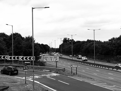
To someone who isn't as enthusiastic about road junctions as I - which is probably most people - the meeting of Telford Road and Bowes Road at a crossroads in suburban Arnos Grove is likely to be inconsequential. However, for the motorist making a steady progress around the edge of the city, this is likely to be where things get a little slower and a lot more confusing. Here the North Circular makes an abrupt ninety-degree turn to the right, crossing traffic from a couple of less major but still busy local roads. The mess of traffic lights, the confusion of signs, and the absolutely counter-intuitive oddness of this manoeuvre is explained by the very earliest plans for this route. Using a mix of purpose built new road and the existing pattern of streets, the plan was to form a designated route rather than a distinct, newly built path through the city. At points like this junction, the layout remains much as originally planned. There has been some work to divide flows of traffic, some clever work with traffic signals and priorities - but essentially, an urban motorway screeches into a Victorian crossroads here. I navigated the crossings carefully, picking my way from the north-western to south-eastern corner of the junction by instinct - there was little in the way of direction for pedestrians. The steady drizzle of rain had become a more sustained fall and I was aware I was getting rather wet. Bowes Road picked up the baton for the North Circular in somewhat more sensible style - becoming a broad urban dual-carriageway between a parade of local stores and the recognisable frontage of a long-disused cinema - The Enfield Ritz, now in the service of the local Jehova's Witnesses who to their credit appear to have done much to preserve the building. Beside me, a long development of new-build flats on what appeared to be the liquidated edge of a school playing field was being constructed. As I passed the show home, optimistic salesmen were setting out the signs for a day of being ignored by motorists. I noticed with some surprise that the upper decks of these small but otherwise decently built flats had balconies overlooking the A406. I wondered what odd, Ballardian mind had designed this building, knowing that on the best of British summer days, the view would be a distorted vista of the severe Board School buildings through a hydrocarbon-laced haze? I knew that this section of the walk would lead me to a number of areas which I'd recognise, and Powys Road soon interrupted my weighing up of how life here beside the road might be? I'd strayed a little along this street while searching for Pymmes Brook, finding a proud bridge parapet constructed for Southgate District Council in the midst of the fine suburban homes. I mentally assessed my position - once again the North Circular had appropriated the flat valley-bottom of the brook for its alignment. Up ahead, the Hertford Loop of the railway from Kings Cross passed overhead on a long, slewed bridge, the overhead wires sizzling quietly in the rain. Beyond the bridge a palisade fence marked the crossing of the New River under the road. I swerved through the narrow kissing gate and onto a muddy and litter-strewn path between the embankment of the railway and the river, emerging on the quiet grassy bank beside the water. There is something oddly tranquil about this waterway at any time, but having just escaped the tumult of traffic on the North Circular, it felt especially calming. Emerging from a utilitarian concrete culvert under the road via a litter-festooned debris trap, the river curved away to the northeast, crossing Pymmes Brook somewhere in the middle distance. I paused for a while, the rain was stopping and this seemed a fine place to wait it out for a moment. It was comforting to be connected to a part of London I knew better at last. While striking out into the unknown has its attractions, the sense of familiarity was welcome just now.
That feeling of being somewhere I knew fairly well persisted - the crossing of Green Lanes was one of the places I first remember needing to interact with the North Circular on my travels. Then it felt like an insurmountable barrier - an almost impassable point beyond which pedestrians weren't welcome. I thought back to those earlier walks as I picked my way across the tangle of crossings near Palmers Green Bus Garage, and set off again alongside what was now a busy four lane highway between more of the typical suburban dwellings which had lined the route since Chiswick. The road still curved elegantly along the valley of Pymmes Brook, crossing it via an inconspicuous metal bridge soon after the Green Lanes junction. The brook wound eastwards via Tile Kiln Lane - a quiet patch of nature reserve I'd walked before. This time I stuck to the road, most of my walk towards Great Cambridge Roundabout being along a service road separated from the traffic by a thick, thorny box hedge of the type beloved of Local Authorities everywhere. The spiny stems trapped the swirling litter and repelled sound, reducing the traffic noise to a dull rumble from the front rooms of the homes here. As I climbed up to the level of the tall red-brick arc of bookmakers, take-aways and letting agencies which ring the junction with the A10, I realised I'd need to head under road to get back on route. The subways here are confusing, poorly signed and a little unwelcoming - mostly because the cycle path fills most of the width of the passage, requiring pedestrians to hunch alongside the edges of the tunnels uncomfortably. The walls are clad in shades of brown and cream, betraying the vintage of the last reconstruction of this junction. In the midst of the roundabout, the North Circular passes beneath, a weird, echoing roar coming from the deep concrete channel in which the road reverberates. It was oddly compelling watching traffic surging along the road I'd been accompanying for so many miles, now businesslike, buried beneath the A10 - a sizeable and important road in itself, one of the impressive radial routes constructed in the 1920s - but it seems even these venerable byways must give way to the unstoppable North Circular. Beyond Great Cambridge junction, I'm on very familiar territory. Avoiding the trap of being lured onto Silver Street - the former route of the North Circular - I walk the narrow footpath beside the traffic once again. This is the least welcome I've felt as a pedestrian for some miles. The path feels inconsequential, littered with dirt and dust from the road, and hemmed in by a crash barrier. There is private green space beyond the fence, and within the tangle of allotments and gardens, Pymmes Brook still runs. I'd tried in vain to walk that way before and ended up here on the roadside. Up ahead, the layby was still the temporary home for a small community of Polish truckers who appeared to be engaged in a small cycle maintenance sideline too. I politely slalomed around their handiwork, passing under the sign which told me that I, along with any horse-drawn traffic, would be forbidden from walking along the road in a quarter of a mile. I wondered as I covered this short distance what was less common here - pedestrians or horses? I'd seen none of either since Great Cambridge Junction. The rather baleful buildings of the North Middlesex Hospital loomed over the road, and another unwelcoming subway passed under the road to reach it. Up ahead, the gantry signs flickered up a lane-closure as the road passed into tunnel under Edmonton. The traffic reacted by groaning to a sudden halt. Horns sounded back along the carriageway. I slipped gratefully into the relative calm of Pymmes Park. The road was ever present, but the tall railings, the algae carpeted pond and the unconcerned ducks nodding their way around the islands of reeds made for a less turbulent atmosphere. I picnicked absent-mindedly, wondering how far I should try to get today? Despite a sense of familiarity, the road seemed endless, all-encompassing and somewhat unfriendly here as I passed from North London into the East.
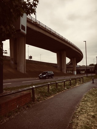
Reluctantly leaving my comfortable bench, I headed under the Overground near Silver Street station and crossed the chaos of Fore Street. The North Circular resurfaced from its brief subterranean section, and I was again alone on the pavement beside it. The busy tumble of businesses which straggled alongside since the crossroads soon petered out, and it was just me and the traffic once again. The skies widened in front of me as I approached the Lea Valley with only Scott House, a tall slab block to the south of the road, to interrupt the suddenly darkening skies. Another downpour was coming, and as I slogged along beside the road I noted a curious pair ahead: two young men, apparently Eastern European, and in pristine sportswear. They walked purposefully along beside the road, apparently checking the route on their 'phones, in bright white hooded tracksuits and spotless trainers. I wondered if I appeared as curious to them when they glanced over, suddenly aware of being followed? They stuck to the road, walking in the deserted cycleway beside the traffic, while I disappeared momentarily behind the fringe of trees to use an adjacent service road. At Kenninghall Junction they appeared again, navigating the crossings in front of the tired and disused buildings, and climbing the ramp to cross the viaduct ahead of me. I followed, wet and tired, but still possibly better attired for this walk than they were. The North Circular rose and began its snaking crossing of the Lea Valley. I spied Pymmes Brook for one last time, slipping under the road to emerge in the Ikea carpark. The almost entirely unused Angel Road station was below too, impossible to access easily and waiting time to be closed in favour of a new facility serving the emerging Meridian Water development. The site for this new district was now apparent: a broad brown smudge of empty land to the south - an area I remembered as a grimy but still busy industrial estate. When I'd last passed by it had been a mess of half-demolished buildings - now, nothing but carefully graded soil. I thought of the Olympic development on Stratford Marsh - how quickly life disappeared from the intriguing tangle of waterways and factories once the developers moved in. Meridian Water feels like an opportunistic off-shoot of that grand project. Can prosperity be persuaded to edge north along the Lea? That remains to be seen. The road bucked northwards, passing an unlikely banqueting venue and a beleaguered Premier Inn in the shadow of the reeking London Waste incinerator. The sickly smell of decay hung in the air as I crossed the Lea Navigation, taking a broad swing along the sliproads of the complex junction to rejoin the main route as it crossed the river and a flood relief channel. I spotted the pair of young men I'd been following beginning to double back along a footpath below me, heading for the towpath. Ahead of me a wooded hillside rose away from the valley. I'd made it across the strange industrial hinterland which had first drawn me to this part of the North Circular. I'd crossed the ancient boundary - in simpler times, this was Essex.
At the junction with Hall Lane, I pondered my progress. I'd started walking early and had time to spare with a later train home booked. I thought about my coming week of holiday - that in a couple of days I'd be back in Chingford briefly on route to Kent. I had the energy and time to press on, and time off to recover from a long walk. When I'd hastily planned these walks around the A406, I'd assumed I could cover the road in two evenly-balanced jaunts. But the hot weather and slow going on my first walk had meant I was picking up the slack today, and there was quite a distance yet to cover. This part of the road though, was very familiar indeed. The high brick wall concealing the Chingford Hall Estate soon gave way to the flank of the vast Sainsbury's near the remains of Walthamstow Stadium. Across the road were the reservoirs which lined the Lea Valley, and the strange marshy wasteland around Folly Lane. I felt oddly at home here. The road shuddered on, six lanes of traffic moving at speed towards Crooked Billet while pedestrians were relegated to walk along Walthamstow Avenue, divided from main road by the now familiar chainlink fence but still busy with traffic serving the industrial units lining the route. Again the North Circular descended into a tunnel under the complex junction, my own route leading to a dizzying spiral of footpaths and subways which burrowed under the roundabout, suspended between the surface and the roadway. The decoration and design of the complex suggested it was completed at the same time as the similar burrowing grade-separation at Great Cambridge Junction. I emerged at the end of Chingford Road, close by where I'd followed the path of the River Ching in the early part of the year. This time though, I was turning south, skirting the oddly makeshift Walthamstow Ambulance Station marooned between roads on the edge of the roundabout, and passing by Arsenal's youth academy and training ground at Hale End. My route here was the relatively sedate Wadham Road, a suburban feeder which was in fact the original North Circular here, which climbed to cross the railway and join the road from Highams Park. Across the street I could see the frankly terrifyingly named Living Flames Baptist Chuch, which I pretended an interest in while I secretly snapped a really badly designed road sign. A couple of locals, chatting beside the Star of India restaurant were clearly a little suspicious and I swiftly moved on. My route from here was unplanned and a little indeterminate. Looking ahead, the North Circular climbed a hill and disappeared between the trees of Epping Forest's southern reaches, a surprisingly impressive vista in the gloomy eastern sky. This relatively newly constructed section of road, built in an era when we were perhaps more aware of visual amenity but less inclined to manage environmental impacts, had been carefully concealed within a deep trench cut through the southern flank of the forest. Oddly, the original course of the road - a far less destructive curve south towards the A503 - had been entirely abandoned to nature and was now a broad grassy swathe on the edge of the forest. South of the road, the suburban streets seemed largely cut off from any useful path for some distance. While the map showed forest paths crossing under the road, they took me a long way south towards Walthamstow, considerably adding to my route. Spotting the potential signature of a makeshift path running parallel to the road, I decided to find a way in by climbing the steep rise of the rather wonderfully named Sky Peals Road. At the brow of the hill I found an unmarked muddy entrance to the woodland and I plunged in.
I'd been oddly nervous about this part of the walk. While I loved walking in the forest, I knew that by now I'd be both tired and keen to find a swift path through the woods. The lack of any clear route at first was disorienting, and I had to navigate carefully via my map to ensure I was heading generally in the direction of the road. Soon though, the sound of traffic cut through the thick woodland, and I spied the tall green early warning sign for Waterworks Corner peeking between the trees. Sure enough a narrow nettle-lined path paralleled the road, winding between clearings and climbing gradually. Now I had my bearings, I was able to enjoy this part of the walk more than I'd anticipated. While it was true I was just passing through today and wouldn't be here nearly long enough to enjoy the cool and quiet, there were as always some surprises to be had. My first came when I crashed out of the trees and onto a broad gravel path running roughly north-south. Beside me was the footbridge over the North Circular which I'd crossed on route through the forest months ago. I ventured onto the bridge and took photographs of the road pulsating with traffic below. It seemed so different up here, quite different from the gentle swish of cars masked by trees on the forest path. Retracing my steps I found the continuation of my path - an overgrown gully between trees which I'd imagined I'd never need to, or perhaps even dare to walk when I last passed this spot. Suddenly these minor side-paths, tributaries of the official way, had become my target. Perversely, it took the act of following a huge, tarmac-covered monstrosity to uncover their purpose and route. I crashed back into the woods, the path turning to skirt a deep bowl in the ground. I realised that down there, somewhere was the circle of bridleways around Waterworks Corner which I'd navigated at the end of the A503 walk. I slithered down a leaf-littered bank. It was, at least, almost dry now - a far cry from the swamp I'd picked my way around last winter. The urge to head north or south here, to follow the forest path rather than the road, was very strong. But I was close to a decision point - the next stretch of walking on a side-road high above the carriageway would bring me to Woodford. At that point, once again, I'd have to decide what to do next.
I sat for a while on the low wall surrounding a litter-strewn planter in the garden which sits above the North Circular. The wide bridge, in its attempts to conceal the road beneath, had been developed into a plaza. Few people stopped here - the fumes rising from below or the unnatural hum of traffic permeating their thoughts seemed to put them off. I'd been alone with my own thoughts for a few minutes, calculating and recalibrating. I wasn't really sure where - or how - the walk should end. After this stop, all the possible points at which I could leave the road felt remote and complicated by onward travel arrangements. I could call it quits here, head for the city and loaf around for hours being lazy. Or I could press on. Eventually, curiosity overcame me. The same strange urge which had been largely responsible for this walk in the first place: across the street was Rookery Path. This narrow alleyway, sidling along the edge of the chasm in which the North Circular runs and carefully carrying people away from Waitrose, was apparently important enough to bear its own street name. Naming pathways wasn't usual practice in Redbridge - and seemed to indicate some provenance. How long had this route existed? How far did it go? I needed to find out. And so I found myself walking steeply down hill on a narrow path. Descents are not my thing at all - while climbing is lung-burstingly hard work and exhausting on the knees, heading down requires a degree of balance and the ability to defy momentum. Two things I struggle to maintain even at my best. Added into the equation was a procession of cyclists, apparently determined to cycle up the hill as a feat of bravery or stamina. They swayed along, their machines swaggering haphazardly beneath them as they leant all of their weight and power onto the pedals, huffing, grimacing and staring resolutely at a spot inches ahead of their front wheel. I dodged and weaved, trying to stay standing and out of the path of passing cycles. Eventually, the path bottomed out beside the road, sandwiched between a massive concrete wall and more of the sturdy, grime-streaked chainlink. The road felt just inches away, and another of the rather sobering sprigs of browning flowers marked the spot where it had claimed another casualty. A sign urged pedestrians not to cross here at this 'accident spot'. The only way was forward - passing more signs reminding me this was Rookery Path. There are few mentions of Rookery Path besides what appears to be the news report of the incident commemorated by the flowers I'd seen - but it appears that The Rookery was one of two sizeable and ancient estates divided by George Lane, which now forms the main shopping street of South Woodford. This path appears to have no great pedigree - the 1923 Ministry of Transport map shows nothing aside from whitespace, while later maps chart the proposed route of the Woodford Spur road scything across open countryside, heading for the Roding Valley. Now the re-routed course of this road is buried under the A406 as it curves gently southwards, concrete ramps ascending to take the beginnings of the M11 high over Charlie Brown's roundabout. My footpath edged around the junction, connecting the ends of cul-de-sacs formed by the interruption of this landscape of overbridges and viaducts. I'm eventually committed to a slightly perilous crossing of Chigwell Road in order to duck under the wooden arch marking the Roding Valley Park. Once again, I'm on familiar ground.
Ducking under the pylons and emerging from the tangle of ramps and bridges, it was good to find the River Roding again. This proud little waterway, having made its way from rural Essex, was now filled with a swaying forest of green weeds. My path skirted the river, hugging its straightened course southwards. Once it had meandered along this valley, swerving crazily to the sides of the green bottom. It seemed likely that the building of this relatively modern section of the A406 had put paid to this, eating up a significant part of the western edge of the meads through which the river had trickled. My path was sandwiched between river and road, a deep green tunnel in the summer, and a pleasant bit of off road walking. My feet were tired and the sun had beaten back the clouds, making for a much warmer afternoon. Surprisingly, I didn't see another soul out here in the valley at all. Beyond the line of tall trees, the road hummed and shimmered in the heat, traffic hammering along this final, fast stretch of the road as it turned directly south and like the Roding, headed for the Thames. I recalled my Roding Valley walks, and knew that this stretch though not long, would see me isolated from the road for quite a distance. I was never quite free of its gravity though, nor of its sounds. A bird of prey swooped onto the grassy riverbank, unconcerned with the nearby tumult of traffic. Eventually I reached the point where I'd turned aside to follow the river under the road on my previous walk, instead climbing a curving bridge to the eastern bank. I silently begged the gate to be open - so many other routes into this valley seemed to be locked and forbidden for some reason. This time I was lucky, and a rather tiring but thankful clamber up some makeshift steps deposited me a little way from Redbridge Roundabout. I trudged past a Premier Inn and an associated Beefeater restaurant, apparently named for Redbridge House, a curious nearby property of some vintage now divided into ludicrously expensive luxury flats. As I passed the elegant rotunda and tower of Charles Holden's Redbridge Station, I cursed my fear of escalators and pressed on - one last tiled underpass taking me under the A12 as the North Circular strode above on a viaduct. Eastern Avenue continued out of the city, another of the broad and straight arterial routes from the 1920s - the same road-building frenzy which had given us the earliest form of the A406. It's western course here had it's genesis in an altogether different era, being the eastern end of the controversial M11 link road. I climbed slowly onto Woodford Park Road, the long suburban street which paralleled the A406 from here into Ilford. When I was last here, it was a litter-strewn, fly-tipped mess of a street, the rather fine semi-detached homes looking out over a footpath teeming with filth and rubble. Now it was tidier, newly erected signs warning of the considerable penalties for leaving waste. As I passed by on what was now a sunny afternoon, families went about their day - cars were washed, visitors arrived, delivery vans shuttled up and down the street. Behind the houses, a narrow strip of green separated them from the North Circular, slowing to a halt as traffic for Ilford and for the A13 beyond attempted to disentangle itself into the correct lanes. Woodford Park Road seemed endless - I passed the bridge where I'd left it to cross the valley last time and walked on. The house numbers seemed to decrease almost imperceptibly. I was dog-tired, the dirt and dust of the road covered me and the chemical-heavy air I'd been breathing for felt insufficient and overheated. The row of houses continued endlessly ahead. Beyond were the jagged glass towers which signified central Ilford and a sensible place to end the walk. I'd never tried to pretend this trek wasn't going to be a challenge - but I was surprised how exhausting walking beside the endless churn of noise and traffic would be.
I turned a corner to find a welcome site - the York Road entrance to Ilford Station, refurbished in 2016 and now accessed via an attractive former Great Eastern Railway building rescued from seeing out its days as a store-room and works office. As I found my way to the platform for a train back to London, I looked west towards the viaduct carrying the North Circular for its last few miles south. I knew the route well, having picked my way along the valley several times before on various walks. I knew too, that it was almost impossible to walk close to the road here. Somehow I'd have to cover these last few miles to the river - and beyond, to the South Circular which I'd briefly connected with at the start of this walk in Chiswick. Connecting that missing link felt important - because this second day of walking on the North Circular had been almost entirely about making connections with previous walks. As I've mapped the north and east of London, I've made these often unexpected links which have only deepened my sense of how mysterious and intriguing these zones are. What seem on the face of it to be somewhat benign, self-effacing suburbs hide the history of ancient manors, lunatic asylums and vast primordial forests. London conceals all of these things, but it only takes a walk to scratch this surface. As the train creaked to a halt and the doors opened in front of me I wondered at how many times I'd passed along this route - over the very same rivers and under roads which I was now walking? Life has taken surprising turns and led me to unexpected changes in recent years, but this landscape has provided a constant backdrop, its complexity emerging slowly as I walked, read, and understood the territory a little better over time. The river beckoned, and beyond it the unknown south. I'm not sure I'd fully figured out everything I'd learned from navigating the North Circular - but still, this walk was far from finished.
You can find a gallery of images from the walk here. You can also read about the first part of this walk.
London's Other Orbitals: The North Circular - Part 1
Posted in London on Saturday 1st July 2017 at 11:07pm
When I'm pressed to explain some of the walks I write about here, sometimes the best I can expect is a blank glance and a swift change of subject in response. The very worst is to be faced with is a single word: "Why?". I'm not sure quite when my simple interest in the topography of London became a strange drive to connect everything together. The sheer impossibility of knowing London is almost part of the fun: faced with the massive, overwhelming complexity of the city it is a perverse joy to find a corner where there is some unremarked detail ignored by almost everyone who passes just feet away. That said, I'm dreading the explanations for this excursion - a walk around the North Circular. On so many counts this doesn't stack up - after all Iain Sinclair walked the M25 years ago, unravelling the Thatcherite dream-highway as it wavered through the greenbelt. He found a road which symbolised a period in London's evolution, linking the ring of decommissioned Victorian lunatic asylums via a swathe of tarmac which was obsolete by design before its final opening. It was a manifesto commitment reluctantly delivered way over budget - like a band's final and pitiable album delivered to satisfy a contractual obligation. By comparison, the A406 is a more mundane entity, a road that gets the job done with very little fuss or esoteric bluster. A road that emerges from the old tracks and brooks of North London rather than being consciously designed. Its broad semi-circuit never quite breaks free of the post-war suburban sprawl of the city, yet for long stretches the road is entirely cut off from the communities which fringe the fume-filled gully which it occupies. Walking the North Circular was at best unnecessary and at worst seemed mildly unhealthy. But the curious history of this road has haunted my walks across the city: sometimes it has been a barrier to progress, sometimes a welcome shortcut between other tracks. Now it was time to pay my respects to this arc of tarmac properly - by walking it.
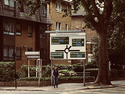
It feels counter-intuitive to head west. My general interest, my preferred territory and my familiar haunts are all in the other direction. I surface at Gunnersbury Station, now embedded in the base of a dull, glassy office block unimaginatively and innaccurately called Chiswick Tower. Across the street is the equally questionably monikered Chiswick Park - a diamond of late 1990s office developments by Richard Rogers which wear their slender white skeletons outside their mirror-glass skins. Nowhere, it seems, wants to admit that it's Gunnersbury. The grass is snooker-table short and primped, the site pristinely managed to the point of unreality. I venture in to find a tiny coffee shop situated in a free-standing oval pod, a single barista already sweltering in the metal box while she bustles through a large order for a group of Polish builders who effortlessly defy the 'No Smoking' signs across the footpath. While I wait for my drink I spot a small box sporting a bright yellow 'help' button. The sign is pitched just a little too hysterically for my liking: 'Lost? Confused? Need Help? Press here for Chiswick Park Estate Management'. As I sip my coffee in a designated seating area and make the final preparations for my long day of walking, I wonder just what kind of crises the employees and visitors to the companies inhabiting the park suffer regularly enough to warrant that kind of message? It is perhaps best not to guess - especially on a Saturday when the site is eerily and rather menacingly quiet. Instead I move on - back out onto Chiswick High Road, and just a short walk from the infamous Chiswick Roundabout.
If you've ever listened to an LBC traffic segment, you'll have heard this fairly ordinary traffic feature used as a barometer for the state of the Capital's roads. Here the M4 either starts or ends, depending on your viewpoint, while the older Great West Road - as immortalised by Chris Petit in Radio On is relegated to a supporting role, running underneath the motorway. This is also the only point where the North and South Circular roads meet, with the broadening estuary of the Thames breaking their imperfect circle where they attempt to reconvene out east at Woolwich. As I snapped a picture of the large sign on the approach to the junction, much to the amusement of some tourists checking out of the nearby hotel, I realised that at some point if I am to stay true to the rationale of my project, I'd need to suspend my prejudices and head south of the river. The South Circular was a poor relation, an inferior and unimproved cousin to the A406, running for most of its length on twisting, turning high roads through urban centres. South London has never received its due in transport terms - tube lines sputtering to a halt after barely crossing the river, railway stations closed and not often considered for reopening, and to cap it all a road network which struggles to support the population which it serves. I found myself curious about this southern exit and what it might reveal about areas I rarely visited, but, today my business was with the northern outlet from Chiswick Roundabout. It was an inauspicious start to this long journey - the footpath fringing a long-vacant, overgrown corner site and surrounded by a cluster of roadworks where the traffic funnelled into a brief stretch of ageing dual carriageway. All too soon, the traffic was crunched into a narrow four lane, single carriageway suburban route between ranks of houses. A surprise for me, as I walked today, would be discovering how many people lived directly on the North Circular and would have to negotiate pauses in the torrent of traffic simply to leave their driveways. These roadworks appeared to mostly affect the railway bridge, leading over the inelegantly named North & South Western Junction Railway line between South Acton and Old Kew Junction, with pedestrians diverted over a makeshift covered bridge beside the road. The railways of this corner of West London are complex and trying to unravel them in my head without a map was folly - but I later recalled that this line was briefly used for the 'Crosslink' service from Basingstoke to Norwich via the North London Line, finally ending in 2002. A noble but ultimately doomed effort at using the existing infrastructure in new ways - a sort of Crossrail on the cheap. As I walked and pondered the railways criss-crossing the area, I stumbled upon the wild green edge of Gunnersbury Park. My first contact with this place was via a song, a rather twee piece by The Hit Parade, which made it sound an idyllic and rather ethereal spot. I'd always suspected however that the song was something less honest - the urge of a provincial lad freshly arrived in the city to namecheck a London spot near his newly adopted student digs perhaps? Let's face it - we just can't do road songs here. The romance of Americana doesn't translate into British suburbia, and even the most esoteric name-checking of places is going to sound gratingly odd. The reality of Gunnersbury Park was a surprisingly large tract of green space, some of which had been left to become pleasingly ungoverned and unkempt. Other areas, further into the park appeared to promise the usual range of facilities, and even a museum - but I didn't stray beyond the fringe. Instead I walked the pavement outside the high brick wall, noting how few gates opened onto the busy road. The North Circular here divided briefly into two carriageways once again, a run of large but, in their marooned and straitened circumstances, faintly ridiculous mock Tudor semis flanking the eastern side. This was, to some extent what I'd expected - and as I came upon the crossroads where this important route ground to a halt at traffic lights for the first time, I realised that the haphazard, piecemeal improvement of the route since the 1920s had turned it into a curious time capsule. Walking this route was archeology rather than geography. The silt-like layers of London's development had not settled evenly around the North Circular.
Shortly after crossing Pope's Lane and wondering if this was named for the pontiff or the poet, I entered the London Borough of Ealing by crossing the Piccadilly Line making its way out to Heathrow. I'd stayed near here before for a number of rail trips which had begun at Ealing Broadway, and there was a pleasant familiarity to Ealing Common which opened out to the west of the road, criss-crossed by pathways and flanked by tall townhouses. The tree-lined crossroads where I crossed the road out to Uxbridge, once the route of the old Oxford mail coach - was particularly familiar, and the hotel I'd used sat in its familiar spot on the northeastern corner, now a rather swankier Doubletree establishment. A local festival was setting up on the green. Ealing felt comfortable and promising in the morning sunshine. This is where Hanger Lane begins - and I confess I'd been a little disappointed by this when I'd first visited. If Chiswick Roundabout is the headline, then Hanger Lane was a depressingly familiar footnote to all the worst traffic reports, the place where all journeys collapse into epic traffic snarls. Hanger Lane even sounded gritty, dangerous and relentless. It was, in fact, a leafy continuation of Ealing Common - at least at first. The road climbed slowly initially, soon becoming surprisingly steeper - living up to the name's origins - a wooded hillside. Hanger Hill was once a desirable out-of-town spot, and even after the coming of the great arterial route of Western Avenue in the 1930s and the building of several suburban estates on its slopes, it remains a sought-after area to live. As I ascended the hill I noted a broad, well-trimmed but abandoned sports ground, once home to Barclays Bank's staff leisure facilities. The large modernist pavilion building crumbled in a corner, its bold clock face falling from the wall one modern, numberless hour marker at a time. I crossed the street here in preparation for navigating the junctions up ahead and found a crescent-shaped tangle of woodland separating the estates from the road. The woodland was refreshingly cool, with waist-high nettles and tangled brambles. I felt like I'd plunged into a forest, despite cars swishing by just feet away.
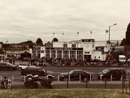
On emerging from the woods, the road started to descend into the wide valley of the River Brent, and the view which opened before me was less bucolic. Above the shimmer of fumes above the Hanger Lane Gyratory was a climbing terrain of suburbs and industry, the arch of Wembley Stadium dominant. The road reached its first major junction almost absent-mindedly - straddled by a parade of shops served by little sides streets, the confusing horror of the Gyratory came rather suddenly upon me. Marooned in the midst of the clamour was Hanger Lane Station, a sober concrete and glass drum peeking from the caldera in the midst of the giant roundabout. The network of subways serving the station also allowed pedestrians to access the various other exits, and I soon found myself on the north eastern quadrant of the junction, beside an almost identical parade of stores. That these shops could survive so close to the others was testament to how few people dared to venture beneath the junction perhaps? The A406 turned north east here, now becoming a divided highway in earnest with a solid metal fence preventing pedestrians from attempting a suicidal crossing. Walking the narrow sliver of pavement towards the fitful surges of traffic, I wasn't entirely sure the path continued ahead. So, after passing under the northern arm of the Piccadilly Line I used a brightly tiled underpass to reach the northern side of the road. The route here shares the broad valley floor with the Brent, and represents a northern boundary for the vast Park Royal business area. The area between the river and the road is a straggling mess of fringe businesses, marooned and separated from the main business park by six lanes of traffic. As such they're a strange bunch of premises: a furniture outlet with an impressive mock-colonnade entrance, a truly huge Chinese supermarket, car dealerships and a forlorn Travelodge surrounded by high fences and battered by fumes and noise from the road. Beyond this, a modern aqueduct carries the Paddington Arm of the Grand Union Canal overhead, but there is no easy access from this side of the road. Instead, stairs lead up to a footbridge suspended under the canal which allows pedestrians to switch from one carriageway to another by shuffling along under the towpath. The canal was a welcome thought - cool waterside walking was an appealing alternative to the hot dusty slog of the road - but it wasn't for today. Intrigued by the bridge I added it to my list of potential future urban hikes and moved on. Up ahead was part of the cultural history of the North Circular - The Ace Café. Opened in 1938, the Ace was a modern, bright transport café serving traffic on what was then a newly improved road with an equally modern bright future as one of London's future Ringways. The always-open Ace became a centre for motorcycle culture in the 1950s and 60s, featuring in the movie of The Leather Boys - a somewhat sanitised version of Gillian Freeman's novel of gay biker culture. Between 1969 and 1997 the building languished as a tyre warehouse and office, before reopening and once again serving the motorcyclists of West London. As I climbed up the curving ramps of the adjacent footbridge to get a view of the road, I saw ranks of motorcycles gleaming on the forecourt while speakers thundered out rock'n'roll and leather clad men sweltered in the humid late-morning. The Ace gleamed, pristine white plasterwork shining in the sun. There was something inspiring about seeing this bit of road culture surviving, a world away from the monotony of motorway service stations where you needed to check the signs because you could be anywhere. The Ace anchored the corner of the North Circular as it began to head east into uncharted territory. My footpath descended to pass under the first of numerous railway arches, the North Circular using its own, pedestrian-exclusive concrete underpass here. The service road I was using here was the entrance to Stonebridge Park station, and also to both the rail depot and Princess Royal Mail Distribution Centre. Between the bridges, looking up into a narrow band of sky, I caught a glimpse of Stonebridge Park signal box sitting high above me between the lines where Overground and Bakerloo Line trains shuddered overhead. Aside from the frequent passage of Royal Mail juggernauts, it was oddly cool and peaceful under the railway, and odd to think how often I'd passed above this otherwise unremarkable spot.
I emerged from the Victorian brick arches into a somewhat more dystopian vista. Firstly, I finally caught sight of the River Brent. Having walked in its shadow for some distance, the river finally came alongside the road in a deep concrete channel. I could smell the river before I saw it, a ripe sewage-like tang in the summer heat. Concrete walkways crossed the water to access the ground floor of Wembley Point, a 21 storey triangular tower which dominates the junction with Harrow Road. Now in mixed use, the curious ribbed concrete is clad in glistening mirror-like panels, reflecting the less salubrious view of the derelict Unisys Towers which sit on the southern side of the road. These curved concrete slab blocks have been out-of-use for more than a decade, despite various plans to reuse them. They tower over the surrounding low-rise suburban landscape and give the junction an air of the slightly off-kilter view of the future city which would have featured in mid-century science fiction. They are though, not entirely deserted, as an enterprising security guard appears to be allowing Wembley-bound punters to park within their fenced compound for a nominal fee on event days. Needing sustenance I decided to stray briefly from my route here, following Harrow Road into the almost disappeared suburb of Tokyngton. Everyone refers to this part of London as Stonebridge - or even just Wembley - but it is a distinct area in itself, even if remembered only in the name of streets and nearby parks. At first sight it's a fairly down-at-heel neighbourhood, with a long straggle of ethnic supermarkets and newsagents along the road. Two things quickly became apparent here - that I'd need to pay for my goods in hard currency rather than plastic, and that if I wanted to withdraw cash to do so I'd be paying for the privilege of accessing my money. It struck me how inequality is thrown around as a lofty, political concept just now - often measured by the gap between the ludicrous and unreal world of the football star and the rest of us - but that it really bites on this micro level. You've worked hard at a minimum wage job but to access the funds you earned in your local High Street you're paying almost a third of an hour's salary. It is perhaps this kind of built-in unfairness - high prices for pre-paid electricity, high credit charges for insurance bought in instalments, and so on - which makes the simple mechanisms of life more expensive for those who are just about getting by. Perhaps before we talk about levelling the pyramid, we should address some of this simple, functional inequality of access and actually impact real lives for the better? In the end, I left Tokyngton without making a purchase, striking out into the park which runs between the Brent and the North Circular here. Being near water, however noisome its aspect, took the edge off the increasing temperature and for a while at least my walk was surprisingly peaceful and cool. I'd planned to consume refreshments in the park, but the difficulty of buying anything on Harrow Road had scuppered that plan. Instead I ambled along, trying to capture a view of the looping arch of Wembley Stadium across the tree line. Eventually though I was faced with a choice - follow the river north, or head back east onto the road. Again I stayed loyal to my plans and found myself once again on a narrow pavement in front of small semi-detached houses which were spattered with road-grime and greyed with years of accumulated fumes. The front gardens were litter-traps, swirling discarded detritus from the passing cars trapped inside gates and along the fence line. While it seemed like a miserable existence in some ways, all of the houses were occupied and any sense of the widespread planning blight along the route which I'd read about seemed to have been driven out by the bizarre conditions in the London housing market. If this was a bargain in a relatively central zone, perhaps the endless churn of traffic out front was tolerable? Up ahead, the bright blue hulk of IKEA filled the horizon. I contemplated a visit to a strange drive-through McDonalds housed in an oddly charming red-brick roadhouse, but seeing it teeming with young families, I decided to press on towards the retail park. Finally, by way of a complicated footbridge beside the turgid, algae-filled waters of a channel feeding the Grand Union Canal from the River Brent, I found my way into a ridiculously big Tesco store. It wasn't the picnic-spot I'd hoped for, but it would suffice in a pinch. It seemed an appropriate roadside halt on the modern North Circular, where you're never far from a retail park.
Refreshed but still weary from the heat, I retraced my steps out to the North Circular. Immediately the road began to rise towards a railway bridge crossing the Chiltern Lines and the Jubilee Line. Almost directly below the bridge the lines diverge, with the broad fan of sidings entering Neasden Depot spreading to the north of the line. Pedestrians were relegated to a separate bridge on each side of the main span, the result of some earlier widening scheme. Somewhat isolated from the traffic I was able to scan the horizon, watching trains shuttling into the depot and trying to make out the various routes which split away here. As I rejoined the carriageway the road took a treacherous bend to the left which created a continued screech of brakes and a forest of red tail-lights. Almost immediately on turning the corner, the road became the frontage to another stretch of grimy but clearly occupied houses and tired businesses as I approached Neasden. Neasden is the butt of a series of Private Eye jokes - and it has ridiculousness built in from it's origins - deriving its name from 'nose-shaped hill' was never going to make it a serious contender. It was immediately clear that the substantial suburb has had far greater injustices done to it in recent times, with Neasden Lane - its main thoroughfare - divided by the North Circular into two distinct and disconnected parts. The urban centre is now bypassed by a busy underpass which linked into my route via a looping, part-cloverleaf junction squashed uncomfortably into the tiny corner of space available. The pedestrian route appears to take a long detour north, but I noticed the continuation of the path beyond a low barrier ahead and took the chance. I'm not alone, it appears to be what the locals do here too I could see, but as I cross above the bypass I spot the unedifying sight of a crumbling brown sprig of memorial flowers cable-tied to the safety fence. South of the road, the buildings along Neasden Lane stack higher as it climbs towards Dudden Hill and the green and white sign of 'Dicey Reilly's Nite Club' reminds me that this swathe of North West London, stretching roughly along the route of Roman Watling Street is home to arguably the most concentrated population of Irish folk outside Ireland. It's written that these northwestern districts were as far as the newly arrived young Irishmen could walk from Euston with their suitcases, and thus they settled here. They were indeed primarily young men - idealistic and keen to retain their culture despite needing to travel for work - and this meant that over the course of the 1970s and 80s the area took on a dangerous edge as the 'troubles' once again crossed the Irish Sea. Though primary accounts are unsurprisingly scarce and somewhat unreliable it seems likely that the area was a reliable source of funding for Republican groups during the most intense periods of conflict. While the enclave which once ran from Cricklewood to Paddington along the A5 is much diminished - in no small part due to the improving fortunes of the Irish economy in more recent times - it's a telling statistic that the London Borough of Brent still has a population of which 13% consider themselves Irish or of Irish descent. Looking along the divided community of Neasden straggling along the ridge it's hard to see the attraction to the area in some ways - but the promise of work, money and kinship was surely a strong draw.
The road began to turn east - and while it was still far from its most northerly point here, I sensed I was heading into more familiar territory. In fact I soon found myself close to the origins of a recent walk, as I arrived at the junction with Aboyne Road where a nondescript metal gate led into the parkland which separated the North Circular from Brent Reservoir. Slipping into the park I weaved around a gaggle of mothers applying sunscreen to their pramloads of children, and made for the water. The impressive sweep of the artificial lake stretched north and east, while beside me an earth bank marked the line of the dam wall where the waters of the Brent were stopped up. A busy marina filled the southern part of the reservoir, while wilder parkland was evident on the northern bank. I followed the rough path along the edge of the lake stopping to decipher the faded interpretation panels which had all been overwritten with the word 'ALLAH' in thick, black marker pen. The narrow stretch of grassland between the road and the water was a sea of wavering reedy grasses which swished pleasantly, altering the incessant traffic drone which I realised had dominated everything I'd heard for the last few hours. The path began to swing back east towards the road, and delved into a rather forbidding patch between tall and straggling trees. A pair of stolen suitcases had clearly been rifled through and discarded here, the odd ephemera of a holiday scattered disconcertingly among the branches. The path abruptly stopped at a bleak iron gate near a footbridge, depositing me directly onto the road once again. Dust and litter swirled around the alcove formed by the bridge abutments and the gateway. I wondered if it would have been possible to continue to strike out along the shore of the lake, finding my way out to West Hendon where I'd tried to access the waterside a month ago? It certainly didn't appear so - once again the North Circular was the only viable option. It is just that kind of road, it seems: a route of last resort.
I consoled myself in knowing that the River Brent wouldn't ever be far from the rest of my walk today as I slogged along the footpath beside three lanes of traffic which pulsed oddly between slow jams and high speed dashes in reaction to unseen traffic signals ahead of me. While I was focusing on the presence of the river, it was the road which would be the dominant feature of the next section of my walk as I approached Staples Corner. Here, the A5 crossed under the North Circular which rides high on a viaduct crossing the embryonic slip-roads of the M1. It's a complex mess of additions and improvements from a motorist's viewpoint, but from a pedestrian's aspect - you may as well not even try. Certainly it's clear that few do come this way, as individual footprints were evident in the thick layers of dust and detritus deposited on the footbridges which thread between the complex infrastructure of the junction. First I descended as the A406 rose between two totemic advertising pillars which dwarfed the surrounding warehouses, forming a ceremonial gateway to Brent Cross. Now at ground level, I passed under the concrete bridge carrying the A5, suddenly rather conscious of the towering stack of carriageways above me. A footbridge climbed from each side of the junction to meet in a central walkway suspended under the viaduct carrying the North Circular above everything. The competing streams of traffic shuddering around me created an impossibly complex sound which was at once both overwhelmingly loud and strangely soothing. It also had the odd effect of negating the sound of passing high speed trains on the Midland Mainline which also somehow squeezed through the junction on an old brick viaduct. As I descended to the ground on the other side of the roundabout, I faced a choice - follow what appeared to be a path under the railway or head along a side road which had been appropriated by a car maintenance establishment as an unofficial repair yard. The path soon ran out, depositing me in a position where I couldn't cross the next road which was effectively the beginning of the M1 - so I dutifully retraced my steps under the clammy arches and doubled back through the makeshift car lot, surprising the locals who clearly saw few pedestrians here. Finally I found the grubby, litter-strewn spiral ramp leading up onto a footbridge into the middle of the next huge roundabout. I was aware that I was sweating and breathing hard. The air was hot, dry and metallic and the mental effort of trying to find the right route was equally taxing. I had a dull headache and realised that my brow was fixed in a serious frown from trying to understand and negotiate this route. At times like this I suspect most people would wonder why I set out on these journeys? Why I wouldn't just get the next bus out of there? But my battle with Staples Corner was all part of understanding the terrain. There are always ways to walk these places, if you're persistent - and foolhardy - enough to seek them. As I trudged down the slope of the footbridge which brought me back to ground level beside the North Circular once again, I noticed that over the fence was the fringe of a vast car park serving Brent Cross shopping centre, the ungainly stack of buildings which glowered in the middle distance. I set off again, noting that you'd have to be pretty unlucky to need to use a space this far from John Lewis...

Passing Brent Cross took quite a while, the site straggling along the North Circular and almost using it as a breakwater to separate the shopping centre from suburbia. The margin which runs along the road is a little unloved, and perhaps not the face the stores would expect arriving customers to experience first - but almost no-one ever arrives on foot via the A406 I suppose? The long, dusty concrete service road reeked of misconnected sewage outlets and was strewn with litter from the main road while the fence was a trap for the slightly better class of rubbish blown away from the shopping centre. The layers of trash met, plastered by the breeze onto the high, mesh fence. The Fire Escape route from the semi-permanent funfair which occupies the space between mall and road was propped open, staff furtively smoking in the gap. An overloaded white Transit van attempted a three-point turn, its rusting and overtaxed bodywork almost grazing layers of rubber from the tyres as the driver swore at her inability to manoeuvre out of this bind. The Brent had been hidden inside the confines of the retail park for a while, flowing beyond the fence, but as the road curved towards its multi-level interchange with the A41 up ahead the river was again alongside the path, a deep concrete ditch lined with a glutinous layer of slippery weed and algae. I picked a way between the carriageways, not made easier by the only available signs assuming I wanted to access either the retail park or the oddly isolated branch of Toys'r'Us marooned to the south of the road. I eventually escaped, passing a rather fine old bridge over the river which was hidden beneath the dual carriageways, onto Shirehall Park which formed the spine of a decent estate of suburban houses shadowing the Brent and the North Circular. A little way further on I was able to escape the road briefly by turning into Brent Park. This sliver of wild green space follows the very first section of the Brent and the path here forms part of the Capital Ring. As such, it is at least reasonably clearly identifiable and decently kept - but it was today entirely deserted, which was perhaps not entirely unexpected. While some sections of the Capital Ring are popular in their own right, only the dedicated who intend to make the full circuit end up covering these suburban and more prosaic sections. They're missing a treat in my view - the park was cool and green, and while the shudder of the road was still evident, there was a welcome and peaceful division between traffic and footpath here. The path curved around the quiet and still Decoy Pond before heading back out towards a side-road, continuing after a crossing and a few metres walk on the pavement. And so I found myself at the beginning of the Brent - the confluence of the Dollis Brook from the north and the Mutton Brook from the east forming the rather larger river which heads south and west towards the Thames. My path lay along the Mutton Brook, passing through a tidy and well-used playground but lined with signs warning me not to enter the brook's polluted waters. Worryingly, the signs appeared to have been there for quite a while. Little had changed for the rather forlorn, reeking ditch beside me it seemed.
My path, and the Mutton Brook, passed under the thundering and shaking North Circular via a tiny tunnel, before emerging on a wide slope of grass falling away from the road as it turned east to use the brook's steeply sided valley to progress east. Walking below the road, guided by the tall gantry signs for its own impending confluence with the A1, was a surprisingly pleasant way to cover this section. Along the road a range of large, mid-century apartment blocks imposed their presence, forming the edge of suburban Finchley. I was overheated and tired, and it was with some reluctance that I scrambled up to the road again near the vast Kinloss Synagogue and once again found myself on the deserted and rarely-walked pavement beside the A406. The complex junction with Falloden Way was clearly a major pinch point on the route, as traffic was forced to a juddering halt at traffic lights. The Mutton Brook and the footpath continued as the Dollis Valley Greenway towards Hampstead, but my route lay further north. Noting the special 'hands-free' pedestrian crossings installed to let orthodox jews reach the Shul without operating machinery on the sabbath, I steeled myself for a final push along the road. The North Circular was again an urban motorway - its carriageways divided by a solid crash-fence which was carefully pitched high enough to prevent ill-advised unofficial crossings by brave or foolhardy pedestrians. The pavement was littered and broken, clearly rarely used aside from the sections near bus stops. I began to wonder about the wisdom of starting this walk - feeling painfully aware that I ought at some point to finish at least one of these odd projects which I begin so publicly. The temperature was above 30º and I felt far more fatigued that I'd expected at this point in the walk. Everything I was wearing was drenched with sweat, and there was a film of dust in my mouth with an unpleasantly grimy taste. Fortuitously, a green strip appeared between the path and the road, where trees leaning over from the green space on the edge of a housing estate, shielded me from much of the sun. Grateful for the shelter, I put my head down and walked - determined to get as far as I could today to improve on what I felt had been disappointing progress. Looking up as the path rose, I realised that the red-brick walls beside the road were familiar - and as my path climbed away from the traffic I noted I was at the point where the A504 crossed above but didn't intersect with the road - a spot where I'd been just a few weeks ago. The A406 entered its tunnel, pedestrians officially excluded - thankfully - and I crossed the familiar route near the bus turning circle and little garden where I'd paused so recently. I thought about giving up here - but I knew that transport options weren't ideal from here. Not least because I'd need to get back to this point soon to continue the walk. Instead I walked above the line of the tunnel, marked by the edges of the garden, and was soon descending again onto the deserted roadside footpath where a row of fir tree saplings struggled to survive on the grassy median. If they made it, this path would become an invitingly cool green alleyway - but now it was the same dusty swirl of litter which had typified much of my walk today. The path wove around the ramps to a footbridge leading to the suburban streets away to the south, and then crossed the forecourt of a BP garage. I could see that up ahead the path entangled itself confusingly between the slip-roads leading to the A1000 - the route of the original Great North Road before the new A1 was constructed. This seemed like a fitting place to leave the North Circular for now, and I gratefully snapped a picture as a reference for my next walk, before following the curl of the path to the bus stop on Squires Lane. I was aware while waiting in the surprisingly busy bus queue that I was drenched, red-faced and grimy from the road - but I'd also completely stopped caring. I found a seat on the mercifully cool bus to Highbury and Islington and pondered my next move.
Reflecting on beginning this perhaps absurd project, I realised that it had been on the cards for some time - it had begun with my frequent encounters with the North Circular on my walks, and was cemented by my curiosity when regarding the mysterious Rookery Path in Woodford at the end of a recent trek. Indeed the whole concept of my ill-conceived London's Other Orbitals project meant that I had to do this at some point. If there were paths and parklands, triangles of open space and curious river valleys along the way, it would make for an interesting journey crossing suburbs in a way that almost no-one would normally choose on foot. Attempting it on one of the hottest days in an unpredictable summer was perhaps a mistake - but I have to take my chances, and my walks, when I can - and perhaps there were no perfect conditions to attempt something like this? In any case, I was glad to have left the dusty, noisy road for today - but I was oddly drawn back. The next section would link together new vistas with parts of the route I'd already visited and that was oddly appealing. As my bus rumbled south, crossing the busy and colourful churn of Seven Sisters Road, I felt an awfully long way from the primped, managed banality of the Chiswick Park office development where this had all begun. Despite the trials which this first section of the North Circular had presented, I was strangely excited to get back to the road soon. A little later, as I idly researched some of the areas I'd walked on the train home, I stumbled across a passing mention of Louis MacNeice and finally, after a good deal of digging, I found the brief quotation below among the text of the long poem. And with the thrill of a new discovery of something which had - to me at least - lain hidden, there was no doubt I'd see this walk through.
The next day I drove by night   Among red and amber and green, spears and candles, Corkscrews and slivers of reflected light   In the mirror of the rainy asphalt The North Circular and Great West Roads   Running the gauntlet of impoverished fancy Where housewives bolster up their jerry-built abodes   With amore propre and the habit of Hire Purchase. The wheels whished in the wet, the flashy strings   Of neon lights unravelled, the windscreen wiper Kept at its job like a tiger or a cricket in a cage that sings   All night through for nothing. Factory, a site for a factory, rubbish dumps,   Bungalows in lath and plaster, in brick, in concrete, And shining semi-circles of petrol pumps   Like intransigent gangs of idols. And the road swings round my head like a lassoo   Looping wider and wider tracts of darkness And the country succeeds the town, and the country too Is damp and dark and evil.Louis MacNeice - Autumn Journal (xiv) - 1939
You can find a gallery of images from the walk here. The walk continues here.
A little after arriving home from this trip, news began to filter through of the terrorist attacks on London Bridge and at Borough Market. It was hard to map the scenes of quiet, empty desolation on the deserted bridge after the incidents with the busily confident, confusing and bewilderingly colourful London I'd walked across just hours earlier. Whatever people of varying political stripe will tell you, London remains one of the freest and most diverse cities on the planet, and benefits to an almost unmeasurable degree from this. With this freedom comes the opportunity to change and reinvent places, communities - and even ourselves. However, along with diversity and constant change comes an ever-shifting level of equality and sometimes a sense of alienation too. But all any Londoner needs to do to be part of something bigger, something sustaining and ever surprising is to step outside and walk in their city. London isn't an inert state capital for display purposes only - it is the sometimes confusing, often gritty and ever-remarkable product of the collective striving and will of eight million individual souls - and that's exactly why it's going to be very, very hard to repress the spirit of the city. This post doesn't stray even close to the parts of London which suffered at the hands of ideologically driven, hate-filled terrorists today - but it crosses the paths of many of the people and communities who make this city the complex, bewildering and captivating place which has consumed my enthusiasm and attention for so many years. I'm moved to remember again the word carved into the southern pediment of St. Paul's Cathedral - Resurgam. I shall rise again.
With a degree of childish excitement I descended to the Thameslink platforms at St. Pancras International station. I realised as I planned today's trip that I'd never caught a train from these platforms - at least not in their current incarnation. When my more regular travels fell away during the latter part of 2012, the line remained divided - with ongoing work at London Bridge and Blackfriars before it would be possible to restore the cross London link. Indeed, on some weekends even now there is no through service as capacity improvement work continues - but today I was lucky, as everything was running smoothly and trains were passing through the city unimpeded. I didn't have long to wait on the thankfully cool platforms under the main concourse for the train to arrive - a long, white, businesslike Class 700. I hopped gleefully on board for the short ride up to Hendon, thrilled to be getting a new type of train under my belt - a rare enough experience these days. If this walk had been planned or thought through with any rigour, the theme might well have been 'my nerdiest obsessions' - though I'm equally aware that could apply to almost any of my wanders nowadays. This one however swiftly progressed from trains to roads as I disembarked at Hendon where the Midland Main Line is sandwiched into a narrow gully alongside the M1 as it accelerates away from its origins at Staples Corner a little to the south. Hendon station is situated at a point where the A504 divides to begin - or indeed end, depending on one's perspective - on the A5 at a broadly looping one-way system. I decided that to properly commence this walk I needed to circumnavigate this as a sort of ritualistic beginning - so turning my back on the motorway and the station I set off downhill.
Hendon is a place with multiple, distinct urban centres based around transport infrastructure - and at some point there was a busy string of stores along the A5 near the station. Now, with Brent Cross Shopping Centre a stones' throw to the south and some sizeable retail developments stretching away north along the road to Edgware, the whole area looked abandoned and dilapidated. The junction where Station Road meets the straight, broad course of Roman Watling Street is pedestrian unfriendly and confusing, traffic turning left to loop right. While here I decided to venture across to look at Welsh Harp Reservoir - a fascinating feature of the map of London from my childhood. To get to the water, where the Silk Stream and the Dollis Brook meet to form the more substantial River Brent, I had to cross a new housing development which was slowly climbing around tall cranes. But surrounding the foot of the new homes were a range of mid-century public housing blocks in a fairly surprising still clearly in use despite their disrepair. A large 'Show Home This Way' banner was stretched across the entrance to this little enclave of homes, rather pointedly amplifying the difference. A little research indicated that this was the West Hendon Regeneration project, and that the process of moving tenants out to build new homes had not always run smoothly, and had rarely served the existing tenants well. This wasn't new - and it wasn't the first such situation I'd encountered on my travels in North London - but as I watched a Police Officer go door-to-door at the old, run down flats while her colleagues meticulously searched the communal waste area, I realised that like elsewhere this just wasn't working for West Hendon - a place which had little identity and even less access to services. Thwarted by barriers and the need to 'officially' be in the new development to reach the reservoir I turned back, keen not to attract the interest of the Police this early in my walk. As I traced the beginnings of the A504 via the poorly-marked junction, back to the station, I knew I needed to come back this way at some point to unravel the waterways which marked the increasingly forbidden boundaries of this area.
Realising that despite an early start to the walk I'd barely set off, I strode swiftly uphil from West Hendon, crossing the railway and the M1 again near the rather fine old frontage of the Midland Hotel. After a gritty, urban beginning the A504 soon becomes a rather typical, and certainly not unpleasant North London suburban road. This stretch is lined with decently sized brick villas, and is busy with local traffic making exactly the unremarkable local journeys that I'd imagined I'd be writing about when walking these routes. And just like all of these cross-routes, the road soon meets one of the venerable arterial routes leaving the city - in this case the wide, busy dual carriageways of the A41 heading for Watford. In fact, this road seems to carry more of the burden of city-bound traffic than the A5 which I'd crossed earlier. In the midst of the carriageways was an isolated and forlorn war memorial which I reached after a struggle through confusingly unsigned subways. The paved central island doubled as a works compound for some apparently yet-to-be-realised improvements, and it was hard to conceive this location among torrents of traffic as a peaceful place of respectful contemplation. There was a hint of a fine aspect south over the valley of the Mutton Brook below, but the overgrown trees and tangle of equipment didn't allow a good view. I headed back underground to complete my crossing of the A41 and head onwards. Altogether quieter here, the A504 takes a sharp turn to the east among the buildings which form the Middlesex University Campus. The sizeable buildings occupy a mixture of impressive newly-built accommodation and former municipal technical college premises which sit alongside the impressive civic architecture of Hendon's old Town Hall and Library. The former Middlesex Polytechnic brought together a somewhat disparate range of much older teaching institutions across North London, finally coming into some sort of coherence in 1973, but still ranged across a number of sites dotting the North Circular. In recent years, the University has settled on a strategy of centralising on the Hendon Campus, and developing some smart new buildings alongside the rather fine civic centre it occupies here. It struck me that if my orbital walks had a patron educational institution, it would be Middlesex University, its scattering of former sites marking out my recent walking territory with eerie accuracy from here to Cat Hill, Trent Park, Tottenham and beyond. Turning my back on the large emblem of the now-defunct County, I press on eastwards into what may well be called Church End - a curiously unremarked urban centre which sits marooned in a diamond of suburbia trapped between the A41, the A1 and the North Circular. It was proving to be a hot morning so I loaded up on water before moving on, crossing the bustling crossroads of Church End and following the signs for Finchley.
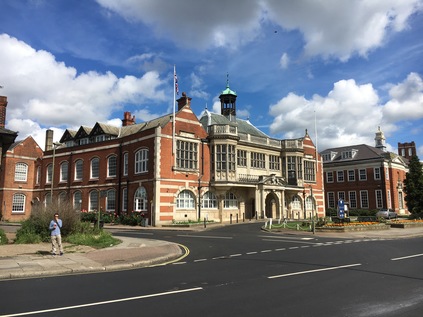
Plunged back into typical suburban scenes, I noted the road beginning a gradual descent into the Dollis Valley. Ahead of me, a tree-lined ridge indicates a climb beyond which I'll need to tackle soon - but for now I focused on the crossing of the 'new' 1920s alignment of the A1 in the valley below. The road network of North London uses the geography of waterways as a framework, fitting into the harder to develop valleys and gullies the brooks and rivers have formed over millennia. In particular, the confluence of the Dollis Brook and the Mutton Brook provides the opportunity for the A1 and A406 to entangle in the messy, complexity of Henley's Corner. The waterways have had their last laugh perhaps though, as this complicated and congested junction is now hemmed into the confines of the site, and very hard to modernise or expand. My route crosses the A1 north of this tangle, in a rather gloomy hollow at the foot of a hill. The busy road is fringed with houses and service roads, a fume-blackened anti-pedestrian fence along the central reservation. Immediately after the crossing I'm on a bridge over the Dollis Brook, a broad and proud stream which unfortunately, today at least, reeks of sewage and decay. There is a pleasant looking path alongside it, well-signposted and inviting. I log the details for future wanders and press on uphill along Finchley Lane, a long and slow climb through fairly featureless residential streets. Along the way I spot the bus stop for 'Crooked Usage' and can't relate it to any local streets or features at first. Curious to research the unusual name later, I snap a picture and move on, feeling the net curtains of Finchley twitching behind me at my brazen display of odd behaviour. It is perhaps premature perhaps to say Finchley though, as I'll never quite get there... My route makes a sudden turn south along Gravel Hill to a crossroads with another road to Finchley which the signs also claim is the A504. No maps seem to agree, so after spending a moment pondering whether the completist in me needs to make a detour along this spur, I resolve not to be diverted. Thatcher country can wait for another walk along another road. Instead I continue into the rather prematurely named 'East End Road', a considerable length of which fringes a Cricket training ground named for Wilf Slack - the Gambian batsman who thrilled Middlesex fans in the 1980s before a shocking early passing. Across the street from these well-kept greens is the New North London Synagogue. I'd noted the smartly turned out families across Hendon and Finchley heading for their Shabbat morning services, but this was an altogether larger enterprise, attracting a seemingly much bigger congregation. I also noted the presence of considerable security along the high brick wall which fronted the site, and only a sense of decorum prevented me from photographing the curious site of a muscular, white-shirted guard cracking his knuckles menacingly in a stab vest and a yarmulke. There was a sense of tension alongside the fine clothes and family groups this morning which was sobering to a visitor from the comparatively rural west country.
I could hear the rush of fast-moving traffic up ahead but the source wasn't immediately evident. As I approached a deserted bus loop and a windswept public park, I realised that the tunnel carrying the North Circular was directly beneath me. Crossing to the southern side of the road, I could see the broad carriageways emerging from a surprisingly decorative brick tunnel mouth with Middlesex county crests built into the brickwork. I paused a while to contemplate the walks which I'd need to undertake to cover this lengthy, deeply polluted beast of a road. I'd navigated considerable parts of its tortured circuit on foot already, and it had been a constant presence in my walks over the past year or so - but it needed to be considered as a whole at some point. I figured it would all too soon be time. But now I had other business, and pressing on alongside the huge East Finchley Cemetery - which seems to have a tennis club embedded rather optimistically within the grounds - I entered a somewhat gentrified zone leading into East Finchley where the older route of the Great North Road crossed my path. As people strolled around with purchases from the rather fine butchers shop and bakery, I spotted a young gent in rather snug shorts using a state-of-the-art cordless vacuum cleaner to hoover up stray gravel from his driveway which also featured a huge 'Vote Labour' sign. It felt like a defining image for the maelstrom of an election campaign which was being waged across the country now. None of the parties seemed to occupy their rightful places just now. All was confusion. Blame Brexit, blame immigration, blame everyone except the often wilfully perverse voting public. East Finchley becomes Fortis Green - which may or may not be an suburb in its own right - and hereabouts the London Borough of Barnet gives way to Haringey. Not a great deal changed - the long straight road was lined with pleasant terraces, the occasional set-back cottage behind a leafy hedge, and local businesses and pubs. Traffic was a little quieter here, and only the occasional TfL bus stop reminded me that I wasn't in almost any other provincial market town. As I continued east, a sense of London returned in the long parades of victorian shop fronts and sizeable blocks of early public housing schemes. The broad avenues leading south from Fortis Green led towards a distant vista of Highgate Wood, a splash of green under a cloudless blue sky. It was easy to love these surroundings, and I'd have happily walked here for longer hadn't the call of coffee been strong. I was approaching Muswell Hill - a district I'd briefly skirted when walking the former Northern Heights railway line, but which I didn't know well. As I was following the A504, my approach was via Queens Avenue - an impressive crescent of terraces which were clearly far too big for modern dwellings, and which had been divided into flats some time ago. The splendid buildings looked decently built but sadly run-down, a forest of wheelie-bins cluttering the front yard of each, and a truly remarkable amount of fly-tipping in evidence. As I marked the curve towards the centre of Muswell Hill, stepping over microwaves and around mattresses discarded on the pavement, I wondered if perhaps my preconceptions about the area had been wrong after all?
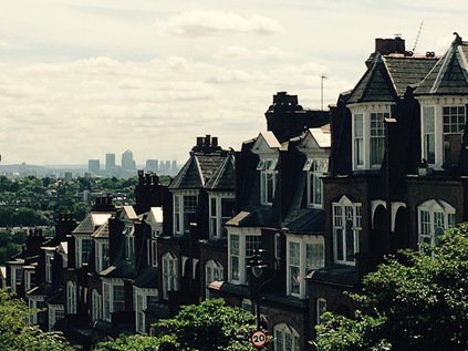
They hadn't. Once I reached the epicentre of Muswell Hill - focused around a five spurred roundabout housing a bus stand - I saw that it was just as I'd expected. This bustling zone was a distinct small town, and the crowds which wandered in the midday sun were predominantly almost sickeningly happy, healthy and prosperous looking young families. As fathers hefted curious children onto their shoulders to sway through the crowds, a loud and engergetic Labour Party campaign stand was drawing attention. Hornsey and Wood Green has flipped between the main parties over the thirty years that it has existed in its current configuration, but it seemed that local activists were doing their utmost to see that Catherine West held on this time. I explored the town centre a little, until I found a coffee shop and took a quick break in the cool, dark air-conditioned comfort. Outside, the electioneering went on as loudly as ever. For the first time in this short, sharp and rather bitter campaign I began to doubt the result would be as clear as it had seemed at first. Moving on, I took the south-eastern exit from the huge roundabout and confronted Muswell Hill - the steep, long road leading down from the northern heights towards the lower-lying lands around the Lea Valley. Reputedly the steepest hill in London, it commands an impressive view towards the Isle of Dogs, and I tried to capture it on camera before realising that I wasn't going to do this scene justice at all. Instead, I gingerly set off - walking downhill is of course always preferable to heading up, but it has its own special perils for a clumsy, heavy footed walker like me. I took things steadily, letting gravity do just enough work - and working hard to stop it doing more than I'd like! Soon after setting off down the hill I spotted the underpass where the former railway crossed under the hill on route from Alexandra Palace to Cranley Gardens. Muswell Hill is surprisingly ill-served by rail nowadays, and while it figures in a good number of bus routes, it's a hike from the nearest station. Perhaps, given the evident prosperity in the area, the Northern Heights plan hadn't been such a bad one after all? I continued down the hill, the impressive front of Alexandra Palace appearing over my left shoulder, with the tall antenna pricking the blue sky beyond. My last walk here had been misty and strange - but I hadn't quite appreciated how fine the views were from up here. Beside me, cyclists struggled against the gradient, determined to make the ascent in one effort. After reaching the bottom of the hill with a little relief that I'd done so firmly on both feet, my route turned east towards Hornsey. This was an area that I had only a theoretical sense of - a railway depot, a former Borough, a station. Haringey is always described as a borough of contrasts - and the first noticeable difference was that in this lower-lying eastern part of the area, the population was far more diverse. The sea of almost entirely white faces up on Muswell Hill now seemed rather oddly homogenous. The area was also however, much less prosperous looking and felt a little down-at-heel. Street furniture wasn't repaired nearly as consistently, there were more empty shopfronts, the streets were less well-cleaned. The benefits of living in a vocal, educated middle class suburb were starkly apparent - but Hornsey High Street went about its business with pride too, and I confess to feeling much more comfortable ambling along this stretch of curious stores and patches of unexpected green space than I had while lingering in Muswell Hill. At the end of the High Street, the road passed under the East Coast Mainline with the New River skirting the foot of the viaduct. To the north, the river ran in pleasantly landscaped surroundings with new offices and apartments set among the buildings of the Victorian pumping station. Beyond the road to the south, the river disappeared into a graffiti-covered underpass surfacing east of the railway. The temptation to turn north and walk the river path was strong as ever, but having passed the midpoint of this route there was no way I'd turn aside.
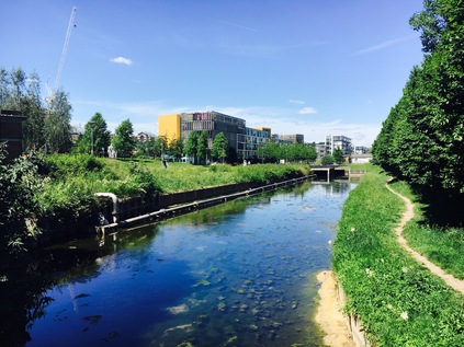
From the bridge, my path continued east as Turnpike Lane - a long terrace of victorian villas fronting up against a run of cash-and-carry outlets and restaurants. Some of the terraced homes had built their fronts out to the pavement forming makeshift stalls selling exotic fruit and household appliances. The street throbbed in the heat, low beats shuddering waiting cars while people hung around on the pavement, far too warm to be in the heat inside their premises. Glancing along the streets leading north as I crossed them, I spied the totemic 'M' which topped the Mall at the former Wood Green Shopping City. It dominated the surrounding area in an oddly menancing way, breaking the suburban pattern. This also meant that I was nearing the crossing of Green Lanes at a spot I'd visited on a number of occasions. Not least when I'd traced the mysterious Moselle River in so far as it can be found nowadays. The origins of this stream in Muswell Hill weren't lost on me during todays walk, but it's hard to imagine where it might have flowed before the arrival of this busy jumble of streets. The junction of Green Lanes - or at this point Wood Green High Road - with Turnpike Lane was as ever a chaotic and frantic tumble of people. It was hard not to get swept up in the crowd, carried across the road and into the Underground station with the greater mass of people. Young shoppers laden with bags tottered along, achieving one-thumbed text message composition as they went. Drivers edged around the corners of the junction as pedestrians blindly strayed into their path. Buses shuddered and lurched away from the stops, urgently sounding horns at people who just couldn't wait to pass in front of them. Despite following a suburban A-road, here the pedestrian had asserted unofficial authority. I turned south then west, passing the routes I'd taken before in pursuit of the river, and heading into West Green Road. This involved crossing an area of the map I'd not traversed, closely shadowing the former Palace Gates railway line which had branched from the Great Eastern Mainline at Seven Sisters. I realised as I progressed along a suburban street not hugely different to others I'd encountered today, that I'd only ever crossed this zone between the main arteries of Green Lanes and Tottenham High Road by rail, despite walking the radial routes into the city many times. Perhaps this series of walks which cross the territory are long overdue? West Green was in some ways a revelation - a large African and Caribbean community made for a bustling, loud and surprisingly interesting walk, the suburbs soon giving way to a busy if officially unremarked High Street where a dizzying range of cuisines and ingredients could be found along with a vast over-provision of barbers, phone unlockers, money wiring services and apparently makeshift garages. Along the way I paused close to the sliver of Downhills Park which reaches south to the road along the old railway curve, and listened to an animated preacher belting out her witness near the war memorial. Meanwhile, across the street the congregation of the Seventh Day Adventist church were spilling into the street - a busy tumble of beautifully dressed people filled with fervour and excitement which the church, apparently converted from a suburban home couldn't contain. It was time to make once last push into Tottenham and beyond - but I was almost sorry to be leaving West Green where life appeared to continue regardless of London's swirl and bluster just on its fringes. Spotting a tell-tale rise in the road, I briefly detoured south onto Avenue Road where a bridge parapet still betrayed the route of the Palace Gates branch, now in-filled with modern low-rise housing. Further east, where the rails from Liverpool Street crossed above, the site of the former entrance to Seven Sisters Station was evident, a tumbledown newspaper shack occupying the old stairwell. The entrance had moved to more salubrious streets when the Victoria Line arrived in 1968. West Green, marooned between railways but with no station of its own, persisted nonetheless.
I crossed Tottenham High Road near where my recent A503 walk had intersected it at Page Green. The reputed site of the ancient ring of trees known as the Seven Sisters now housed a ventilation shaft for the Victoria Line, the trees clustering around it in a mockery of the legend. Broad Lane continued the A504 beyond the High Road into the surprisingly quiet hinterland. I could sense the River Lea close by, my route having flattened out as it crossed the wide floodplain. Traffic was sparse, and apart from an eager religious leafleter, I was one of only a few pedestrians out in the strong sunshine. With industrial buildings looming ahead, the road took a sharp turn to the north and suddenly I was in the familiar territory of Tottenham Hale Retail Park. The shiny metal and glass units reflected the heat back at me as I passed between them, noting that on the other side of the street an old fashioned second hand shop was doing fine business on a corner. At Tottenham Hale station, my road ran out - merging into the A503 as it ploughed on over the Lea towards Epping Forest - a route I'd already taken. Navigating the complicated redevelopment of the station to find my platform, I reflected on my walk as I waited for a train back into the city. Hendon seemed so distant and alien to this familiar landscape - but on the way I'd passed through what seemed like unremarkable suburbs, all of which had left surprisingly individual and different impressions on me. The gradual ascent to the heights followed by the sudden descent into the Lea Valley felt a little like coming home - back onto comfortable territory - but it suggested so many other walks which called for attention. As the country sat on the brink of an unexpected election, basking in an equally surprising summery weekend it was hard not to feel a little flash of optimism for London and its future. The train was late, but I was happy to spend a few more minutes watching the world pass by out here.
A gallery of images from the walk can be found here.
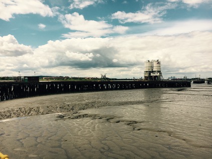
New Islands and Old Idols - Blackwall to Dagenham
Posted in London on Saturday 20th May 2017 at 10:05pm
The luxury of waking in London wasn't lost on me this morning. As I tramped towards an early breakfast which I took with a view over the Tower of London and bright sunlight glaring off the panels of The Shard, I pondered the day ahead and its odd division between places old and new. I've walked and written about London and its environs for years in some way, but there was a distinct tempo change in 2012 when I felt like the city was on the brink of its next seismic lurch into the future. It was a tumultuous year in many ways - in London, in the wider world and in my own life - and I noted a distinct shift in how I was thinking and writing about the city. My rambles became longer, and with them my ramblings grew too. I also began to circle further and further from the well-beaten tracks in the centre of the city. Slowly, chaotically, and in sometimes stuttering steps I grew to knew the fringes of the city which I'd previously only experienced from the windows of passing trains. When my sense of adventure failed me and I felt I'd pushed the boundaries far enough I'd scurry back to safety to scratchily write up a breathless account of my walks. For the first part of my day, I'd decided the time was right to revisit some of the locations where I'd begun to explore the edges of the city. Breakfast done I hopped onto a No.15 bound for Blackwall and followed the familiar route of the A13 out of the city and into Limehouse. There was enough cool breeze to prevent the morning from being too hot, and I wondered why I'd bothered loading my coat into my bag. A quick stop on Poplar High Street for provisions and I set off into familiar territory...
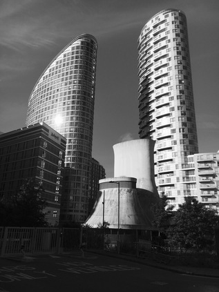
I remember lingering longer than I'd planned in Blackwall on my last visit. I'd been struck by the new city of towers rising on the fringes of Docklands, leering over the elevated DLR tracks and the angular horseshoe of Robin Hood Gardens. I hadn't expected the shift in scale between Poplar High Street and these new developments and today, with many of the cranes gone and the towers looming towards the impossibly blue sky, the effect was even more surprising. I found myself wheeling around snapping pictures of the curious views again, realising that I was probably duplicating many photographs I'd taken before. On my last visit I'd sought the river - but the aim this time was to cut across Blackwall to reach Leamouth. I was soon at the familiar roundabout at the foot of the Lower Lea Crossing - a bridge I'd seen as an impassible barrier at one time. I thought back over the many barriers I'd considered the end of London over the years, and how dark and empty the map of the East had seemed at first. Now it was rich with meaning and experience, and this felt like a gateway rather than a barrier. Today though, I didn't need to take the crossing. Slipping away beside the arc of the bridge, I headed towards Orchard Place. The urge to detour into Trinity Buoy Wharf again was strong, but there was somewhere I'd not been able to get to on my previous visit - one of the many inaccessible sections of the Lower Lea which had been, for myriad reasons, been put beyond limits for the pedestrian. Now it was, nominally at least, open again. To reach my goal though, I needed to navigate City Island - London's 'newest island' according to the glossy displays of happy, wealthy people grinning manically at each other along the wooden hoardings that still enveloped a large part of the site. In truth of course this is neither an island, nor in the city. This isthmus, one of the bulging diverticula which contort the Lea as it becomes Bow Creek, had been a place of considerable industry: glass, paraffin, plastics, naptha, tar and finally hydrogenated fats. The industries which had shadowed Orchard Place shared a couple of key characteristics - pungent fumes and lingering toxins. Now, as I tried to navigate around the entrance to the site without trangressing on some unwritten regulations which the security staff appeared to want me to obey via psychic divination, it wasn't hard to imagine the clutch of chimneys emitting a pall of darkness - the new towers rising on the peninsula stood in for them remarkably convincingly. I shuffled into the main square where the developer had, in lieu of any other stores this side of the river, set up The Grocer. What was dressed in the livery of a high-end emporium was really an expensive corner shop, with an attached but closed restaurant. A few other walkers, apparently from the blocks already completed on site, joined me as we followed the authorised route out to the western edge of the bulge in the river, following its curve towards the new bright red bridge to Canning Town. Across the water I could see the path along Silvocea Way leading to the footbridge I'd crossed before, standing beside the old iron bridge which seemed to rust even more before my eyes. I soon reached the stairs and lift leading to the tall new bridge, hanging back long enough to have the freedom to take pictures without annoying the locals. From the deck of the bridge I had a broad sweeping northern view dominated by the A13 crossing the Lea and the silhouette of Balfron Tower. Looking back towards the 'island', the knot of new buildings eclipsed the sun, the blocks unlit but bathed in a bright halo. I descended to the far bank near the rotunda leading into Canning Town station. Here I headed along the previously forbidden path on the northern bank of the river. My plan was to cross the DLR via an austere, metal-gridded footbridge and head into the industrial zone which lined the valley floor, but once over the bridge and on the descent to Wharfside Road, I noted the gate was locked at the other end. I could retrace my steps over the rails and trek around the long looping path through Bow Creek Ecology Park, or I could head out into Canning Town via the station and regain my route from there. Amused that finally accessing Orchard Place had led me to this rather pointless barrier, I headed for the station. It seems there was one sanctioned route off the island: directly to the transport interchange without looking around for fear the true nature of the river might be divined. God forbid that the new islanders found out what horrors lurked on the northern margins of their new home, or strayed east to ill-governed Rathbone Market. The island was a defensive position, surrounded by potential danger.
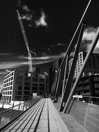
I carefully negotiated the complex crossings of Barking Road. Here the more recent course of the A13 thunders overhead to bypass Canning Town, while its old route continues an ancient eastern line towards the Roding Valley. The junction was a windswept and dusty spot, but I knew conditions would only get less pleasant as I continued in this direction. On the corner of Stephenson Street, much improved by a new road surface replacing the cracked and chemically melted tarmac I'd stumbled over before, was a convincing Paris Metropolitain entrance set into the wall. This curious doorway led into the location of the most recent Secret Cinema event - and it seems that somewhere in the apparently abandoned branch of Carpet Right was a recreation of Belle Epoque era Montmartre. There was no external evidence of this as I headed around the corner into the long, straight channel of filth which continued north towards West Ham, flanking the railway tracks. It was almost reassuring to see that this area hadn't changed a great deal. The Durham Arms still continued in almost invisible business on the corner behind unwashed net curtains, while the tottering stacks of old delivery crates and tractor tyres threatened collapse onto the abandoned Black Cabs and dumped cars with their locks drilled out. The same slow parade of out-of-service buses bucked along the uneven road, kicking up clouds of reeking dust from the dry surface. This area had tested my resolve on my last visit - I'd felt unwelcome and entirely beyond my comfort zone - but when I considered some of the terrain I'd blithely crossed since, I almost laughed at this bit of textbook liminal edgeland. Still, I wasn't unhappy to turn west onto Cody Road which was comparatively quiet and free of dust. I knew that Cody Dock wasn't going to provide access to the river, so instead I made my way into the surprisingly primped and tidy Prologis Business Park, passing the ever-unmanned security point with far less trepidation than before. Here, between the vast bulk of the Sainsbury's Online Fulfilment Centre and the Amazon warehouse, I found the narrow path which led to the bank of the River Lea. At the end of the path a broad arc of benches doubled as the smoking area for the warehouses, a ring of spent butts and ash encircling each seat. The views up and down the river were arresting, as new ways of looking at familiar sights often seem. With both banks largely inaccessible here, I'd only ever approximated a walk along this stretch of the river via nearby roads, and seeing Bow Locks ahead from this unusual angle was disorienting. I continued north: the path was apparently little used and crunched pleasantly beneath my boots. The path is perhaps so poorly used as it doesn't yet go anywhere useful, but slowly the links are being made. The steep but functional Twelvetrees Ramp now finally allows access from this new stretch of path onto the older route between the Lea and the Navigation without a long detour north or south along the Blackwall Tunnel Approach Road. I descended to the familiar route to Three Mills, walking between the waters with the railway bridge reflected from above. I was on well-walked and pleasantly familiar territory once again.
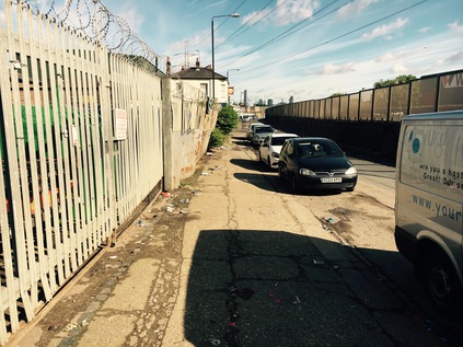
Three Mills Green seemed surprisingly quiet given the weather, but it was of course still early. I took a break here, picking a bench with a view north towards the gleaming steel and glass skyline of Stratford. Every time I passed through, the cluster of towers seemed to have multiplied, and the expansive view north along the Lea Valley seemed to be hemmed in by development. Set against the clear skies though, the city appeared striking and definite - a reality which I'd doubted it would ever achieve when I'd tramped over the dust of the site after the Olympics. After watching a pair of dedicated joggers circling the park for a while, determinedly avoid getting drawn into some sort of low-speed race, I headed towards Three Mills Lock. For years, the bridge here has been a boundary, First LOCOG, then Thames Water - authority has forbidden any access over the bridge and to Long Wall for around ten years. Indeed the nearby at Short Wall path was still blocked near its entrance - though it was less clear why or by whom. I'd read recently that Long Wall had opened again, and given my unusual itinerary today I decided that this missing link would be a fitting target for the first part of my walk. My heart sank at seeing notices with Thames Water insignia stationed at the entrance to the bridge - but these were in fact declaring the way open - ominously for 'the foreseeable future' at least. I crossed the bridge, looking down at the modern, concrete lock from a new angle. I wondered too when it had last opened? Built to enable a sustainable supply chain for the Olympics but never used to let a single barge into the site, the impressive control cabin still appeared to be staffed at times - the detritus of human presence clear in its high windows. At the end of the bridge the path turned a hard right to follow the eastern bank of the Prescott Channel to its confluence with the Channelsea River. Walking this bank seemed strangely defiant after being denied for all these years. The path plunged into the untamed woodland which fringes these rivers, allowing occasional glimpses towards the railway and the gasholders beyond. The Long Wall path was little more than a simple stony track under the trees skirting the former Lee Tunnel building site. It was surprising cool under the green canopy and I slowed my pace to savour this short respite from the noise and dust of London. I'd worried that this short stretch of path would be an insignificant reward for years of waiting - but it wasn't necessary. This was another fine reason to lurk in this strange, disembodied part of London. The path divided, allowing me to take a lower route, nearer to the water. Across the Channelsea was the long island which divided it from Abbey Creek, the strange derelict buildings I'd spied on the aerial photography suddenly real and present. Beyond the creek, Channelsea House rose to dominate the view, much refurbished and not as baleful and desolate as formerly. My path opened into a broad concrete platform where thick, curved iron pipes leapt from the ground to join the Northern Outfall Sewer up ahead. A well made slope took the path to join the Greenway, passing the brightly painted snail-shell turbine casing which I'd seen years ago from the bridge. I was sorry to be at the end of this new path, and almost at the end of this revisiting of the area. It was time to head for West Ham station, a short walk along the sweltering dust of the Greenway.
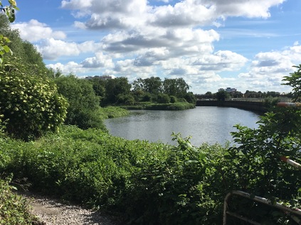
Given my extended day in London, I'd decided to take in another guided walk - this time based around the Industrial history of Dagenham. I've written before about my hesitation in taking guided walks and how I sometimes feel uncomfortably constrained by the idea. But based on the experience of the last trip with Rob Smith as a guide and since I'd had free rein to wander since early morning, today seemed like a good opportunity. Like Rob, the area south of the A13 on the map has been an empty white zone for me and attempts to explore have faltered on the simplest of questions: am I really allowed to be here? The dominance of the Ford Motor Works makes the boundaries hazy and amplifies the always present sense of alienation that these zones create. I'd passed through on the train, or cruised above on the road, and I was none the wiser. Hence the promise of a five mile slog via the white zone to the Thames sounded like a fine way to spend an afternoon. I made a leisurely progress to Dagenham Dock station where I found the group already assembling in the strong sunshine. It wasn't yet noon, and the threat of rain which had forced me to stuff my bag with a coat felt remote. I confess I'd never expected my excursion into the wild, filth-strewn industrial estates of Dagenham to begin with a liberal application of sunscreen, but it was certainly necessary today. Once the group was accounted for we set off, crossing the railway and pausing on the bridge to survey the extent of the Ford works, and to consider its part in the history of equal pay for skilled women workers. Though only greatly reduced activity continues on site, the breathtaking sweep of land which was once dedicated to the manufacture of motorcars was still evident in the abandoned buildings and scorched earth of newly cleared sites. The plans for this area still focus on employment and industry, but with an emphasis on green technology which will at least justify the costly remediation of this poisoned ground. Climbing down to ground level we passed under the concrete viaduct of the A13 before heading down the arrow-straight Chequers Lane towards the river. Buses reaching the end of the line on route EL2 lazily looped around at the end of the road before returning to Barking and Becontree, unsurprisingly running empty for this stretch on a quiet Saturday afternoon. We followed their dusty trail towards the junction with Choats Road, passing the end of Breach Lane. I'd hoped we'd get a glimpse of the elusive lake nestled within the gates of the Ford works, which was created by an inundation of the marshes in 1707. Unfortunately, there was no easy view to be had - but the impact of the breach on the area cropped up throughout the walk - not least in the tales of the botched efforts to restore the river wall and the eventual success of John Perry in staying the waters and removing the growing sandbank in the Thames which the breach had created, and which threatened trade in the London Docks.
It was interesting to watch the reactions of the assembled walkers, interested Londoners and local history buffs as they progressed along the dusty, litter-strewn grid of byways between Barking Reach Power Station and the river. Some appeared to be expecting the odd, quiet desolation while others appeared eager to find any hint of nature as a relief. As we turned into Hindmans Way the road took on a more rural aspect, winding between industrial units like a country lane. Edging around the parked trucks and avoiding the thundering tractor units passing by, we turned a corner and a wide panorama of the Thames opened ahead. From Belvedere in the east to Thamesmead in the west, the south bank felt strangely close, dark clouds rolling over from the west towards us. Closer by were the gates across the jetty of Dagenham Dock which curved out across the sandbanks, rails still embedded in the ground. This felt like a forlorn and desolate place, but the presence of the sluggish, dark river was comforting. We considered Perry's work here - effectively preserving the swathe of Dagenham Marsh which the white space in the A-Z now represented. Near here in 1922, workers had unearthed a wooden anthropomorphic figurine made in about 2500 BCE, later called the Dagenham Idol - tempting though it was to think it today, we certainly weren't the first to walk here.
Unfortunately access along the Thames here is restricted by the Cemex plant and jetty, which cut across the wonderfully named Thunderer Road. This commemorates the building of HMS Thunderer at the Thames Ironworks & Shipbuilding Company, sited close by my morning walk on the Lea. The building of the Orion class Super Dreadnought, launched in 1911, nearly crippled the works as such contracts relied more on patriotic duty than fair remuneration. The works struggled on into 1912, closing after unsuccessfully petitioning War Minister Winston Churchill for more orders to save them. HMS Thunderer went on to have an undistinguished career with the Royal Navy, seeing some action in the Great War but not managing to make the impact expected of her class. The ship was decommissioned and broken up in Rosyth during 1926, attaining one last indignity by running aground on her final voyage. Technology had moved ahead swiftly and left both Thunderer and the Thames Ironworks behind. Back on the seemingly endless Choats Road, the clouds began to close in overhead. A few spits of rain were on the wind as we squeezed through a gateway to a rough public footpath which climbed up a grassy rise beside the deep gully where the Gores Brook emptied into the Thames at a sluice. I'd encountered the Gores Brook tangentially on previous walks in the area, but as much of it sat within this zone, I'd never attempted to follow it. Now it sluggishly made its last exit into the river below us, as we climbed higher onto what was once the spoil from excavating the Bakerloo Line. The area had remained largely derelict since, save for providing the early home for the Handley Page aircraft factory. Following some early and largely unsuccesful experiments in aviation which took place nearby on Dagenham Marsh becoming something of a public spectacle despite their expected secrecy, Sir Frederick Handley Page adapted the Wright Brothers original design and manufactured effective flying machines here before moving to Cricklewood in 1912, abandoning the site to become the wilderness we walked today. But this won't be wildness for long - as this is the furthest extent of Barking Riverside, the vast 11,000 home development which will occupy former industrial land and these areas of 'wasteland' between Barking Creek and the Gores Brook. As we turned the corner onto the wind-blasted green swathe which edged the Thames it was hard to imagine why anyone would want to destroy such great beauty. It was also hard to imagine living out here, nestled between the open sweep of the estuary and the broad industrial plain. Downwind of the various landfill and sewage processing areas, the air had a faint tang of metal and decay even on a breezy spring afternoon. Our group had been chatty and engaged until now, but as the scale and breadth of the view opened everyone fell silent. We were a long straggling line of walkers, making our way along this remote wild edge of things, just yards from one of the biggest industrial areas in Europe.
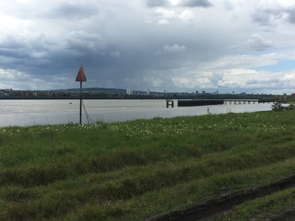
The path ended where another jetty cut across the riverfront, and we were forced to turn inland at the Barking Riverside Visitor Centre. This sustainable and temporary facility built from whitewashed shipping containers attempted to sell the concept of the new urban area from the very centre of the empty space it would one day occupy. An active and malleable imagination was required to see the dream today. We took the opportunity to rest around the gravelled courtyard, or to use the toilet facilities. While we waited to regroup, mostly looking silently across the river to Crossness and beyond, the storm which had rolled over South London finally broke upon the river. A squall of wind heralded a steady and hard rain. I unfurled my coat and deployed the hood for the first time, feeling justified as I waited for the rest of the group to gather and leave this exposed spot. I was rather sad to turn away from the river, having spent so much time trying to find a way to reach this area and wondering if it would be even remotely the same should I return? A gravel drive took us inland, towards the huge pale blue shed which had formed part of Barking Power Station. These last remnants of the three stations which have existed around this spot over the last century or so disgorged cables in all directions leading to clumps of transmission equipment and ranks of pylons. The idea of living among this is challenging - and it will be interesting to see how the blending of this essential infrastructure - not all of which can be easily removed - and a modern suburb will be achieved. We turned west, following River Road through the remainder of the site occupied by the former A and B power stations, including the building which heads the cable tunnel carrying power beneath the river to South London. Some of the buildings, especially the more ornate brick structures from the original 1897 station, will remain in new use - but much has already been swept away, with pristine new roads appearing on the empty site. Behind a high wire fence, bus lanes await services which have not yet been commissioned, and a new school is marooned in the midst of the empty site. Housing is springing up, but it is ill-served by transport and retail just now, and there is just the sense that Riverside will suffer the same drawn-out and painful genesis as Thamesmead or Bradley Stoke in Bristol. Making new places from scratch is always going to be a race of population versus infrastructure, and it almost impossible to imagine the right balance. I'm not sure it's quite right here at Barking, but it's equally not hitting the mark back on City Island. These are strange times to be building suburbs.
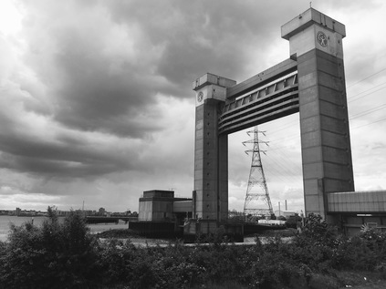
Our walk was almost at an end, and as the ominous towers of the Barking Barrier leered over the industrial units which occupied the site of the thankfully long closed guano works, we left a new place and entered a deleted zone. Creekmouth village once edged up to the banks of the river here, where the Roding and Thames meet. The villagers were supported by a range of fairly horrible work, not least skimming fat from the sewage which washed up on the beach for future use. The terrace of homes housed a small, tight village community that had its origins in the days of the Barking fishing fleet and the ice houses which allowed the boats to head further out into the North Sea, returning with still fresh fish. Creekmouth survived despite the odds, a tiny and isolated community with its own school, post office and pub, but little else. Decline began for the village in 1953 when the great North Sea flood which swept up the Thames caused untold damage to the homes. While people moved back, defiant and uncowed by the waters, the place was never the same. Families began to drift away, and now there's little to see of Creekmouth save for the Crooked Billet pub - now a premier venue for Romanian weddings - and the old school building. Around them is decay, filth and dust - the business of Dagenham moving west to occupy the unwanted land at the meeting of the rivers. We walked out to the barrier, quiet and wind-buffeted as it was on my last visit. In 1878, when the Princess Alice sank off Tripcock Ness after colliding with the Bywell Castle, many of the 650 victims were washed up on the water's edge here at Creekmouth in the following weeks, and it's hard to imagine the horror this tiny community must have suffered as a result of a tide of sewage-bloated bodies at its feet. And so, at this somewhat mournful spot where two rivers met and unimaginable suffering had occurred, our party began to disband - most of us making the walk up to the bus stop to head back to Barking. It had been a surprising and varied walk, with Rob as an excellent guide as before, and while some of the issues of accessing Dagenham's industrial zones had been demystified, there was so much to go back and research now. Perhaps it was possible to get to some of the areas I'd deemed entirely off limits after all?
As I waited for the newly-rechristened EL3 service, the rain began to fall again, steadily soaking the dusty wet pavement and kicking up a loamy petrichor to replace the stink of rotting refuse. It always seems to rain when I'm leaving Creekmouth...
A gallery of images from the Blackwall to West Ham part of the walk is here, while photographs from Dagenham and Barking are here.
Lost::MikeGTN
I've had a home on the web for more years than I care to remember, and a few kind souls persuade me it's worth persisting with keeping it updated. This current incarnation of the site is centred around the blog posts which began back in 1999 as 'the daylog' and continued through my travels and tribulations during the following years.
I don't get out and about nearly as much these days, but I do try to record significant events and trips for posterity. You may also have arrived here by following the trail to my former music blog Songs Heard On Fast Trains. That content is preserved here too.
