Out of the Voracious Sump: Walking back from Essex
Posted in London on Saturday 3rd February 2018 at 11:02pm
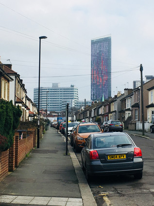
A steady rain was falling on the shining pavements of Upminster. Not heavy enough to make me pause in my plans for the day, but equally showing no sign of relenting any time soon. The trip out here from the city had been convoluted, but had passed surprisingly quickly and without any major disruption, and I was setting out a little sooner than I'd expected into the damp town centre. I'd never been to Upminster before. I'd certainly passed through: on trains scudding out to the coast, or on long meandering walks along the nearby Ingrebourne River - but I had little preconception of what I'd find at the top of the station steps. Somewhat unexpectedly, Upminster had the air of a prosperous small town. A smattering of the right kind of stores peppered the parades of interwar red-brick suburban shop-fronts flanking the street, breaking up the usual aromatic mix of takeaways and hair salons which are never far from a station. I was heading for the crossroads at the centre of Upminster where the A124 begins its journey into London from this almost-Essex town turned dormitory suburb. The ancient centre of a village with a long, distinguished history of being on the edge of a relentlessly growing London, Upminster was dragged - administratively at least - into its gravity in 1965. But the place still feels, and to some extent looks, like a market town in rural southern Essex. Squeezed by the statutory girdle of the Metropolitan Green Belt to the north and south, it edges out towards the M25 and even breaks the membrane to stray a little beyond. The District Line quits at Upminster having reached here in 1902, while the parallel tracks of the London, Tilbury & Southend Railway are left to continue the journey east. In fact, the District Line tracks struggle on for a further mile or so beyond the station into the vast depot at Cranham, near where the majority of the TfL-commissioned red buses also give up and turn back west. Upminster grew dramatically after the coming of the railways, blossoming again between the wars to become the de-facto district centre for the sprawl of new residential suburbs here at the edge of Greater London. As such it has perhaps never been well to do in the strictest sense, but today at least it certainly felt like it was doing well enough among the liminal uncertainties of 2018. I passed numerous well-dressed young folk heading for the station, drawn in by the train into 'town', though there were perhaps surprisingly few non-white faces peering down at the screens of 'phones and tablets. This is another boundary - a distinct zone where London's legendary diversity peters out entirely. Upminster didn't appear to suffer the bitterly proud, BREXIT-stoked racism of Dagenham or the knife-edge tolerance of Barking's complex population mix. Here it was just olde-England's shire-county conservatism accidentally straying into the edges of the city. I surveyed the corner up ahead with some trepidation. To the east was Essex - and Waitrose of course - but to the west was the massive, brooding imposition of London. A huge gravitational drag along the busy A124, an old road which has wound in from Essex for hundreds of years. Today I was using it as the pretext for a walk in from the edges. A return to the east which felt long overdue. If I started walking, I knew I'd feel the sense of another project underway. I recalled Jonathan Meades closing remarks in The Joy of Essex about the county's ability to consume and reclaim, not least referring to the absorption of whatever London cast out, and wondered quite where this walk would take me?
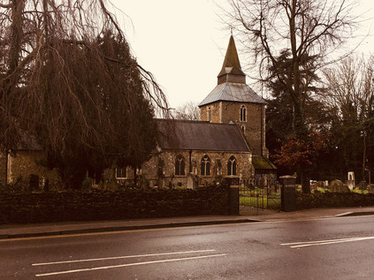
To the south of the crossroads, the squat tower of St. Laurence's Church loomed over the highway looking every inch the rural parish church despite the presence of a busy branch of Lidl nearby. From the tower of St. Laurence in 1709 the Reverend William Derham made remarkably accurate measurements of the speed of sound by way of a telescope and the flash of a distant gunshot, timing the report with a half-second metronome. These scientific pursuits seem a strange kind of work for a country parson, but it seems he was perhaps no ordinary cleric. Derham's written work fuses his theological and philosophical arguments with a surprisingly open and naturalistic mind, describing nebulae, natural variation in species and distant star clusters in his effort to forge a tangible Physico-theology. Resting near Derham in the churchyard, and like him with no memorial is Alice Perrers, mistress of King Edward III - a popular monarch in his time who seemed to fall out of favour with modern historians for not foreseeing the part his legacies would play in dividing York and Lancaster after his passing. The fact that he took no mistress until his consort, Philippa of Hainault, was terminally ill displays rare royal restraint for the period. The quiet of Derham and Perrers' repose was challenged by the steady westward stream of traffic which fussed and boiled to navigate around the regular procession of buses starting their journey back towards Romford. As I passed by, an older lady tripped and fell at the bus stop outside the church with the sickeningly specific sound of a crumpling body hitting concrete. A car screeched to a halt and someone was soon helping her back to the seat. She patted the helper away, protesting that she was fine and had just slipped. It was hard to tell if the dusty but otherwise seemingly unharmed woman or her good samaritan was more embarrassed by this un-British display of kindness - but it made clear that I was not in London. Somewhere between here and the city the tone changed and any unusual happening or public mishap was a non-interactive spectacle, a situation worthy of recording but not of intervention. Uncomfortably, I realised I'd just done the same - and so I moved on.
While the sprawl of suburbia along the A124 meant that little of the substantial swathe of greenbelt surrounding Upminster reached the margins of the road, there were still distinct divisions between the former towns and hamlets which straggled along the road. As I left Upminster, passing the windmill which has remarkably survived since 1803 but is currently shrouded in white for repairs, I began to descend into the valley of the Ingrebourne. I had briefly passed this way before, emerging from the farmland to the north to pass under the railway and head south towards the Thames. This time I was crossing the territory from east to west, and thus I was far more aware of the deep groove carved over the millennia by this apparently modest little river. The bridge here was first recorded in 1375, and the current brick bridge is at least the fourth on the site, dating from 1892 and once complete with cast iron sidings from the Whitechapel Bell Foundry. At times a ford supplemented the bridge, such was the importance of the route. But now the crossing was easily missed, with most assuming that the nearby Upminster Bridge station on its high brick viaduct was the origin of the area's name. Remembering the short strip of shops here I popped in to stock up for my walk, and emerged to find the rain slowing somewhat. Encouraged, I struck off westwards again, crossing Hacton Lane - which formerly led to the now almost entirely absent hamlet of the same name. At the crest of the hill the tall verdigris-covered spire of St. Andrew Hornchurch announced my crossing into a new parish. At the eastern end of the building, a stone bull's head pointed its horns back east - an 18th century addition, with the name of the area long-predating this somewhat literal interpretation. Despite the presence of the usual range of High Street ubiquity, there was a sense of something ancient about Hornchurch. The mock Tudor villas which had stretched along the road behind their well-kept but traffic-battered gardens petered out a little outside of town. Their faux-historical take on the old vernacular was overshadowed somewhat by the presence of the genuinely venerable, haphazard tumble of the Kings Head - now occupied by Prezzo who have shown remarkable restraint in preserving the building's dignity. But Hornchurch offers a rather more distant link to pre-history, being the most southerly point in Britain which sheet ice reached during the last ice age some 450000 years ago. The ancient geology is reportedly best seen in the railway cutting which carries the rather quiet Overground shuttle service from Upminster to Romford, where layers of geological detritus carried from the Midlands by the advancing ice can be found above the native Essex clay. The town centre of Hornchurch bustled and rushed, apparently unaware of its historical importance, centred on a knot of roads linking the suburbs to the north and south. I paused for coffee here, watching the comings and goings of the locals. Perhaps more than Upminster, this felt like a place distinct from the surrounding city and suburbs - a busy town which could perhaps be anywhere in England. That said, it was clear that the area owed much of its prosperity to the gravitational pull of London, with a steady stream of pedestrians headed briskly south towards the station as I looked out over town. If Hornchurch had been plucked up and deposited in the Midlands by some trick of the retreating ice, it would no doubt have struggled to survive.
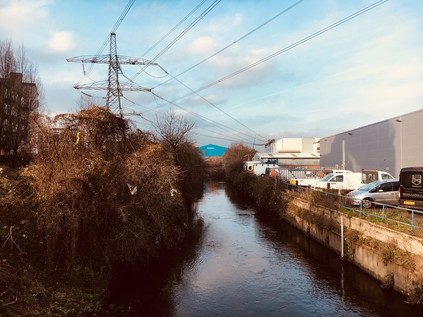
Underway again, the road took me briefly into green space at last, dipping to cross the tiny Ravensbourne near Abbs Cross Lane. This brook hadn't featured in my previous walks - largely because much of it runs through the back gardens of suburban homes and other inaccessible places, meaning little of its relatively short length is walkable until it reaches the lake in Harrow Lodge Park near its confluence with The Beam. The road here was busy with speeding traffic navigating the curve and rising away from me in a cloud of spray and fumes. I paused in the steady drizzle to snap a picture of the tiny watercourse hemmed into a weed-choked concrete channel under the road, and incurred the interest and apparent displeasure of a passing local laden with Sainsbury's bags. He passed me, tutting and muttering although I posed no obstacle to him, then frequently looked back, suspicious of my motives in photographing the stream. As I made the steady climb away from the Ravensbourne, the rain began to fall more steadily. I was already soaked through and decided not to let it bother me. The road plunged into dreary and damp suburbia again - a long stretch of housing filling the spaces between the old towns of Essex which had once been prime farmland. I trudged on, wondering if this walk was just too contrived and obscure to really have a focus? How could I connect these disconnected blips of population which huddled along the District Line for safety? It was easy to feel discouraged in the gloom and damp, the only diversion arising from the need to move deftly to avoid being splashed by passing vehicles. Few people were around, and faces gazed at me from warm, comfortable cars in disbelief. Why would he walk out here? No-one walked out here.
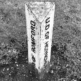
And so I found myself back in Romford. My route skirted the southern edge of the town, passing the site of the former Roneo works, now a vast retail development which nestled into the corner where the main roads met the Beam River where it emerges from its largely unremarked passage under the Town Centre. The area around the former works site is a confusion of closed cafés and repurposed shops now doubling as offices and builders' merchants. It's clear that the departure of the factory, a huge employer locally, had left this outlying corner of Romford beleaguered and purposelses. The river plunged underground again to negotiate the busy junction with the A125, though its disappointing trickle could be seen in a deep concrete trough curving north alongside the road through the grounds of the vast new Queen's Hospital. South of the junction, the stocky and purposeful tower of YMCA's Thames Gateway building loomed over the otherwise flat landscape of the Beam Valley. My last passage through this area, when walking along the river, had been on a brighter spring day when a swift crossing of the road had soon seen me back in the relatively rural edgelands of Grenfell Park. Today though, my route lay to the west. As I headed away from Roneo Corner I spotted an old boundary marker driven into the ground dividing the former Urban Districts of Hornchurch and Romford. Much had changed on the ground since these divisions were laid down along the routes of ancient roads and rivers, and it was strangely cheering to see this vestige of the past persisting among the churn and change which surrounded it. With much of the traffic barrelling away towards the centre of Romford and onto faster routes into London, the road became something of a suburban backwater here: a long avenue stretching west through Rush Green, with ranks of dustbins and bare trees stretching into the middle-distance. The rain was falling steadily now from a swirl of grey cloud which showed little sign of moving on. This felt, perhaps unfairly, like a grim spot - a route which connects nothing with nothing. Persisting despite the gloom which seemed to descend as I walked further, I soon found myself passing the gates of West Ham United's training ground and beyond it the park where the Wantz Stream had been dammed to form a boating lake. There is little above-ground evidence of this once surprisingly long stream aside from its much truncated ramble through scrubby parkland to meet the Beam, so this hint of its former presence was welcome. The former crossing beneath the road was also evident from a low railing on the southern side, which once featured a coloured plaque bearing the arms of Essex. Beyond the fence a tangle of wild grasses and bushes described a narrow backfilled channel between the houses of Rush Green Road and the low-rise flats of Widsons Close. The culverted stream had been co-opted as additional garden space, and was cluttered with tumbling sheds and tarpaulin covered cars. Approximately at the point where the river would have passed beneath the road stood large signs welcoming me to Barking and Dagenham, with the squat remains of another Coal Duty Post nearby. The Wantz Stream still performed a civic duty in providing this boundary, long after its more prosaic work was consigned to the underworld. I crossed the hidden river, wondering what life would be like on this side of the intangible divide?
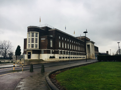
My first impressions of entering the Barking and Dagenham from this new angle were not positive. Wood Lane was a litter strewn and windy chasm leading west, away from Central Park. The development of this area had been carefully planned, but the expected approach was very much from the west. Therefore I first encountered the imposing modernist hulk of Barking and Dagenham's Civic Centre via the less impressive northern shoulder - a rank of white-painted stone window mullions dividing the slab of brick and Portland stone, relieved by a curved glass stairwell on the flank. It was a solid, clean-lined and functional building which looked surprisingly elegant from an advantageous angle, set in a wide and open area which placed it in odd isolation. A chill wind whipped in from the Thames, swirling litter and builder's dust around the grass and flowerbeds which narrowed into a roundabout up ahead. The building was conceived by architect E. Berry Webber as a statement entrance to the nearby Becontree Estate and was ready for use by 1937, roughly contemporary with the completion of the main phases of housing. Webber went on to propose similar plans for Hammersmith's Town Hall very soon after work here was done - but his plans there have been greatly modified by unsympathetic extensions and curtailed by the building of the Great West Road. By contrast, Dagenham's Civic Centre stands now looking largely as it had since opening, despite some less elegant but not overly intrusive 1960s additions. It also appears from the strength of feeling when austerity threatened its continued use, to be a much loved local landmark. On that basis, I was curious what the locals thought of its recent reincarnation as an outpost of Coventry University? Provincial educational establishments gaining a foothold in the capital appears to be very much the done thing now, but taking over a popular local landmark is a bold and ostentatious move. Pondering this land-grab, my route now led away from the Civic Centre, giving unexpected views back across the building and its approaches, which from this vantage bore an unlikely resemblance to a North American High School. The views ahead were decidedly British however as I trudged by the bulky, drab tower of Laburnum House and into the edges of Becontree. This vast estate was developed between 1921 and 1926 on compulsorily purchased former market gardening land, in order to rehouse families from cleared slums as part of a post-war drive to provide homes fit for heroes. Wood Lane, an ancient route which turned south at Becontree Heath, still describes an arc around the bounds of the original development of nearly 24,000 homes which was extended twice before finally reaching nearly 27,000 dwellings by its final completion in 1951. The estate has, at various times, vied for the prize of being the biggest development of housing in Western Europe. Despite the sheer size of Becontree, there is much to recommend about the homes here - solid, mid-century municipal designs which have lasted well, and which are arranged around a reasonable quota of green space. The first tenants of Becontree moved into an isolated, muddy morass with no extant services and a temporary railway running along the future route of Valence Avenue to bring materials to the building sites. Later though, the estate prospered in part due to its proximity to the Ford Works and the belt of industry along the Thames. Initial tenants were carefully screened for suitability by the London County Council, with their standards of hygiene and continued employment a key factor in securing one of these modern dwellings. While the Housing Act of 1919 permitted the LCC to develop these areas and act as landlord despite it being outside their turf, the administrative position around the estate and its cleansing and services remained complex until Local Government Reorganisation unified responsibilities for the site in 1965. Prior to that, various parts of the land fell into the districts of Ilford, Barking and Dagenham with the attendant confusion around schools and services requiring a range of exceptions and easements. While many homes here had long since been purchased under the right to buy rules, there was still a sense of being on a vast estate, and as I deviated from Wood Lane into the midst of Becontree, I was struck by the uneasy feeling of being somewhere which felt very familiar from my own upbringing in the Midlands. The long, straight boulevards of Valence Avenue and Becontree Avenue crossed at the midst of a cluster of local shops which were a little tired and typical, but which were still pleasantly busy. Becontree appeared to be soldiering on through these difficult first months of the year - a little tired, a little wet - but still here.
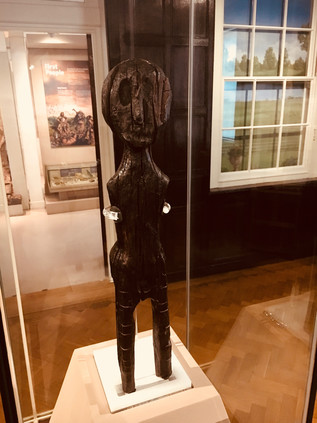
In the midst of Becontree though is a remarkable survival of all this civic and social change. Valence House was first recorded on this site in 1269 as one of the five ancient manors of Dagenham, with the current building noted as standing from around 1400. In 1921 the house, complete with a moat, was still serving as a family home - before being used by the LCC as its local headquarters during the building of Becontree Estate. Between 1928 and 1937 the house served as Dagenham's town hall until the Civic Centre was ready for business at which point the Libraries Department took on the building. The house is now a local history museum, sitting at the north-western corner of the busy park with a small remnant of its moat still separating it from the car park. I skirted the impressive new visitor centre, complete with a sculpture of a rusting Ford Capri marking Dagenham's link with this ubiquitous example of 1970s style, and headed directly for the house. I'd finally come to see something which I'd read about and had been curious to find for some time - The Dagenham Idol. Pulled from the marshes when sewers were being laid along Ripple Road in 1922, the idol is an eighteen inch tall human figure carved from Scots Pine. It was found by workers near the site which was to become Ford's sprawling riverside works, buried next to the skeleton of a deer which was possibly part of the same offering. Carbon-dated to around 2250BCE, the statue pre-dates the construction of Stonehenge and lay undisturbed in a preservative layer of peat awaiting its twentieth-century rebirth. While the rest of the displays at Valence House appeared interesting, especially those about the development and domestic arrangements of the building over the years, I was desperate to see the Idol for myself. After a show of the correct hands-behind-the-back-and-looking-up museum protocol on entering the quiet parlour I turned to the east and found myself looking history directly into its oddly oversized eye-socket. The idol is housed in a glass case in the centre of a panelled area which would once have been one of the fine reception rooms of the house. It gazes perpetually across to the west, eyeing the development of the great city of which its owner may possibly have been a founder. I circled the statue, enchanted by its great age but strange familiarity. It felt curiously appropriate that it had been brought here from its long, solitary home in the marshes into the midst of what had become this vast estate with its apparently unparalleled press of humanity. Would Becontree survive as long as the Idol? It was difficult not to superstitiously link their fates. The idol had reversed Meade's premise and made it out of the "voracious sump" after all.
It was hard to leave the quiet precincts of Valence House and the warm and inviting cafe at the visitors centre, but I needed to make progress and I was aware that the rain seemed to be slowing me down. I left the park and crossed the centre of the estate, aiming for Bennett's Castle Lane - mostly because it described an organic, twisting path on the map through the more regular geometries of Becontree, betraying its pre-estate origins. The lane is marked on early maps of the area, curving roughly southwards towards Longbridge Road - the continuation of the A124 from Wood Lane. The origins of the name are obscure - though on the 1894 revision of the Ordnance Survey map there is both a Bennett's Castle House east of the road near Valence House, and a separate Bennett's Castle nestled into the junction with Longbridge Road. There are no specific records of any sort of fortification - though if the name weren't clearly much older it would be tempting to link it to local industry via Henry Ford's notorious security chief who built a fortified 'castle' in Ypsilanti, Michigan. The lane also marked the boundary between Ilford and Dagenham, a fact blurred by the development of Becontree and erased by the redrawing of Borough boundaries in 1965. Now, Bennett's Castle Lane winds its way towards the edge of the estate in unremarkable style, arriving at the corner which appeared once to have provided its name with little ceremony. I was back on the A124 as it once again became a surprisingly quiet avenue.
Longbridge Road takes its name from a crossing of the little Mayes Brook which, if old maps are to be believed, was well-named. The road appears to run directly above a long, broadened stretch of the water before they part, with the brook heading south towards the Thames. I'd been here before - on a bright winter morning tracing the now largely hidden path of the brook through the urban developments which have filled the once open countryside. The busy curve of road where Longbridge would have crossed the brook is now a difficult to navigate junction beside the Parkside Community Centre. My progress across the street was watched with interest by a small group of locals sheltering and smoking in the lee of the centre like ceremonial guardians for the long-deleted bridge. The brook rose again south of the road in Mayesbrook Park, but my route continued to take me west, passing long, rather fine looking blocks of municipal housing set back from the road. This area appeared to have been developed in the 1930s, with Faircross - where the road south to Upney intersected my route - developing from a tiny hamlet into a busy local shopping area. The walk here was tough going - I was thoroughly soaked now, and the route into Barking seemed endless and unrelenting. I finally arrived at the huge roundabout marking the fringe of the town centre where a modern bypass takes much of the traffic which once passed through the centre of Barking in a northern arc. At the midst of the roundabout was one of the few notable pieces of public art in the district - The Catch - two delicate, silvery metal fishes leaping from the ground in celebration of the historic local fishing fleet, long since decamped to the North Sea. As I crossed the complicated pedestrian route to reach the town centre, I was accosted by perhaps the least successful beggar I've ever encountered. "Gimme one pound cash brother!" he exclaimed, and I turned to see a gentle-featured but huge black man towering over me, his palm extended hopefully. I genuinely had no cash and told him so, but he trailed silently along behind me his shoes flapping at the pavements. From a little way behind me as I paused at a crossing I heard "Gimme one pound cash sister!" - and suddenly the woman whose loud cackling into her mobile 'phone I'd been studiously ignoring turned on him: "Get a fuckin' job, I don't earn money to give it to you, how fuckin' dare you ask me for money. Go to the job centre! Fool!". He didn't seem to find the outburst surprising and padded off along a side-street, lured in by a promising looking crowd hovering outside a takeaway. She strutted away towards town, loudly complaining into her 'phone that anyone would have had the audacity to ask her for money. She held the device away from her face, yelling her disdain into the void between her and the microphone. I slowed my pace, wanting to let her disappear into the busy crowds of Station Parade so I could forget how her twisted, angry mouth had looked as she'd spat her words at the clearly vulnerable and compromised man.
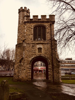
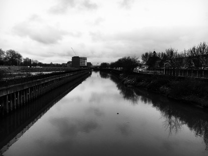
There was a time that Barking was just another stop on the railway for me - a point where routes converged and carefully planned changes between lines were possible. In recent years though, it has become a repeatedly visited nexus on my walks: a crossing point on my journey around the North Circular and a staging post on my walks along the A13 and the River Roding. The Town Centre in particular is all too familiar - a busy, edgy churn of buses and people. Today I passed directly through the centre, finding dodging through a crowd rather challenging after a day of almost solitary walking along damp, suburban avenues. Barking feels like a frontier town - where the attitude and frustration of London crashes onto the calmer shores of Essex. Beyond here, as I'd seen, there were distinct towns and communities, but Barking has been almost completely absorbed by the city - and thus shares in its benefits but shoulders a perhaps unjust burden of its misfortunes. The town is a vestige of a mid-century redevelopment, the busy open-air market wedged into a broad pedestrianised zone between budget chainstores and mobile 'phone shops where it can take forever to make a simple enquiry. The service is low-energy, relaxed to the point of glaciation. Try to hurry things along and they'll move even slower, suspicious of your eagerness to get out into town. The shops are artificially heated sweatboxes which reek of desperation for credit and status. By contrast, business at the outdoor market clips along at a furious pace - bags are spun deftly between fingers to close them, change is drawn swiftly from oily cloth pouches. The discourse is abbreviated: newly arrived accents slipping into the oldest forms of patter without effort. I struck out across the centre of town and wasn't sorry to reach the western edge, where the ancient remains of the abbey stretch along the banks of the river. I paused under the Curfew Tower, the gateway to the Abbey precincts from which a bell would call citizens to douse their fires or suffer penalty as directed by William of Normandy. A 12th century stone representation of the crucifixion is kept in the tower, an object of pilgrimage and a remarkable survival of the destruction of the abbey in 1540. Beyond the tower, St. Margaret's Church remains a place of worship amid its mossy graves and damp churchyard beside the river. I crossed the Abbey grounds, heading for the bridge over the Roding which flowed sluggishly beneath, waters swollen from the rain and tide. The ever-present aroma of mud and sewage drifted along the river as I looked south over paths I'd walked before. Beside the river, the ramps up to the North Circular shuddered and clanked under the weight of traffic leaving Barking under the gaze of another artistic sentinal - Joost van Santen's 'Lighted Lady'. This asymmetrically twisted column of acrylic and light which changes and shifts in colour marks the entrance and exit point of the town, and for me the beginning of the final part of my trek - out of the east and into the 'East End' of legend and tradition.
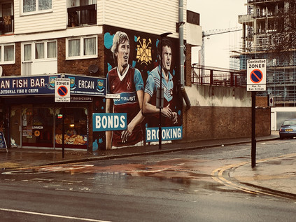
I zig-zagged under the concrete of the flyover and out of Barking, having passed the twin barriers of river and road which separated it from London. From here on, the streets conformed to a victorian pattern of long terraces leading away from the straight road into town. In some ways, this section of my route belonged to my A13 project as the former route of the road had taken this path through East Ham and Canning Town. I realised with some surprise that I was on familiar territory - if from an unusual angle. To the south, Langdon's Academy sprawled along the North Circular - and I recalled striking out along a path edging around it on a previous walk. Meanwhile to the north, the inaccessible scrubland which had barred my way when tracking the Roding south ended in a tangle of unkempt trees and rampant flytipping. I was also crossing into the London Borough of Newham here - one of the proud host boroughs of the 2012 Olympics which seems to be none the richer for its tolerance and hospitality. The road soon gave way to the rows of terraced side streets, named in the Victorian style and with considerable imperial glee for generals, battles and saints. Barking Road was a long-established thoroughfare, no less busy for the building of the new A13 to the south, as it provided access to this vast hinterland of residential streets which marched into the city. I passed the impressive red-brick clock tower of East Ham Town Hall, currently swathed in cloth for repairs but still a landmark on the route into town. Newham Council decamped in 2009 to an anonymous glass hangar on the edge of the Royal Docks in a move which showed a good deal of disdain for the local population which has historically clustered around this area. However, there was a more significant hollow at the heart of this community - a gaping absence where the Boleyn Ground had once stood proudly among the homes and shops. My last interest in football, save for a few notable World Cup tournaments which piqued my curiosity, was on 8th March 1980 when Aston Villa's FA Cup run was cruelly ended in the quarter final by West Ham United. Having listened on the radio in growing disbelief, I remember my hot, perhaps rather spoilt, childish tears of frustration and rage, and a vow not to let this game get me so upset again. I was always an oversensitive soul it seems, but passing a mural of Billy Bonds and Trevor Brooking, I began to understand how this pursuit and the ground which provided a focal point for it had defined this street. With the stands sitting proudly in the midst of this teeming neighbourhood, everything hinged on West Ham - and while it was no doubt the livelihood of many of the local shopkeepers of Barking Road, it was likely the scourge of plenty of locals who wanted a quiet life. The team's ill-fated departure to the Olympic Stadium a year or so back hadn't solved any of these issues and had created plenty more. I vividly remember being evacuated from Stratford on the afternoon of the first match at the rechristened London Stadium - we had strayed in from the industrial hinterlands on a wander around the east, and were swiftly and unceremoniously guided out of the emergency doors and into the Carpenters Estate as a helicopter circled above. The crowds of shoppers dawdling around Westfield were apparently not compatible with a single-minded surge of football fans heading for the hostelries pre-game. On Barking Road, the long parade of shops - the pristinely clean Nathan's Pies and Eels and the Ercan Fish Bar complete with mock West Ham crests - masked the site of the ground, a forest of cranes marking the regeneration efforts. The shops were quiet, pedestrian traffic almost absent. I sloshed along the forlorn street wondering what would become of the businesses here, their ambivalent blessing and curse now gone for good. Would the heritage fetish bring fans back here to their true home, or was it all too late? At the next corner, a statue proudly depicted a cross-section of the 1966 World Cup winning squad, a group of West Ham players who had provided an ongoing engine of national pride which was still recalled in keycodes and passwords generations later - 1066 and 1966 - our defining moments, almost a millennium apart.
I passed into more familiar territory as I crossed The Greenway, that elusive and strange footpath running along the Northern Outfall Sewer which became something of an unattainable prize during the post-Olympic years when re-opening was often promised but never delivered. At its crossing of Barking Road it is running at ground level, usually with long views both east towards the Barking Flood Barrier and west towards the new towers of Stratford City. Today though, there was a flat grey wall of cloud blocking both views. People emerged from the gloom, trudging along the wet path with their heads down. It was good to see the path busy and used though - this stretch in particular had always seemed like a much missed amenity at times when it was off-limits. It was tempting to swing north and west, to head for familiar old landmarks - but I'd decided to press on into Canning Town to complete the sense of entering the city proper, so I pushed on despite my feet aching from walking on slippery pavements all day. Beyond the Greenway, the ribbon of retail units begins which run for the remainder of the length of Barking Road to an abrupt ending where East India Dock Road leaps over Bow Creek. In the distance I could see the cluster of shadowy towers emerging from the gloom on the Isle of Dogs. The road into Canning Town was in transition - and probably had been for years, likely since the closure of the docks. The resolutely homogenous crowds back in Upminster seemed a world away here where old Indian men shuffled along beside swaggering young men with low-slung trousers and Eastern European women pushing prams slowly along the pavements. A shard of red and black glass pierced the gloom - one of the towers which had emerged from the redevelopment of Rathbone Market. Anyone you asked would tell you it was no good - that the old Ratty had been destroyed by the new buildings and the character and charm was all gone - but the community here had been shifting and changing for much longer. The market they missed was in truth the ghost of the one that had been buried long ago, and the spirit of place which is now much closer to the surface in the satellite towns I'd walked in from. As I joined a bus queue which silently shuffled towards a parade of double-deckers emerging from the darkened eastern skies, I considered the area where I'd finally stopped. This spot united many of my excursions and felt almost homelike in its familiarity. I could navigate from here to almost anywhere in the complex network of rivers and roads which I'd memorised accidentally by a seemingly random pattern of walking and re-walking over the years. This spot marked the end of an unremarkable dark ribbon of asphalt snaking in from the edge of things which had wound a steady course through former towns with roots in prehistory, precious unburied idols and the keen absence of more recently diminished heritage. In the growing gloom of the afternoon I boarded a bus to Aldgate, reversing my incomplete walk out of London to the coast which had begun a long time ago, and crossing the boundary of old Essex as I crossed the River Lea. It had been good to be back out east at last.
You can see more pictures from the walk here.
Ill-treated and still hardworking: Walking The River Wandle
Posted in London on Saturday 13th January 2018 at 10:01pm
The turn of a year always generates reflection - and as I sped towards London on an unusual mid-month trip, I realised I'd not slept nearly enough. I was troubled by both physical and mental disquiet, suspecting I'd picked up some sort of minor virus to accompany a strange and unshakeable anxiety that had stalked me into the new year. I was restless to get underway yet simultaneously prematurely fatigued and it was easy, in these conditions, to begin question why I undertake these treks across London, and even if perhaps I should just cut my losses and stop? Too often, when challenged, I cleave quickly to the charge of pointlessness. I wonder if I'm perhaps trying to write myself into the shoes of thinkers and authors I admire, or to moderate others' experiences through my own strange schemes and invalid contrivances - but then I think it's far, far simpler than that. I realise, as my memories of childhood start to idealise a time of stability and simplicity, that I want to turn the map into the territory: the years of solitary wonderment at the pages of the A-Z, the drawing and redrawing of optimal routes across terrain I could barely even imagine. I've needed to be able to make these walks for many, many years. Why London when it's not 'my' city? Because it is no-one's city - and therefore eternally up-for-grabs. A tangled, dark mass that feels unknowable, but of which millions can picture their tiny corner in minute, local detail. A city where one can still discover things afresh and stumble into novelty unexpectedly, but also where thousands of years worth of sometimes dubious clues to the undocumented treasures have been laid by prior travellers. As I step off the train at Paddington and start a zig-zagging bus and rail journey south towards Croydon, I resolve to keep walking at all costs whether anyone is reading or not...
Curiously, a former colleague had been in touch during the week as I'd planned this walk - he sought an introduction to someone who could help him with a project he was beginning at the London Borough of Croydon. The footer of his email dispensed with the legalities and declared simply CROYDON in bold font, mimicking the Mayor of London's own block capital strapline. However, I stepped out of West Croydon station into a decidedly lower-case tangle of unruly buildings running along the edge of the railway. In particular, a glowering, red-brick Victorian shopfront faced me from across the street and channelled me towards a crossroads where the more salubrious shopping areas began. I hadn't strayed into Croydon in years - and when I was last here it was a fleeting visit to cover the new tramlines. The reality of Croydon was both more interesting and much more confusing than it had appeared from the windows of a tram - a modern city centre imposed on an overgrown suburb as a mid-century modernist project, with the second generation of new glass towers already striking against the dull January skies. A forest of cranes signalled the ever-present redevelopment, while my route west lay between terraces that could comfortably have been resettled in Nottingham or Edgbaston. The town was divided by Roman Way - a sweep of dual carriageway elevated to clear the railway and tramlines heading west from the centre and named for the disputed presence of the ancient route between London and the coast. Assumed to branch from Stane Street at Kennington and ploughing south through the Caterham Gap to cross the Low Weald, the existence of the road is based on fragmentary evidence - pieced together tracks, flint beds robbed for turnpike surfacing, and Anglo Saxon street-nomenclature along the way. It is comforting to feel anchored into the past though, as Croydon had an indistinct and impermanent feeling this morning. From the rapid cycle of demolition and rebuilding in the centre to the futureless and stateless people awaiting their fate at Lunar House, the nearby Immigration Compliance and Enforcement office, nothing felt like it was permitted to contemplate its future here yet. Croydon floated uneasily over the headwaters of the River Wandle. In the much-misused gazetteer of the Royal Mail's postcode directory, the centre of most major towns and cities is always 1 - the primary zone. In Croydon, it is an absence - CR0. Ground zero for both the river and the city was the same patch of boggy marshland. As I shuffled under the main road and headed for the water, I noted the road was appropriately named 'Pitlake'...
A short tramp through the suburban backstreets of Croydon brought me to the first of several Wandle Parks I'd visit today. Formerly two marshy fields - Froggs Mead and Stubbs Mead - the area was drained and established as a public facility in 1890. The River Wandle makes its first public appearance here nowadays. Despite being culverted in 1967 due to regular drying-up and appalling water quality, environmental improvements in that heady project-obsessed Olympic summer of 2012 saw the river uncovered and allowed to wander across the southwestern corner of the park as an enhanced public amenity. The stream begins to gather strength under the streets of Croydon, where seasonal streams or winterbournes from Caterham and Coulsdon merge to form a sizeable, relatively clean flow through the park, before disappearing again under New South Quarter, a surprisingly decent but depressingly predictably named development of new homes which hugged the course of the river with excellent access to the nearby Tramlink stop. Having crossed the tramlines I was forced to navigate the crescents of the development, feeling ill-at-ease in the domestic business of the obviously private zone but equally pleased to see the river cleverly managed into the development. The Wandle curved reedily and silently in a deep channel which bisected the development, before disappearing from view again to pass under Purley Way and the run of vast retail sheds which are slowly reclaiming large zones of former industrial brownfield vacated by the vast Croydon Gasworks. As I passed by an apparently recently opened John Lewis at Home superstore I reflected on this area - once largely empty marshland, fed by the remarkably fickle waters which make up the Wandle - streams which rose and fell with the season, sometimes disappearing entirely and then returning as a fatal tumult when heavy rain fell. On the northern horizon two chimneys towered over the low-rise retail landscape, remnants of Croydon's municipal power station which fed the street lighting locally until surprisingly recently and utterly complicated its renewal. The tall stacks are marooned in an Ikea car park, surrounded by a newly laid pattern of streets which crackle with false memory: Volta and Ampere Way surround the store. They make a striking mark on the dull wintry sky - and there is always the temptation of strolling north for a picture - but I'm painfully aware of the risks the amateur explorer faces in lurking in Ikea car park. At best, arrest is possible - at worst, perhaps trespassing on a trademark?
At a rather gloomy crossroads I turned west again onto Mill Lane, one of many streets in the Wandle valley with a similar name, giving a hint to the nearly constant industrial uses of the river. By the late Victorian era, the waters turned the wheels at over ninety mills between Waddon and Wandsworth, many of which had existed from time immemorial. The Domesday Book mentions a flour mill at the northern end of Waddon Ponds which remained operational as late as the 1870s but which was finally demolished in 1928 and has apparently now been replaced by a strangely ornamental modernist multistorey car park marooned among the grimy, crumbling factories of an early 20th-century industrial estate of the type which fanned out along London's arterial roads. Access to the ponds was forbidden - further work was underway to make the green spaces around the river accessible here. A narrow path apparently once known as Brandybottle Hill climbed beside the line of trees which marked the edge of Waddon's backstreets, and soon the river was overground once again, flowing west into the exclave of Beddington Park which stretched east towards Croydon. I hedged my bets on walking the southern bank of the river here and soon found I'd possibly taken a wrong turning already, emerging on a narrow residential street simply called 'Bridle Path'. But as the rather quaint street wound north and west I was surprised to find myself walking alongside another brook which appeared on an older map to be the established line of the Wandle, divided here to power a Snuff Mill with an underground sluice still regulating the waters. The now more minor brook crossed under Hilliers Lane, emerging again into Beddington Park to rejoin the branch of the river which I'd lost track of a few streets before. Not for the last time today had the Wandle's indecision and bifurcation confused me. Walking in the park was quiet and pleasant, but my physical condition was taking its toll already. I slogged along the northbound path towards the Pavilion Café in the hope of a brief rest, but I found it already overspilling with the families of junior football players who were taking part in a Little League tournament nearby. I turned southwest instead, striking out across the wet grass of the open park towards a knot of trees indicating the course of the river. The huge expanse of green space here is a remnant of the Carew family estate - formerly a deer park with their home and the village church neatly squared away within acres of parkland which still has a curiously rural feel today. The house remains in the midst of the park, an impressive formal Tudor manor that now serves as a Special School. The Carew family finally left the area in 1859 after a turbulent few centuries which saw them fall in and out of favour with the royal court. In 1538 Thomas Cromwell seized the hall and lands from Nicholas Carew whose popularity had apparently begun to irritate the notoriously easily rankled Henry VIII. The family found more stable patronage under Queen Mary with their lands in Beddington restored to Francis Carew who perhaps advisedly took to carefully improving the gardens and lands around the hall rather than attempting to further make a name for his family at court. After the Carews departed the building became a 'Female Orphan Asylum' before slowly progressing towards its current purpose. Close to the house, the confusingly named Canon Bridge's Bridge spans the Wandle, a low red-brick decorative parapet memorialising the Rector of the nearby church from 1864-91. I regained the footpath in the hope of walking beside the lake in Grange Gardens where the Wandle broadens to form yet another former millpond - this time for a long-closed paper manufactory, but I was soon thwarted by more improvement works and found myself unceremoniously booted towards the main road a little north of the gastropub which now inhabits The Grange. After passing under Wallington Bridge the river disappeared between suburban back gardens, and I needed to decide where the head next...
By now I was realising that understanding the historical or geographic journey of the Wandle was far from a simple task and as I headed south again into the former village of Wallington, which now seemed to consist of little more than a permanent traffic bottleneck, I noted the shallow rise of land to the west which divided two branches of the headwaters of the river. The branch I'd followed from Croydon now turned north, but there was a western stream rising at Carshalton Ponds which lay a short climb away along Butter Hill. This stream is The Wrythe which gives its name to the tiny hamlet-like settlement which sits north of Carshalton, retaining curious isolation from its surroundings in no small part due to the natural boundary of the river. As I descend from the twisting course of Butter Hill to pass under a low railway viaduct the stream appears beside the road, a busily bubbling green-fringed channel which runs almost unseen towards the nature reserve at Wilderness Island where the branches of the Wandle finally meet. They tumble together at a weir that disappears under light industrial units built on the site of a former leather mill. Looking back across at the damp, green shore of the island, it seemed a miracle that it had survived so relatively unscathed among the industrial and residential developments which crowd around the Wandle - and perhaps more remarkable still that the river has remained above ground for much of its course to the Thames. The path emerged onto Hackbridge Road, the original site of this tiny village having apparently almost entirely succumbed to more of the drab industrial shacks which seemed to populate every spare corner of land around here. The centre of the village, such as it was, had packed up and moved northeast to meet the railway - my path was quiet and my walking uninterrupted. Except, that is for swarms of midges which by my reckoning shouldn't be out here in January. As I skirted the edge of Watercress Park - named for the naturally occurring crop which was harvested and indeed cultivated along the river until pollution made it entirely unsafe - I found myself plunging into a cloud of flying insects which it was impossible to avoid inhaling and swallowing. It's a reminder that this was once a significantly broader expanse of marshy wetlands, and that it is only relatively recent development that has penned the river into a narrower and less complicated course - but there is also a troubling signal that seasons aren't quite how they ought to be nowadays, and that a cold and damp January day feels almost like March.
At this point on my journey I realised with some surprise that I'm in a part of the city I barely knew, and of which I hardly even have a mental map. I've passed above this landscape many times on trains and trams and even changed at stations nearby, but I have only the slightest grasp on the geography. Years of walking in the north and east provide me with frequent shocks of recognition as the familiar districts tessellate satisfyingly together, their landmarks appearing on cue - but here in the south, I was as close to being lost as I've been for a long time. The river provided a constant guide, but the whirl of Morden, Merton and Mitcham around it didn't yet make any sense to me. I figured it would come in time. My meandering route between the headwaters of the river earlier in the day also meant that I was barely further north than my starting point at West Croydon and apparently only a little further west. The land here seemed to remain divided on some long-observed strip system - a long ribbon of industry running close to the river, then to the east a broader stripe of wasteland and open space, much of it scarred by past use for landfill and waste processing. On the western edge of these zones, the river persists, running through reclaimed parkland and frequently dividing into abandoned millstreams and drainage ditches before recombining. The water also seems clean despite a surprising amount of unidentified and ominous-looking pipes and gullies dribbling into its course - though as I pass through Poulter Park, named for Harry Reginald Poulter - a local architect of the early 20th century, a large lifeless fish stares up, empty-eyed from the stony river bottom. The Wandle has been abused for centuries, and more than once named the dirtiest water in London. While it is arguably cleaner now that for many decades with much of the filth-producing industry which once blighted it now disappearing, in common with other urban rivers it faces new challenges from misdirected domestic drains and surface-runoff. At the edge of Poulter Park, I take a wrong turning and find myself walking the scrubby, overgrown path on the perimeter of Watermeads Nature Reserve rather than the recently improved path beside the river. This sliver of wetland remained off-limits to most of us until 2015, having once been home to four mills and a trout stream until it was purchased by the River Wandle Open Spaces Committee in 1913 and its management vested in the National Trust in memory of Octavia Hill whose efforts to protect green spaces like this 'ill-treated and still hardworking little river' inspired the local burghers. While public access to the river and wetlands is now much improved here, my route between the drainage ditch and the high wire fence of the neighbouring gym wasn't nearly as pleasant. The unmistakable smell of human waste drifted from the ditch in clear evidence of a drainage problem nearby, and the midges were back with a vengeance in this fertile breeding ground. Already feeling sick and tired, I wondered again at the wisdom of taking this walk today? The miasma and associated wildlife dogged me into Ravensbury Park, an otherwise attractive green space which seemed to be a chosen hang-out for small groups of glowering youths tossing spent Relentless cans into the river and practising looking as furtively urban as possible in Collier's Wood - an otherwise quiet and apparently fairly well-to-do sector of the suburbs. I kept a straight face as the youngest, whitest member of a group inexpertly and solemnly flicked a cigarette end away while referring to his equally pasty-faced colleague as 'blud', before carefully crushing the butt with the toe of a gleamingly fresh Christmas present trainer. I wasn't sorry to emerge onto relatively dry land and to follow the road a little way along the walled gardens of Morden Hall Park. Even this diversion didn't take me far from the water as the wall ran beside a millstream that flowed west from the mainline of the river. It's easy to assume the wide, green spaces of Morden Hall's extensive deer park are ancient in origin - but they date in fact only from the relatively recent 1770s. While records indicate that an earlier house seems to have existed here, this rather grand home of a Tobacco Merchant is testament to how recently the southern suburbs have grown on the back of the emerging middle-classes and their industry. Even a hundred years after the building of the Hall it would have delighted in a rural location with very little development around it despite the railway running along the eastern edge of the park. Now a National Trust property with a profitable garden centre and café on site, the main Hall is an exclusive wedding venue - though a number of interesting survivals are maintained in the park including a watermill formerly used to process tobacco. A large area of the grounds close to the eastern edge of the site has been returned to wetland, and after swiftly crossing the churning A24 to purchase refreshments on Merton High Street I headed back into the park to regain the line of the river by way of the Boardwalk, a reassuringly solid wooden walkway which zig-zags around the wetland landscape, reminiscent of the Marsh Trail I'd encountered in Seattle. I paused at a quiet spot on the boards to take refreshment and to enjoy the reflections of steely skies and tall reeds in the silvery waters while an intrepid photographer splashed and clambered around finding unusual angles on the scene nearby. Setting off again, I crossed the Tramlink line to Wimbledon and set out along a long, apparently canalised section of river which was stalked by the ubiquitous line of pylons which I never fail to encounter when walking near rivers. The landscape I was walking through now set the scene for much of the rest of the river's journey - a broad and sluggish river running quietly and anonymously behind crumbling industrial sites on its slow progress north. Perhaps the Wandle had only survived intact because it appeared to have entirely slipped from the minds of those who live nearest to its waters?
Given the entirely practical approach to the Wandle taken by industry, a perhaps surprising survival alongside the river is Merton Abbey Mills. This complex of former mills and factories on the site of Merton Priory has a remarkable place in the history of British textile manufacture. Merton Priory was destroyed during the dissolution of monastic properties in 1538, having been a seat of ecclesiastical learning since 1114. During the tenure of the Priory, both St. Thomas of Canterbury and Nicholas Breakspeare who became Pope Adrian IV studied in its precincts. The priory has a solid civil history too - and the Statute of Merton, enacted at a parliament summoned at the priory by King Henry III in 1235 is the oldest recorded English parliamentary statute. By 1667, textile manufacture had begun at the mills on the site of the former Abbey, and soon refugee Huguenot silk weavers were working at the Mills, with calico printing also taking place from the mid-eighteenth century. This was clearly a consideration for William Morris who located the textile printing works of Morris & Co. on the site in 1881, employing weavers from Spitalfields who were still regarded as the pinnacle of the profession. Liberty & Co. joined Morris at the site in 1904, with both businesses using the Wandle's waters and the wetlands nearby to grow dye plants for the high-quality fabrics. In 1940, Liberty took over the Morris works and continued to produce their designs on the Abbey Mills site until 1972. Some smaller traders hung on to the tradition, but by 1982 however, all textile production at Merton had ceased. In an appropriate rebirth though, this historic corner of the Abbey Mills site remains a cluster of workshops and buildings now given over to craft stalls, restaurants and entertainment venues. The only remains of the very comprehensively destroyed Priory buildings are located in a foot-tunnel under the road which leads pedestrians to the huge retail complex on the banks of the Wandle. I stayed above ground, following the broad curve of the river around the gigantic silvery flanks of a Sainburys/M&S megastore before passing under a contemporary reconstruction of the Abbey gateway and into the quiet and aptly-named terrace of Wandle Bank which ran the length of Merton Bus Garage, home to London General. Buckling tree roots and cars parked haphazardly made walking along the railings beside the river a challenge, but I was able to amble along the middle of the quiet backstreet, sticking close to the now wider and slower-flowing river.
At Bewley Street, a development of recently-built apartments had resulted in a brief section of freshly-made footpath along a particularly pleasant, tree-hung stretch of the river. Beyond the trees, the concrete ghosts of the Wandle Valley Storm Tanks marked the only remaining evidence of the huge sewage works which dominated this section of the river from 1877 until 1970. A stocky wooden footbridge crossed the river nearby, descending into a wide span of pleasant edgeland between road and railway. There had been a plan to build a new stadium for Wimbledon Football Club here for many years, one of fourteen sites in Merton which the club had considered and rejected before finally decamping to Milton Keynes in time for the 2003 season, forever severing ties with the area. Considerable pressure from local residents and the fact that this riverside site would share many of the frustrations which the club already endured at the Plough Lane further downstream site meant this site was soon discounted, with the plans abandoned by 1989 when Merton Borough Council designated this area a nature reserve. It seems likely that prior to purchase for use by the waterworks the land would have been water meadows, and slowly the site is returning to nature with the ribs of concrete under the grass slowly disappearing and the trees along the river beginning to obscure the bank from view. Weak but persistent sunshine reflected from the rank of pylons which ranged along the valley floor, and I felt like I was on more familiar walking territory here as the path left the river and headed briefly eastwards to navigate a graffiti-adorned low underpass beneath the loop of the Thameslink lines from Wimbledon to Sutton. Turning west again to skirt a sliver of industrial land between the railway and Lambeth Cemetery, the path shadowed the tall, moss-covered concrete retaining walls that enclosed the final metres of the River Graveney deep below. The Graveney met the Wandle at a rather curiously placed viewpoint which strode out onto a platform on the thin tongue of land between the rivers, suspended above the water. I didn't linger here as I was aware I was nearing one of the few spots where I'd encountered the River Wandle before, almost fourteen years ago in January 2004 in fact, when I'd trekked out to Lambeth Cemetery on the heels of William Kent. I recall the uncertain walk into the strange, semi-industrial zone east of Wimbledon, along Plough Lane, and over the Wandle where I was now standing. Little had changed, the area was still a mess of pylons and prefabricated warehouses, with the corrugated iron flank of Wimbledon's doomed greyhound and speedway stadium still clunkily overshadowing the north side of the road awaiting demolition. I crossed the road, dusty from passing commercial traffic despite the recent wet weather, and disappeared along the riverside path separating the water from the recently built residential development which had appeared at some point in the last decade or so on the vacant land which had once accommodated the football stadium, already demolished before my first visit. It felt strange after a day of almost entirely alien scenes to recall a moment on a much earlier walk so vividly. The path here was easy to walk and the weather had improved to the point that there was blue sky overhead. I'd begun to feel a good deal better, and despite feeling tired I had the first inkling that actually I could manage the whole of my planned route despite the challenges. The Wandle was a sluggish green now, a strange combination of the weedy riverbed and the reflection of the overhanging trees - but it also recalled my very earliest association with the River as a mysterious presence in Michael de Larrabeiti's Borribles trilogy. I've written before about the effect that this oddly grown-up take on a gothic urban fantasy had on my view of London, with a gang of lawless children who have been freed from the shackles of parental responsibility using the River as a highway of sorts through the territory of rival factions of city denizens. I've also written before about how this chance walk reignited a strand of exploration which continues even now...
Once the Wandle had been a pleasant stream, but years of industrialization had turned it into a treacherous ooze of green and muddy slime, a mixture of poison waste, decomposed rubbish and undigested lumps of plastic which rolled slowly along the river's surface as it slid like a thick jelly down to the Thames.Michael de Larrabeiti - The Borribles - 1976
This curious tale - a sort of warped analogue of the pastoral, environmentally-friendly Wombles who stalked a fictional version of nearby Wimbledon Common for stray litter - had a strange and lasting effect on me. Not least in the idea that there were other rivers in London, and that they might not be well-trodden or widely known, but that they led somewhere, and had a purpose. The final book in de Larrabeiti's trilogy - Across the Dark Metropolis - pitted the army of mischievous and sometimes amoral child-creatures against a dystopian reimagination of the Metropolitan Police force, which may not have been too far from the now emerging truth of South London's corrupt and lawless coppers of the mid-1980s. It was though, all a little too real and present for his publisher who just days after rioting culminated the killing of PC Keith Blakelock at Broadwater Farm decided that "the present climate of urban Britain is not the climate in which we would wish to publish this book". It finally emerged a year later, and of the trilogy perhaps best captured his unapologetic revolutionary Socialist response to the division and inequality of London in the Thatcher years. De Larrabeiti died in 2008 - a champion of the underling to the end. It's tempting to hope that despite witnessing a new age of inequality beginning to divide the city, he also lived to see the green ooze of the Wandle flow clear again. Certainly the London his characters stalked in the mid-1970s is largely now hidden from view - unless of course, we decide to explore these dank river trenches and hidden culverts where the past is never far from the surface. I'd like to think that despite different political approaches, my own explorations honour his ability to make the commonplace mysterious and interesting.
The path continued, with the river winding towards the Thames through more industrial zones which served to divide Wimbledon from Earlsfield. As the afternoon had turned a little warmer and I had finally settled into the rhythm of the terrain I was rather sorry that I was approaching the last leg of the walk. The path was mostly deserted and the calm churn of the river as it passed by silent factories and yards closed for the weekend and lapped under tumbling sheds overhanging the riverbanks from their allotments was, at last, relaxing me. Before long the path took me over a footbridge and dumped me unceremoniously onto the backstreets of Summerstown, where the boroughs of Merton and Wandsworth face off. This tiny suburb has largely been written out of modern maps, but in 1913 when Edward Thomas made an epic cycle journey from Clapham to the Quantocks - he saw the curious contrasts of the rural and industrial faces of the Wandle clearly:
The main part visible was twenty acres of damp meadow. On the left, it was bounded by the irregular low buildings of a laundry, a file and tool factory, and a chamois-leather mill; on the right by the dirty backs of Summerstown. On the far side a neat, white, oldish house was retiring amid blossoming fruit trees under the guardianship of several elms, and the shadow of those two tall red chimneys of the electricity works - A mixture of the sordid and the delicate in the whole was unmistakable.Edward Thomas - In Pursuit of Spring - 1914
The discontinuity in the Wandle Trail footpath has been on the radar of Merton Council for years, but as the river heads off under the railway and into the pattern of suburban streets here, it's difficult to see how a path close to its line could be found even by the most determinedly community-minded of local authorities. Instead, I'm directed into busy Garratt Lane - Earlsfield's de facto High Street. The usual, ubiquitous coffee chains clustered around the station entrance among some unexpectedly high-end local stores which were perhaps not the image of this part of London which I'd carried with me for years. It was tempting to linger here and attempt to understand how this part of the city ticked, but I was close to my goal now and despite aching feet, I thought I'd be able to make it to the Thames. I turned west again after passing under the railway and found my way into King George's Park where the River soon reappeared on the eastern edge of the space, close to the backstreets of Earlsfield. The sun was beginning to sink low into the western sky, but the break in the relentlessly bad weather of the last few weeks had coaxed out a good number of families who were walking and playing in the well-kept park. The five tower blocks which flanked the Southside development cast long shadows as I walked towards them in order to get my last glimpse of the Wandle before it disappeared under the centre of Wandsworth. The river has been straddled by development here since 1971 when the Arndale Centre opened, spanning the waters and regarded in its day as something of an engineering miracle. At the time, the Wandsworth Arndale was the largest indoor shopping centre in Europe, and it contained a mix of housing, retail, offices, a large indoor market hall and even a nightclub. The centre declined in popularity in the intervening years as anchor tenants Sainsbury and Tesco decamped to larger, purpose-built premises nearby leaving the all-too-familiar pattern of shuttered units and 'value' stores which has blighted a number of centres of a similar vintage. The centre struggled on to the turn of the century, until a comprehensive modernisation and redevelopment began in 2004, largely now complete despite setbacks due to the economic downturn. Little of the original 1971 fabric remains evident aside from the contemporary residential towers which dominate the Wandsworth skyline from all directions. I caught my last glimpse of the river here at Mapleton Road, balanced on a tiny pavement with a steady traffic of bus passengers tramping by seemingly unaware of what lay beneath their feet. The stream divided, flowing swiftly and darkly into two concrete tunnels under the building. Above the river a car park access road disgorged vehicles from a similar opening in the building, the river largely forgotten by the motorists queuing to escape Southside. Turning north into Garratt Lane again, I was shocked by the press of people which I faced. While the walk had been far from solitary by my standards the crowd of shoppers, eyes fixed on the bargains and attention diverted from their immediate surroundings, was more of a challenge to navigate. I weaved and slalomed my way to Wandsworth High Street, swiftly crossing and delving into the hinterlands behind the Ram Brewery to escape a busy Saturday scene. The redevelopment of the brewery and the riverbanks beyond continued behind hoardings decorated with hyper-real scenes of future Wandsworth - everyone seemed happy in these artists impressions, and just like now the river appeared to be ignored entirely by the device-absorbed couples wandering the unreal new world projected on the barriers. It was good to be away from the tide of present-day people blundering around the shopping area, and the landscape north of the High Street gave a tantalising clue as to how the area may have looked as recently as the middle of the last century. The maritime air of the place was evident, with long brick walls and low sheds running along the muddy creek to which the Wandle had given way for its final few yards. I turned into a narrow, curving street reassuringly named The Causeway and tried to ignore my fatigue for just a little while longer.
After crossing the point where the river divided, with Bell Lane Creek forking muddily to the west and Wandsworth Creek - sometimes obscurely known as Frying Pan Creek - to the east, the Causeway became a footpath onto a tiny sliver of land which sat in the midst of the two streams. Near this point a tidal bell hung, activated by the rising and falling of the river and ringing four times each day - but sadly not at the time I was passing by. The land here had an impermanent and shifting feel, with the Wandle's marshy delta coerced into the narrow channels between high flood walls and muddy banks. The Causeway originally linked Wandsworth Plain, the site of the original settlement here, with the river and would once have been a busy route between the Thames and the village. Today it was near-silent, and as I tramped on, the smell of the tidal river began to replace the fumes of the nearby A3. Beside the creek the huge Western Riverside Waste Authority's works brooded, quietly dominating the waterfront here and diverting the riverside path inland to accommodate a wharf for offloading refuse. The area occupied by the depot had once been water too: In 1801 the Surrey Iron Railway Act authorised the construction of a basin connected to the Thames and running as far south as Wandsworth High Street at a spot known then as Ram Field. Freight would be transferred to ships from railway wagons here, which had begun their journey from "a place called Pitlake Meadow in the town of Croydon" - the start of my walk today. The original plans had favoured the proven technology of a canal for the entire distance, providing a bypass around the numerous mills that blocked the Wandle to navigation, but surprisingly the plan for a cheap and somewhat poorly built railway prevailed. The line was never successful and it's poor construction standards necessitated frequent mending of rails broken by the weight of loaded wagons. By 1848 the railway was being removed, the company having been unsuccessful in attempting to sell it to the London Brighton & South Coast Railway as an extension to their growing network. The canal basin found a second life when, in the ownership of the McMurray family, it began to serve a paper mill close to the site of the modern-day shopping centre which continued in operation until the 1920s along with providing access to the Ram Brewery. Sections of the canal basin appear to have begun to be filled in to accommodate new industrial buildings during the 1930s and by 1956 the basin had disappeared entirely from the map, only evident in the presence of a bridge parapet pointlessly lifting the railway over an expanse of the car park which had once been the wharf.
The causeway path led out onto the narrow tongue of land where a generous bench faced out onto the Thames beside Sail, Sophie Horton's blue steel sculpture which formally marked the end of the Wandle's journey. On the bench, a young man was having an apparently animated and frustrating telephone conversation, which he'd clearly thought would be private out here at the confluence of the rivers where no-one much seemed to come, at least on a January afternoon. He eyed me with dismay and mild disgust and wandered back towards dry land leaving me to rest alone on the ship-like curve of railings and to contemplate my walk. It had sometimes felt unlikely that I'd finish today's trek - despite the distance not being challenging on paper at least. The tired, sick feeling which had stalked me lifted briefly with the satisfaction of completing the walk but soon descended with a vengeance as the sky churned into a grey-black threat which the brown tidal waters couldn't adequately reflect. The muddy creek which flowed out to the Thames seemed a far cry from the bubbling brook which had twisted across the parklands of Croydon but did at least fit with the menacing Wandle of unctuous and deceptive green sludge which had first intrigued me in Michael de Larrabeiti's writing. I recall being a shy, quiet child who had lived out these adventures purely in my mind, marvelling at parts of a city that I didn't expect to ever see. Somehow being out here, at the mouth of the river which felt like the spark of a thirty-year obsession was a special moment, and one I was a little surprised I'd not sought out before. The mysterious southern rivers felt like a new project for a new year, one to be savoured and filed between excursions in less alien territory. My prejudice in favour of the north wouldn't easily be overcome - but now I was sure there was a reward in persisting.
You can find more pictures from the walk here.
London's Other Orbitals: The A5109 & A109 - A Middlesex Arc
Posted in London on Saturday 2nd December 2017 at 11:12pm
When I wrote a somewhat belated introduction to my series of London's Other Orbital walks, I perhaps played down just how obsessively fascinated with roads I was as a child. For a chubby, shy and relentlessly bullied boy from the Midlands, getting home from school and being able to pore over maps of blue, red and green lines snaking over the country was my escape. The journey home itself was a fantasy world of civil engineering projects and complex interchanges, as I imagined each side-path into a housing estate as a motorway junction along my walk. I drew endless networks - sometimes imaginary, sometimes improvements to the tangled and congested junctions on the maps. I internalised an intimate understanding of the complex and sometimes apparently arbitrary numbering system which had landed on the maps in 1922 and had almost immediately been littered with exceptions and compromises. In short, I was a strange and introverted boy who preferred the company of maps to other people. To some extent, I'm just a slightly better socially-adjusted version of that same youngster nowadays. The gift of a map is always a delight as friends and family know - but they can then expect to lose me for hours. When I finally moved the last of my possessions out of my parents home in preparation for its sale, I uncovered a stash of ageing maps: huge single-sheet Bartholomew road maps were tucked into the queasy golden-brown cover of an early 1970s AA Book of the Road, with its magical strip-maps of motorways, some represented by thick dashed lines and still yet to be built. Indeed, some never were built. Growing up to be a non-driver isn't, as many who offer me unwanted advice seem to assume, a great source of regret - I truly haven't the right skills to do it safely or without undue stress - but it does mean that my experience of the road network is a little different. Writing about the routes which slink across London, between the mighty arterials which pulse traffic into the city's core, has been revelatory: I've simultaneously discovered how well I know the suburbs and how little I know of them. When arriving at a familiar junction from a new direction, the world fits together a little better, but new arms on the sign become fresh mysteries.
Why the introspection? This is likely the last of these proto-orbitals north of the Thames. There are other roads to walk, and I hope to get to those on future trips, but none of them conforms to the admittedly loose brief I set myself with this project. Indeed this walk was a little contrived in itself - the A5109 and the A109 have never really been one route - but there is some evidence that this arc of tarmac which starts at Mill Hill and manages to break out of the gravity of urban London before descending from the heights into the Lea Valley at Edmonton has been used to skirt the northern suburbs for time immemorial. It has the well-worn feel of a country lane for much of its length - a road which has always been there perhaps? It certainly begins its journey on an ancient trackway - and I began my walk there too, under threatening grey skies at the crossroads where Edgware straddles the venerable course of Watling Street on its journey from Dover to Anglesey. The modern junction is a textbook London suburban centre - a vast mid-century pub, The Masons Arms, takes up an entire corner while a range of red-brick shopfronts and a run of mock-Tudor cottages heads north. The businesses on this busy intersection are low-key, unloved and apparently not well-patronised on Saturday mornings. I turned south on the A5, enjoying the surprisingly long view offered by the altitude and the straight carriageway. Modern Edgware, away from the bustle of its small urban centre at least, is a little grey and down-at-heel. The road is flanked by uninhabited office blocks, business centres and building suppliers, a landscape without people - which makes those walking beside the road strange and threatening. It's not hard to fit this into the narrative of Dick Turpin, the celebrated highwayman who was perhaps not the heroic character which has been passed through the purifying flame of nostalgia - his gang's raid on Earlsbury Farm in Edgware in February 1735 saw Joseph Lawrence, a man of seventy, tortured, stripped and burned while his servant girl was raped. Edgware still feels like the place where a blind eye would be turned, where people would thank their lucky stars it wasn't them and hurry away. This may be uncharitable - but trudging along the lonely and brooding dark channel of the A5 did not inspire much faith in humanity today.
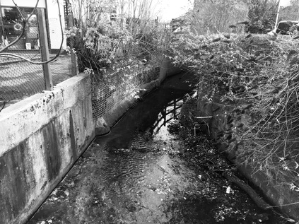
This short stretch of Watling Street did however take me over the Edgware Brook, a filthy and rather noisome stream which curved under the road in a concrete culvert near to the junction where the A5109 turned east - and where my walk began in earnest. The rise of the road as I headed into the suburbs indicated that I was heading for the higher ground where the headwaters of the River Brent rise and that I'd be crossing numerous tributaries which snaked together to form the Silk Stream and the Dollis Brook, converging at a point I'd passed on a previous walk. It was hard to read this suburban climb as an A-road at all as it slowly ambled between pleasant inter-war semi-detached homes. Deansbrook Road rose gently towards the bridge which carries it above the Northern Line on its final stretch towards Edgware and the watercourse for which it is named. The Deans Brook rises on the high ground of Scratch Wood, taking in the waters of the Edgwarebury Brook, the Edgware Brook and the Burnt Oak Brook before becoming the Silk Stream near Burnt Oak Station. A footpath descended to snake briefly alongside the brook before passing between the houses below, but it wouldn't have taken me further along my route. Instead, I followed the road to its first junction, an unremarkable suburban roundabout where it turned illogically north to skirt the edge of Mill Hill. The road climbed again and began to curve towards the east, with the impressive hulk of John Keble Church gradually revealed ahead - first the golden brick of the tower, then the stepping bulk of its nave. Designed by D.F.Martin-Smith, the church was consecrated in 1936 and Grade II listed in 1989, the slender louvred tower dominated the view uphill with Keble's name inscribed in stone above a stylised eagle - emblematic of a poem in his Christian Year. Reportedly, this is the only church dedicated to Keble, the humble but influential poet-vicar who formed part of the Oxford Movement. It sits on this rather inconsequential spot, a formative step in modern church building. In 1958, Martin-Smith, then in partnership with Henry Braddock went on to build the swooping brick and concrete St. Mary's in Crawley - a more ambitious and challenging building, but perhaps one that sits less comfortably in its surroundings than this arresting hilltop structure?
The road continued to head northeast, passing through the rather drab shopping zone at The Hale - one of the several knots of urban life which make up Mill Hill. There is no real centre to this suburb, in part due to the haphazard railway development which saw a single-track line from Finsbury Park to Edgware opening in 1867 with the plan to expand when traffic grew. In the event, the High Barnet branch was much more profitable and the second track was never laid. The line languished on with a shuttle service to Finchley until 1935 when the London Passenger Transport Board's New Works Programme proposed to link the suburban lines from Finsbury Park into the Northern Line and to use a long-established right to build rails beyond Edgware to Bushey Heath. The complex web of Northern Heights lines would thus feed into the branches of the Northern Line, and would link the suburbs to the city - but the war intervened, and little was achieved beyond electrification to Mill Hill East. The line beyond this was abandoned and now provides a TfL supplies depot, a nature reserve and an intermittent and somewhat forlorn greenway between Edgware and Mill Hill. Beyond The Hale, the road climbed steadily to another of Mill Hill's scattered urban loci at Apex Corner. The origin of the curious name for this spot appears lost in history, but likely refers to its relative elevation and the meeting of the roads to Watford and Barnet. The modern incarnation of the junction sees the A1 and A41 sweep in from the south as a single, wide road before dividing at the roundabout and heading in their respective directions. Meanwhile, just feet from the roundabout and entirely disconnected from this earlier incarnation of the trunk road network, the M1 thunders in a cutting alongside the Midland Mainline to St. Pancras. By the early 1960s, the junction had acquired its current configuration, swirling around a sunken pedestrian area with a tiled bank of chequerboard stone raking up to the road and solid stone portals providing access to the radiating footways. At some point, Apex Corner must have been a busier spot for walkers, but now the junction is a bleak prospect on foot. While one corner retains a typical suburban retail parade now operating the ubiquitous mix of betting, tanning and eating establishments, housing has largely encroached elsewhere. But on the northern flank, between the arms of the roundabout which stretch out to Watford and points north, a drive-thru KFC and a Shell filling station provide necessary services to those who are sticking to the old routes. Apex Corner is the ghost of a staging post on the road north, and while traffic rumbles north on the nearby motorway, this oddly bleak circus sits on its hilltop looking beyond London.
My route was briefly with the A1, before the A5109 turned northeast at an awkward afterthought of a divergence, necessitating traffic skittling across the central reservation after being freed of the gravity of Apex Corner. The main road continued north, a silvery ribbon of tarmac heading out of the suburbs and rising into the greenbelt which curtailed London, allowing the green spaces of Scratch Wood and Moat Mount to remain undeveloped. The scene reminded me of the vintage 1980s logo adopted by the London Borough of Barnet, featuring a sweep of dual-carriageway snaking around oversized trees. The woods here were once threatened by the semi-mythical Stirling Corner Link - a road joining the M1 and the A1, and the first chance for northbound traffic to leave the motorway at Junction 3. This junction was never completed, with three-quarters of a roundabout forming awkward access to London Gateway Services instead. The road, if built, would have carved through the top of Scratch Wood, sending sliproads arcing over the A1 and descending into Thistle Wood in at least one version of the scheme. The planned Junction 3 was part of the 1961 plan for the M1 which had it ploughing on to Marble Arch, unhindered by anything in its path. The more modest Hendon Urban Motorway opened in 1967 without Junction 3 and sputtered to a premature halt near Fiveways Corner rather than relentlessly progressing into the West End. Various references in the National Archives to soil slippage at Scratchwood and expensive remedies needed for shifting concrete walls along this section of the route may give a clue to why this was the case. However, the plans remained resolutely part of the future development of the motorway until being quietly shelved in the straightened public spending round of 1976. The link road concept has resurfaced at times, not least in 1989 as part of the Roads for Prosperity plans - getting as far as an invitation for prospective builders to tender on that occasion. But in 1994, the plan was finally killed for good, and the services continue to delight in the most bizarre and confusing access routes in the land. The green spaces remain, quiet and undisturbed - at least for now...and I was soon to find myself practically out in the country, despite being firmly within the confines of Greater London.
There was a distinct shift as the road climbed Highwood Hill - suburban semis became large villas and gated dwellings of impressive scale, and the cars outside properties were newer and far fancier. At the peak of this first climb, the pavement switched sides, the first of a number of times I'd need to cross the A5109 as it became essentially a country lane. This rural byway however saw traffic at North London speeds and densities and even had a regular service of red double-decker buses. This was an indication that my sloppy categorisation had been accurate - this was an orbital route in the same way that some of its more impressively proportioned relatives further south were being used - the most direct route from somewhere to somewhere else, even if not the officially sanctioned means of crossing London. Satellite navigation has changed behaviour here, and the most direct route is suddenly open to even those who don't know the terrain. You can detect them - barrelling into corners and shifting gears erratically to scale hills, but utterly unaware of what lies beyond. They trust the instincts of the machine, and mostly it works out for them - and so they continue until they're let down by the technology in some dead-end. Even then, they'll usually allow the algorithm to re-route them out of trouble. Highwood Hill was an exclusive address as early as 1825 when Sir Stamford Raffles, fresh from his colonial exploits in Singapore and the Far East returned to live out his last days here. While Raffles was a proponent of colonial reform, his ideas were perhaps not entirely in tune with the great reformer and supporter of emancipation William Wilberforce, who retired to his own property nearby just a year later. In declining health and having retired from Parliament, he survived long enough to see his campaigning result in the final Commons reading of the Abolition of Slavery Act in 1833. At the crest of the hill, between the sites of these two gentlemen of the Regency era, Nan Clark's Lane leads north into the fields - marking a final retreat of an entirely other nature. Nan Clark was a barmaid in The Rising Sun with many admirers but wed to an exceptionally jealous husband. When rumours of an affair reached him, he is reputed to have dragged her by the hair along the lane to a lake where he drowned her in front of a horrified audience who had followed them from Highwood Hill. The legend has spawned a range of stories of supernatural goings-on which are sadly the only record of Nan Clark now. Fuelled by the presence of the lane and with The Rising Sun still trading nearby the legend is a popular local ghost tale that adds a slight frisson of the rural English gothic to the estate agents patter when they're flogging property on the overheated market in NW7.
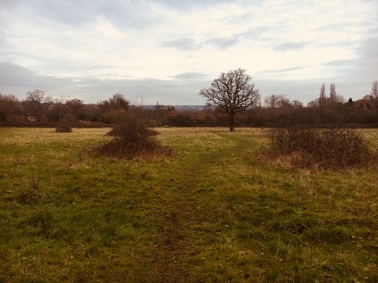
Shortly after reaching the peak of the hill both pavements gave up completely, the road narrowing and curving menacingly into the next rise. Relying on my map, I headed through a gate and into Totteridge Fields. This local nature reserve is perhaps not at its best in December, but the faint sunshine and the glorious sweep of ungoverned green was a welcome relief from the road. I squelched diagonally across the former hay-fields, which narrowly escaped conversion into a cemetery in the early 1990s and which are now leased by Barnet Council to the London Wildlife Trust. Aside from a well-kept information board and some sturdy kissing gates, they've left the land to run wild and the desire-line I followed was ghosted by the skeletons of autumnal weeds and wildflowers bending in the breeze. At the edge of the field, I crossed a tiny brook by way of a wooden bridge, realising that this was one of the barely trickling sources of the River Brent which had seemed such a broad and mighty presence on my last walk. Here I could press onwards to find the London Loop which meandered along with the nascent Dollis Brook nearby, or I could double back towards Totteridge and the road. I felt duty-bound to do the latter, and after scrambling over a muddy stile worked my way up an indistinct footpath lined with frequent dire warnings not to stray. The waterlogged scramble eventually brought me to a drive between two impressive farmhouses, and then back to the road. This was Totteridge - a long, straggling village set in former Manorial lands now in trust to a private association. Each house, set back and discreetly screened from the road, bore its name on a curved, white painted stake on the road. A footpath was tolerated but often ill-kept and ruptured by ancient roots. No-one walked this stretch - it was too important to be seen in the right kind of motor car, cruising by the long ponds which lined the southern flank of the road. Nothing interesting was happening here, and everything was just so - the Manor's groundskeepers ensuring that the carefully preserved and jealously guarded lack of event was undisturbed. The scenery was green and pleasant, but I must confess utterly dull and surprisingly charmless. The road curved and descended a little towards the Dollis Valley and a few fellow walkers appeared, surveying my muddy and leaf-caked boots with disdain and alarm. They headed for The Orange Tree, a vast rural pub with a well-stocked car park and an enviable menu of gastropub delights near the edge of Totteridge. Eventually, at the foot of the hill, I found the anonymous parapet where the Dollis Brook headed under the road on route to Welsh Harp. The footpath into Whetstone Stray, alongside the churning waters which had already gathered some surprising pace and width since I'd seen their tiny tributary a mile or so back, was tempting - but the road needed to be walked to its conclusion. Up ahead, the A5109 shuddered to a halt at a staggered crossroads not far from Totteridge and Whetstone station. This little knot of urban normality felt like a relief after the forced conservation of Totteridge. As I navigated around an angrily accelerating driver who was hot on my heels as I completed my crossing of the road, I didn't spot the Whetstone until I had passed by. This stone of unknown origin appears to have been used as a mounting block beside the tollgate which controlled access to the Whetstone and Highgate Turnpike here until 1863.
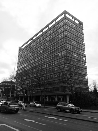
On the corner where the A5109 meets the former Great North Road stood Eveready House - now known as Barnet House, a strikingly modern block built in 1966 by Richard Seifert for the British arm of the Eveready battery company. Gravity-defyingly bulky, the building stands on pleasingly solid-looking stilts above the ground. Seifert's almost impossibly prolific output in London alone produced such a mix of wonderful, terrible and downright ordinary buildings that it is hard to approach preservation of his heritage - however, as the building was adopted by Barnet Council in 1986 its recent fortunes have remained fairly assured. It is difficult to imagine how such a substantial block this far out of the city could survive for long without this public patronage, however. My next stretch of road departed the former A1 route directly opposite the building, the surprising suburban bulk glowering over the rather innocuous beginning of the A109. This road has always been numbered thus, unlike the A5109 which was until the 1940s a lowly B-road - but it has a sort of deferential air, giving way to other roads and allowing them precedence at junctions. The A109 comes into its own for just the kind of local in-the-know traveller I've talked about before - for whom the journey across and within the city is more important than simply getting to or from London. The village centre of Whetstone clung to the road for a spell, allowing me to find some much-needed sustenance - it had been quite a hike up from Edgware and I was wondering if I'd set myself a challenging walk in the time available today. I rested briefly on a damp bench among a disarmingly constant stream of pedestrians - it felt like I'd been largely alone for much of the morning, and needing to weave around people was an odd new feeling. I set off again, heading downhill now with surprisingly good views to the east. This was the largely unremarked suburb of Oakleigh Park, lining the route with pleasant, suburban homes which for a decade from 1941 housed a secret listening station for the Soviet news agency, TASS. The plug appeared to be pulled by the Security Services in 1951, but only after Barnet Council had unsuccessfully tried to close the station on planning grounds. The road continued south, bridging the railway at an awkward angle before running alongside it towards the city. The sliver of land to the west of the road was hemmed in by the tracks, and when it finally became broad enough to be useful hosted a string of industrial units and building suppliers. The road was quiet here - there are lots of better ways of getting across town nearby and the A109 is left to its rather forlorn own devices. Only buses and the occasional white van heading for one of the local businesses passed me as I trudged on into a purple, brooding sky. It felt like the night was already encroaching and I fell into a reflective frame of mind as I walked south, thinking about how this route was now converging with other walks: the valley of Pymmes Brook ran parallel close by to the east, and I was once again converging with the North Circular on its relentless arc. These northern zones which once seemed so unreadably vast and dull were becoming strikingly familiar in parts but still maintained a capacity to surprise me with a sudden view or diversion.
The A109 began to climb again near New Southgate Recreation Ground, part of a swathe of green space which stretched north to the Pymmes Brook valley and Brunswick Park, crossing the spoked wheel arrangement of the cemetery. This site - then known as the Great Northern Cemetery - would have been the first to offer cremation in the UK in 1861 had the Bishop of Rochester in whose diocese large parts of suburban North London still sat, not replied that he had neither the will "nor the power to allow such a mode of disposal of the bodies of the dead". The Cremation Society persisted in its efforts, and finally, the first cremation of the modern era took place in 1885. The Cremation Act followed, passed in 1902 to authorise burial authorities to establish crematoria but also to outlaw open pyres like that used by the self-ordained Druid Dr. William Price to dispose of the body of a child fathered to his housekeeper. At the peak of the rise, the A109 again deferred to other roads at the oddly named Betstyle Circus. This little urban cluster in the suburbs seems confused - either masquerading as Friern Barnet or New Southgate and with the boroughs of Barnet and Enfield erratically switching territory around the spokes of the roundabout. My route unexpectedly took the easterly exit here, before swiftly turning south again to pass by New Southgate station. Across the rails and above the trees the impressive buildings of Friern Hospital could be seen, formerly the Middlesex County Asylum and now an exclusive housing complex. The boundary of the boroughs edged along the railway here, with the road falling into step beside both until it dog-legged to the east to skirt the site of the former New Southgate Gasworks, now given over to a vast builders trade supply business which sat atop the arches of the railway siding which once served the site. The single remaining gasholder reminded me I was approaching the North Circular once again, and encountering a familiar view from a different direction. A new development of apartments was slowly rising beside the pavement here, wedged into the corner created by the A109 and the Bounds Green Brook. The hiss and shudder of the busiest road I'd encountered since leaving Edgware was evident before I could even see it stretching along the valley floor, bisecting my onward route which climbed the valley ahead of me. I had no business with the A406 today, but I did need to cross the six lanes of traffic here. The crossing had an entirely different impact approaching from the north, and the road felt more like an imposition on the landscape from this aspect. As I waited for the lights to change, the sole pedestrian in sight I supposed, I noted a small group huddled on the central island. Occasionally when a stream of traffic braked hard for a red light, they would groan and rise, tottering at first on uncertain legs, before working the stream of cars. Some, the most downtrodden and disabled among them, would beg in the most direct sense. Meanwhile, a more enterprising younger man in a hi-vis vest he'd probably retrieved from the verge of the road sold multipack cans of Diet Coke and bottles of water from a shopping basket. This probably worked well in a summer traffic jam, but on a grim December afternoon when snow threatened, drivers seemed less inclined to buy. As the lights changed and I crossed, the forlorn group repositioned to ply the next queue of traffic. I hadn't noticed these people when I made my way along the North Circular. Had they been there, and my onward focus too unwavering to miss them? Or had they been obscured by others using the crossing that day? For all that's said about my introversion and self-absorption - especially when I'm walking - I'd hope that I wouldn't have overlooked such a sorry scene taking place in the midst of this unsheltered tarmac plain? I completed my crossing and began walking up the hill which climbed out of the valley of the Bounds Green Brook. Looking back, the figures were only barely visible, scuttling and hobbling towards cars in a display of surprising optimism each time the lights changed.
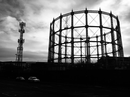
It was possible to walk along a surprisingly broad area of green space beside Bounds Green Road, which rather reminded me of its appearance on early maps of Middlesex as a country lane in a wooded channel between the fields. Suburbia had encroached by the late 19th century, with Wood Green sprawling inexorably towards Southgate as Londoners moved out of the city along the railways. Bounds Green however seems to have stayed surprisingly upmarket, with many fine old houses ranged along the terraces beside the road. Not all remains of course, and around the twin brick towers of Newbury House and Finsbury House is a small estate of modern, low-rise housing which feels a little unloved and in need of refurbishment. Nearby, in surprising contrast is the red-brick and white stone Braemar Avenue Baptist Church, an unusually decorative approach to a non-conformist chapel and a reminder that Wood Green and Tottenham were hotbeds of religious dissent. The congregation relocated to this fine building in 1907, having previously assembled in a range of homes and halls across the area. I'd encountered the church during my walk along the New River Path, and I soon crossed the route of the river's tunnel which meant I was closing in on Wood Green. One last surprise before I plunged into the urban maelstrom of 'The Mall' was the obelisk dedicated to Mrs Catherine Smithies which sits on a patch of ground outside a rather gentrified run of shops and pubs. Smithies was responsible for the formation of the Band of Mercy - an organisation that aimed to teach children kindness and humanity to animals in the hope of creating a future world peopled by peaceful adults. Smithies modelled her new organisation on the Band of Hope temperance movement initiated by the Baptist minister Reverend Jabez Tuncliffe in Leeds. By the end of the century, the RSPCA assumed responsibility for the Band of Mercy movement, though it continued to grow in strength in the United States through the work of George T. Angell who restated the organisations aims to:
[...] teach and lead every child and older person to seize every opportunity to say a kind word or do a kind act that will make some other human being or some dumb creature happier.It felt rather odd to see Wood Green as a cradle of kindness and religious diligence as I approached a crossing the High Road. The flank of Haringey Civic Centre with its pleasing brick and stone lines betraying its origins in the late 1950s. From the rear, a dramatic wing of the building strode out across the car park on stilts with metal stairs elbowing into view, partially obscured by St. Michael's Church. A little further along the street, the Fishmongers Arms was a reminder of the Fishmongers and Poulterers Almshouses which occupied this site before it was a seat of Local Government. I crossed the street near the rather drab little scrap of park dedicated to King George VI which had been occupied by a dedicated drinking school on my last visit. Today it was empty, the cold weather and the stream of pedestrians heading for their festive retail destinations driving out the locals. I turned towards Wood Green with some trepidation...
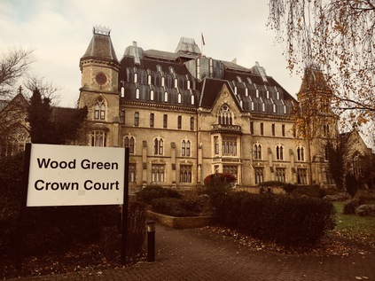
I wasn't sorry to make the turning into Lordship Lane near Wood Green Underground Station. The pavements were impassably busy, with people darting between streams of travellers emerging from the tunnels and some testy exchanges as they cannoned into each other in their haste. Pedestrians were laden with bags or staring into electronic devices, always too occupied to focus on their surroundings - and it struck me that I was the only person in this strange little urban swirl who was walking for the sake of the act. No wonder I was regarded oddly, my boots and trousers marked by dried-on Middlesex earth and my face masked by a scarf against the cold and fumes. A little south of here, somewhere under the massive brick ziggurat of Wood Green's mall, was the site of Alderman's Bridge where the River Moselle passed under Green Lanes and formed the edge of the building plots on the southern side of Lordship Lane. The road quickly reverted to suburbia, leaving the chaos of the shopping centre behind. However, the rather uniform buildings suddenly gave way to the somewhat bizarre Wood Green Crown Court building. Originally built as the Royal Masonic School for Boys, supporting the children of deceased and poor Freemasons, the building remained as a place of education until the 1930s when it was acquired by the Tottenham and District Gas Company and renamed Woodall House in honour of Sir Corbet Woodall, former chairman of the Imperial Gas Light and Coke company who is commemorated by a statue now at Twelvetrees Crescent in Bow. After nationalisation in 1948, the building found use as the headquarters of the Eastern Gas Board. In 1974 it was acquired by the Borough of Haringey and modernised to become Wood Green Crown Court and Remand Centre. The building's current appearance, with a dramatic and somewhat strangely mountainous roof filling the gap between the tower on each flank dates from rebuilding after an arson attack in 1989. The Court continues to find new ways of remaining in the public consciousness too - seeing Britain's first juror jailed for using the internet in contempt of court in 2013. Today, all was quiet outside the building except for a group of drinkers loudly discoursing in the garden - I couldn't help but wonder if they were the displaced group from King George VI Gardens, relocated to a more exclusive spot to avoid the crowds. Perhaps they are part of the civic fabric of Haringey?
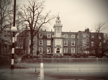
I continued to head east, aware of the Moselle's hidden course nearby, recalled in the street names if nowhere else. I remembered my walk to find the remains of the river in a heady, turbulent summer five years ago. I hadn't quite imagined the turn my walks, or indeed my life would take after that. As the pale and stark towers of Broadwater Farm rose above the terraced houses lining Lordship Lane appeared, almost fading into the purple-grey sky, I spotted a housing development much more modest and human in scale as the Tower Gardens Estate edged against the road. This was the London County Council's well-intentioned but somewhat half-hearted attempt to bring a little of the Garden Suburb approach to deepest Tottenham. Built between 1904 and 1913, the semi-circular estate of cheaply but attractively built cottages is encircled by The Roundway, a diverted arm of the A10 which takes it away from its old course through Edmonton and onto a menacingly busy urban dual-carriageway. This means that Lordship Lane becomes a somewhat quiet backwater near Bruce Castle, the grand manor house built and modified over a long period of the 16th, 17th and 18th centuries. An early occupation by Sir William Compton, one of Henry VIII's most prominent courtiers is recorded, with the building variously changing hands through seizure, debt and sale across the centuries before falling into the ownership of John Eardley Wilmot who as a Member of Parliament was charged with leading a 1783 commission investigating the events of the American Revolution. He also presided over the rather lesser-known effort to provide housing and alms to 60,000 loyalist refugees who returned to Britain after Independence was declared. By 1827, Bruce Castle had become a branch of the Birmingham radical school operated by Sir Rowland Hill and his brother. Hill moved to Tottenham to become the headmaster of the new school, and his later career would take in planning the colonisation of South Australia and reform of the Postal System. Meanwhile, Bruce Castle found its final incarnation as a museum and garden in the ownership of Tottenham Council by 1906. It remains a similar facility today, under the stewardship of the post-1965 London Borough of Haringey, a rather odd intrusion of history into the heavily and relatively recently developed hinterlands of Tottenham and Edmonton. Incidentally, no castle has in fact, ever stood on the land here - though large tracts of the area were owned until his accession to the Scottish throne in 1306 by Robert the Bruce. The manor here is recalled the rural setting which Bruce would have known in John Abraham Heraud's 1820 epic poem 'Tottenham':
Silent and lone, and on the greensward dies -
But when on ye her heavenly slumber lies,
TOWERS OF BRUS! 'tis more than lovely then. -
For such sublime associations rise,
That to young fancy's visionary ken,
'Tis like a maniac's dream - fitful and still again.
Outside Bruce Castle I faced a choice. Technically, the A109 continued for a few hundred yards towards Edmonton where it came to an end on the old High Road. However, I'd walked that last stretch before and had found it a rather gloomy stretch of route somehow. Beside me, Bruce Grove cut the corner, heading directly south-east towards the station with which it shared a name, and taking this turn could save me from ending my last walk of the year at a drab, inconsequential crossroads. I paused for some time, deciding whether to break my self-imposed rules here. It's true that this was perhaps the last of these 'orbital' walks in the North, and it felt odd to be changing the plan at this late stage. But I'd walked for miles, the light was beginning to fail, and the chill damp of the afternoon was finding its way to my bones as I tired. I reasoned that it had been a long, challenging year of walks - and it should at least end by covering new ground - and so I broke my rule and struck out along the previously unwalked line of Bruce Grove. The station beckoned, the railway bridging the junction ahead, declaring the location in bold white letters on the blue ironwork. The sky had turned a pinkish-grey as the weak winter sun fell and the streetlights were developing halos in the frosty air. It was the perfect way to head back towards civilisation. I had almost walked the length of the A5109 and the A109, an arc across the northern reaches of the old County of Middlesex - a deleted administrative unit which had come to figure largely in my travels this year. Descending into the Lea Valley from the Northern Heights felt like a perfect way to enter the seasonal pause in my walks. My decision not to cover those last few yards niggled at me - but as I boarded the train for Liverpool Street, I found myself sitting across from a young, smiling woman who was devouring an artisanal doughnut with enviable guilt-free glee and happiness. It was impossible not to get caught up in the sense of contentment: my feet ached from a walk completed, I had a host of surprising finds to unravel and research, and as ever new twists and turns had suggested future exploration on the way. Perhaps rules were meant for breaking after all?
You can find a gallery with more pictures from the walk here.
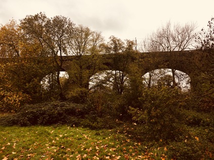
Heading west out of Paddington, minutes after arriving, felt very strange indeed. A few minutes later, as I waited in a steady downpour outside Ealing Broadway station for the bus to Hanger Lane, I tried to rationalise my persistence with today's endeavour. I needed to walk... It had felt like a tough few weeks, and I knew I had an equally challenging month ahead. I also felt like I had unfinished business out here - and despite feeling like a trudge along some damp eastern pavements might have been a far more sensible idea given the promised poor weather, I'd been drawn back to the River Brent which had proved so elusive and wayward on my last walk here. When I'd left the river last time, it had been a reluctant parting - I'd figured that Brentford and the Thames were mere miles away, and ought to have been easily reached had I stepped up the pace and not been confounded by diversions. Thus today's walk felt like it might be worryingly short and on the way into London I'd been concocting possible additions and extensions to fill the day. As it was, the Brent more than occupied my time today, and the walk was not as short as I'd feared...
Sheltering in a shop doorway, just out of reach of the spray from cars hurtling around the Hanger Lane Gyratory, I deployed the hood of my coat and tried to secure it in a spot which didn't wholly deprive me of my senses. Prepared, and steeled for the rain, I set off - much to the amusement of some of the passengers on my bus who had watched me preparing to get going. I realised from my reflection that the look of grim determination I was wearing must have seemed oddly out of place as I strode off along the slip-road down to the A40. I was starting my walk on another typical arterial road. The slick river of tar stretched ahead, red tail lamps winking into the dark distance and neon signs on the nearby buildings appearing weirdly over-bright in the gloom. I woudn't be spending long walking this road, thankfully, but the more pressing issue was that I didn't fully know how far to go. My research for this walk had focused on what seemed like tricky pathless sections further ahead, and I was striking out into the unknown a little here. As I walked, the hulk of the Vanguard warehouse near which I'd abandoned my last Brent excursion dominated the view west. Ahead of it, the river passed under the A40 via an unremarked bridge. I'd been so close to the water before, but tantalisingly it lay just out of sight, between the road and the railway. Near the bridge a wooden kissing gate led into a grassy space beyond and I'd have probably ignored this save for the 'Brent River Park' direction indicator on the post. Beneath, the river was a grey rush - swollen with rainwater from the heights of Middlesex, its course was more urgent and turbulent than when I'd last been beside it. I was reluctant to head into the field given how wet things were, but it couldn't hurt could it? I swung through the gate and left the road behind. The river curved to meet the flattened path, a carpet of fallen leaves providing me with traction underfoot. This was already beginning to feel like the right direction to head in...
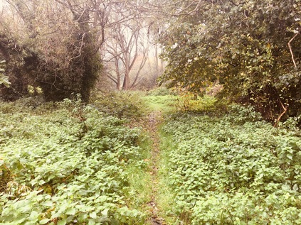
The river wound around the edge of a golf course, providing a boundary between the primped greens and fairways and the much more democratic municipality of Pitshanger Park. I followed its course as closely as I could here, remembering how tricky it had been to walk alongside the river further upstream. The scrubby fields between the road and the park were deserted except for a lone dog walker who patrolled the perimeter, eyeing me with a little suspicion as I trudged carefully around some of the wetter spots on the path. The river turned west, and I needed to retreat to the roads to find it again, doing so via an inelegant clamber over a stile and into the attractive and quiet streets of Brentham Garden Suburb. This rather sleepy and at first unremarkable estate is in fact an early example of a cooperative housing development built to incorporate Ebeneezer Howard's principles as outlined in 'To-morrow: A Peaceful Path to Real Reform'. Published in 1898, this work kickstarted the Garden City movement which suggested the possibility of enjoying the conveniences of city life in almost rural settings. With construction beginning in 1901, Brentham pre-dates its better known and now rather exclusive cousin at Hampstead by some years but being a little further out of the city, isn't perhaps well positioned to become the haunt of the well-to-do and famous. Walking west, towards an entrance to Pitshanger Park, I watched the estate waking up - supermarket delivery vans puttered between streets, families wandered outdoors, wrapped in winter clothes. The rain had almost stopped as I turned into the park entrance which was guarded by a gang of gossiping dog walkers, their bored hounds grunting and sniffing at the floor in anticipation of their excursion recommencing. I set off across the park to its northern boundary where the river was hidden behind a line of trees. There were few others in this part of the park away from the sports club and café, and while still a little damp my walk was quiet and pleasant. At the edge of the park I turned north along a narrow hedge-lined alleyway cutting through the golf course. The river, after being joined by what appeared to be the stub of a forgotten tributary or former diversion, also turned north, and through the hedge I could see it winding between greens and fairways, providing a genuine challenge to errant golfers.
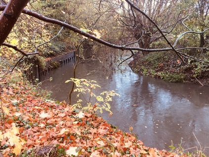
The path divided near a wooden bridge over the Brent, marking the point where I'd expected to enter the park had my excursion through the fields not proved viable. I turned west again, rejoining the river as it took a broad loop to the south and then north along Argyle Road. A detour here took me close to the riverbank as far as Perivale Lane where I feared I was trespassing on the grounds of St. Benedict's School. I tramped back to Argyle Lane, retracing my steps rather than following an arc around the playing fields of a leisure centre which, while closer to the river were clearly muddy and very wet and offered no clue about how I'd escape at the other end. I began to fear that perhaps the Brent was to be as elusive today as it had been on the first part of my walk in from Finchley. I headed west along Ruislip Road East, a long straight route running directly from Ealing to Greenford which the borough had recently improved to favour walkers and cyclists. Frequent banners hung from the fence behind which the river ran, informing me how this five-mile long route was safe, well provided with frequent crossings and speed controls and could enhance my health and wellbeing. Indeed there did seem to be a fair number of people wandering back and forth as I passed under the railway line from Greenford with the Brent churning darkly under the adjacent arch of the bridge. The road began to rise towards a junction with Greenford Broadway, crossing the river by way of an ornate bridge. Beside the bridge a gap in the fence provided a surprisingly anonymous entrance to the continuation of the Capital Ring walking route. I'm still asked fairly often if I'm 'doing' this walk - and equally often I'm told how unattractive and borderline dangerous my questioners found the walk. At this point I'm forced to grit my teeth and suggest that I'm not walking the route but inevitably I'm encountering parts of it on my travels. I'd love to add that circling a vast, complex city like London is bound to take a walker through a variety of landscapes which make up the edgelands, but I suspect they're already busily ticking off their next sanctioned and sanitised walk somewhere. After a brief pause to buy lunch I returned to the inconsequential gap in the fence and plunged into the cool, quiet tunnel between the trees which lined the river here. Near the road there was the usual evidence of temporary occupation: blue carrier bags, Polish lager cans, the marks of extinguished fires and discarded clothing - but soon these petered out too, and it was just me and the river. The Brent was wide and fast-flowing here, swirling with rainwater from the numerous streams and gullies which joined it on its suburban journey. This wedge of parkland, hemmed in by a recycling centre and a large development of inter-war housing was almost entirely deserted. The sky churned overhead, but promised brighter conditions might be coming later, and I happily trudged south, the river tumbling and twisting beside me. The way was marked by infrequent wayfinding posts, and one of these sent me down a flight of wooden steps cut into the steep valley side and onto a rarely walked diversion on the bank of the river. Unsure if this path would safely return me to my route without a muddy scramble, I was a little uneasy about heading onwards - but the lure of the water was strong and I'm glad I continued. This was the closest I'd managed to get to the Brent so far, and it felt good to be walking beside it more directly for a short spell as it cascaded over a weir and swirled around hanging boughs of trees which leaned down into its surface. Returning safely to the path further ahead, I crossed a bridge and found myself on a comparatively well-made stony path passing directly through another golf course, marked by signs warning me that by passing them I accepted the risk of encountering low-flying balls. There were few golfers braving the unpredictable November weather today, so I gladly took the chance and continued. The river was to the east now, denoted by a snaking line of trees beyond the flags and bunkers, and I once again wondered how much more of it I'd manage to see? Above the trees, the steeple of St. Mary's Church in Hanwell was a black silhouette on a turbulent and dramatic sky which seemed to shift to dominate the view from every direction as the path turned with the river. There has been a place of worship here for well over a thousand years, and it struck me that the development of parks and golf courses around it meant that it still provided a landmark from some distance away with little encroachment by other tall buildings. The path rejoined the Brent, crossing it by way of a solid but scruffy metal bridge, and then divided again - the more formal sandy track leading up to the church while a series of wooden flets sunk into the muddy bank took the path into a broad meadow and towards the curve of the river again. I chose the muddier path and stayed with the Brent.
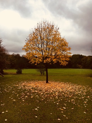
At the top of the steps I found an expansive park, surrounding the fences of Hanwell Zoo and allowing me to take a wet but relatively mud-free excursion along the riverbank as it wandered east around the edge of the Millennium Maze and into Churchfields Recreation Ground. The thunder of trains could be heard over the chatter of children and braying of goats, apparently the only animals braving the wet weekend morning in a compound at the back of the zoo. It occurred to me that I'd soon be passing under the Great Western Railway which had brought me into Paddington a few hours ago, the twists and recursions of today's journey echoing the contortions of the Brent. Now though, the river slunk quietly in a low gully at the foot of the park, screened by high trees and hedges which hid the graceful arches of Wharncliffe Viaduct from view until at the foot of the sloping parkland one of the great arches leapt into view, gracefully crossing the path and the river. This awe-inspiring structure was one of the earliest projects attributed to Isambard Kingdom Brunel, and also one of the first completed along the route west from Paddington to Bristol with trains running above from 1838. The viaduct also has the honour of being one of the first buildings 'listed' for preservation in 1949, and such forms a key part of the bid to have the whole original GWR route named a World Heritage Site. While it remains unclear if Queen Victoria really did insist the Royal Train pause on the viaduct to let her enjoy the view along the Brent Valley, there are now others who linger here - namely a vast colony of bats which live within the hollow archways. The river turns south again here, initially in a brick culvert which neatly brings it alongside the path and under one of the easternmost arches of the viaduct. Looking along the structure, its grace and scale are overwhelming, and perhaps not fully appreciated until viewed from the hay meadow to the south of the line where Lord Wharncliffe's family arms are visible on the central span - recognition of his support for the parliamentary bill authorising the Great Western Railway. I paused here, trying to get a picture which would truly show the sweep of the arches over the valley, an amused dog walker letting his charge scamper in the long grass while he watched me struggling to frame the shot against a dull grey sky. Behind me as I faced the wonder of Victorian engineering, another impressive bulk of a different era loomed: the huge Ealing Hospital - a solid grey block raised above a wide pediment, with ramps leaping and curving from the ground to deliver ambulances direct to the entrances. I'd passed this way countless times, spotting the rather grim building from trains speeding west from Paddington, but up close the building felt impressive, dour and overbearing. Before reaching the Hospital, the river needed to pass under the Uxbridge Road via a low stone bridge. There was a choice of routes here - the path ascended to cross the busy road at grade, or I could stay beside the river and pass under an arch in the bridge built to accommodate the footpath. This passage dipped low, close to the river's edge and appeared worryingly waterlogged. I weighed up the alternative route up to the road, but decided that I was brave enough to attempt the slither down the stone slope and under the bridge. In the edge of the river beside me, a forlorn and slowly moulding office chair was marooned in a shallow pool of greenish water. The roof was close to my head, stippled with drips of calcification and dangling here and there with more ambitious stalactites, but the passage was uneventful save for paddling through an inch or so of water - either rainfall or overspill from the Brent which felt perilously close. The path climbed again, rising to pass close to the eastern perimeter of the Hospital, revealing the inner workings and complexities of the building, rather spoiling the illusion of the futuristic swooping concrete ramps and the rather inhuman face of the tall concrete blocks. Built in 1979, the site fills the nook between the River Brent and the mainline of the Grand Junction - latterly the Grand Union - Canal. To the west of the current hospital the former Middlesex County Asylum, opened in 1831 remains in use as a modern psychiatric unit, still sequestered behind a solid red-brick wall. Known for some time as St. Bernard's Hospital, the facility pioneered early forms of occupational therapy under Dr William Ellis its first superintendent, and was later instrumental in the removal of restraints in favour of less invasive means of protecting patients, including the padded room. The relative humanity of the regime at Hanwell under Ellis is evident in his principled resignation upon learning that the Commissioners and Justices wished to cram more patients than he felt could be properly be cared for.
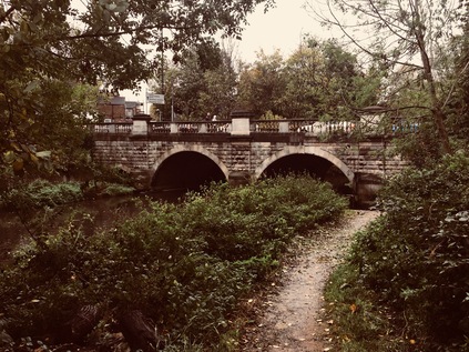
This corner of Hanwell also holds a significant place in the nation's industrial history. Beyond the hospital the path divided, with a spur leading up to the towpath of the canal at the bottom of the Hanwell Flight - a series of six locks with associated balancing ponds built in 1794 to bring the Grand Junction to the level of the Brent, with which it merges nearby. As I emerged beside the bottom of the flight, two young couples were beginning the ascent of the flight, enjoying the sunshine which had finally escaped weakly from the cover of low cloud and not yet tired from, or perhaps fully cognisant of, the effort required in operating the six locks to raise their boat through fifty-three feet. I was tempted to follow the canal but I stuck with the river path as long as I could, taking the path which shadowed its last sluggish twists between the cottages on Green Lane and the canal, before finally reaching the junction under a brick bridge. From here I would be walking the southern part of a route which was navigable to Birmingham and beyond, and which had revolutionised transport in the 18th century. The River Brent, for a time at least, was subsumed into the wide, businesslike line of the canal - but it wasn't entirely absent. The river's meanders and twists as it approached the Thames largely dictated the course of the canal. Where the meanders were too tight and wide the river branched from the canal into foliage-choked and litter strewn loops which tumbled busily over weirs while the canal took a more sedate route through the wide green spaces of Osterley Park. The grand house here has its origins in an Elizabethan Manor which, at a respectable distance from London attracted the Child's, a well-connected banking family who in 1761 engaged Robert Adam to rebuild the house which was by then in considerable disrepair. Osterley House was once set in open countryside, and while its immediate grounds remain a park in National Trust management, a surprisingly large area of apparently unmanaged open land which would once have been part of its substantial grounds shadows the Brent here. To the east of the river this has become a managed wildlife area, part of the chain of spaces which make up Brent River Park. To the west the former Great Western Railway branch to Brentford runs broadly in parallel, passing the curiously named Trumpers' Crossing nearby. On the towpath, a large sign notes the location of the prize-winning length of pile in the 1959 Kerr Cup Pile Driving Competition. This contest, apparently organised by British Waterways, appears lost to history - even Google largely drawing a blank except for references to the sign itself. Both canal and railway pass under a more modern transport innovation here too, with the M4 sweeping above on a curving route into West London via a practical and unadorned concrete and iron overbridge. The traffic shuddered and screeched above, the notoriously bottlenecked road seemingly flowing freely for a welcome change.
For a while, the motorway, railway and canal ran in parallel along the broad lower Brent valley. The river meandered to the east here, passing around large wooded islands under the road, traffic above seeing a carpet of treetops below and largely unaware of the presence of the waterways. The towpath climbed over the river by way of an elegant iron bridge spanning solid, brick piers. Beyond the fence the silent machinery of a waste transfer station waited restlessly for the next load of detritus from the suburbs. This was once Brentford Town station on the somewhat unloved Brentford Dock branch, Brunel's final railway project before his death. The aim was to secure a GWR connection to the tidal Thames at Brentford - but the line struggled from the start with objections to its construction raised by the Grand Junction Canal Company and the Duke of Northumberland, owner of nearby Syon House. When eventually opened to goods in 1859, and then to passengers in 1860, the initially single track, broad gauge line failed to deliver on its promise in attracting commuters. The anticipated passenger flows to the Dock for ferries to Kew Gardens didn't ever begin operation, but freight traffic grew steadily with cargoes transferred to barges at the busy docks beside the Thames. By the time services were suspended as an economy measure during the First World War the branch was operating as a more conventional double track spur from Southall - but passenger traffic was never strong, in part because the connection to the mainline faced west making through-trains from Paddington unworkable. The London & South Western Railway had arrived in Brentford in 1849 with swift services direct to Waterloo - and the GWR simply couldn't compete. Despite restoration after hostilities ceased, the service was reduced to a peak time shuttle in 1929 and ceased entirely in 1942. Perhaps surprisingly, freight traffic continued to the goods depot at the Town Station site until 1970, with private sidings serving Firestone and other factories along the 'Golden Mile' of the Great West Road - the great mid-century sprawl of industry out to the west of London. Now the line stops short of its former crossing of the A4 while the collected waste of Hounslow, Ealing and Richmond is sifted and containerised at the railhead. Soon after passing under the road near the vast mirror of the Glaxo Smithkline global HQ, the river is bridged by the L&SWR's 'Hounslow Loop' - and with electric trains passing frequently above it's perhaps easy to see why the Great Western's branch never quite made its mark as a passenger railway. I emerged from beneath the Great West Road to find the hulking remains of an overhanging warehouse leering out into the waterway. It appeared that boats awaiting repair were now stored here, somewhat sheltered by the structure which seemed to be in the midst of a long process of overhaul. The path edged around the skeletal building, feeling oddly unofficial - this area was in the throes of redevelopment with the walkway temporarily transferred onto an unnerving floating pontoon in the canal. I trudged carefully along the queasily oscillating plastic walkway, noting the modern apartments which had encroached on the broad canal as it approached Brentford Gauging Lock. Walking here felt like trespass, and I wasn't sorry to emerge on Brentford High Street which felt down-to-earth in comparison to the eerily quiet developments along the canal.
Brentford High Street was surprisingly quiet too, with the Great West Road now taking the strain of much of the through traffic. At this, western end of town things were starting to feel the effort of gentrification - pubs were smartening up and a few specialist stores opening opposite a modern hotel building on the edge of the Canal basin. The towpath continued, descending via a slick, steep flight of stairs onto a narrow ledge which turned east along the Brent's final meander towards the Thames. This part of the walk had looked straightforward from the maps - a last trudge along the path to the confluence - but it was a surprisingly complicated endeavour. Firstly, the path was confusingly discontinuous and was often thrown aside from the water by private stretches of mooring. At one point following the path necessitated clambering up onto a concrete ledge to cross the river frontage of a timber merchant's warehouse which would formerly have received deliveries by barge. There were few people around and sparse signage to indicate I wasn't way off track - making the narrow and unclear right-of-way feel strangely menacing. The afternoon was becoming warm too, with the morning's mist and rain now a memory as the sun beat down on the water, reflecting dizzily back at me. I crossed the river again near a muddy inlet which reminded me that the River had now taken precedence again, and that this was Brentford Creek rather than the managed route of the canal. Immediately after crossing the bridge the route descended a steep staircase down to the grassy riverbank, as the more solid walkway through the Brentford Dock Estate remained private. Design of this development of homes by GLC architect Sir Roger Walters began on the closure of the docks in 1964, and building was finally complete by 1978 - the year of his retirement. Originally proposed for social letting, only around one fifth of the units were rented with leases for the rest sold by the GLC, resulting in the privately managed estate of today. In 1980 the associated Marina development was opened by the flamboyant GLC leader Sir Horace Cutler arriving by boat from County Hall. Cutler was by all accounts very keen on such showmanship, and although his administration is regarded as largely unsuccessful, he raised ideas which later found more general acceptance - not least the extension of the Jubilee Line into Docklands to spark regeneration, the promotion of the London Marathon and an audacious scheme to bid for the 1988 Olympic Games - which failed to find Government support. Cutler also correctly predicted that if elected, the Labour leader Andrew McIntosh would be ousted by the left of the party and that Ken Livingstone would become GLC leader. However, fighting the election on this negative basis seems to have assured Labour of the very victory which Cutler feared. Six years after Cutler's triumphant arrival stunt at Brentford Marina, the GLC which he had himself described as "too big, remote and shadowy" was finally abolished by the Thatcher government, nominally for those same reasons.
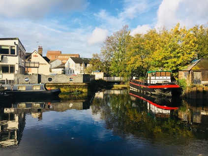
I crossed the Brent for the final time at Thames Lock - the tidal gates which controlled entry to the docks until their closure, and which still allow experienced boaters to access the Thames at designated times. The area around the lock was a pleasantly haphazard zone of chandler's yards and crumbling warehouses which transported me with a jolt to the unreconstructed reaches of the Lower Lea Valley more than a decade ago. Boats of all kinds were visible, some floating queasily askance, others hoisted from the water and in various states of repair or decay, but no-one seemed in a hurry to do much this sunny, Saturday afternoon. Here too, regeneration was slowly encroaching - and the people who I met crossing the bridge over the last loop of the river were upwardly mobile, young and optimistic looking types. Dock Road led down towards Brentford High Street which was a confusing and somewhat downbeat mix of buildings awaiting demolition, new developments and tired looking blocks from the late 20th century. A little further east I found the signposts marking the route to the Thames Path. Here, like some of the places I'd encountered the path in the east of the city, there were discontinuities and complex diversions where the riverfront rights of way hadn't yet been resolved. A short way ahead I found an alleyway which returned me to the final few metres of the River Brent at Point Wharf Lane beside some tidy and well-used residential moorings and some shiny newly built apartments stacked atop a trio of Turkish, Indian and Italian restaurants. The last mile of the Brent had been quiet and residential, and felt curiously private in nature. The river belonged to those who lived beside it and I felt like an intruder walking the path beside their homes. As the path turned east, I realised that I'd unexpectedly reached the point of confluence - and I tried to snap a picture inconspicuously over the heads a family working on their boat. I also calculated that the walk from Perivale to this spot had in fact been around ten miles in length - there was certainly no way I'd have finished this walk on my last outing, and perhaps I'd been too tough on myself for not pressing on to Brentford. after all? My estimate, minus the winding and curving of the river, had been dramatically off beam. Now I needed to head briefly back inland near the giant stainless steel swoop of Simon Packard's 'Liquidity' sculpture - a commission which had almost broken the spirit of the artist - standing resolutely on the quayside at Ferry Lane despite local homeowner's protests at its size.
The Thames Path meandered confusingly again, through a forbidding iron gateway and up a strange flight of outdoor stairs at the rear of Waterman's Park - an apparently abandoned 1970s office complex which felt like a set from a TV show. I expected to be chased along the raised brick gangway by Denis Waterman at any moment. Eventually though, I found my way through to the park proper - a sliver of green which runs along the Thames, the site of the former Brentford Gasworks which closed in 1963. A busy arts centre now occupies part of the cleansed and remediated land, and the river moorings are contested territory - longstanding residents forced out to accommodate luxury boats. Beside me the brown waters of London's river parted to sluggishly churn around Lot's Ait and Brentford Ait - a pair of wooded islets in the river. Up ahead, the tall tower of the former Grand Junction Waterworks Company loomed at Kew Bridge, marking the point where my South Circular walk had returned me to the north bank of the river. This dogged but doomed company had tried in vain to extract clean water from the Brent and the Colne, but resorted in the end to syphoning off the murk of the Thames and using the lofty standpipe tower as a means of filtering out the worst of the filth and detritus. Somehow, even when I least expected it, my walks formed connections and strengthened my sense of the city. My earlier walk along the northern reaches of the river had almost convinced me that these western tributaries would be frustrating to follow and wouldn't form substantial walks, but today had persuaded me otherwise. I waited for one of the trains which had passed over my head earlier to arrive at Kew Bridge and take me swiftly back to Waterloo while I pondered my eastern prejudices. It's true that having been engaged in other parts of the city had made me pine for points east, but if these western walks continued to produce these new and surprising insights into the fringes of the city, then I'd be back to walk more of them. At times during the previous month, the River Brent had felt like a millstone - unfinished work, an incomplete walk sitting on the ledger - but it had in fact been deceptive - a river much longer, swifter and deeper than I'd imagined, and a route surprisingly capable of capturing my imagination. I wasn't the first to be persuaded it seems, and it was interesting to ponder quite what our former Poet Laureate would have made of modern Brentford?
Gentle Brent, I used to know you
Wandering Wembley-wards at will,
Now what change your waters show you
In the meadowlands you fill!Sir John Betjeman - Middlesex - 1954
You can find a gallery of pictures from the walk here.
Lost::MikeGTN
I've had a home on the web for more years than I care to remember, and a few kind souls persuade me it's worth persisting with keeping it updated. This current incarnation of the site is centred around the blog posts which began back in 1999 as 'the daylog' and continued through my travels and tribulations during the following years.
I don't get out and about nearly as much these days, but I do try to record significant events and trips for posterity. You may also have arrived here by following the trail to my former music blog Songs Heard On Fast Trains. That content is preserved here too.
