London Ordinal: The A1 - Walking into the Light
Posted in London on Saturday 12th January 2019 at 11:01pm
A month ago I didn't expect to be here in London. Arriving at the bustle of Paddington station on one of GWR's flagship new trains for the first time, I was a little early. The skies over Berkshire had seen a reassuring red dawn fade into a marine silver sheet which didn't bode well, but otherwise, things had gone to plan so far. I wasn't used to this - it had been a month of confounding twists, difficult turns and unwelcome disappointments. The turn of the year had seen our annual trip - always a highlight, and despite being a little shorter and more austere this time around, a welcome break from the routine. A plunge back into a fractious and grumpy working environment where the low rumble of national politics invaded every decision had made for a difficult week too. Delay was everywhere, inaction was the standard response. I was itching to get walking again. I didn't linger at Paddington, heading directly for the Circle Line and hence to Kings Cross St. Pancras. I was there only long enough to charge my coffee cup, grab a swift but unusually fancy breakfast, and head down onto the Thameslink platforms with BTP officers slaloming around me to apprehend some early fare-dodgers who'd somehow spoofed the gateline. As they dashed around the corner towards the stairs, one of them carefully discarded his takeaway espresso cup to better make pursuit. It was good to be back in London: outwardly civilised but always on the brink of something. As my train snaked into the station and we escaped from the tunnels somewhere north of Thomas Hardy's graveyard packed with human jam, a grey morning opened before me. A new year and a new project. Time to get moving, again, at last.
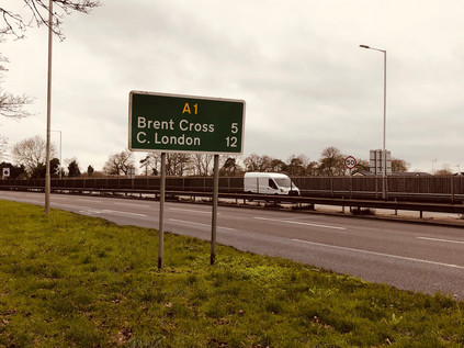
My journey out of London was the usual experience: as the interval between the suburban stations began to lengthen, more greenery crept into the window views. The sprawling city relaxed like a muscle, its margins ragged and ill-defined. I disembarked at Elstree and Borehamwood. Outside the official administrative margin, but still inside the concrete circlet of the M25 - at least, just inside... I didn't know this part of the world at all well. It was a map-smudge between Barnet and Edgware which remained unexplored, and despite being formally and spiritually in Hertfordshire, it felt perhaps more like a suburban satellite than some of the towns which had arbitrarily crept into London in the 1965 redefinition of its boundaries. While Enfield and Barnet felt like small, independent market towns which had only accidentally strayed into the city's ambit, Borehamwood felt exactly like a suburban enclave should. I navigated out of the station car park with some challenge and set off along the High Street - a haphazard grouping of national chains and local traders inhabiting a dissonant mix of 1930s shopping parades and 1990s plastic-fronted retail centres. It was busy and self-contained, and in the unexpectedly temperate January morning, not a bad place to start walking. I peeled off to the south long before the strip of shopping opportunities had ended, heading into the residential hinterlands with their mix of bungalows and modern church buildings. The road leered above me, a long straight row of tail-lamps rising ahead of me into the trees. Borehamwood ended slowly, persisting along the road out of town. Cresting the hill, I saw my route creeping in from the north to converge with my current bearings. My target today had, in fact, suggested itself a long time back, but felt like the wrong walk back then. I didn't want to be that road walking guy who endlessly recounted treks along the byways of London for their own sake. There were two considerations though: firstly, I was that road guy - a consistent string of ambulations focused on routes ancient and modern proved it. Secondly, I'd probably always been thus. My earliest memories are of lying on the living room floor puzzling out an interchange or scratchily drawing Primary Route signs after Kinneir and Calvert. But after all, who cared anyway? No-one was reading. I could walk wherever I wanted, write whatever I felt and remain largely unashamed of my preoccupations. I felt a sudden flush of freedom when I was pondering my walk on the train into London this morning. I was going to begin a new year with a new plan: five long walks along the principal A roads leading into London. All of them converged on the shifty, ill-defined 'Centre' of the city. All of them crossed the boundary at an inconvenient and distant spot somewhere in the scrubby, semi-industrial edgelands. This was just my kind of walking. At Stirling Corner, after visiting the local branch of Morrisons where sleepy Saturday-morning people appeared intent on crashing and colliding into each other with an alarming lack of care, I finally found the A1 arriving fresh from its bypassing of Borehamwood. A fire engine howled around three-quarters of the roundabout, quicker than braving the traffic lights and turning directly south. Traffic momentarily stopped and pulled aside, then ebbed back into the space it had left for the emergency vehicle as if nothing of note had happened. To the left, the road was simply signposted 'The NORTH', to the right the familiarly abbreviated 'C. London' which I always seemed to be heading towards - I crossed the busy carriageways gingerly and began walking. The next sign told me it was five miles to Brent Cross and twelve to Central London, while the clouds closed in overhead to form a grey, sound-deadening mass. Cap pulled tight and head down, I set off along the narrow footway beside the litter-strewn laybys which signalled my passage out of the Home Counties and into Greater London.
The road was broad but divided into narrow lanes which pushed the slower moving juggernauts closer to my path. I hugged the margin of bushes carefully, trying not to let my shoulder protrude in case of a stray wing-mirror. Having walked some fairly major routes around the city, this felt more precarious than any so far. The tarmac scythed through a patch of green - to the east, the public open space at Moons Moat, damp and edged by a forest of leafless, intertwined trees which presented a grim barrier against the road. To the west, a golf course - the scourge of the greenbelt - and then the M1 and London Gateway Services, formerly known as Scratchwood, after the belt of tree-covered hillside here. The services were reached by an aborted junction - a half-finished roundabout which whirled rest-area bound traffic illogically around itself before allowing them access to M&S, Starbucks and the other facilities. The M1 made a dramatic break for freedom here, curving sharply to the west and finally parting company with the railway line it had shadowed for miles out of the city. The history of the motorway and my road are inseparably linked, twin grey lines ploughing north through the lesser-valued patch of north-western suburbs which are not quite Hertfordshire, yet. Just a few days before I'd stood at the corner of Leith Street and Princes Street in Edinburgh - the start, or indeed the end of the A1 depending on your viewpoint. We'd followed its bleak and impressive beginnings south into England on our journey home, twisting into the low grey clouds which hugged the coast. It felt fitting to begin the year on this route. A band of light tinted red by the pinkish grey cloud cover broke through to the south, making the wet pavement gleam. It felt like a premature sunset. I walked towards the light...
I finally got my bearings at Apex Corner. Approaching from the south on my first visit this swirl of traffic had seemed like the end of civilisation, the A1 stretching away into the trees. Now it was a welcome return to suburbia where the road slowed and quietened somewhat, at least temporarily. I edged around the roundabout above ground rather than descending into the subways, and as a result, I witnessed the aftermath of a minor traffic incident. The police were already on scene, cars with deformed plastic fenders askance and airbags hanging flaccidly post-inflation neatly sequestered on the central reservation. I turned south, heading into the environs of Mill Hill. The land climbed to the east, into the rural edges of London which I'd skirted on the A5109 - sleepy Totteridge and the muddy slog over the fields to Whetstone lay beyond. To the west, the landscape fell away into the valley of the Dean's Brook which formed an early headstream of the Brent. The road continued south through suburban sprawl which was neither Edgware nor Mill Hill quite yet, impressive double-fronted houses and gated villas stepped up the bank, away from the road. Some of them had grand entrance stairways sweeping up to their gates, designed for impressive arrivals by equally prestigious motorcar and likely not used now that they provided access only to the litter-strewn carriageway of a shuddering, congested expressway into London. A street of shops led away west to Mill Hill Broadway station, the settlement's spiritual and commercial centre as defined by M&S Food, lying some way from the brow of the hill with its impressive views over West London. Away beyond the northbound carriageway a small knot of red brick civic buildings clustered together - the stocky, almost ecclesiastical tower of Mill Hill Fire Station glowering over the single-storey public library opposite. I continued along the route south, passing the exotic crop of domes which housed the telescopes of the UCL Observatory. Opened in 1929 the low-rise buildings were sleek, whitewashed blocks very much typical of their time, supporting the silvery domes which housed the range of telescopes, the earliest of which was manufactured in 1881 with the most recent installation just last summer. The road bisected the expansive spread of Mill Hill Park, accessed from the A1 only by a gloomy looking footpath leading to a subway linking the two segments of green space. As the road began to rise above the level of the back gardens abutting its course, I experienced the unsettling jolt of recovering a memory: I had scanned this part of the map in detail for a previous expedition. Ahead was a site of double abandonment.
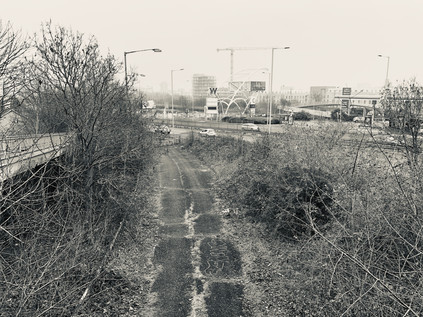
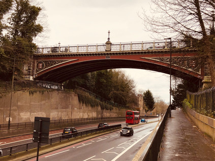
Plans to extend the Northern Line have never fared well, and the interruption posed by World War Two cancelled many of the projects in the New Works Programme which would have seen these northern suburbs better served by the underground, largely by integrating the Edgware, Highgate and London railway into the system. This railway, authorised by act of parliament in 1862, carved an ambitious and costly path into the Middlesex suburbs which were growing over the hills and valleys north of London via audacious tunnels, viaducts and embankments. It also filled a marked gap in the growing Underground map. While the former Palace Gates line is a better-known casualty of post-war austerity, now the Parkland Walk, a further scheme was also cancelled. Currently, some Northern Line trains don't make the awkward curve east towards High Barnet, continuing instead to the rather lowly single-platform terminus at Mill Hill East. Historically, High Barnet was the branch line and this, the mainline, originally reached Edgware by way of the route which passed under the A1 here. The line was near ready for conversion to Electric operation by Northern Line trains when hostilities curtailed the plan. Parts of the route still appear walkable while much has succumbed to encroaching development, but this section of the line's course survived to serve again, becoming the temporary terminus of the M1. Built piecemeal over the course of the 1970s, the route of the motorway into London was a bewilderingly challenging project, the final course of which depended on the plans for the Ringways and the complexities of squeezing a major road into the narrow channel through the hilly edges of the suburbs in which the Midland Mainline already ran. For a time while the politics and practicalities of motorways into urban London were evolving, a temporary terminus was constructed swinging traffic east to join the A1 here, just north of Fiveways Junction. Looking down on the abandoned sliproad, last officially part of the M1 in 1977 when the final section to Staples Corner opened, I was amazed to see a fairly intact road surface and mossy but extant metal crash-barriers below. In fact, the route saw a third incarnation when, following the IRA bomb at Staples Corner in 1992, it was resurfaced and pressed back into use as a terminus for the motorway once again. Maintained as a strategic priority until the early part of the 21st century, the road was now beginning to return to nature once again. A footbridge zig-zagged over the curve as it began its ascent to rejoin the A1, and at the end of the ramp I found a spot where I could scramble over a patch of wet grass to stand on the surface, exit blocked by locked barriers and huge concrete blocks, while the traffic on the A1 unsuspectingly sluiced surface-water towards me. I pondered this tiny rediscovery as I picked my way back to the footpath: my walks were often overtaken by these fragments of microhistory which, taken in isolation, seemed inconsequential. But I found a strange solace in standing on this rather heroic bit of infrastructure which had returned and returned again to serve the ever-evolving transport needs of the capital.
I negotiated the grim, clattering flyovers of Fiveways quickly but was careful to note the group of cast lions standing atop pillars around the junction. David Annand's sculptures, commissioned by the Highways Agency as a foil to the unrelenting noise and inconvenience of the frequently traffic-snarled junction, delighted in the punning title 'Civic Pride'. I ascended a bleak, narrow sliproad to join the traffic braking hard to readjust to urban conditions at the end of a higher-speed trip along the M1, my route rather suddenly changing pace too, and reverting to life as a rather quiet arterial route. Like all approaches to London, the road was flanked with large, mid-century villas which were now forlornly marooned alongside six lanes of traffic, and I trudged through a persistent drizzle along the dusty service roads which was all the separated these homes from the bursts of traffic emitted by the junction. At least the steady mizzle of precipitation kept the dust down. The road banked downhill, navigating its way into the confluence of the Dollis and Mutton Brooks below. The terrain here felt comfortably familiar - I'd previously crossed the route at Finchley Lane, and stalked the course of the Dollis Brook along the valley floor. I knew I was closing in on the North Circular near a point where the walk I'd taken there had begun to feel impossibly long and debilitating. The junction, where Great North Way folded into the North Circular as Falloden Way, was a complex entanglement of traffic signals and lane choices. Traffic approaching it fenced and jostled for position in the correct channel, space was contested and fractious. My irritability with the surroundings was rising too and I felt like I was picking up something of the road's temperament, but I resolved to stick to the tarmac and not use the path along the Mutton Brook as I had on a previous crossing of the valley. This would also allow me to get a look at the impressive frontage of the Finchley United Synagogue. Approaching the building, several things were apparent: firstly that security was very tight - yellow jackets and headsets teemed around the entrances and escorted departing worshippers to their cars. Also, the facade of the building was so impressive that I needed an angle on it. I crossed to the grassy triangle of Charter Green and turned to frame the building in my camera. The vast finned shield gleaming in the grey morning like a huge radiator, pairing with the defiantly lofty sword of La Délivrance, Guillaume's wartime sculpture purchased by Lord Rothermere and insistently sited here to enable him to see it when driving to his mother's home. The moment I clicked the button, the yellow jackets were triggered. As I turned to walk away, they shouted after me and heavy footfalls could be heard. A small group of them joined what was to be a short and low-speed pursuit as I figured that engaging was going to be the better outcome here. They caught up with me on the green and a couple passed by to ensure I was fully encircled. The leader stepped forward, a stocky but well-spoken young man bedecked with badges of authority and communications technology. "Do you know what the building is?" - I agreed I did - "So why did you take a picture of it? Can I see your camera?". I sighed - this all felt predictable and I dreaded writing of it. These challenges by extra-jurisdictional hi-vis have become all too common and are generously over-written. Anyone who dares to walk outside a set of unspoken but apparently acceptable routes will suffer such events at some point. I railed at the thought of having to describe this here, throwing myself open to derision for my hackneyed, privileged white-guy psychogeography yet again. But, however much I bristled the rule is to stay polite and firm - and I did. I first spelt out the deal - yes, they could see my camera so long as we agreed they couldn't remove it from me, handle it or attempt to delete any of the images I'd taken. Also, that despite their well-executed encirclement they had no power to hinder or detain me. A little taken aback by the well-practiced nature of the delivery I suspect, the young ringleader agreed readily - as keen to end the debacle as I. I showed them my litany of dullness: grim shots of a litter-strewn Dollis Brook, crumbling concrete stairs to nowhere, gantry signs above a rain-gleaming roadway. He looked confused but satisfied I was no risk, or at least not to the Synagogue. The yellow jackets relaxed at his relief, hands returned to pockets. They scanned the green for more pressing matters while their leader wrapped things up here. "I'm sorry sir, you'll understand why things are like this just now?". I agreed I did, and that I too was sorry that he needed to apologise for this here, now in Britain. We talked a little more - about how they'd seen protests from both the far-left and far-right, and how the temper of the debate was changing, getting edgier and more directly anti-semitic. We parted on good terms, and he returned to guard the synagogue. That last phrase is something I still find myself surprised and saddened to be writing in 2019.
Beyond this encounter the road felt muted and strange. After forking from the North Circular and curving south and east, it also seemed quieter and somewhat less important. This peeling away of traffic as the road crosses significant routes was a feature of London's radials which I'd forgotten until now. Slowly, even the greatest roads towards the City dwindle, and the A1 appeared to have lost a good deal of its strategic heft back at Henly's Corner. Now, the road hugged the valley of the Mutton Brook which wound back and forth under it, occasionally evident beneath a tangle of greenery before it disappeared into Northway Gardens. This stretch of road dated from the First World War, and was built to serve an extension to the model cul-de-sacs of Hampstead Garden Suburb which hugged the contours of Highgate Hill. Founded by Dame Henrietta Barnett who had, with her husband Samuel, also masterminded the Whitechapel Art Gallery and Toynbee Hall, the suburb took its cue from the beginnings of the Garden City movement. The suburb was to be an egalitarian enterprise, providing dwellings for all classes of person in detached houses with gardens. There were to be hedges rather than walls, and the streets would be broad and tree-lined with a much lower density than was then common, even in the suburbs. The homes to the south of the road were fine, cottage-like and attractive - and it's no wonder that the area continued to feature a number of celebrities among its freeholders. To the north of the road, the houses were a little less elaborate and more prosaic, but the magical effect of the suburb seemed to linger over them too. I wandered into the Co-op on busy Market Place and shared my concerns about the poor quality bananas with an elderly but spirited German woman who seemed less inclined than I to let this pass unremarked to the manager. Back out on the road, I ate while I walked, mindful of the time and the challenging distance ahead. I was curious to stray south towards Sir Edwin Lutyens' Central Square with its two churches and impressive school buildings, but that was for another walk. One which might equally stray along The Bishops Avenue which crossed my route nearby. Part of a cluster of streets named for Arthur Winnington-Ingram, one-time Bishop of London and prolific local landowner, this street has become an almost ludicrous proposition: sometimes regarded as the most exclusive street in London, it winds south from East Finchley towards Hampstead Heath and is lined almost entirely by mansions. The list of owners read like an unlikely collision of mid-century British culture (Katie Boyle, Sir Billy Butlin, Gracie Fields) and flat-out crooks (Emil Savundra, Asil Nadir). Nowadays, the properties are in the hands of Sultans and Saudi royals, many of them maintained only as investments in the overboiling property market which London currently provides. They still launder money through this odd little enclave, but it's all above board nowadays. On the A1 though, no such lofty denizens were found - save perhaps for an infant Jerry Springer raised in the sweeping moderne blocks of Belvedere Court - and in fact I realised that I'd seen few people walking at all, even in this relatively pleasant suburban stretch. My route was fast closing in on the old road north - a route I'd crossed and recrossed on my earlier walks through Barnet, Whetstone and Finchley - and now I met it at a dour, choked gyratory where the terraced houses ended in an abrupt demolition plot. The rest of the terrace had long since been cleared for the new road's progress exposing, the internal geometries of the chimneys to Bakers Lane. Here I turned south again, back onto the original route of the Great North Road into London.
For a brief stretch the road felt familiar - I'd blundered unexpectedly into Highgate once before when navigating between the north and south sections of the Parkland Walk, and then - as now - it was a shock of bustle and pedestrian activity. I jostled with small groups of other human beings at the street crossings, narrowly avoiding properly equipped cyclists in their expensive an unforgivingly tight kit. It's fair to say that I'd hardly strayed from relatively affluent areas of North London on this route, but this felt much more ostentatious. For a while at least, the focus shifted from the grey asphalt strip which had defined the walk to the smells of tiny delis and the chatter of young people outside stores. I was glad to be able to gaze down from the path onto the roof of the decaying surface-level railway station which had once graced the Northern Heights line. Its quiet repose beside this busy street was comforting, and the temptation to plunge into the trees and enjoy the walk along the leafy chasm left by the ghost railway was very strong. Instead, I left Highgate behind, heading south along the deepening cutting of the former turnpike built to avoid the steep hill and originally proposed as a tunnel by engineer Robert Vaizie in 1808. In 1812 the tunnel workings collapsed and it was left to John Nash, the darling of Regent's Park and its Regency terraces, to rescue the project with a brick viaduct above the deep chasm which gave the area the name Archway. Replaced with an elegant cast iron bridge carrying Hornsey Lane in 1893, the crossing still defines the landscape: as the road dipped to pass through the geological outcrop of the Northern Heights, the towers of the city were framed by the flanks of the cutting with the ornate bridge above bearing the arms of Middlesex. London shimmered through the window of the bridge, cloaked in a grey mist with a rosy cloud drifting across an attempt at an early sunset. It was hard not to be awed by the idea of blasting this culvert through the side of a mighty and ancient hill. The hazy view of London in the middle distance brought to mind the legend of Dick Whittington, turning again from these heights to return to London, taking up the office of Lord Mayor three times. The area has subsequently adopted Whittington as its genius loci with a modern hospital bearing his name climbing a substantial way along Highgate Hill. The real Whittington had a more prosaic ascent, and one not so unusual to modern audiences - having never truly been a poor man, he came to the City to turn his hand to trade and then to more lucrative money lending. He gained favour by making loans to King Richard II, and was directly installed as Lord Mayor upon the death of Adam Bamme in 1397. The Crown had previously seized the lands of the City due to misgovernment, and an early act by Whittington was to regain these lands for the huge sum of £10,000. Richard II's deposition and the subsequent reigns of Henry IV and Henry V did little to affect his good standing, and he brought surprisingly modern changes to the medieval City, including facilities for unmarried mothers and a vast public convenience known as Whittington's Longhouse. On his death his generous gifts assured him a place in the memory of London, allowing the building of a library at The Guildhall, extensive rebuilding of Newgate Prison and repair of the crumbling St. Bartholomew's Hospital.
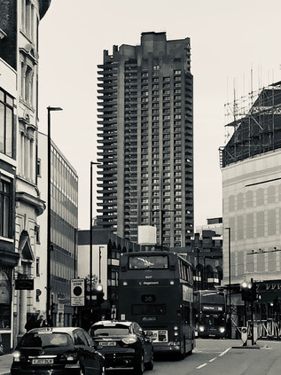
The Turnpike rejoined the old route north at the foot of Highgate Hill where a predecessor of the Whittington Hospital still broods on a corner site. The Holborn Union Infirmary opened in 1879, providing separate accommodation for Male and Female patients in an imposing yellow brick neo-gothic building with tall wings to the north and south. By 1895 the site had already been extended, a pattern which would follow throughout the twentieth century as local need grew and treatment evolved: at some point, glass verandah were added to the south-facing walls of all blocks to allow tuberculosis patients access to sunlight and fresh air. In 1944 the hospital merged with the nearby St. Mary's Hospital and Highgate Hospital to become the Archway wing of the new Whittington Hospital. It remained part of the new NHS until 1980 when functions were centralised on the current Whittington site. The building fell into decay until it was jointly purchased by UCL and the University of Middlesex in 1998 to provide a new campus for health and professional studies. Now it was again abandoned and boarded up: a Victorian imposition in the ever-modernising whirl of Archway. The forlorn, somewhat forbidding building is part future movie set, part sad hanger-on from what the locals will tell you were better times. It's harder to picture this rose-tinted past from the perspective of arrival via the A1 which was once a far less pleasant experience. Nowadays, the newly regenerated and partially gentrified Archway bustles and crackles with activity. The once dominant road network which marooned the area in the midst of a churn of impenetrable traffic has been defanged by closing a section of the gyratory. Instead, a paved market area leads through the centre of the pattern of old streets which pre-date the motor car. Outside a branch of Starbucks, a wedding party was being photographed in their finery, holding freshly brewed drinks. I must have looked askance, as an onlooker leaned over to confide "It's OK, they work there. It's where they met". I suspect I hadn't been the first disapproving passer-by in a street where pleasant, independent businesses rubbed shoulders with multinational mainstays. My last visit here had been in the early 1990s and plainly put, Archway had been a traffic-choked, grimy dump at the time. We'd played a gig at a pub more used to Country and Western acts on Junction Road, promoted by a wiry old Fields of the Nephilim fan with the unlikely moniker of 'Slim Chance'. To a country boy - Somerset via Worcestershire - the pavements had reeked of unfamiliar cuisine and the area radiated menace. It was perhaps my third trip to London, and first out of the western edges and into these cosmopolitan northern districts. Even setting aside my novice status, it was hard to see why the Archway of the late 20th century could be a nostalgic time or place for anyone who'd lived here. Not least because of the presence of the baleful gravestone of Archway Tower - a darkened tooth which seemed to overshadow their memories and anchor the zone in that era of bad politics and worse dental health.
The tower was completed in 1963 by Oscar Garry and Partners, providing seventeen storeys of office accommodation for government departments, financially advantageous by being well outside the central area, but still eminently accessible by Tube with Northern Line station in the basement. By 1967, via a process of selling-off and leasing back, it provided offices for the then Department of Health and Social Security, which remained on two floors near the top of the building until 1994, a little after our awkward gig just along the Junction Road. For almost all of its existence, it has been despised by most locals and those passing artists and musicians who often decamped here from points north on their journey towards fame or infamy. The ground around the tower swirled will ill-winds, caused by pressure differentials around the stark sides of the building, and the rite of passage of attending a dehumanising interview in the building to obtain benefits seems to have been amplified in horror by the looming fabric of the tower. As buildings go, it doesn't appear an especially terrible one - but it is perhaps hard to love because of its imposition on the low-rise suburbia around it. Archway developed slowly in the 19th century as the slums of Somers Town and Camden were cleared and railways threaded into the city, and the terraces of London Brick which gradually filled the lower flanks of Highgate Hill weren't built to bear this overshadowing behemoth, clad for much of its working life in gloomy black marble. My own memory returns as I catch sight of the glowing blue of the station sign beneath the tower: walking up Junction Road into an eddy of people and traffic, dodging beggars and drunks who were haphazardly tottering away from the tower as if repelled by its magnetism. We paused at the station entrance to meet a friend of one of our party arriving from a long trip in from Sheffield. She was late, the single working escalator disgorged endless passengers, but never her. Finally, her knitted hat peeked over the emerging steps, shoulders hunched against the city, looking small and a little terrified at the prospect of Archway being slowly revealed to her as she rose. My friend threw himself onto the filthy cigarette-strewn pavement in relief at her arrival, oblivious to the ominous dark stains creeping from the walls. Above us, with no light left to reflect from it, the building disappeared entirely into the darkening night sky. It appeared to me rather like the object on the cover of Led Zeppelin's 'Presence' - an ill-defined and inert but obviously sinister absence of a thing.
The tower lay empty for some years while rumours of demolition and gentrification competed for column inches in the local press. No-one agreed on the right course of action - and everything was unfunded and impossibly hard to accomplish while Archway was essentially a huge island in the strategic road network. The local eyesore was, however, a rallying point for the discussion about what Archway could become. In 2012 an art installation by Ruth Ewan used technology to present a live view of the Island site without the tower. It was memorialised in a booklet of reminiscences called How to Make Archway Tower Disappear which included the stories of workers from the DSS office, musicians, artists and local residents. Among them, the comments of local MP Jeremy Corbyn stand out: for him, the tower was a deliberate brutality wrought on the poor - both those employed by the state and the unemployed who plead their cases to them. He fuses form with function, seeing the Tower's rather unremarkable 1960s vernacular as an assault on an older London. A pre-welfare state London which was surely less fair and more precarious to live in perhaps? The non-committal nature of his localism stretches into the current political unravelling, and the question remains where are any of us, actually from? There's no plan in all this - just an appeal to an impossible, distant past on all sides. Apparently the most remarkable aspect of the tower was the view across London in every direction from the upper floors:
There are some nice parts of London You can see them from hereThe site was finally redeveloped and rebranded as Vantage Point in 2016 and today is clad in neutral tones, fading into the winter skies and only reflecting a little light back from carefully tinted window panes. The slab-like visage to the north and south is mute and softened by the cladding and it begs to be ignored as an unremarkable residential block. It is still, by far, the tallest building for some way around, despite competition from its contemporary 1970s neighbour, Hill House which now shimmers in mirrored glass, bouncing light onto the new pedestrian area outside the utilitarian, stocky brick Post Office. Whether it was the opposing wind channelling along the new market square or the magnetic force of the monolithic building, it was hard to escape the drag of the Tower. I briefly considered a diversion to find the site of our musical endeavours along the street, but there was too little time, and while the sky was clearing to reveal a brightness ahead, the sun was fast sinking. I wanted to reach the city in the light so I headed on towards it, passing into the edges of Holloway.Saint Etienne, 'Archway People', 1993
The Great North Road has its very origins in Holloway with a new road opened by the Bishop of London, owner of much of the land around Highgate Hill, by 1318. This safer, straighter escape from the city laid the foundations of the direct route north which survives at least as far as Archway where newer alignments take over. Much else about Holloway is unclear - and while tempting to understand its name as a rural hollow-way, worn deeply into the ground by the cattle heading for Smithfield, it is as likely to be a reference to the Hallowed Way to pilgrimage at Walsingham. In either case, modern Holloway bore little relationship to either a via sancta or an ancient cattle track. The much-improved pavements were broad and busy, carrying steady traffic from the station at Upper Holloway to the Tesco Metro and Sainsbury's Local which fronted up to the curious brick missile silo of St. Gabriel of Our Lady of Sorrows. The area fizzed with energy largely due to the presence of residential accommodation for students which is strung between the Archway Campus of Central St. Martins and the dour, overhanging concrete tower of London Metropolitan University. In the midst of this was Emirates Stadium, home to Arsenal and on any other Saturday, a little over 60,000 of their devout. Today, the team was across town, playing at West Ham's London Stadium in the midst of the Olympic Park. The eateries and pubs of Holloway were busy, but not overwhelmed and I longed to step in and rest in the increasingly fancy looking premises as I headed south and deeper into Inner London. I crossed a rubicon at Nag's Head - I'd passed through before, both on an excursion along the A503 to distant Wanstead and when I was heading back from an attempt on the North Circular. As such it felt like a boundary to a known London. A string of local businesses and familiar bookmarkers signs clustered alongside pound shops and takeaways, hugging the crossroads. It felt almost comfortingly typical - like I was home in a semi-suburban London I knew better. Beyond here, though I'd not walked much of the remaining route, I knew I was within the range of buses and trains which would get me back to somewhere near where I needed to be. My range anxiety melted away, and it became clear that it was perhaps the presence of slight frisson, a mild fear of the unknown which had kept my feet moving thus far. I felt heavy and tired, the remaining distance weighing on me as the road dwindled into a less important link between the City and the suburbs. It felt like the A1 was giving up on me, rather than the reverse. At Highbury Corner I felt myself pass through another shockwave of the nearing city - the station pulsed with activity, the population diversifying and the volume increasing. This felt like the London I'd known from my earliest visits. The darkness of Archway couldn't penetrate this far, the Tower was gone from my view now.
The pace accelerated, the city drew me in. Soon I was on Upper Street, with memories of snatched meals and happy reconvening after days spent walking. On Islington Green, Sir Hugh Myddleton stood guard, the remnants of his New River trickling underground now, streets away. Traffic careered around the junction and I realised what a destination in its own right this little corner had become. Shoppers filled the pavements, spilling into the road and precipitating attacks of honking as they blundered back onto the kerb. Despite the usually glum retail prospects for January, there were plenty of store-branded bags in evidence. Islington was fully gentrified, at odds with its radical associations and celebrated position as a centre of political influence. The seagulls, in particular, benefited hugely from the footfall, pecking at discarded scraps and strutting along the edge of the raised pavement. Since the 1960s the area has been dragging itself slowly up - terraces rejuvenated by middle-class owner-occupiers, cracked panes exchanged for CND stickers and wind-chimes on the porch. The district is home to a very specifically London kind of left-wing thought: intellectual rather than spiritual, honed in academia, hard to pin down and utterly dependent on the success of capitalism for its continued existence. This is where people voted to remain in the EU and can't for the life of them see why anyone wouldn't. This is where injustice is felt acutely and argued against loudly, but is often genuinely experienced just streets away with stoic silence. But, a kind of centrism which appals the true believers on both wings has its shameful heart on the sleeve of Islington. It's no surprise that the Blairs settled here on their journey to Downing Street. The people of Islington can win - or lose - elections for parties. These people hold the precarious balance of the Europe question, the next General Election, and probably the Bake Off final in their digits. In Britain, you always have to win the middle or lose the game. Jeremy Corbyn is duty bound to relentlessly play up his ascetic 'Good Life' credentials to continue living in the heart of the increasingly well-off, gentrifying Borough. There was, however, little sign of anti-capitalism today as Upper Street vibrated to the chirp of chip-and-pin transactions and steamed in the fragrance of chain restaurants. I pressed on, passing the Angel and crossing City Road. I was in very familiar territory now - inside the loop of the 205 bus route - but there were surprises still to be found. I'd never walked along the northern part Goswell Road - always preferring Bunhill Row or Whitecross Street to enter the City from the north with a nod to either George Gissing or William Blake. Suddenly, rearing above me like a chequerboard slab was Turnpike House. The entrance was via an elegant bow-like arch at the foot of the block, with tantalising hints of green space beyond. For the second time on this walk I thought of Saint Etienne. My appreciation of their work had begun early, with a crop of vital, life-affirmingly retrospective pop anthems which emerged in the 1990s. But we drifted apart: I found my niche in noisy low-fidelity art rock, and they strayed alarmingly into club territory. Worlds would occasionally collide in the following years with a snatched hearing of a new single or an appreciative glance at the ever glamorous Sarah Cracknell on TV, but I imagined that my London of grimy concrete and semi-industrial suburbs would never again align with their West End swagger and black-and-white movie chic. Then, almost a decade after I'd first heard them, a new side of Saint Etienne began to emerge: lyrics which read like Louis Macneice poems full of North Circular kitchen-sink drama, odes to suburbia, even a brace of films about London. The first of these Finisterre arrived in 2002, directed by Paul Kelly and scored by the band with a gritty, sometimes rather angular sounding electronic pulse. It was a hymn to the London of the early 21st century, but it drew unashamedly on the documentary films of the past, nodding knowingly at The London Nobody Knows along with the work of Patrick Keiller. The second film, What Have You Done Today, Mervyn Day? toured the site of the future Olympicopolis on those two fateful days in 2005: the announcement of the 2012 games coming to town, and the terrorist attacks on 7th July. Between these two anchors, Tales From Turnpike House was released. A gleefully London-themed pop opera of an album with a cast of almost depressingly real characters languishing, living and loving in an alienating, modern city. Bob Stanley and Pete Wiggs, unashamed Londonphiles and historians of the urban speculated that their Turnpike House would be somewhere in Croydon, on the fringe of London - but the clues were there: the architecture and alignment of the building was perfect, and The Birdman of EC1 lived in just the right postcode district.
I paused for a while here, enjoying the modern sweep of the arch under the building - a shallow portal into the greenery beyond while the grid of flats began to light up in a cryptic coded pattern as residents arrived home. The block marked the edge of the City of London, an alternative portal to replace the former Aldersgate which would have given entrance to The Barbican. Now the three concrete towers of the Chamberlain Powell and Bon designed complex: Cromwell, Lauderdale and Shakespeare, aligned across my route in silhouette against the pale red of the sunset. Their jagged shadows adumbrated on the light I'd been walking towards all day. Aldersgate, spanning the Great North Road, was recorded as early as 1395 when the Lord Mayor's sword-bearer was gifted the mansion above the gate. It was rebuilt in 1617 and repaired after the Great Fire before finally being demolished in 1761. Now the ancient way was flanked by modern, anodyne commercial facades which were dark and quiet on a weekend afternoon. It wasn't always this way, and the street has more than a hint of the supernatural about it: here the Bishops of London were housed to shorten their journey from Fulham Palace to St. Paul's Cathedral, and in 1738 John Wesley underwent his profound religious experience and conversion to Methodism as recorded in The Aldersgate Flame, a sculpture sited nearby. Naturally, not all such experiences were what they seemed and in 1554 Elizabeth Crofts, a serving girl, was hidden in the wall of a house on Aldersgate Street, her disembodied 'heavenly voice' giving dire warnings about the consequences of the marriage of Catholic Queen Mary I to Prince Phillip of Spain. A crowd of around 17,000 attended over the following day to listen before the wall was demolished and Crofts discovered as its source. This final stretch - along the former Pickax Street - was hard on the feet, but was a strangely uplifting walk: a trip I hadn't dared to think would take place had led me along a route which had been unexpectedly compelling. I trudged through the low-rise blocks of the Golden Lane Estate, and circumnavigated the brick rotunda of The Museum of London which posed as a non-descript traffic island, from some angles at least. The dome of St. Pauls was looming between the crystalline reflections of the Barbican in the fascia of Cheapside offices which hid the little church of St. Vedast. The tourists lingered, aiming for a final shot of Paul's Cross in the golden hour, the sky a fine orange band behind the stark white ashlar of the building. I didn't really know where the A1 ended - or indeed began - but it couldn't go any further than the end of New Change where it met Cannon Street. I turned the corner to mark and ending at the point where I'd contemplated the possible loss of these walks back in December, in front of the Phoenix on the south door.
After lingering in the Cathedral precincts for a while, watching tourists wrapped up in winter gear framing their perfect selfies against an unforgivingly blank sky, I summoned the effort to trudge a little further, to Ludgate Circus and a familiar old coffee stop. Resting my feet there in the quiet, surrounded by students flicking at 'phone screens and staff gossiping about other crew-members, I reflected on today's walk - and on the optimistic chance that I'd be able to continue these walks despite my concerns at the end of the year. There was much to consider - new twists in my own tale to work into the coming months - but having broken ground on a new project, one which would see walking challenging miles in sometimes inhospitably non-pedestrian zones felt good. As ever, I agonised over the rules I'd impose on myself: I'd walked the 'modern' route of the A1 after all, not the ancient Great North Road - had I already invalidated my own plans? Or perhaps that walk, through the ancient villages of Middlesex, was a different walk again. At least, for now, it felt good to be contemplating the continuation of these trips.
A gallery of images from the walk is here.
The Rust of Obscurity: An unexpected memory walk
Posted in London on Saturday 1st December 2018 at 10:12pm
After the relative return to normal service last month, things didn't look so good for today's excursion. The weather, doubtful all week, had closed in over the last day or so, leaving a high chance of heavy rain. I'd finally found time to plan some potential routes, but all of them would involve a degree of walking off-the-path, and it wasn't an encouraging prospect after a wet week. I set off intending to come up with some ideas during the journey - but even that appeared to be complicated: the incoming train to form my London-bound service was heavily delayed - an already later-than-usual arrival due to the timetable changes would be compounded by this delay. Winter walks over the years have been wildly variable, from long wet slogs to surprisingly brisk and bright treks - but I was tempted to give up right away on this one. I didn't though, for a number of reasons - mainly because I didn't know when I'd get to do this again. These monthly jaunts have become part of my routine - part of my prescription some have suggested. But due to some changes happening here, they're going to have to pause for some time. So, I couldn't abandon the last of these walks before it had begun. On arrival at Paddington, a glance out of the station wasn't edifying: a sea of umbrellas and miserable faces trudged onto the station concourse. I decided to take the Circle Line to Liverpool Street and reassess things there. With warm coffee in hand, things seemed more optimistic, so I figured I had nothing to lose and boarded a train out to Seven Kings. My reasoning was simple: on the last occasion a walk had been affected by weather, it was there I'd finally given in. If I arrived and didn't feel the same way today, I'd start walking west along the route I'd meant to follow. I'd see how far I got before the weather overcame my resolve...
The first stretch of road was the test... Disappearing into the middle-distance under a featureless grey sky, the long straight path ahead funnelled traffic between the remains of a once fairly substantial High Road and a string of development sites: new housing appearing between the road and the fan of railway sidings which led into Ilford Depot. Through the gaps in the building site I spied a Class 08 shunter sitting beside the shed, off-duty and looking incongruously old-fashioned among the modern trains. Seven Kings deferred to Ilford - the main drag relegated to second-string shops and lesser-regarded supermarkets. The arrival of Ilford proper was heralded by jagged and shiny towers of housing rising on both sides of the street, and the soaring overpass carrying the tiny but A-road classified Griggs Approach over my head. Underneath, the mercifully dry voids in the bridge were stuffed with the belongings of resident homeless people, who had set off into the damp, near-deserted streets on the eastern edge of town in search of donations. There were few to be had this morning it appeared, and Ilford was a sorry sight in the rain with only its most desperate denizens strolling unsteadily between pub and bookies. A stumbling man reeking of cider shoulder-barged me accidentally in the otherwise empty broad pedestrian plaza and then undertook to offer a sarcastically over-stated apology. He appeared to be daring me to react, to give him some sort of human response - even if it was a punch on the nose I suspect he'd have been grateful. Across the street, outside the impressive sandstone pile of Redbridge Town Hall another man knelt on the pavement, head and arms curled under him in the foetal position. Passers-by navigated between him and the metal railings like he was an inconvenient pile of animal excrement. He made no sounds and didn't react. It was a sobering and almost impossibly miserable passage through a town which otherwise appeared to have all the facilities and features of a bustling, decent-sized centre. I'd been here numerous times before, but I'd never seen this face of Ilford.
I wasn't sorry to find myself near the corner of Ilford Hill where the station entrance bustled with activity. The rain had begun to fall now and I raised the hood of my jacket, wondering if this was the beginning of the end of my walk after all? A small, Asian woman bustled by with a partly-broken umbrella adorned with the name of a small hotel in the City which my wife and I had stayed in on her first visit to the UK years ago. Already soaked, she appeared to find more effective shelter under the sliproads of the North Circular, abandoning the umbrella in the palings of a fence which shielded the River Roding from the worst litter and filth discarded from the road above. This junction was redolent with memory for me - from both my long, sore-footed trudge along the North Circular, and the dash out of a summer storm while walking along the Roding. I spotted the telephone kiosk in which I'd sheltered during that sudden cloudburst, near the footpath which led under the railway towards the Aldersbrook. For the first time perhaps, the reality of my situation settled on my mind: I'd not be doing these walks for the foreseeable future. The city would continue without me - changing wildly, yet staying stubbornly the same in other aspects - but these corners would be memory anchors during my absence. Places fixed in my mental map which had the potential to link me directly back to a moment, insignificant to most but personally formative. I realised as I regarded a damp telephone box in the rain that this was going to be a walk linking unexpected memories...
The stretch of Romford Road between Ilford and Stratford though, was new to me. I'd wondered when I set out from Brentwood on my previous attempt, whether I'd get this far along the ancient Roman route towards the Old Ford? I had assumed that Stratford might be where I ended that walk. In the event, curtailing the trek early meant I didn't have to think of a suitable ending - and I was in much the same position now. The rain had mostly stopped though the air was damp and heavy. I tentatively lowered my hood, pulled my cap on tight against the wind and strode onwards. It felt good to be walking after all the doubt and worry about the trip. The sky was a churn of grey and white, with no sign of a break in the clouds assuring that I was aware that this was a limited opportunity, a chance which could be curtailed at any turn by the weather. Entering Forest Gate, I was surprised by the continued dereliction. I'd found myself a little to the north of this spot, near the station, recently and it was generally a little tidier - there was a sense that the area was cared for and looked after to some extent. But here on the old road, it was shuttered-business-as-usual. I dodged and weaved, avoiding the deepest curbside puddles to prevent errant bus drivers from spraying me, and pushed onwards into Stratford, passing the fine brick and stone, domed buildings of the former Passmore Edwards Museum. Beginning life as the collection of the Essex Field Club, the building dates from 1900 when the West Ham Technical Institute was extended and generously decorated with Arts and Crafts style carvings representing the virtues of culture. At the same time, the complex was named for benefactor John Passmore Edwards: a newspaper magnate, Liberal politician and philanthropist who had donated generously to the cause of this and many other educational institutions. The museum bore his name until its closure in 1994. The collection was dispersed into Newham's various collections and museums - but sadly, mostly into non-public storage - and the building eventually became the Student Union for the University of East London. It is perhaps tempting to imagine what would have happened had the museum scraped into the early 21st century and been around for the Olympic regeneration of Stratford. Instead it folded during the cold storm of austerity in Local Government which drifted in with the recession. Stratford back then was painted as a grey, gloomy place which couldn't imagine a future - let alone the one it was destined to inherit. The road opened out into the Broadway, a new traffic scheme still confusing pedestrians and drivers alike. I dodged buses and cyclists, crossing the wide new plaza created between the arms of busy roads which converged on the former civic centre of the area. The focus had gradually drifted north - away from the rank of stately municipal buildings on the south side of the street to the Stratford Centre - a large regional shopping nexus built in 1974 and extended in 1998 but now dwarfed by the utterly vast Westfield complex beyond the station. Knotted into the curving service roads and stacks of concrete flats around the centre was Joan Littlewood's Theatre Royal, where the traditional brick facade seemed shockingly visible along the broad and busy mall. There was still a huge traffic of people through the complex - but the retail offer had stepped down a grade in deference to the dominance of Westfield's brand-names and braggadocio. A market struggled for much of the length of the West Mall, along which I diverted to access the facilities. As ever, I felt like everyone was walking in the opposite direction, jostling and shoving their way to early festive bargains and cheap shoes. I swerved around prams, careered into dawdling children and generally nuisanced my way through the centre, emerging opposite the station in a confusing churn of humanity. Ahead of me, a sweeping staircase funnelled people over the rust-brown iron bridge and into Westfield. Buses jostled and shunted in the newly reconfigured bus station, and people meandered across the concourse in front of the station, mostly absorbed in their screens - faces uplit by blue light in the grey afternoon. I'd been visiting Stratford for years now, watching it mutate as the station grew and changed, as Westfield arrived, as the Olympic Park dominated the landscape - and now, as it settled into its post Games status as a new eastern city centre. New buildings climbed their scaffolding cores on every horizon, the older towers of the Carpenters Estate looking small and timid against the jagged, gleaming lines of the new skyscrapers. The low-rise industrial landscape which had knitted into the brackish streams and power-lines of the Lea Valley was disappearing slowly, only stubborn and derelict outposts remaining. Stratford was a reminder that whenever I left London, it carried on without me - and would probably carry on without any of us. Driven by foreign capital and remote interests. It was possible to imagine a London without people at all, an engine of pure commerce and property speculation.
The road beyond Stratford was well-known, and I'd watched it change over the years. Beyond the familiar corner facade of The Builders Arms, appropriately the developers again held sway. The flanks of the road had been progressively cleared of their streetscape: redundant tyre dealerships swept away to be replaced by tall apartment blocks with ground-level gyms and integrated Tesco Metro stores. Up ahead, the vast sweep of industry around Sugarhouse Lane had been flattened into piles of indistinct grey pebbles and a new district was emerging slowly to fill the island site. The wooden hoardings made promises that their artists would never have to deliver on, and even a damp morning hadn't quite quelled the drifting dust from the demolition works. I crossed the Greenway finding its northern entrance closed - in fact, I couldn't remember a time when this path along the Northern Outfall Sewer had been wholly open since the announcement that the Olympics were coming to London. For a while in 2012 a temporary bridge had straddled the road here, ferrying ticket-holders from West Ham station towards the Olympic Park. Now a windswept Pelican crossing held sway, the button rarely needing to be pushed. Finding the remains of Blaker Road I turned aside and climbed down a steep flight of stairs to reach the towpath alongside the Bow Back River. I was again assailed by memory: of a walk which had confounded and intrigued me - an exploration of the contaminated zone between railway and street which had always seemed off-limits. It's fair to say, perhaps, that it was this excursion which kicked off this long trail out of London and back again. The riverside scene today was much altered, but couldn't be wholly tidied. All the new developments of Bow couldn't block out the messy, confused tangle of light industry which clung to Cook's Road for life. These backstreet bodyshops and recycling yards hadn't altered in years. They struggled on, dwarfed by towers of grey glass which were too high for residents to care much about their neighbouring ground-level eyesores since the lower floors of their flats had been given over to empty gyms and stations for bored concierges. Perhaps the collapsing sheds were marketed as a bit of real East End colour? The only hue which stood out from the dull shanty-town of workshops was regulation hi-vis green, reflected in the deeper mossy sheet of the river water. I rejoined the High Street as it approached the Bow Flyover, the shadowy missile-tower of the former Bryant and May factory dominating the horizon beyond the grimy tunnel of the A12 passing below. I'd been here just a short while ago and it felt rather comforting to be back again so soon. I realised as I passed through this well-trodden zone, far from home but curiously imbued with a sense of belonging and safety, that I'd probably not be back for a while now. It had never seemed important before, this beleaguered roadside spot nestled between an ancient church and a modern McDonalds was after all, nowhere of note. But the road stretching ahead, through the complexity and churn of the contested old East End, felt like an excursion through my own history now too. Along the broad pavements of Bow, passing the hotel when the Russian agents had overnighted with their freight of nerve agent, into Mile End where the ghost of Rachel Whiteread's house felt like it was hovering just out of sight - a silent, pale mothership which anchored the district in its own past. The demolished artwork had been hounded out by the locals, dismissed as an elitist insult. Ironically, had it survived it would likely have been the most authentic monument for miles and certainly the only one which didn't reek of old-school Victorian patriarchal philanthropy. As I entered the environs of Stepney, older roots broke ground and I recalled stalking Jewish burial grounds in the footsteps of W.G Sebald. It felt like nothing I had ever done here was novel. It's true of course that any walk in London is always in the footsteps of thousands of others, but I felt like an imposter at times - at large in someone elses fiction. It was, though, comforting to be here again - so I found a bench for an improvised lunch and watched the street unfold around me.
You might have thought, Austerlitz told me, that you had entered a fairy tale which, like life itself, had grown older with the passing of time.Austerlitz, W.G.Sebald, 2001
Underway again, Stepney merged unceremoniously into Whitechapel and I found myself following a group of women dragging wheeled suitcases, hurriedly turning from the side-street which provided access to the station while Crossrail hoardings still blocked the main entrance. They peered at a tiny map on a 'phone screen, desperately scanning the horizon for any sign of the Ibis Budget where they'd booked a night's stay for their weekend shopping trip. The crowd of market shoppers surged around them, a mess of shtreimels and burkas, the traders out-shouting each other in multiple languages. In recent times, the market felt like it had reverted to type: busy and cosmopolitan, hipsters firmly ensconced at the northern extremes of Brick Lane having given up on the unkempt and unpredictable Whitechapel end of the street. "Dont' worry - nuffink's goin' to 'appen" reassured one of the older women in the troop while the younger ones huffed and shuffled forward urgently, looking utterly terrified of the tide of diversity washing around them. They'd spent so long indoctrinating each other that now, facing the reality of London in the cold light of day, they'd begun to believe their own hype. From my vantage point I could see the distance tracker on the screen closing on their hotel, and I wondered how they'd react when they determined its proximity to the East London Mosque. Their brains could almost be heard ticking through the possibilities, all the UKIP leaflet horrors which could befall them here in this district as they hurried along muttering racism. They ploughed forward between the stalls, huddled together for fear of brushing against the alien and other. Eventually I lost track of them in the churn of the market, their desperate fearful scuttling outpacing my tired feet. I thought back to my earliest visits here, gingerly edging out of the city and into the east - each time I pressed further feeling the drag of an unseen border and then the strange twang of freedom when I passed it. I'd probably experienced a form of the same affliction - that fear of the other - not as marked or ludicrous perhaps given my upbringing in a multicultural provincial Midlands town, but nonetheless anyone who has walked in London has had the shiver of uncertainty when entering an unknown zone. It was, perhaps, what had kept me coming back all these years later.
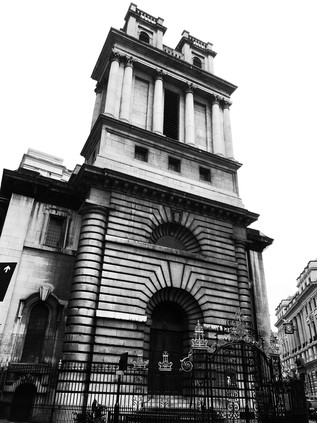
The towers of the City of London reared up at me as I arrived at Aldgate Pump - the spot which had launched an incomplete journey and a perhaps too hastily completed attempt at a book - and crossed to the centre of the road where the ancient culvert was marked. The wolf's head spout was smooth to the touch, cold but oddly dry despite the conditions. A brassy glaze had been worn to smooth metal in places, the face rubbed by curious passers-by and blasted by tiny particles of road dirt over the years. I passed the rearing gryphon on its podium, passing into the fringe of the city. When I first began to walk here, the city was closed and silent all weekend - but things were changing again. A few stores and cafés were open and busy on Fenchurch Street, the pavements surprisingly well-trodden by tourists. I navigated by instinct and memory: to Bank via Lombard Street, beside the anonymous Portland stone flank of St. Mary Woolnoth noting I remained awestruck by the reveal when turning to face the church with its overpowering bulk and unyielding starkness. It was hard to pull away from the junction and to allow myself to be swept along with a growing crowd heading away from the Bank and drawing ever closer to St. Paul's Cathedral. I could have gone so many ways here - my mental map of the city fizzing with resonances from the past. I had walked and re-walked these streets, intrigued by the city-within-a-city feel of the place and silently in awe of the antiquity of the street pattern. Today though I took a straightforward route via the southern doorway of the Cathedral. The carved phoenix still rose above the door, flanked by flames and the inscription: RESVRGAM. This often missed creature had become something of a patron spirit for me here - I continued to come back, visiting and revisiting London despite breaks, delays and events which kept me away. I rose again, walked the old pattern of city streets, pressed out further and understood more about the city with each walk. But now, it felt very much like the game was up for the foreseeable future. I waited for a large group to complete a semi-professional photo shoot with the Cathedral as a fetching backdrop, and when they moved off I slunk shyly up to the door beneath the phoenix and hoped very much it was right in its assertion. I wanted to be back here, soon.
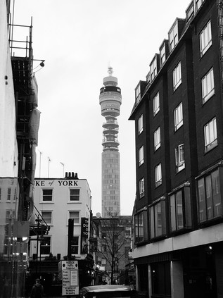
Crossing the City, I headed along Ludgate Hill noting a favoured spot where I'd watched numerous Lord Mayor's Shows, and set off up the steady climb away from the Fleet Valley. These rivers had marked my transition from a surface appreciation of the city to the beginnings of a delve under the skin. I was grateful to this waterway, hidden deep under the roadway now, for unlocking the city and pushing me eastwards into the jaws of whatever tradition I'd now found myself. Walking and writing. Sore feet and bad prose. I'd slipped into a world where I didn't belong in many ways: this city of law and money was a world away from my experience, and my ill-advised attempts to write about any of this seemed misappropriated. It wasn't mine to write and probably never had been. I felt like a fraud as I wandered up Chancery Lane for the first time in years and contemplated where I should finally end my excursion? But I wasn't ready to stop yet - pressing on westwards along Holborn and into Bloomsbury, I found the site of a much-used and fairly terrible hotel which I'd stayed at countless times when studying and exploring during the 1990s. It had reverted to an expensively appointed townhouse now, thankfully seeming to have avoided becoming offices like its neighbours. I recalled the reception: a whirl of crap and confusion, as the Australian backpacker who staffed the desk grappled with an early attempt to run an eBay business behind the counter. The sky was beginning to darken, the clouds finally dissipating and revealing a dim orange glow to the south. I realised I hadn't seen the rain in hours, and that by perhaps the oddest luck I'd stayed almost entirely dry for the whole walk. Encouraged, I set off at quite a pace again, eager to clear the environs of the British Museum where tourists were milling aimlessly around the restaurants and tat-shops lining the street, crashing into me and tutting like genuine Brits. I spotted the telephone box where I'd photographed my wife posing during her first visit to London. Memory leached from beneath every paving slab and seemed to curl from behind the street furniture. I felt unreal and disconnected from London now - moving through it but not seeing the detail anymore. Turning briefly north, the BT Tower suddenly loomed between the perpendicular facades of the street: grey tower on slate sky - only the glowing blue band of branding circulating around the futuristic nose-cone of the structure standing out from the monochrome evening which was closing in.
The final few miles of my journey passed in something of a blur: I'd walked this way in reverse around sixteen years ago, heading for the George Gissing conference at Senate House on foot. Back then it had felt like a slightly foolish undertaking, but I was accompanying a fellow delegate with a mortal fear of the Underground. As we padded west from the station along Wigmore Street contemplating the long walk ahead, I'd marvelled at this world hidden behind the retail excesses of Oxford Street. My earliest London experience had been a tentative walk out from Paddington which reached as far as Centre Point early one December morning over thirty years ago. It had seemed impossible and overwhelming, the swollen crowds of shoppers breaking like tsunamis on each road crossing and crushing dangerously around the entrances to Bond Street and Oxford Circus stations. And here, just a few yards away had been a comparative oasis. Figuring that Oxford Street would be living up to my original impressions again today I took this route again. This time though, I detoured into Welbeck Street to pay tribute to the elaborate concrete car park now threatened with demolition. Much of the architecture of this part of the West End is drab and carelessly hidden behind gaudy shopfronts, but the striking pattern of concrete shields which interlock to create this rather strange intruder is far from dull. It was though nearly impossible to get a good image: the pale concrete faded into the flat, featureless skies while passers-by nudged and hustled in their rush to get to the shops. I turned west again, towards what promised to be an unexpectedly glorious sunset despite the gloomy afternoon. A vista to the south opened as I crossed Great Cumberland Place, revealing the surprisingly tiny profile of Marble Arch offering a disappointing gateway to tourist London. I'd passed that way all those years ago in the press of the crowds and became determined to somehow understand the city beyond the facade. I wasn't sure I'd succeeded, but it had been a hell of a walk to try to find it. In the west, over the snarled traffic of Edgware Road the sky was now a swirl of orange and black. The long straight route of Watling Street led northwest in a trail of red taillights, heading out to further suburbs - some explored, some still little more than familiar names on the map. I was most definitely in the west now, as the stucco and faded grandeur of hotels around Hyde Park Square gradually ebbed into a little unknown village of bistros and bakeries near Sussex Place. After a day stuck indoors, the locals were tentatively coming out to chat and smoke at outdoor tables, wrapped up against the chilly evening. London felt benign and old here - the city of Patrick Hamilton with its myriad disappointments and hyperlocal dramas unfolding behind fogged-up windows.
I uttered a little gasp of recognition as suddenly the arc of Paddington Station's roofline appeared above the street. Without entirely intending to, I'd walked all the way back to where I'd started! Where I'd set out from this morning - but also where I'd started that tentative first walk into 'London' all that time ago. The Aberdeen Steakhouse on the corner was still trading, its illuminated sign and deep red upholstery casting a sanguine glow over the crossroads. It had all seemed so exotic back then: steak houses and bureaux de change, tiny cafés and foreign mini-markets. I hadn't guessed then that I'd see countless numbers of these little district shopping parades across the city - for me, in that moment of awestruck arrival this was London. I made my way into the station, shocked to have walked entirely across the city - it was never my intention, but it seemed fitting. This was an unravelling of memories: remediating recent excursions in the east, fading into the well-worn tracks of the city, and eventually arriving back at my point of departure in the once possibility-filled avenues of the west. I knew, as I sipped coffee and marked time above the platforms that it might be a long time before I was back here. I was tempted to capture the mundane scene in Brunel's terminus like some sort of moment of importance - but that's not my London and never has been. Instead I once again allowed the city to slip around me, watched people milling and regrouping under the glow of deceitful departure boards, studied shoppers grappling with the automatic check-outs in M&S and needing supervisors to authorise their travelling wine rations. London continued, as ever - despite all apocalyptic predictions. It will be doing the very same thing as you read this - crowds forming and dispersing, plots and dramas coalescing in greasy cafés, and very likely other over-serious would-be writers will be gazing down over station platforms, either starting or - hopefully temporarily - completing their journeys...
One thing I had learnt, the last person you should ask for a solution is the author. If he knew where he was going, he'd stop dead in his tracks.Landor's Tower, Iain Sinclair, 2002
You can find more images from the walk here.
I was still smarting a little from last month's abortive walk, but things had started tolerably well. Despite some engineering works which saw me arriving in London around half-an-hour later than usual, the journey had been relaxing and I'd read and dozed my way east. This was the first walk of winter and I'd embarked on the journey in the dark, but by the time of my arrival, there were clear skies and surprising sunshine. My coat was stashed in my bag, dreading the small chance that I'd experience a soaking like last time, but for now, it stayed rolled up and squashed into the bottom of the rucksack. I had several options on arrival - all of which would be complicated by a large number of Tube closures, but the instinct was to head out east - back into the same geography which had drenched and defeated me. I boarded a 205 bus and tried not to let its slow progress frustrate me as we lurched and weaved through the traffic on the Euston Road. Finally, we arrived at Liverpool Street and I quickly scuttled down the stairs to find the platforms closed. Somehow in my haste to get out here I'd overlooked the Overground being out of action too. I almost faltered - almost decided that this was fate and my walks in London would come to grief here: rained off and stymied by travel complications. I rallied enough to quickly head back upstairs and onto another 205. If I could get to Mile End, I could get somewhere near where I'd planned to be. It was worth a try, surely? I felt hemmed in by time and geography. This wasn't how the day was meant to begin at all...
I'd never planned to find myself alighting at the incongruously provincial Barkingside station. The pleasant little brick and stone building with its verdigris tinted cupola and hammerbeam roof didn't belong in a modern London suburb at all. The stations on this loop of the Great Eastern Railway have never been well used, being built largely as an attempt to fuel speculative developments in the Roding Valley. For a time during the First World War they closed entirely, before being handed to the emerging London Passenger Transport Board for modernisation and electrification. The programme was much delayed by wartime activity and post-war austerity, but by 1948 electric trains were running on the extended Central Line at last, including a new tunnelled section which led out east to meet the old GER line north of Ilford. Outside the station, I was in textbook Redbridge: streets of low post- and inter-war semi-detached homes stretched away from the station in grids dropped onto the topography of the valley. I headed first a little west, and then along the broad avenue of Craven Gardens, largely avoiding the surprisingly busy High Street. Since I was out here I'd decided I needed to make a pilgrimage to a notable modernist building nearby.
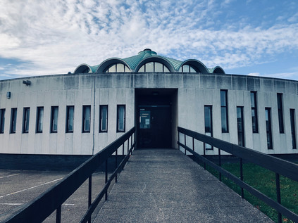
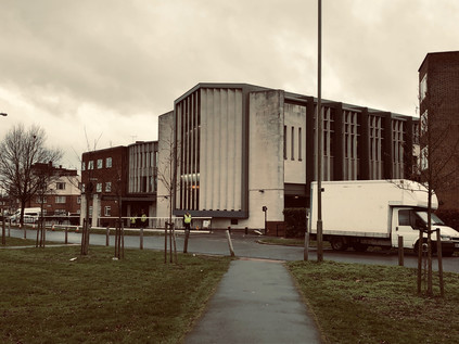
Fulwell Cross Library and Leisure Centre originated in the era of post-war reconstruction and civic recovery which produced much of the finest modern architecture in Britain. The scheme was proposed in 1958, with Frederick Gibberd - responsible for the sublime Liverpool Metropolitan Cathedral - commissioned to deliver the scheme in collaboration with the Borough Engineer, H.J Mulder. It took a decade for the plans to be realised, with the complex finally opening to the public in March 1968. Wedged into an awkward triangle of land where the busy High Street decanted traffic onto a churning traffic island, the circular library sat at the head of the peninsula. Beyond, the larger blocks of the leisure centre brooded over the construction, an empty civic square uneasily located between the two. The building was an arresting sight: like a landed spacecraft. The ramped entrance seemed forbidding at first. The ranks of tall, narrow arrow-slit like windows oscillated around the perimeter before stopping abruptly and entering a more uniform pattern which evoked either a bank vault or prison cells. Atop the whole structure, a copper-roofed lantern allowed light into the building below. I looked around: the people of Redbridge were going about their saturday morning, apparently oblivious to this strange imposition on their suburban landscape. They seemed utterly untroubled by its oddness and otherness, and clearly didn't want to borrow books today. I circled, making a complete trip around the library before retreating to attempt a picture which I knew the road would ruin. It was an exhilarating start to a trip which had seemed unlikely to deliver. Determined now to get walking, I set out eastwards along Forest Road.
The suburban edges of London soon dwindled and the footpath strayed away from the busy road and into the trees. I passed under a wooden frame which acted as a ceremonial gateway to Fairlop Waters Country Park, and soon found myself surveying a broad, rippling lake busy with boaters. The view to the east was a rising plain of green with the dark smudge of Hainault Forest on the horizon. The suburban estates on this north-eastern edge of London were an irregular patchwork with the countryside of Essex intruding into them in sometimes unexpected ways. I plotted a course to the south of the lake, passing the impressive sailing club. A couple of members were enjoying an early beer outside in the winter sunshine, marking how late I was starting out on this walk. I had no real final objective in mind now - but I was determined to make the best of the fine weather. The path plunged into a thicket of woodland via a green avenue which disappeared downhill towards the valley of the Seven Kings Water. The autumnal foliage cast a golden filter on the sunlight and I found myself relaxing into the excursion. I'd realised over the last few weeks how much these walks mattered - and when one didn't go entirely to plan, how long it seemed until the next. The path curved a little west, then passed through a gate into the yard of the Aldborough Hall Equestrian Centre. A tiny dog yammered at me from a distance and then ran indoors. I began to doubt my right to be here, but it did appear to be marked on the map as a public right of way. I pressed on and escaped via the gate at the southern end of the site, unmolested by the little but loud mutt who's yelping continued somewhere on site. My plan here had been to turn east and head for the Seven Kings Water, but it appeared that Painters Road had no footpath and was regularly used by huge quarry trucks which filled its entire width. This wasn't a pleasant prospect, so I headed south along Aldborough Road instead. This country lane passed through pleasant farmland, the hedges being tended by hand-wielded sickle as I passed by. Beside the road, a Miller and Carter Steakhouse had occupied the former Dick Turpin pub, the name restored by popular demand despite the legend having little evidence to support a local connection with this most prolific of suburbanites. The village of Aldborough Hatch provided a gentle, drawn-out introduction to civilisation. Straggling along a straight road which gradually widened into a modern thoroughfare, it centred on the fine old parish church of St. Peter which glowered over the street from behind a haphazard graveyard of tumbling memorials. This was truly one of London's villages, tracing its name back to a hæcc or 'hatch gate' to Hainault Forest which stood nearby. The lands beyond the village were subject to dramatic and destructive deforestation in 1851 which saw trees uprooted overnight and the area cleared for farmland. This led, in part to campaigns which saved Epping Forest from a similar fate, but the farming here had never been easy or productive, and these long straight lanes laid out to access the land now provided a convenient high-speed rat-run for the stone trucks and BMW drivers. The backyards of the properties along Oaks Lane were littered with hints of the rural past: unserviceable farm equipment, listed outbuildings and remains of stables and farmyards - facilities which once served the now-demolished Victorian manor of Aldborough Hall. I was thoroughly enjoying the discovery of this curious village-within-a-city when the telltale hiss and drone of a major road began to overshadow the quiet of a suburban Saturday morning. I was approaching Eastern Avenue, where I'd planned to be a whole month ago. The spell of rural Essex was broken and I was back on my more usual turf. But this charmed zone is under a more permanent threat: as I headed towards the edge of Aldborough I spotted a sign on a lamppost - Brett Tarmac, the operators of the quarry intend to drive an access road through the nature reserve through which I'd just walked. The gravel quarry had won permission to extend even closer to the village, and the new road will carry the frequent, huge trucks to and from the site. It is remarkably hard to think that this quiet little nook on the edge of London being altered for generations. I noted down the link for the petition, determined to do my little bit though doubting it would change what seemed a done deal.
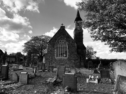
The flash of cars passing a high barrier designed to prevent pedestrians from dashing across the A12 heralded the end of Aldborough Road which decanted traffic abruptly onto the eastbound carriageway of the broad arterial route. Beside the junction, the fine jagged brick lines of the William Torbitt Primary School presented a proud face to the road. Named for the Borough of Ilford's then Director of Education, the school opened in 1937 and was designed in the art deco style by L.E.J Reynolds, the architect to the Education Committee. As my gateway to the road west, it was impressive and aspirational - modernised sympathetically so as not to alter its balanced and symmetrical face, the school echoed the municipal zeal of the interwar years. New roads and new schools to serve expanding suburbs. The optimism of the times was cemented into these good, solid buildings which ranged along this equally ambitious road. Eastern Avenue was planned in the great post-war road-building spree which saw Britain's network of ancient byways modernised and expanded to deal with the burgeoning ownership of motorcars. By 1924, the planners had settled on a sweeping modern arterial route to extend from Wanstead to Gallows Corner before taking the growing tide of holiday traffic east to Southend. The road was built to a remarkably high standard: a spacious dual-carriageway flanked by broad, separate cycleways which are now parts of the unusually generous pavement for much of the route's length. The modern A12 is a classic London arterial - running between suburban villas and parades of local shops and crossed via frequent pedestrian subways. For much of its length, Eastern Avenue is also remarkably fast-flowing, and in some stretches even falls occasionally quiet. The once pressing need to use this route out of the city has been superseded: the M11 takes traffic north into Essex and beyond, and the upgraded A13 provides a much swifter route along the Thames estuary. The mighty but groaningly overloaded M25 ferries a sluggish tide of traffic between these arms of the network while the A12 bisects the quadrant, now largely ignored except by local traffic to the suburbs. This also means it is largely unchanged from its original form, and as I began to plod west towards London, it was easy to ignore the modern developments along the route and to imagine the road as it would have been when new. I rather regretted I hadn't opted to cover the section from Gallows Corner to Aldborough when I'd last walked here, but perhaps it wouldn't have been quite so inspiring a prospect in the rain? My walk so far today had unfurled a spiral, winding out from Barkingside and now heading towards the Central Line again at Newbury Park station where I encountered another fine modern building. The bus station, built for the 1951 Festival of Britain still feels shockingly modern: a half-pipe of smooth, grey concrete with one of its elegant sides opened partially to the elements. Today, the rail closures at Liverpool Street made for lots of additional traffic as replacement bus services jostled for entrance with regular services. People milled around, unsettled by the changes to their expected journey and shaken from their usual sleepwalking journey into a weekend retail raid on town. I decided not to explore further: time was pressing, and the crush of slightly miserable, fractious travellers seemed like an unwelcome distraction. I admired the building from afar instead, trying and largely failing, to get a sensible angle for a picture. I was struck by the view through the bus station - the concrete tunnel amplified the bright blue sky beyond and the clatter and clamour of the boarding crowds. It was a fascinating and strange place which deserved another visit. Nearby, the Central Line passed under the road in a deep cutting. Once this line continued south to join the Great Eastern mainline at Seven Kings, but when the long-planned improvement works finally awoke from wartime slumbers in 1946, the tracks were slewed dramatically to the west to head into tunnels under Eastern Avenue. I peered over the bridge, briefly watching trains arrive and depart, before pressing on westwards to unravel the progress of the railway.
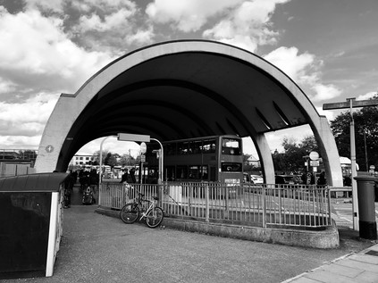
The horizon rose slightly as the road crested the shallow eastern lip of the Roding Valley. My route passed the austere and deserted Ilford War Memorial gardens which seemed to be curiously mislocated out here on the edge of the road. In fact, this was a matter of significant debate at the time of the gardens' creation in 1922, with locals seeing the site as "little more than a cabbage ground" but dignitaries assuring them that the coming of Eastern Avenue would create a great civic route into Ilford. At the extreme northeastern corner of the park, a tiny but imposing drumlike building housed the names of the dead. This Memorial Hall had followed the gardens creation in 1927, and was planned to form an entrance to the newly commissioned Emergency Wing of the Children's Hospital, though it was never used as such routinely. The symbolism was carefully balanced: from great sacrifice, new life. The hospital closed in 1993 when the modern King George Hospital opened nearby, and was finally demolished in 2001 with this tiny fragment saved for its ceremonial purpose. I stopped into a store attached to a nearby filling station and was admonished by the clerk for presenting the wrong loyalty card. I accepted his disgust as a blessing on my journey and set off again passing a ludicrously large McDonalds which I was certain must have a history. A little searching led me to The Green Gate, a pub with a long history on the site which still lends its name to this junction. Records of a beer shop here date back to 1861, but the sprawling brick building which has been appropriated by the golden arches of progress dates from a 1922 rebuild as a classic interwar roadhouse on the then-new arterial route. The internet was full of recollections of The Green Gate in its incarnation as a rock venue: the New Wave of British Heavy Metal had left a memory crater here on the fringe of Ilford which still drew a virtual crowd who had long since swapped their low-powered motorcycles for sensible family cars. Some pushed further back - Bill Haley & The Comets had played the Green Gate. Now, sticky fingers clamoured at the windows and when the door opened, the whoops and screams of over-stimulated and hyperglycaemic children pierced the drone of the road. In 2016, national newspapers had picked up the story of a late-night drive-through diner who had inexplicably Whatsapp'ed her transaction at the window, broadcasting an angry cursing employee to the world. The crossroads on these ancient routes are always sites of contention it seems. I thought of other old wayside inns I'd encountered which had suffered the same conversion: those around the North Circular in particular. It was hard to imagine Louis Macneice's autumnal progress along these routes in quite the same way when punctuated by regular calorie loading rather than flat halves of bitter, but I was glad the buildings still stood and had a modern use.
At Gants Hill, the road divided at a busy circus of local shops which concealed the Underground station. I descended into the complex of tiled subways, negotiating the junction largely by instinct as the signage was sparse and incomplete. Beyond the anonymous passageways and ticket barriers, the station is rather unique at platform level: modelled on the Moscow Metro with modern uplighters and fine tiling along the concourse between the platforms. Above ground, the A1400 struck out to the north - a spur of Eastern Avenue which carries traffic towards Woodford, and which was until the opening of the Barking Relief Road in the 1980s, part of the North Circular. It seemed fitting after my circumnavigation of those routes, to come to this historic terminal point. Today though my business lay on the A12, which lost even more traffic here, with the Woodford Spur offering easy access to the M11. I resurface on the southern side of the road, still a broad, high specification dual carriageway with pedestrian-proof barriers dividing the road - but now quieter. The view ahead opened out into the valleys of the Roding and the Lea. Pylons marched along the horizon, heading south towards the Thames. There was an autumnal haze over the landscape as I surveyed the territory I'd be walking. Eastern Avenue stretched ahead, descending gently with the terrain and reverting to type: red-brick mid-century semi-detached homes marched along the road, side roads into the suburbs largely unchanged except for a forest of satellite receivers and the imposition of 20mph speed limits. In the warm but weakening sunshine, it was possible to imagine the road as it had looked when build - wide, hopeful and expectantly stretching into a post-war future. A modern highway which extended the possibilities of a rapidly growing, modernising suburbia. It was still the age of municipal endeavour, and perhaps of paternalism in government. As the new road unrolled, so did the parks, schools and hospitals: buildings which seem so solid and inextinguishable, but which sometimes feel like they exist in only a flickering, tenuous way now. Eastern Avenue was a living, drivable museum piece. A walk into the period when war was over, perhaps forever. Where modernism was clean, sleek and decent. It was like gazing into the tubular station at Newbury Park and seeing the future.
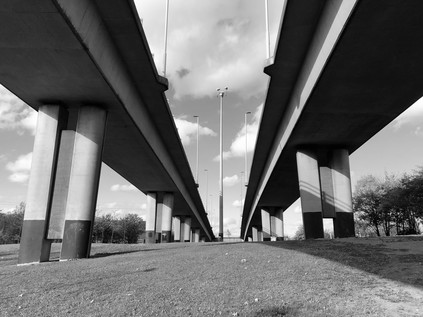
Redbridge was a jolt to the senses - a jarring sense of familiarity coupled with a sensory hit of noise and fumes. I'd arrived at this vast circle of traffic from every direction except this one and while the location checked out, things felt inverted and confused. I took the wrong turning early on, heading under the road into a tidy subway tiled in the 1970s style and surfacing near the utilitarian brick tower of the Underground station. I retraced my steps under the road and finally found a familiar spot: a parting of ways where twice before I'd ascended steps to ghost the North Circular on its approach to Ilford. Today I continued under the next arm of the road, finally finding the centre of the circus beneath the two slender viaducts carrying the divided carriageways of the A406 overhead. The road was still descending from a crossing of the Roding nearby, and still reconstituting into a single route after dividing to admit access to the M11 back at Charlie Brown's. I finally surfaced near a small development of homes which I immediately recognised from inadvertently exploring this corner when attempting to track the river. I recalled being conspicuous and out-of-place here, and the sense-memory prickle of horror at being spotted as an alien swiftly returned. I'd not seen many walkers along my route today, but this next stretch promised to be the most forbidding and least well-trodden. Turning west again along the A12 I crossed the River near Wanstead Pumping Station. The forlorn edifice, approximately gothic in appearance, glowered behind well-secured gates while the tiny brick lodge nearby lay apparently derelict. It remained home to a collection of collapsing vehicles and a fat, grey cat which greeted me gratefully at the gates and tracked me until I crossed the water. Orienting myself by the flow of the Roding I spotted my previous route along the valley floor snaking away north and now, with experience and the boldness of familiarity, I could see the way I perhaps should have taken southwards between the golf course and the river meadows and cemeteries of Aldersbrook. The terrain here had become less alien with rewalking, and seemed to offer me an easier passage. I'd earned the right to walk here perhaps?
The road snaked into Wanstead, signs warning of my impending prohibition. The tunnels into which the A12 disappeared - perhaps a little less well-engineered than was optimal - were a concession to popular opinion. The route of the A12 from Redbridge to Leyton is an official compromise, an undoing of grand plans which would have seen a very different pattern of streets here had it succeeded. The original conception dates back to the post-war plans for swift but destructive Ringways: oft-mentioned here and now largely forgotten except by enthusiastic researchers of a London which might have been. This urban motorway scheme would have seen the M11 ploughing directly into London, crossing from the Roding Valley to the Lea and channelling into a complex junction at Hackney Wick. At the same time, the A12 would have been rendered largely pointless, likely downgraded from trunk route status and with its freight of traffic funnelled away by the new urban motorways. By the late 1980s ambitious road-building was back on the agenda with the publication of Roads for Prosperity, but the Ringway scheme was dead, a victim of a long struggle to convince the public that it would represent the optimistic progress of the times during which it was conceived. Instead, the M11 would terminate at Charlie Browns', and the North Circular would ferry traffic east and south onto the newly commissioned Barking Relief Road towards Essex and the Dartford Crossing. This left a problem - getting volumes of traffic from Charlie Brown's to Central London would have been the task of the extended M11 and the short stretch of the East Cross Route which had already been built from Hackney to the Blackwall Tunnel. An improved A12 would now bear this weight instead, built to Motorway standard and scything through the tired suburbs of Wanstead and Leytonstone, widening the unnatural valley already carved by the Central Line tracks. The protests had begun in the mid-1970s when the Ringways were still an aspiration. initially, the resistance was well-mannered and institutional, following - and exhausting - all of the usual official channels over a ten-year administrative process designed likely consciously to frustrate through attrition. By 1993 direct action had been successfully deployed by protestets to prevent road projects progressing elsewhere in the UK, and now voices from outside begun to be heard around Wanstead. Initially, their ecological and largely ideological causes seemed distinct from those of the locals who were now dog-tired and resigned to change. Eventually however, the actions of a local lollipop lady named Jean Gosling, would unite them and form a resistance which was both fierce and long-lasting. The protests centred on two specific sites, one of which was nearby: the footpath became narrower and less welcoming, with cars now uncomfortably close to my shoulder, while the noise and dust compromised any hope of sensing danger. Eventually I was forced to leave via a slip-road, while the road ploughed underground ahead of me. At the top of the rise I crossed the street onto George Green. It was here where the protestors had thought an early battle was won - the new road would tunnel under the green, leaving the wide expanse of quiet, green space at the head of Wanstead High Street. It had been here for centuries, a corner of Epping Forest which had survived as part of the grounds of Wanstead House. It seemed right it should lay undisturbed. However it soon emerged that the tunnel would be built by the cut-and-cover method, necessitating the destruction and replacement of the green, and removing many well-established trees. It was one of these, a sprawling and ancient Spanish Chestnut around which the protest coalesced. When Jean Gosling learned that the tree was threatened, she drummed up support among local children and parents. Ultimately, doing so in her official uniform saw her dismissed from her job. However, the views of the incoming protestors and the locals were aligning, and when campaigners arrived for a tree-dressing ceremony and found security fences blocking their path, both camps united to tear them down in act of resistance which harked back to the earlier days of Epping Forest. The campaign was ultimately defeated by a continued heavy police presence and many allegations of intimidation and violence against the contractors and the authorities. The cost of policing the protests to save the tree spiralled to around £500,000 and a national focus on the destructive path of the M11 Link Road was assured. The Green now was quiet, backlit by the sinking winter sun with the trees casting long shadows over the path of the buried road. A distinct and bleak strip of bleached grass described the path of the tunnel. Without the shade of trees, the long, hot summer had all but burned the grass away. The ghost of the road haunted the line of proud Victorian mansions and storefronts across the street. Wanstead is a prosperous, gentrified suburb now - and the years have been kinder to it than many other inner London zones. But the sense of a sleepy suburb comes to grief at the edge of George Green where the rumble of traffic still seeps from the ground, and no amount of pretence hides the imposition on the landscape which fumes and shudders below.
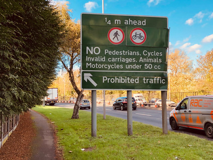
The road emerged from tunnel only briefly after passing under the Green before turning sharply and heading underground again, and there was no prospect of walking beside it. I crossed to the eastern side and followed a path which offered to take me to The Green Man. Through a metal gate, I caught a glimpse of the road below - traffic flashed by, dust churned and horns screamed as cars jostled for the correct lane at the upcoming junction. This wasn't the road I set out to walk, and any sense of loyalty to a plan or purposed had largely disappeared with the oddly dispiriting crossing of George Green. This section of the improved A12 is a 'special road' and pedestrians, horses, motorcycles and the like are consigned to other routes. I couldn't walk the route of the A12 even if I wanted to, and I'd need to take a diversion along other streets. I initially considered taking a route I'd walked before along Grove Green Road - but that didn't appeal. It would take me close to the other site of protest at Claremont Road but I had little stomach for more of the bitterness of lost campaigns today. I spotted the paths which I walked on my recent forest crossing which bisected the route of the road here and I was briefly tempted to return to Wanstead Flats. Instead I turned aside at The Green Man and headed into Leytonstone. This was, perhaps surprisingly, new territory for me. I've crossed Leytonstone's long, busy and diverse High Road many times - but this was my first opportunity to walk almost its entire length. Immediately after leaving the roundabout, a change registered. The smell of multiple cusines blended on the air: meat turned on charcoal grills while late fried breakfasts were served in traditional cafés to molify hungover stomachs, bitter coffee aromas rose over the curls of diesel smoke from delivery vehicles cocked with one wheel on the curb while fabric and 'phone cases were swiftly decanted into the long row of shops. Little had changed here in a century, but everything had changed too. The fabric of the street was the constant: shops below flats, railway bridges spanning the terraces. Meanwhile, whole populations had churned through Leytonstone, leaving their mark - and the traces of their culture - on the district. There was an air of quiet positivity here which didn't depend on any gentrifying action. While there were improvements in the pedestrian areas and much-needed places to sit and watch the world go by, there were no attempts to stage-manage the businesses. The mix of modern services, neat boutiques and older trades was dizzying and compelling. Walking the High Road was a surprising highlight of my day, and had a re-energising effect. I wanted to continue walking now - I had found my stride and beaten down the doubts and demons of my aborted mission last time.
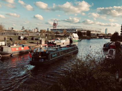
The sun was beginning to sink towards the horizon, throwing long shadows over the still busy streets of Leytonstone, and I realised I'd soon have to decide how to end my walk. It was tempting to just keep walking south, into Stratford and beyond - but practicality dictated that I start to head west at some point given the lack of transport options. At Crownfield Road I finally turned aside, heading back into the suburbs briefly. As I strode onward I found myself standing astride a small concrete marker on the footpath denoting the line of the Greenwich Meridian. Having one foot in each hemisphere felt appropriate - I was approaching the Olympic Park, a zone which felt distinctly different from the terrain I'd been crossing, and utterly alien to the East End of old. While the suburbs which splayed from Eastern Avenue were modern, aspirational and neatly zoned in their own way, they had little in common with the clumsily stage-managed new neighbourhoods which were now springing up in what was being dubbed Stratford City. I passed the entrace gates to Drapers' Fields and headed along Temple Mills Lane, crossing the complex of railway lines where Chobham Farm Junction would once have been located: the point that the Central Line had formerly joined the routes into Stratford. Despite the high security fencing and the forest of cranes sprouting from the ominously growing cores of future buildings ahead, this zone remained heavily anchored in its own history. Temple Mills was named for the large watermills owned by the Knights Templar and used, initially at least, to grind the corn grown on their extensive lands in Hackney Marsh and Leyton. This boggy, low-lying patch of the Lower Lea Valley has never been much inhabited, but has always served an ancilliary role: farming, grazing, milling. Later, the Great Eastern Railway located a carriage works on the site and the railways clung to a presence here until the very last moments before the Olympic storm settled on the East in 2012. Vast freight sidings being trimmed into a more modest wagon works and a locomotive repair depot, before finally becoming the home of off-duty Eurostar trains after their efforts on the continent each day. The other role of the vast, largely unused spaces of Hackney Marsh was storage: much could be kept out of sight here, things were easily lost on the marshes. During 1972, a strike at the Chobham Farm Container Depot saw five flying pickets jailed for contempt of court. The ensuing mishandled political fall-out contributed to the further decline of the already ailing Heath government. Tiny Temple Mills held the balance of the uneasy truce between labour and capital for just a short while. The government shouldn't have messed with Templar land: it suffered its own downfall, limping on into 1974 but dogged by industrial unrest and spiralling unemployment. Now the territory was quiet - a strip of brownfield land hugged the railway lines, waiting to be redeveloped into the new community of Chobham Manor. Beyond, the former Soviet-like blocks of the Olympic Village had been retrofitted to become homes, their lower floor retail opportunities mostly still vacant all these years later. The broad boulevards between the post-Olympic towers were in shadow in the late afternoon sun, young families arriving back from shopping or decked out in white robes, heading out to martial arts lessons. Large sections of the area still appeared unpeopled and vacant, dark windows peppering the upper floors. Ahead, the lights of the London Stadium glowed a pale blue over the tarmac. West Ham were playing at home, and as I headed deeper into the park and crossed the bridge onto the plaza surrounding the Stadium I began to feel like I was being carried along by a crowd of scarf-wearing fans. They were good-natured, perhaps friendly even - but I sensed they had me marked out as an interloper from the beginning. I peeled away towards the Lea Navigation as sirens howled and the Air Ambulance descended nearby in a swirl of dust from the compound beside of the stadium. The path around the Stadium running beside the Old River Lea was inaccessible today, so I made do with a walk along its sister canal - a veteran of so many of my walks here. It felt good to be back, crossing the bridge at White Post Lane and zig-zagging lazily onto Fish Island, dodging the oncoming tide of football fans as I fought my way south along broken pavements. Instinctively, I took a turn onto the Greenway. This meant doubling back on my route which had zig-zagged across the former marshes from Leytonstone - but that was no great hardship. I was on well-walked turf here. I knew my way.
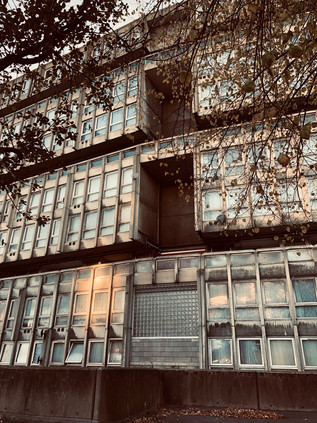
I headed back down to the towpath of the navigation where the Greenway passed overhead, its unsavoury cargo carried in huge iron pipes slung under the bridge. The taint of sewage hung cloyingly in the air, but it was good to be back on this path. This was sort of where it had begun: certainly where I'd begun to systematically edge further and further out of London. Where I'd realised that the vast, pale spread of the city on the map was a living, walkable thing. I'd resolved to walk it then - and at this natural point of reassessment I thought I'd made a pretty good job of covering the ground so far. There was, of course, ever a route untaken, always a turning unexplored. London was overwhelmed with stories, a complex mess of intersecting places which meant everything to somebody, but nothing to people just a street or two away. I picked up the pace - walking parallel to a golden sunset with the water beside me slowly darkening in the gloom. I passed under Bow Interchange on the cleverly designed floating towpath which bobbed slightly as I passed over. The path was quiet, the cold bright afternoon passing gradually towards twilight. I walked the familiar path feeling content and blessed by the opportunity. It was good to be back: passing Three Mills, crossing over the steep bridge at Bow Locks, ascending the slope beside the A12 to surface beside the Limehouse Cut. I was back on the road I'd set out alongside hours back in the comparative quiet of Aldborough. Here it was a grey gully of soot and dust. Gantry signs already vociferously diverted non-tunnel compliant traffic away from the final stretch of the A12. Or was it the A102 now? For a while this was urban motorway - one of the few segments of the Inner Ringway which ever clambered from the ambitious plans into reality. The Blackwall Tunnel Approach road clamoured and roared in a way which the A12 hadn't managed further east. It was the only way left to cross the river until the Woolwich Ferry. Drivers desperate not to be consigned to a long trip east or a diversion to Dartford bore down hard on the iron gauging rings which persuaded drivers of overlarge vehicles to think again before descending. Walking beside the road was a surprising education: the broad six-lane highway was flanked with dead businesses, defunct pubs, an abandoned Fire Station. The effect of the road out in Ilford had been cleansing and ambitious: new neighbourhoods springing from the uneasy interwar peace. Here though it was catastrophic. Blackwall and Bromley divided. Streets discontinued, and therefore ripe for future destruction. The soot-dusted trough in which the road sat was overshadowed by ill-conceived development. But then, among the glassy towers rose the concrete totem of Balfron Tower - wrapped in temporary cladding during works, only the lower rise neighbours at Carradale House reflecting the golden sunlight today. To the east, I passed the industrial edges of Aberfeldy Village. Grim and unreconstructed dead-end roads-to-knowehere disappeared among factory units, unlike the nearby development of solid and decent homes. It was almost a relief to see from the fly-tipping and junk tossed out of cab doors that some aspects of life here hadn't changed at all. The abandoned security cabins and tractor-units parked up for the weekend weren't giving away any secrets. I climbed towards the familiar intechange with the A13 behind a woman showing a newly arrived friend around the area: "There are shops up here, and a market. You can't want for much more here." The final few yards of my walk took me alongside the deep-channelled lanes of traffic which led to the Blackwall Tunnel. My attention was focused downwards, keen to glimpse the moment of transition: when cars were wholly underground. A magical disappearing act. So studious was my subterranean focus that I was shocked to look up at a still extant section of Robin Hood Gardens. The tattered edge of the stately but still curiously elegant concrete block, with some end-flats cruelly exposed to the elements, flapping in the breeze from the Thames. Just one flank remained of the vast horseshoe shaped development which had once seemed so futuristic - even perhaps hopeful? The fight for its salvation and restoration was largely orchestrated by architects and urban planning enthusiasts, and was set against a keen voice for demolition from the final residents of the complex. They had witnessed it's ultimate downfall - and heralded the loss of the one realised opportunity for Alison & Peter Smithson's 'streets in the sky' to change urban life. Robin Hood Gardens wasn't a faulty building in every sense, but it had been left to decay under the broken municipal contract. Overall though, the ambivalent voices of the debate had been tamer than the fury in Leytonstone, and both had merit. The only reprieve would be a section saved for display at the V&A - perhaps the ultimate gentrification project?
I slowly wandered over to the familiar bus circle at Blackwall, tired feed beginning to glow with the memory of a road well walked. So this was progress? I wondered as I left Robin Hood Gardens, the concrete tinted a warm pink and windows winking in the sunset, if the guardians of civic pride in little Aldborough would have thought the same?
You can find lots of pictures from the walk here. The M11 Link Road protests are extensively covered in sections of Will Ashon's 'Strange Labyrinth' (Granta, 2017) and in poetry and photography in Paul Hawkins' 'Place, Waste, Dissent' (Influx Press, 2015)
I calculated I had until about midday...
The forecast wasn't good, and as I sped eastwards under steely, unrelentingly grey skies, I doubted my calculations. I was eager to get walking too and I felt anxious to cross London swiftly, emerging on its eastern edge in a silvery gloom. The street lamps of the eastern suburbs glowed a sickly yellow, and the halos around the headlamps in the carparks sparkled in the damp air. The train out of Liverpool Street, a life-expired substitute for the new Crossrail units which were prematurely operating most services now, rattled and shuddered into the suburban stations. I was heading almost to the end of the route, and as the seats emptied I realised that the gaps between the stations were opening out, the view from the window becoming a long span of greenery beyond the rooftops. It had been a long time since I'd suffered a genuine pang of real range anxiety, and it landed unexpectedly a little after leaving Harold Wood - the edge of my walked universe in this direction, at least until now. The long stretched suburb dissolved into scrubby, green wasteland. We crossed the M25, and the emptiness continued. I felt like I'd missed the stop and been overcarried into the countryside of West Essex, but eventually the train squealed and protested into the platform at Brentwood. A few others got off beside me, but when I emerged from the gents - unlocked and free, distinctly un-London - the platform was eerily empty. A member of staff pottered along, picking litter and checking doors. I made my exit and began the climb towards the ridge on which the town rested. There was a knot of commercial activity around the station, but it soon gave way into a residential street which climbed surprisingly steeply away from the curve of the railway below. It felt good to be striding up towards the start of what promised to be a long walk towards London...
At the top of the hill I found the High Street, preserving a truly ancient alignment which pre-dated even the Roman road to Colchester. I arrived at the end of town, most of the excitement and business happening east of the junction where I joined the road. Even here though, Brentwood felt busy and provincial - not like London at all, despite the regular pulse of red buses arriving from the west. The ancient market town had always been a crossroads - the pilgrim's road to the Thames and on to Canterbury crossed the great road to the east at a point marked by a chapel dedicated to St. Thomas Becket. The town was a staging post - approximately twenty miles from London, and thus a second chance for stagecoaches leaving the city to rest at one of its many inns. It still felt like a busy place of crossing, though on a gloomy Saturday morning there was little urgency to its business. It was hard to imagine this street being the site of the very first Poll Tax Riot in 1381. I turned west and headed along London Road - the long, straight route which overlaid the old track, and which was now lined with impressive town houses and occasional business premises. The road fell away surprisingly steeply, and a sudden glimpse of the horizon stopped me abruptly. Beyond the treetops, in the far distance, I could see a blur of clustered dark towers wavering in the cloudy gloom. Above them, still darker clouds churned and rolled towards me. It was raining on London, and the city glowered under the unquiet skies. I was walking to meet the storm as it moved eastwards. I had seen London from a distance before, and experienced similar shocks at its sudden imposition on a flat landscape - but this was different. An oddly apocalyptic vision of the city from this considerable distance was both welcome in quelling my anxiety and disconcerting in its offer of inclement walking weather. I pressed on and crossed a tiny brook, only perceptible by a rusty iron balustrade beside the street. The brook, shrouded in trees, meandered west towards the Weald Brook and the Ingrebourne. I felt a little more connected to things and relaxed into my surroundings as I passed the timbered gables of Marygreen Manor - a hotel which was once indirectly connected with Henry VIII via Henry Roper, Gentleman Pursuivant to Catherine of Aragon who lived here in 1514. The road levelled as Brentwood dwindled to edgeland businesses. The pavement gave out and I stomped along a grassy verge opposite the Holiday Inn. I could feel the nexus of main roads closing on my route, the traffic slowing and a string of red taillamps providing my approach lights for the junction ahead.
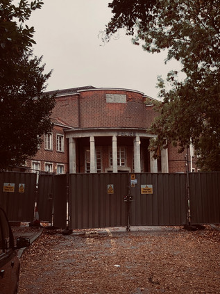
The brutality of the traffic was initially shocking - the A12 cannoned in from East Anglia, urging drivers who were glad to finally be travelling on decent, fast routes towards the more uncertain progress of the M25. The A12 continued, but it was a largely obsolete arterial which made an approach on London which few would choose willingly. Thus, once over the first rather tricky to cross southbound slip-road and under the wide concrete carriageways, I found my own exit a good deal less busy. The road ramped down towards the A12 which passed below, the footpath separated by a screen of hedges. I was walking a tightrope here: the open fields to my left were in Essex and the road to my right was in London. The situation was resolved when I finally crossed the tiny, busily trickling River Ingrebourne just where the slip-road joined the main carriageway. It turned west into the thick greenery which bordered the road, and with it, I entered the London Borough of Havering near a tired and uninviting welcome sign. It was unceremonious and undetectable unless you were looking out for it. Perhaps unsurprisingly - the gravity here was weak. A few feet further ahead, the absurd vastness of London became clearer: I was still twenty miles from Central London. The clouds rolled towards me faster than the traffic on the opposite carriageway. The cars heading out of the city had their wipers working at full-speed and dripped a trail of rainwater. I felt the first, heavy drops of late summer rain begin to plop onto the coat I'd contemplated not wearing. My charmed period of dry, sunny summer walks was ending it seemed. There was a further watery omen too: I entered the edge-suburb of Harold Wood, walking beside the road on a run of tired, mostly shuttered shops called The Parade. As I crossed Harold Court Road, a busy link heading south with a distinct slope into the Ingrebourne Valley workmen were discharging filthy waste water from a manhole, pumping it out into the road where it formed a torrent of brown effluent rushing across my path. As I gingerly stepped out, unable to entirely avoid the sheet of water cascading along the tarmac, a workman cranked the pump up a notch and the pipe sputtered a fresh gulp of dun fluid towards me. I skipped the final few steps to safety, supposing I'd at least provided them with a giggle. I wasn't staying dry though, and as I pressed onwards the final gap in the clouds sealed shut ahead of me.
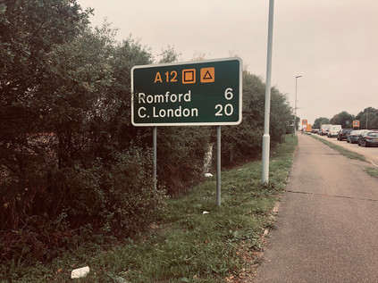
I soldiered on as best I could. The road was a headache-inducing swish and screech, and navigating across the frequent minor streets joining the main route was tricky with the oversized hood of my coat occluding the view. Harold Wood gave way to the edges of Gidea Park and I encountered another walker at last: a middle-aged man skipped out of a nearby front-garden, casually unleashing an umbrella above him. Aside from this confident moment though, he appeared out of his element. He was unnerved by the road, recoiling from the passing cars and curiously checking along every possible side-street or footpath. When a crossing was necessary or a turning opened up, it appeared to be a difficult decision for him. So erratic and confused were his actions that I worried for a while that perhaps he had dementia and shouldn't be out here alone. I stayed close enough behind to maybe help if needed, but far enough away not to spook him. Eventually, he stopped in utter confusion near a side-street and pulled out his 'phone. As I passed him, overhearing his part of an exasperated conversation, things became clearer: his car was in for repairs, and he didn't know the way to his local garage on foot. Walking had defeated him. It felt likely to defeat me too though as I got progressively more and more sodden. I paused in a bus shelter near a retail park at Gallows Corner. I contemplated bunkering in the ubiquitous chain coffee outlet nearby until the storm had passed but reasoned that this wouldn't be anytime soon. The weather had set in for the day so I could choose to walk or give up. Of course I'd walk, and as I passed the modern boundary marker denoting the course of the Roman road into London, I realised I had to make a decision: did I want to pursue the graceful but isolated and exposed arc of Eastern Avenue, or should I perhaps take a leaf from the Roman playbook here and take the shorter, straighter route to civilisation? Whichever route I took would mean navigating a segment of this unforgiving junction where the A12 and the A127 met in an unholy tangle of testy Essex-bound traffic. This spot has never been entirely quiet - even centuries back when the junction was a simple, lonely crossroads on the road to Colchester it had overlooked the gallows of the Liberty of Havering. The crossroads is the recorded burial place of numerous felons in the 16th and 17th centuries, and a jail for the condemned stood nearby on a site now occupied by a school. Nowadays, Gallows Corner was home to a chaotic circus of traffic, and since 1970 it had been spanned by a rickety and angular steel viaduct which carried through-traffic from the A12 to the A127 without the need to edge around the gyratory below. This temporary structure was notorious: driving it was far from a smooth affair, more akin to climbing steps as the bolted-together sections clanked and clambered over the roundabout below. From beneath, the much-refurbished structure looked stable enough but sounded entirely terrifying. The clatter and shudder of passing vehicles and the hissing of tyres on wet roadway sounded like the unquiet souls of the hanged protesting their fate. It was a grim spot, sandwiched between suburb and retail park, somewhere to pass through quickly and no longer designed to be visited on foot at all. I hurried onwards, my decision made - I'd take the old road from here. This was not a day to be far from civilisation.
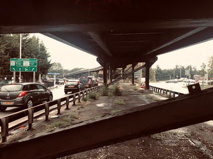
Free from the orbit of Gallows Corner, the suburb of Gidea Park stretched along the margins of the reassuringly named Main Road. The houses were spaciously spread with generous gardens and only where modern in-fill development had taken place did this feel like a traditionally cramped London suburb. Much of the development here was part of the Romford Garden Suburb, constructed around 1910 by a company formed by three Liberal members of Parliament: Herbert Raphael, Sir John Tudor Walters and Charles McCurdy. The cottages and houses were designed by competition, with many fine designs surviving as locally and Grade II listed properties which now fetch eyewatering prices at market. Later, in the 1930s the area gained a fine modern church - St. Michael and All Angels - and further modernist style homes including examples by Berthold Lubetkin's Tecton Group. My route through the suburb largely avoided these architectural gems, instead taking me along the main drag beside a parade of the normal takeaways and hairdressers but with a few more national names thrown in to convey its relative affluence. This was formerly Hare Street, a name shared by the hamlet which had once straddled the road to Romford but which had been absorbed wholesale into Gidea Park. The Great Eastern Railway arrived in 1910 at 'Squirrels Heath & Gidea Park' station - by 1913 the order of names had been swapped, and soon the current name was adopted. Hare Street and Squirrels Heath, harking back to a rural Essex past, were retired hamlets: no longer descriptive of these modern, outer suburbs on the ascent. A little further along Main Road, I encountered a notable depression with the parapets of a fine old brick bridge on each side. To the north of the road, an expanse of silvery water with a fountain spouting at its centre marked the former grounds of Gidea Hall, now known as Raphael Park. Gidea Hall enters the record around 1450 as a moated manor house in extensive grounds, but almost certainly replaced an earlier house on the same site. Rebuilt as a fine three-storey brick house by Sir John Eyles of the South Sea Company in 1720, the manor was sold to Richard Beynon who did much to improve the area, damming the brook which sprung from the grounds to create a broad pond and a watercourse later known as Black's Canal after the next owner, Alexander Black. The estate was briefly in the hands of the Land Allotment Company but was finally purchased by Herbert Raphael and gifted to Romford Urban District Council in 1904. The park remains part of a vast green stripe through the Borough of Havering, a vision which Councillor Thomas England finally realised with his own donation of land at Rise Park, making it possible to take a country walk from Romford town centre to Havering-atte-Bower in the north. Today, Havering remains the London Borough with the most green space - partly due to its enviable borderland location, but also because of the enlightened thinking of benefactors like Raphael and England during its early urbanisation.
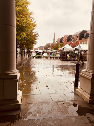
Main Road continued as an attractive, tree-lined avenue as I approached Romford. I've arrived in Romford by numerous means and in diverse directions, but it was my first arrival on foot from the northeast. Once the pleasant avenue ended, it didn't present an edifying countenance from this particular angle. The old road splayed out into the arms of a ring road at a busy, churning roundabout flanked by towers of drab housing which sprouted from the roof of a large Asda store. Ahead, a modern take on a Market Hall with a neat clocktower presented a grander gateway than I'd expected. The building was primarily a fake: offices built to mimic civic space, and access was via a gloomy sequence of subways which decanted me under the pillared entrance to the market. I sheltered awhile wondering quite what to do: I could stop here, escape the rain and find hot coffee and shelter perhaps - or just head for the station. It felt wrong to abandon this walk so early and to forfeit the precious possibilities of these trips has always been a great fear of mine. I decided to press on - my route would stick close to the railway here, so I could abort the mission at various sensible points en route if needed. Besides, crossing Romford was a diversion - the market was colourful and surprisingly buoyant despite the weather conditions. People milled around, crossing to the stalls from the decidedly 1970s vintage storefronts along the margin of the broad market street which lay on the path of the old Roman road. I compared this to my recent crossing of Bexleyheath - where old Watling Street broadened into a market square too. There were manifold differences between the zones, not least the demographic and economic contrasts, but there was a defiant quality to the market. Still here after all these years, still busy, still a place where you could get a bargain - or of course be utterly fleeced. Some traditions of old Essex haven't changed at all. I crossed the busy shopping zone of South Street, the north-south thoroughfare which I'd used to approximate the course of the River Rom when I last walked through Romford. Beyond that, my route took a turn for the drab with closed businesses and dingy, condensation-shrouded cafés lining the pavement. The whitewashed brick chimney of The Brewery towered over the decaying High Street: once the site of Ind Coope's Star Brewery - home of John Bull Bitter. The shopping and leisure centre opened on the site in 2001 and rode out the recession remarkably effectively, while the neighbouring business had fared less well it seems.
I escaped from Romford via another complex of subways which resurfaced on London Road, beside a long and rather depressing run of used car dealerships and expired pubs. I trudged on through the suburban hinterlands west of Romford, doubting my resolve to carry on and rather wishing I'd taken the easier option back at the Market Square. However, rather unexpectedly up ahead there was a change in the sky: the rolling black clouds brightened to a bruised yellow and the rain seemed to slow a little. To the north, the buildings petered out and there was open farmland to be seen. I hadn't expected this - one of the uncanny gaps in the fringe of London where it appears a bite has been taken out of the boundary. The land to the north, while peppered with quarries and golf courses, represented another unbroken run of open land which reached out beyond the final suburban edges of Collier Row into Essex. I could see traffic zipping along the A12 at the furthest extent of the field, and reasoned that had I stuck to my route I'd be slopping miserably along beside it too. I took some solace from the brightening sky and tucked my chin into my coat to walk on. A little way further ahead I passed a Coal Duty Post - the harbingers of the city which I've found repeatedly along these eastern edges. Usually they are encouraging pointers that I'm on the right track - but this one seemed to mock me. I was barely over the threshold of London. At the treacherous crossroads where Whalebone Lane crossed the road, I waited uncertainly for the lights to change. Traffic nudged and harried, drivers impatiently sounding horns and veering into others space. I crossed in a peloton of pedestrians, huddled for safety. I'd passed through Chadwell Heath before and didn't look up - there was nothing new to see, and the rain had returned with a vengeance. It was time to look for an ending which wasn't entirely a defeat. I slogged on through the retail park borderlands of Goodmayes, none the better for the drab grey sky and thorough drenching it was receiving. Every crossing of a side-road became a chore as I needed to remove my hood and get drenched again, or to crane my neck awkwardly and suffer much reduced peripheral vision. I didn't trust the impatient drivers in these conditions and it made for nervous, unpleasant progress. I noted with some surprise that I was approaching ten miles of walking since I set off from Brentwood. It didn't seem possible - I felt like I had barely begun. Then again, I was exhausted from the effort of slithering along the drenched pavements and navigating the difficult crossings. As the mile ticked over, I saw the road ahead dividing to fork around the frontage of Seven Kings station. The little red-brick building dating from 1899 was like an oasis in the desert. I accepted this opportunity as a sign: it was time to admit the road, or at least the rain, had beaten me. I trudged down to the platforms, still building sites in preparation for Crossrail's now belated coming, and fell onto a new Class 345 train which soon entered the station bound for Liverpool Street.
As I steamed and dripped my way into the city, I pondered how far my walk could have reasonably continued. Could I have made it to Stratford? Maybe even as far as the City? It was unlikely. Today had been stacked against me from the moment I saw the storm rolling west from the ridge of Brentwood, the brooding towers of the city glowering beneath it. My camera had barely left my pocket in the last hour - my progress was unrecorded. I hadn't managed to walk the broad, utopian arterial route of Eastern Avenue, nor had I quite conquered the scrappy but direct route the Roman's created toward Old Ford. I plodded from the train towards a welcome coffee when my train arrived at its terminus and figured that this walk had provided some perspective if nothing else: these trips were vitally important to me, and when they didn't work as planned I felt compromised but resolved to continue. I had unfinished business in the East once again, it seemed!
You can find a few more pictures from this wet walk here.
Lost::MikeGTN
I've had a home on the web for more years than I care to remember, and a few kind souls persuade me it's worth persisting with keeping it updated. This current incarnation of the site is centred around the blog posts which began back in 1999 as 'the daylog' and continued through my travels and tribulations during the following years.
I don't get out and about nearly as much these days, but I do try to record significant events and trips for posterity. You may also have arrived here by following the trail to my former music blog Songs Heard On Fast Trains. That content is preserved here too.
