My relationship with Kent has been a troubled one over the years. I remember deciding on a railway excursion in the mid 1990s, somewhere on the interminably dull straight line between Tonbridge and Ashford on some dirty old slam-door stock, that I was convinced I didn't like Kent at all. However, over the years as I've explored more I've begun to truly appreciate the diversity of Kent. The sheer size of the county, taking in the broad sweep of land from the English Channel to the Thames Estuary, means that my early churlish observations were of course utterly invalid when applied more widely. In particular, the stretch of coast from the Medway to the North Sea has become something of a favourite spot over the years. Times change, people change - and contrary to our hopes and wishes, places often change too. That is, in a sense, the abiding truth captured in Carol Donaldson's 'On The Marshes'.
At face value, Donaldson's book uses a long, fractured walk along the sometimes impressively bleak marshes of North Kent as an opportunity to unravel and regroup after a serious of challenging life events. Donaldson's early career, living in a caravan and cataloguing the bird population of the marshes equips her beautifully to describe the scenery and its inhabitants. Her most powerful prose is often deployed in describing the expanses of absence which are so impressive in person but so hard to conjure in words. Her love for, and connection with these places is evident in every well-chosen word. This solvitur ambulando trope is of course not entirely new, but it has so often been the preserve of men - and there are points where Donaldson is curling up in her makeshift camp on an island or sleeping in an unlocked country church where the walk - and indeed the narrative - touches on vulnerability and fear. Happily, the greatest threat to Donaldson on her walk is the daddy long-legs, her pathological fear of which rather calls into question the wisdom of devoting her early career to working for the RSPB on the marshes.
As the walk develops, more of the tale unwinds - a relationship parts ways achingly slowly: he is pulled towards the everyday, middle-class world of a career, a house, boxed-sets and takeaways while she feels rooted in the caravan on the marshes. He strays, the Thames a literal and figurative divide, while she struggles to keep her home - finally losing to the machinery of the planning process. Cut loose from people and place Donaldson retraces her steps through the marshes - and this journey becomes as much about the people who have opted out of the norm and into an unorthodox life along the muddy creeks as it is about her own experiences. Along the way, what could be an excruciating tale of self-discovery or a hymn to alternative lifestyles actually begins to grapple with a dichotomy echoed in the management of the marshes: do we want to preserve things forever as they are, unknown and untroubled, or do we want to engage with the world?
At times, there is an oversimplification in the thinking - that those who live in houseboats or tiny plotland cottages are the colourful truth while the rest of the world is a grey and unenlightened fiction - but this is generally balanced by Donaldson's self-searching and often self-deprecating rumination after meeting the cast of characters. She shows utter respect for them, and warmth and appreciation for their lifestyles and choices - but ultimately can't commit to their complete fracture from the wider world. For most of us, I suspect that this would feel the same way - and while that boat or cottage might seem utterly compelling at times of turmoil or strife, it doesn't salve the underlying issues we face. As Donaldson settles on this conclusion herself, she turns her thinking to the land which supports these unofficial communities and the politics of its management. I suspect she and I wouldn't entirely agree on this either - but her case is well-made and she writes from the rare perspective among preservationists of someone who has lived and worked on the land which she writes about.
'On The Marshes' is a strange book which sounds simple on its surface, but surprisingly challenged my thinking as I reflected on reading it. At times I was convinced I didn't like it and disagreed entirely with Donaldson's worldview and political standpoints, but by the close I was rooting for her to find her path and to write more about the landscape she knows so well. What was entirely refreshing in terms of topographical writing, was to read from the female viewpoint - to focus for a refreshing change on acceptance and belonging rather than alienation.
New Islands and Old Idols - Blackwall to Dagenham
Posted in London on Saturday 20th May 2017 at 10:05pm
The luxury of waking in London wasn't lost on me this morning. As I tramped towards an early breakfast which I took with a view over the Tower of London and bright sunlight glaring off the panels of The Shard, I pondered the day ahead and its odd division between places old and new. I've walked and written about London and its environs for years in some way, but there was a distinct tempo change in 2012 when I felt like the city was on the brink of its next seismic lurch into the future. It was a tumultuous year in many ways - in London, in the wider world and in my own life - and I noted a distinct shift in how I was thinking and writing about the city. My rambles became longer, and with them my ramblings grew too. I also began to circle further and further from the well-beaten tracks in the centre of the city. Slowly, chaotically, and in sometimes stuttering steps I grew to knew the fringes of the city which I'd previously only experienced from the windows of passing trains. When my sense of adventure failed me and I felt I'd pushed the boundaries far enough I'd scurry back to safety to scratchily write up a breathless account of my walks. For the first part of my day, I'd decided the time was right to revisit some of the locations where I'd begun to explore the edges of the city. Breakfast done I hopped onto a No.15 bound for Blackwall and followed the familiar route of the A13 out of the city and into Limehouse. There was enough cool breeze to prevent the morning from being too hot, and I wondered why I'd bothered loading my coat into my bag. A quick stop on Poplar High Street for provisions and I set off into familiar territory...
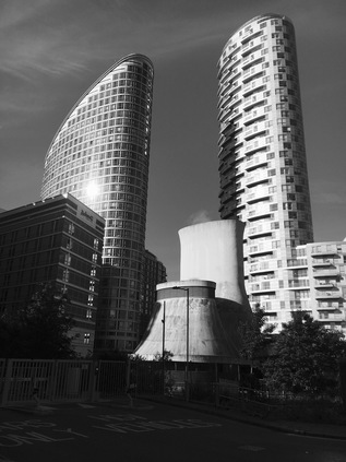
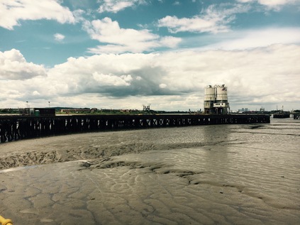
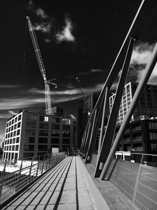
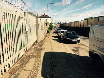
I remember lingering longer than I'd planned in Blackwall on my last visit. I'd been struck by the new city of towers rising on the fringes of Docklands, leering over the elevated DLR tracks and the angular horseshoe of Robin Hood Gardens. I hadn't expected the shift in scale between Poplar High Street and these new developments and today, with many of the cranes gone and the towers looming towards the impossibly blue sky, the effect was even more surprising. I found myself wheeling around snapping pictures of the curious views again, realising that I was probably duplicating many photographs I'd taken before. On my last visit I'd sought the river - but the aim this time was to cut across Blackwall to reach Leamouth. I was soon at the familiar roundabout at the foot of the Lower Lea Crossing - a bridge I'd seen as an impassible barrier at one time. I thought back over the many barriers I'd considered the end of London over the years, and how dark and empty the map of the East had seemed at first. Now it was rich with meaning and experience, and this felt like a gateway rather than a barrier. Today though, I didn't need to take the crossing. Slipping away beside the arc of the bridge, I headed towards Orchard Place. The urge to detour into Trinity Buoy Wharf again was strong, but there was somewhere I'd not been able to get to on my previous visit - one of the many inaccessible sections of the Lower Lea which had been, for myriad reasons, been put beyond limits for the pedestrian. Now it was, nominally at least, open again. To reach my goal though, I needed to navigate City Island - London's 'newest island' according to the glossy displays of happy, wealthy people grinning manically at each other along the wooden hoardings that still enveloped a large part of the site. In truth of course this is neither an island, nor in the city. This isthmus, one of the bulging diverticula which contort the Lea as it becomes Bow Creek, had been a place of considerable industry: glass, paraffin, plastics, naptha, tar and finally hydrogenated fats. The industries which had shadowed Orchard Place shared a couple of key characteristics - pungent fumes and lingering toxins. Now, as I tried to navigate around the entrance to the site without trangressing on some unwritten regulations which the security staff appeared to want me to obey via psychic divination, it wasn't hard to imagine the clutch of chimneys emitting a pall of darkness - the new towers rising on the peninsula stood in for them remarkably convincingly. I shuffled into the main square where the developer had, in lieu of any other stores this side of the river, set up The Grocer. What was dressed in the livery of a high-end emporium was really an expensive corner shop, with an attached but closed restaurant. A few other walkers, apparently from the blocks already completed on site, joined me as we followed the authorised route out to the western edge of the bulge in the river, following its curve towards the new bright red bridge to Canning Town. Across the water I could see the path along Silvocea Way leading to the footbridge I'd crossed before, standing beside the old iron bridge which seemed to rust even more before my eyes. I soon reached the stairs and lift leading to the tall new bridge, hanging back long enough to have the freedom to take pictures without annoying the locals. From the deck of the bridge I had a broad sweeping northern view dominated by the A13 crossing the Lea and the silhouette of Balfron Tower. Looking back towards the 'island', the knot of new buildings eclipsed the sun, the blocks unlit but bathed in a bright halo. I descended to the far bank near the rotunda leading into Canning Town station. Here I headed along the previously forbidden path on the northern bank of the river. My plan was to cross the DLR via an austere, metal-gridded footbridge and head into the industrial zone which lined the valley floor, but once over the bridge and on the descent to Wharfside Road, I noted the gate was locked at the other end. I could retrace my steps over the rails and trek around the long looping path through Bow Creek Ecology Park, or I could head out into Canning Town via the station and regain my route from there. Amused that finally accessing Orchard Place had led me to this rather pointless barrier, I headed for the station. It seems there was one sanctioned route off the island: directly to the transport interchange without looking around for fear the true nature of the river might be divined. God forbid that the new islanders found out what horrors lurked on the northern margins of their new home, or strayed east to ill-governed Rathbone Market. The island was a defensive position, surrounded by potential danger.
I carefully negotiated the complex crossings of Barking Road. Here the more recent course of the A13 thunders overhead to bypass Canning Town, while its old route continues an ancient eastern line towards the Roding Valley. The junction was a windswept and dusty spot, but I knew conditions would only get less pleasant as I continued in this direction. On the corner of Stephenson Street, much improved by a new road surface replacing the cracked and chemically melted tarmac I'd stumbled over before, was a convincing Paris Metropolitain entrance set into the wall. This curious doorway led into the location of the most recent Secret Cinema event - and it seems that somewhere in the apparently abandoned branch of Carpet Right was a recreation of Belle Epoque era Montmartre. There was no external evidence of this as I headed around the corner into the long, straight channel of filth which continued north towards West Ham, flanking the railway tracks. It was almost reassuring to see that this area hadn't changed a great deal. The Durham Arms still continued in almost invisible business on the corner behind unwashed net curtains, while the tottering stacks of old delivery crates and tractor tyres threatened collapse onto the abandoned Black Cabs and dumped cars with their locks drilled out. The same slow parade of out-of-service buses bucked along the uneven road, kicking up clouds of reeking dust from the dry surface. This area had tested my resolve on my last visit - I'd felt unwelcome and entirely beyond my comfort zone - but when I considered some of the terrain I'd blithely crossed since, I almost laughed at this bit of textbook liminal edgeland. Still, I wasn't unhappy to turn west onto Cody Road which was comparatively quiet and free of dust. I knew that Cody Dock wasn't going to provide access to the river, so instead I made my way into the surprisingly primped and tidy Prologis Business Park, passing the ever-unmanned security point with far less trepidation than before. Here, between the vast bulk of the Sainsbury's Online Fulfilment Centre and the Amazon warehouse, I found the narrow path which led to the bank of the River Lea. At the end of the path a broad arc of benches doubled as the smoking area for the warehouses, a ring of spent butts and ash encircling each seat. The views up and down the river were arresting, as new ways of looking at familiar sights often seem. With both banks largely inaccessible here, I'd only ever approximated a walk along this stretch of the river via nearby roads, and seeing Bow Locks ahead from this unusual angle was disorienting. I continued north: the path was apparently little used and crunched pleasantly beneath my boots. The path is perhaps so poorly used as it doesn't yet go anywhere useful, but slowly the links are being made. The steep but functional Twelvetrees Ramp now finally allows access from this new stretch of path onto the older route between the Lea and the Navigation without a long detour north or south along the Blackwall Tunnel Approach Road. I descended to the familiar route to Three Mills, walking between the waters with the railway bridge reflected from above. I was on well-walked and pleasantly familiar territory once again.
Three Mills Green seemed surprisingly quiet given the weather, but it was of course still early. I took a break here, picking a bench with a view north towards the gleaming steel and glass skyline of Stratford. Every time I passed through, the cluster of towers seemed to have multiplied, and the expansive view north along the Lea Valley seemed to be hemmed in by development. Set against the clear skies though, the city appeared striking and definite - a reality which I'd doubted it would ever achieve when I'd tramped over the dust of the site after the Olympics. After watching a pair of dedicated joggers circling the park for a while, determinedly avoid getting drawn into some sort of low-speed race, I headed towards Three Mills Lock. For years, the bridge here has been a boundary, First LOCOG, then Thames Water - authority has forbidden any access over the bridge and to Long Wall for around ten years. Indeed the nearby at Short Wall path was still blocked near its entrance - though it was less clear why or by whom. I'd read recently that Long Wall had opened again, and given my unusual itinerary today I decided that this missing link would be a fitting target for the first part of my walk. My heart sank at seeing notices with Thames Water insignia stationed at the entrance to the bridge - but these were in fact declaring the way open - ominously for 'the foreseeable future' at least. I crossed the bridge, looking down at the modern, concrete lock from a new angle. I wondered too when it had last opened? Built to enable a sustainable supply chain for the Olympics but never used to let a single barge into the site, the impressive control cabin still appeared to be staffed at times - the detritus of human presence clear in its high windows. At the end of the bridge the path turned a hard right to follow the eastern bank of the Prescott Channel to its confluence with the Channelsea River. Walking this bank seemed strangely defiant after being denied for all these years. The path plunged into the untamed woodland which fringes these rivers, allowing occasional glimpses towards the railway and the gasholders beyond. The Long Wall path was little more than a simple stony track under the trees skirting the former Lee Tunnel building site. It was surprising cool under the green canopy and I slowed my pace to savour this short respite from the noise and dust of London. I'd worried that this short stretch of path would be an insignificant reward for years of waiting - but it wasn't necessary. This was another fine reason to lurk in this strange, disembodied part of London. The path divided, allowing me to take a lower route, nearer to the water. Across the Channelsea was the long island which divided it from Abbey Creek, the strange derelict buildings I'd spied on the aerial photography suddenly real and present. Beyond the creek, Channelsea House rose to dominate the view, much refurbished and not as baleful and desolate as formerly. My path opened into a broad concrete platform where thick, curved iron pipes leapt from the ground to join the Northern Outfall Sewer up ahead. A well made slope took the path to join the Greenway, passing the brightly painted snail-shell turbine casing which I'd seen years ago from the bridge. I was sorry to be at the end of this new path, and almost at the end of this revisiting of the area. It was time to head for West Ham station, a short walk along the sweltering dust of the Greenway.
Given my extended day in London, I'd decided to take in another guided walk - this time based around the Industrial history of Dagenham. I've written before about my hesitation in taking guided walks and how I sometimes feel uncomfortably constrained by the idea. But based on the experience of the last trip with Rob Smith as a guide and since I'd had free rein to wander since early morning, today seemed like a good opportunity. Like Rob, the area south of the A13 on the map has been an empty white zone for me and attempts to explore have faltered on the simplest of questions: am I really allowed to be here? The dominance of the Ford Motor Works makes the boundaries hazy and amplifies the always present sense of alienation that these zones create. I'd passed through on the train, or cruised above on the road, and I was none the wiser. Hence the promise of a five mile slog via the white zone to the Thames sounded like a fine way to spend an afternoon. I made a leisurely progress to Dagenham Dock station where I found the group already assembling in the strong sunshine. It wasn't yet noon, and the threat of rain which had forced me to stuff my bag with a coat felt remote. I confess I'd never expected my excursion into the wild, filth-strewn industrial estates of Dagenham to begin with a liberal application of sunscreen, but it was certainly necessary today. Once the group was accounted for we set off, crossing the railway and pausing on the bridge to survey the extent of the Ford works, and to consider its part in the history of equal pay for skilled women workers. Though only greatly reduced activity continues on site, the breathtaking sweep of land which was once dedicated to the manufacture of motorcars was still evident in the abandoned buildings and scorched earth of newly cleared sites. The plans for this area still focus on employment and industry, but with an emphasis on green technology which will at least justify the costly remediation of this poisoned ground. Climbing down to ground level we passed under the concrete viaduct of the A13 before heading down the arrow-straight Chequers Lane towards the river. Buses reaching the end of the line on route EL2 lazily looped around at the end of the road before returning to Barking and Becontree, unsurprisingly running empty for this stretch on a quiet Saturday afternoon. We followed their dusty trail towards the junction with Choats Road, passing the end of Breach Lane. I'd hoped we'd get a glimpse of the elusive lake nestled within the gates of the Ford works, which was created by an inundation of the marshes in 1707. Unfortunately, there was no easy view to be had - but the impact of the breach on the area cropped up throughout the walk - not least in the tales of the botched efforts to restore the river wall and the eventual success of John Perry in staying the waters and removing the growing sandbank in the Thames which the breach had created, and which threatened trade in the London Docks.
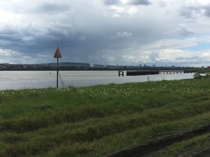
It was interesting to watch the reactions of the assembled walkers, interested Londoners and local history buffs as they progressed along the dusty, litter-strewn grid of byways between Barking Reach Power Station and the river. Some appeared to be expecting the odd, quiet desolation while others appeared eager to find any hint of nature as a relief. As we turned into Hindmans Way the road took on a more rural aspect, winding between industrial units like a country lane. Edging around the parked trucks and avoiding the thundering tractor units passing by, we turned a corner and a wide panorama of the Thames opened ahead. From Belvedere in the east to Thamesmead in the west, the south bank felt strangely close, dark clouds rolling over from the west towards us. Closer by were the gates across the jetty of Dagenham Dock which curved out across the sandbanks, rails still embedded in the ground. This felt like a forlorn and desolate place, but the presence of the sluggish, dark river was comforting. We considered Perry's work here - effectively preserving the swathe of Dagenham Marsh which the white space in the A-Z now represented. Near here in 1922, workers had unearthed a wooden anthropomorphic figurine made in about 2500 BCE, later called the Dagenham Idol - tempting though it was to think it today, we certainly weren't the first to walk here.
Unfortunately access along the Thames here is restricted by the Cemex plant and jetty, which cut across the wonderfully named Thunderer Road. This commemorates the building of HMS Thunderer at the Thames Ironworks & Shipbuilding Company, sited close by my morning walk on the Lea. The building of the Orion class Super Dreadnought, launched in 1911, nearly crippled the works as such contracts relied more on patriotic duty than fair remuneration. The works struggled on into 1912, closing after unsuccessfully petitioning War Minister Winston Churchill for more orders to save them. HMS Thunderer went on to have an undistinguished career with the Royal Navy, seeing some action in the Great War but not managing to make the impact expected of her class. The ship was decommissioned and broken up in Rosyth during 1926, attaining one last indignity by running aground on her final voyage. Technology had moved ahead swiftly and left both Thunderer and the Thames Ironworks behind. Back on the seemingly endless Choats Road, the clouds began to close in overhead. A few spits of rain were on the wind as we squeezed through a gateway to a rough public footpath which climbed up a grassy rise beside the deep gully where the Gores Brook emptied into the Thames at a sluice. I'd encountered the Gores Brook tangentially on previous walks in the area, but as much of it sat within this zone, I'd never attempted to follow it. Now it sluggishly made its last exit into the river below us, as we climbed higher onto what was once the spoil from excavating the Bakerloo Line. The area had remained largely derelict since, save for providing the early home for the Handley Page aircraft factory. Following some early and largely unsuccesful experiments in aviation which took place nearby on Dagenham Marsh becoming something of a public spectacle despite their expected secrecy, Sir Frederick Handley Page adapted the Wright Brothers original design and manufactured effective flying machines here before moving to Cricklewood in 1912, abandoning the site to become the wilderness we walked today. But this won't be wildness for long - as this is the furthest extent of Barking Riverside, the vast 11,000 home development which will occupy former industrial land and these areas of 'wasteland' between Barking Creek and the Gores Brook. As we turned the corner onto the wind-blasted green swathe which edged the Thames it was hard to imagine why anyone would want to destroy such great beauty. It was also hard to imagine living out here, nestled between the open sweep of the estuary and the broad industrial plain. Downwind of the various landfill and sewage processing areas, the air had a faint tang of metal and decay even on a breezy spring afternoon. Our group had been chatty and engaged until now, but as the scale and breadth of the view opened everyone fell silent. We were a long straggling line of walkers, making our way along this remote wild edge of things, just yards from one of the biggest industrial areas in Europe.
The path ended where another jetty cut across the riverfront, and we were forced to turn inland at the Barking Riverside Visitor Centre. This sustainable and temporary facility built from whitewashed shipping containers attempted to sell the concept of the new urban area from the very centre of the empty space it would one day occupy. An active and malleable imagination was required to see the dream today. We took the opportunity to rest around the gravelled courtyard, or to use the toilet facilities. While we waited to regroup, mostly looking silently across the river to Crossness and beyond, the storm which had rolled over South London finally broke upon the river. A squall of wind heralded a steady and hard rain. I unfurled my coat and deployed the hood for the first time, feeling justified as I waited for the rest of the group to gather and leave this exposed spot. I was rather sad to turn away from the river, having spent so much time trying to find a way to reach this area and wondering if it would be even remotely the same should I return? A gravel drive took us inland, towards the huge pale blue shed which had formed part of Barking Power Station. These last remnants of the three stations which have existed around this spot over the last century or so disgorged cables in all directions leading to clumps of transmission equipment and ranks of pylons. The idea of living among this is challenging - and it will be interesting to see how the blending of this essential infrastructure - not all of which can be easily removed - and a modern suburb will be achieved. We turned west, following River Road through the remainder of the site occupied by the former A and B power stations, including the building which heads the cable tunnel carrying power beneath the river to South London. Some of the buildings, especially the more ornate brick structures from the original 1897 station, will remain in new use - but much has already been swept away, with pristine new roads appearing on the empty site. Behind a high wire fence, bus lanes await services which have not yet been commissioned, and a new school is marooned in the midst of the empty site. Housing is springing up, but it is ill-served by transport and retail just now, and there is just the sense that Riverside will suffer the same drawn-out and painful genesis as Thamesmead or Bradley Stoke in Bristol. Making new places from scratch is always going to be a race of population versus infrastructure, and it almost impossible to imagine the right balance. I'm not sure it's quite right here at Barking, but it's equally not hitting the mark back on City Island. These are strange times to be building suburbs.
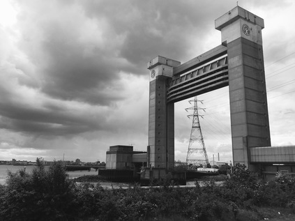
Our walk was almost at an end, and as the ominous towers of the Barking Barrier leered over the industrial units which occupied the site of the thankfully long closed guano works, we left a new place and entered a deleted zone. Creekmouth village once edged up to the banks of the river here, where the Roding and Thames meet. The villagers were supported by a range of fairly horrible work, not least skimming fat from the sewage which washed up on the beach for future use. The terrace of homes housed a small, tight village community that had its origins in the days of the Barking fishing fleet and the ice houses which allowed the boats to head further out into the North Sea, returning with still fresh fish. Creekmouth survived despite the odds, a tiny and isolated community with its own school, post office and pub, but little else. Decline began for the village in 1953 when the great North Sea flood which swept up the Thames caused untold damage to the homes. While people moved back, defiant and uncowed by the waters, the place was never the same. Families began to drift away, and now there's little to see of Creekmouth save for the Crooked Billet pub - now a premier venue for Romanian weddings - and the old school building. Around them is decay, filth and dust - the business of Dagenham moving west to occupy the unwanted land at the meeting of the rivers. We walked out to the barrier, quiet and wind-buffeted as it was on my last visit. In 1878, when the Princess Alice sank off Tripcock Ness after colliding with the Bywell Castle, many of the 650 victims were washed up on the water's edge here at Creekmouth in the following weeks, and it's hard to imagine the horror this tiny community must have suffered as a result of a tide of sewage-bloated bodies at its feet. And so, at this somewhat mournful spot where two rivers met and unimaginable suffering had occurred, our party began to disband - most of us making the walk up to the bus stop to head back to Barking. It had been a surprising and varied walk, with Rob as an excellent guide as before, and while some of the issues of accessing Dagenham's industrial zones had been demystified, there was so much to go back and research now. Perhaps it was possible to get to some of the areas I'd deemed entirely off limits after all?
As I waited for the newly-rechristened EL3 service, the rain began to fall again, steadily soaking the dusty wet pavement and kicking up a loamy petrichor to replace the stink of rotting refuse. It always seems to rain when I'm leaving Creekmouth...
A gallery of images from the Blackwall to West Ham part of the walk is here, while photographs from Dagenham and Barking are here.
I realised as I sat on the near-empty Northern Line train, shuddering noisily into the light somewhere in Finchley, that my previous visit to this part of the London had been a very long time ago. In fact my last traversal of this part of the Underground network was before I kept records of such things. In the mid-1990s I'd embarked on a project to cover as much of the Tube as I could - despite a crippling phobia regarding escalators - but this involved nothing more fastidious than marking the lines on a map. Now I was clanking into the quiet terminus at High Barnet once again, with a new project - and this time I was taking careful notes. I recalled at least that I made a dash on foot between High Barnet and New Barnet stations at some point around twenty years ago. It's perhaps no surprise that I don't remember the route in detail, but my abiding impression is of surprise at how ordinary and suburban things felt. How oddly short on spectacle things seemed, surfacing at last after delving into the earth just a few miles south in the middle of all things. I also remember that what appeared a thumbnail-width smudge of yellow between the stations on the map was in fact a fairly long walk. Outside those specially amplified 'Central Area' pages of the A-Z, scale is elusive and strange, London is elastic. I hadn't learned the over-used term 'range anxiety' then, but I felt it acutely. I need not have worried - I was imposing my ever-invasive provincial fear of 'missing the train' on a route with a far, far better service than a young man from the sticks could even imagine. My other conclusion however stands two decades later: there are just too many Barnets. High Barnet, which is - it seems interchangeably - Chipping Barnet sits high on a ridge of land in the midst of this confusion, with Barnet Gate out to the west in the Dollis Valley and East Barnet - perhaps predictably - to the east in the valley of Pymmes Brook. Between the two is the decidedly misnamed New Barnet. South of all of this, nearer to Southgate in fact, is the outpost of Friern Barnet. I can only wonder what horrors this area must have wrought on the early life of Keith Joseph who was Minister of State for Housing and Local Government at the time of the creation of new London boroughs. Despite a local committee coming up with modern, fresh and non-partisan names such as "Northgate" or "Northern Heights", Joseph - requiring as noted by The Times "the wisdom of Solomon" in this matter - opted simply to name the new entity Barnet. Keith Joseph's ideas appear to have staying power - he of course went on to play a part in the creation of Thatcherism which still exerts its peculiar influence on Britain today - and Barnet is still a rather unconvincing meta-place - an artificially constructed borough which contains many communities with competing and contesting identities. Like Barnet, Joseph was never much in the limelight, content to be the supporting act. He is, I suspect, one of the local spirits of place here.
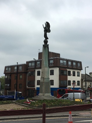
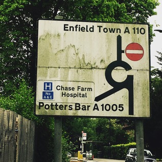
Early indications for today's excursion aren't promising - I head out of High Barnet station and immediately realise that I should have crossed the busy A1000 sooner. The footpath runs out and I'm forced to make an ungainly crossing by a glaring bus driver who seems unable to pass by and insists on allowing me to go ahead of him. I'm wearing brand new walking boots too, and while they're undeniably comfortable, I'm conscious that I'm about to walk a good distance in them for the first time. Not used to a good thickness of sole beneath me, I frequently misstep at first, bringing my left foot to a scrunching halt while the rest of me continues unabated. It's not pretty, I'm sure, for the bus full of people who just want to escape Barnet but are treated to this spectacle. As I arrive safely on the western side of the road I'm gladdened to see the view across the Dollis Valley spreading out to the west. Lush and green, punctured by red brick houses and clusters of apartments, it is also tantalisingly unwalked. This is the edge of the quadrants - London's great divide - where the rivers turn east or west away from this high ridge. A misty haze beyond Barnet indicates the edge of London - and helps to contextualise just how high up I am here. Today will literally have its ups and downs as I head east from ridge to ridge. If I'm serious about this project, then I'll need to get used to clambering up and down the valleys of the various brooks and rivers I've walked before, and potentially many I haven't. A little south of the station, as the Northern Line passes overhead on route back to the City, the object of my excursion shows up for the first time. It does so on an amateurish road sign which uses the wrong font and a frankly elephantine arrow to guide us east along the A110 for East Barnet, Cockfosters and Enfield Town. This is where my walk starts in earnest. After ceremonially popping into the local Tesco Metro which faces up across the street from the impressive Everyman Cinema at the junction, I stride off into the northern suburbs. The A110 has cropped up in several of my previous walks, and I'm curious to see how familiar it feels as it links them together. It's clear that I definitely have no abiding memory of this stretch - but it's equally plain why this feels hazy. The rank of pleasant brick villas which fringe the street is broken at intervals by the flapping white dust-sheeting which hides redevelopment. Each masked building is slowly becoming a small but luxurious block of apartments on the footprint of a former large family home. Where these new builds are complete, the pattern is clear - curving balconies fringed in bright metal bow out towards the road, and impressively secure gated entries protect the ground floor from interlopers. The street is busy with through traffic while postmen and delivery drivers weave between them making regular stops to pitch Amazon parcels into capacious letterboxes. A gentle descent begins, and I reach New Barnet which is heralded by Newbury Trent's angel of peace sculpture topping the war memorial. The junction surrounding the angel is a churn of roadworks and traffic, and I'm forced to almost completely circumnavigate the statue to get across the street. The angel, a weird mixture of classical and modern design, walks serenely to the west, her eyes forward and hands raised, holding a feather aloft. It feels strangely like she's begging to be lifted out of the chaos and fume around her. The rest of New Barnet is less modern and certainly doesn't feel new at all. In fact, considering the surrounding suburban affluence I'm a little shocked at the down-at-heel feel of some of the crumbling Victorian shop fronts which I pass after the low bridge under the line to Kings Cross. My route turns south here and begins to descend more markedly to the east. A little further on, the A110 turns left at an entirely unmarked junction to avoid East Barnet Village. I've successfully avoided East Barnet before, skirting its edge when I walked Pymmes Brook - and I soon realise with some surprise that I'm approaching the point the brook passes under the appropriately named Brookhill Road. This feeling of recognition in an otherwise strange place is a curious one - and as I wander by the closed computer shop and car hire facility which I'd vainly hoped held at least a chance of refreshments on my last walk, I realised that the delights of East Barnet Village such as they were, had been lurking just a street away. I also recalled that while last time I'd been relieved to turn south along the brook, this time I'd have to climb Cat Hill which was just as steep as I'd remembered. Again, at the junction there was little recognition of my route - except for the rather unusual inclusion of 'A110' beside the street names. I began the climb and surprised myself by not feeling exhausted within seconds. Perhaps this walking had some longer term benefits after all?
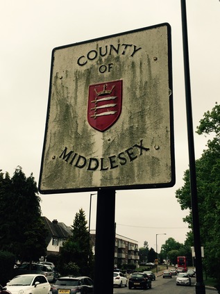
At the top of Cat Hill I stood on another ridge - this time dividing the valleys of Pymmes Brook and Salmons Brook, two minor but significant watercourse here in the north. Still a little surprised by my improved stamina, I pressed on over the ridge and onto the tongue of land which separates the valleys. Across the street, a residential cul-de-sac intriguingly called Daneland promised misty views over the falling ground south towards the distant city. With the low cloud and overcast skies it wasn't possible to see far so I pressed on, pleased to be on relatively level ground. A little way to the east, the A110 faced the most important junction I'd crossed so far, meeting the A111 at a sizeable roundabout. From here, routes reached north to the M25 and south-east towards the North Circular, with the journey onwards into Oakwood perhaps the least important of the four ways. As I navigated my way around the circle of traffic, I remembered that this junction had until relatively recently been decked out in a full set of old style pre-Worboys direction signage. My early obsession with British roadsigns had begun when these relics of a prior age of motoring were reasonably common - but sadly, now the rather ordinary modern signs simply indicated my route towards Enfield, five miles hence. There was one signage related surprise to be had though - a little before the roundabout on a pole almost obscured by trees I spotted a sign indicating I would have been passing into the County of Middlesex. The very same boundary changes which had created Barnet had done away with this ancient county which has its roots in the Saxon kingdoms which dominated the south of the British Isles. While other counties had ceded territory to the beast that was Greater London, Middlesex was swallowed entirely by it. The rise and fall I'd walked so far today was once a narrow tongue of Hertfordshire which curved south and east into what had been a proud county in its own right. As I passed into Southgate I had crossed the ancient boundary which was now barely celebrated as the border of Barnet and Enfield. The surest indication was the changed insignia on the green wheelie-bins which lurked at the end of each drive. Middlesex has all but disappeared in the mind of anyone younger than my generation - we at least had the last rites: sending our letters and pictures to children's TV studios with Middlesex postal addresses long after the county had passed into history. That said, this now erased unit of democracy has had its champions, and as I trudged by the stark, modern brick slab of the Church of Christ the King on the perhaps optimistically named Peace Close, I recalled the lines:
Dear Middlesex, dear vanished country friend, Your neighbour, London, killed you in the end.The flame of Middlesex also still burns of course in the painstaking and sometimes torturous research of Nick Papadimitriou. Nick would contend that somewhere along his endless scouring of hedges and retail parks, he has become Middlesex. I was aware of walking in his footsteps often in my northern excursions, and spotting this fragment of tangible history brought his eccentric progress around the northern heights to mind. Perhaps he was out here right now, beating the boundaries? I pressed on into Middlesex, realising I'd be passing entirely through the ghostly tail of the erased county if I managed to complete today's route.Sir John Betjeman, Marble Arch to Edgware, 1968
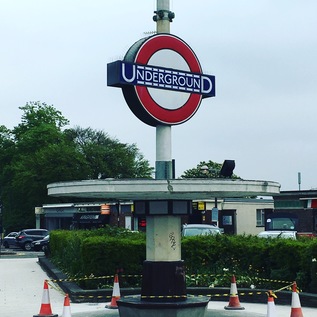
Soon after entering Middlesex I passed the imposing Oakwood Station. The huge brick and glass box designed by Charles Holden seems almost too grand for this once remote outpost on the 1933 extension of the Piccadilly Line. Serving as the line's terminus prior to Cockfosters opening some months later, the line swings north and west through a broad fan of sidings here, which extend almost all the way to the new terminus. For a while though, this fine modern station was an early battleground between the future London Boroughs which abut each other here. It's a convoluted tale - the station being initially named Enfield West despite suggestions including the frankly inflammatory East Barnet. A consolatory (Oakwood) was added to the name later, and so it stood for the next decade or so. Like many of the inter-war extensions to the Underground network the speculatively built suburbs which now surround the station followed the rails slowly, and initially Oakwood stood in isolation on unpeopled land between the two ancient municipal seats of Barnet and Enfield. The spat was finally settled in 1946 in favour of simply 'Oakwood' via the intervention of Southgate Council, who noted their claim on this area. Southgate Council was to pass into history in 1965 along with the other players in the convoluted tale of the station's name, but Oakwood remains simply that - with a tall Underground roundel pierced by a slender spike and set imposingly next to the road. Beyond Oakwood, north of the road, the health club and golf facilities at Trent Park limit the further growth of the suburbs, and after passing the station there is a surprising and uninterrupted view north into the hills of southern Hertfordshire. With the haze beginning to lift the broad sweep of southern England was oddly breathtaking and a remarkable contrast to the suburbs I'd been plodding through. Tempted by the various cafés which lined up alongside the station and its parade of shops, I managed to continue east. With the A110 forming the northern boundary to the suburbs here, I was keen to cross the street and walk on the rural side of the road. I was rewarded with unexpected flashes of green hills and distant woods peeking between the trees and scattered farm buildings. I noted though that there were frequent warnings that this was Private Land which seemed oddly unnecessary. My curiosity was answered a little further ahead by a neat banner hung on a gate to promote Enfield Road Watch. It seems this green fringe is under threat from development. It's easy to see why the locals would want to protect this zone - and equally hard to imagine what more attractive place a speculative developer could find for their new urban extensions than this Underground connected semi-rural haven. Perhaps the modern builders will finish the job begun between the wars - but I hope the locals prevail, just for a little longer at least.
The straight road ahead of me began to delve down into another valley and I could see the higher ground of Enfield Town rising away in the distance, church towers and impressive houses flanking my route ahead. The ridge I'd been walking since East Barnet tapered down into the the catchment of Salmons Brook, bottoming out at World's End where I'd begun my walk along the waterway last winter. I knew this meant a long slow climb up Slades Hill on the other bank of the stream, which I wasn't looking forward to - so I rested a while near the brook, watching traffic zipping down the rollercoaster created by the valley bottom. Eventually I set off again, taking the steady climb again surprisingly in my stride, slowly progressing through the ranks of imposing homes on the outskirts of town. Enfield is a curious place with its own onion-skin layers of development emanating from a busy centre. Once at the top of Slades Hill, the Ridgeway swings north to head out to Potters Bar, and my route gently slopes into town via a long terrace of shops caught in mid gentrification - the ubiquitous Ladbrookes standing next to quaint little organic eateries and just across the street from a Waitrose. There's a pleasant buzz to the slowly emerging town as I cross the idyllic loop of the New River with ducklings skittering around behind their mother, and pass under the railway near Enfield Chase station. I take a moment to pause for coffee in the busy high street near a somewhat upscale street market selling artisanal foodstuffs, probably a world away from the business conducted in the square for centuries before. I notice too that the installation of Britain's first cashpoint is market with a small blue plaque too - and I can imagine based on trade today that it was well used. My last visit to Enfield was early in the morning when the meeting of ways centred on the war memorial was almost entirely deserted - but today the pavement is wedged with shoppers and I'm glad to finally strike out east again, beside the restored and pleasantly reedy old course of the New River towards Southbury. The town gives way to straggling suburbia as the New River turns north to regain its main route, this last stretch not yet restored and little more than a reeking green ditch between ranks of decaying metal siding. There is a haze of traffic in the middle distance as the road approaches the crossing of the A10 - the Great Cambridge Road. A huge leisure complex looms on the northern flank of the carriageway, the building silvery and impenetrable - unless one pays the requisite fees of course - but offering all the refreshment and entertainment you'd need within. The self-contained pleasure centre is served by its own footbridge too, meaning that access can be gained without taking your chances on the busy road crossing - they want to be certain your wallet arrives in one piece of coure. Those of us wanting to pass over the A10 however have to navigate a complex of traffic signals which interrupt six lanes of growling, shuddering vehicles rudely brought to a stand at a red light. It's an uncomfortable intrusion into my walk, which while it has passed along busy streets, hasn't encountered a main arterial like this at all so far. I've been aware of but shielded from London on this cross-route it seems, and here I'm crossing one of its primary gateways - bored motorists gunning their engines waiting either to enter or escape the gravity of the city. I'm an irritation. Why would you walk out here? I'm glad to be over the boundary which the road creates and entering the familiar edgeland scenery of Southbury - vast supermarkets, retail hangars and distant tower blocks. I can feel the magnetic pull of the Lea Valley beyond. This is more my usual kind of place, it seems.
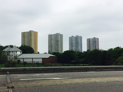
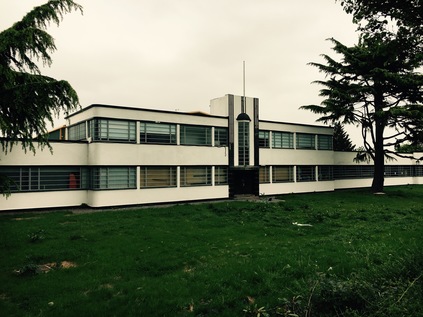
The change in zones is tangible - and almost jarring. At the hump in the road where it heaves over the line to Liverpool Street is the tiny, Victorian red-brick Southbury station, marooned atop the bridge and crowded in by two solid and miserable new-build cubes. The road falls gently away ahead of me as the solid brick terraces of Ponders End close in. Looking to the horizon, a band of green indicates Epping Forest climbing away from me to the east. I try not to feel too elated to see my goal - the land between here and the forest is flat and deceptive, and I'm really only just over half way along my planned route. This long, flat passage into the Lea Valley is oddly tiring. The roadside scenery has been a constant band of retail unit grey for some way, and the dusty carriageway is plagued by too much traffic going far too fast, making the dodge across the valley here to avoid the sluggish progress around the North Circular. Opposite the station is a curious survival - the art deco Ripaults cable factory - a smooth, aerodynamic gem of the type of building which seems to crop up more readily along the western arterials out of the city than here in the east. Now in the care of builders' merchant Travis Perkins, the paintwork is pristine and the building remarkably well-kept. Almost too clean in these dirty, dusty surroundings. The listing of the building clearly helps. Looking around I'm reoriented by the appearance of four dominant tower blocks. I've seen these huge buildings before from the other side of the valley - built to an entirely different scale to the surrounding low-rise light industrial landscape. Curlew, Merlin, Cormorant, Kestrel - the four guardians of Ponders End line up attractively for a gloomy cross river shot, but close up they are more human in appearance if no less impressively massive. Practical, unadorned and straight-sided, their only concession to decor are the coloured panels which run down each block, distinguishing it from its siblings. The alignment from close quarters is tighter and the blocks feel huddled for safety here, rather than the overbearing aspect they posses from the east bank of the Lea. I snap shots from a few angles, enjoying the way the scene changes as I gain ground on the blocks, then slip by them. Suddenly, I'm at a roundabout near Wright's Flour Mill, the old industrial buildings oddly out of scale with their modern surroundings. The signs here encourage walkers and cyclists to head down to the footpath on the Lea Navigation, but I'm determined to stick to my plan - however uninviting the bridge over the river has been made. After negotiating a road sign planted inconveniently in mid-path, I find myself on a narrow pedestrian refuge inside the crash barrier. Ahead of me, the green of the valley sprawls north and south, the ubiquitous pylons ranging left and right. Below, the first branch of the navigation is calm as it winds around a broad meadow in front of a Harvester restaurant named for it. I recall this spot from a previous walk along the river - where the way splits and a substantial loop of water disappears behind the riverside inn. Further to the east I can look back and see the view from a new angle, marvelling at the complexity of the watercourses in the valley. A little further ahead the expansive valley view is gone, and the road enters a deep green chasm between the huge reservoirs. Sheep graze on the banks investing only cursory interest in the solitary walker on this causeway, and seeming to be entirely untroubled by passing vehicles. I almost a little oppressed by the presence of the vast bodies of water above me on both sides. I also feel strangely and conspicuously alone, despite the regular pulse of traffic on the road. The valley never ceases to find new ways to feel strange and unnerving - perhaps one of the reasons I'm drawn back here again and again.
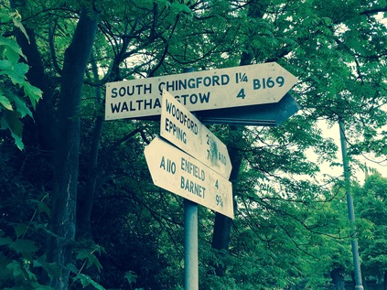
As the reservoir banks taper down to ground level at a knot of complex water-related buildings and pipeworks, I cross the final channel in the tangled web which the Lea weaves along the valley. In doing so I leave the traditional County of Middlesex behind and enter Essex. Except of course I don't - in the post-1965 scheme of things this is Waltham Forest. More accurately it is the foot of Kings Head Hill, a long and steep drag up to the ridge on which Chingford sits, between the valleys of the Lea and the Ching. This is well-marked territory for me, but I've never arrived from this direction and it requires a little orientation before I place myself in relation to previous walks. As I trudge up the hill, spotting the green tump of Pole Hill rising away from me to the north and recalling the wonderful views which it offers, I consider how Chingford has become an unlikely locus for me. It's the kind of place which figures in bad panel-show jokes. If some mildly left-of-centre comedian wants to complain about poor public transport he (and it is, almost unerringly he) will mentioned 'the 8:15 from Chingford'. Whether this train exists, or whether it is peopled by the kind of middle-class conformists he's lampooning is immaterial - by invoking the name Chingford he's conjured an image in even the most provincial of minds. The place is of course far more complex than I ever expected - and while it has plenty of the anonymously similar middle-class housing I'd assumed would be around, it has a tangle of new-Essex bling, a remarkably long history as a forest community and is a surprisingly strong strategic position for exploring the area. At the top of the hill the ways divide around the Church of Saints Peter and Paul and I take the opportunity to rest under some non-standard County of Essex installed fingerpost signs which send me towards Epping and Waltham Cross. The old road into town is a car-free path here, which is busy with all kinds of people, persuaded out by the sun which is now in evidence after a gloomily hazy morning. The sign to Woodford helps me to realise I have a way to go, and I'm surprised to find myself unhappy I can't wander into Chingford and relax for a while before plunging into the forest. Instead I press on along the A110, now a fairly unimportant cross-route which isn't going anywhere too useful just now. Traffic for the M25 has long headed north, and the crossroads at the foot of the hill took the last of the city-bound traffic. You'd only be on this road if you needed to be. The road parts again at the Four Wents - a fine old Essex term for a route or way - and Friday Hill, the southerly route, seems to take the strain leaving the A110 almost deserted except for the occasional speeding BMW. South of here is the remarkably named Pimp Hall Park which I mentally note I must visit at some point. Chingford doesn't end as such - it tapers into leafy suburb, then there is rather suddenly more leaf than suburb. I'm surrounded by a familiar green light and the damp, woodland smell rises from the drying ground. I'm back in Epping Forest. Tantalising paths spin off right and left, delving between trees into gloomy thickets of ancient and largely unmapped woodland. The draw of the forest is remarkably strong. As the road begins a curve to the south, I cross the River Ching and find the pathway I'd used on my winter trek. Whitehall Plain opens to the north, free of frost and mud in the pleasant sunshine - and I can't resist following the path a little way alongside the river. When I'd walked here in January I'd had to stick to the open field as the river path was impassibly sodden and treacherously iced over. Now I could scuff along the forest floor, noting that the unfamiliarly thick, new soles of my boots made me stumble over roots and stones. I was used to my old, worn down pair and was learning to walk in these afresh. It seemed fitting to offer them a first taste of walking in the forest today.
Eventually I returned to the A110 to finish the walk. The last stretch was quiet and leafy, skirting the pleasant grounds of the surprisingly large Bancroft's School and coming to rest at an inconspicuous junction with the A104 heading south into Woodford and Walthamstow. I crossed the busier, wider road and looked back along the A110. There was little to distinguish it as an important route for the many, many Londoners who used it, or for the relief of the more important cross-routes and orbitals which already bear an impossible load of traffic. Does anyone ever need to drive from its convoluted contortions in the west to this rather austere eastern terminus? I suspect not - it is a road used in familiar, everyday parts by people who live along the surprisingly diverse course. It's a rat-run across the valley, a useful dodge to avoid the North Circular, an easy way to get out towards the M25. Today, for me at least, it has plotted a course across the northern edges of London, across ancient Counties, meddling municipalities, and across the undulating valleys rising from the Thames. There are many more of these odd routes to walk - and it appears I may have accepted the challenge...
A gallery of images from the walk is here.
I set out to write a fairly ordinary report on a long, satisfying walk I recently completed - and as the introduction grew, I knew I was in fact writing something else. A justification, a manifesto, or just a project plan perhaps - in any case an explanation of what led me to decide to walk along an uncelebrated North London A-road from somewhere to somewhere else. I didn't feel the need to justify this to anyone except perhaps myself - but I felt the uneasy stirrings of a project forming - and that's always dangerous. So, the ramblings below are the formative musings on London's Other Orbitals. A likely highly irregular series of wanders along the onion-skin layers of byways which encircle the capital, connecting suburbs known only by their imprint on the tube map. Some will be familiar, important byways while others will be little known backwaters. All will likely be equally unlikely candidates for mythologising. That's often the character of outer London, it's sometimes so ordinary that it's surprising...:
On 29th October 1986 a formation of decidedly British motorcars cruised along a broad, empty carriageway near London Colney. The location was symbolic, but secret - an attempt to dodge the attentions of Republican terrorists who threatened public events like this one in that now almost unimaginably tense period. A little later in a nearby tent topped by flags whipped energetically in a fierce crosswind, the Prime Minister appeared to be struggling to stay awake through a long slew of speeches as she sat, alone on a folding chair clutching her trademark handbag. It's perhaps fair to say Margaret Thatcher was off her territory out here. Despite her reputation for creating the conditions which the modern commercial city needed to spiral out of regulatory control and her celebration of the 'car economy' she was never truly of London. The grocers' daughter from Grantham squinted into the late autumn sunshine and delivered her speech from the lectern to a crowd of experts - transport planners, civil engineers - all brown suits and whipped cones of white hair. Some of these people had waited an entire career to see the promise of an orbital road for the capital delivered despite one head-scratching compromise after another being conceded. Others, younger and keener, surveyed its already apparent inadequacy for the job and visibly salivated at the revenue to be gleaned from its inevitable widening and reworking. Thatcher was unusually rattled, self-evidently unsettled by these grand projects which drained public coffers - and while the M25 would go on to be a truly privatised road, this was the end point of a public sector struggle with finance, planning and grassroots activism. Roadbuilding and its detractors were opening up a new battlefront with the government which would stymie their ambitious plans well into the 1990s. But for now at least London had one of its ringways - and for a few more years at least the new-money generation, the retired Essex gangsters and the Eastern European truckers which the Prime Minister had enabled to move out of the silted-up streets of the city and into the pristine greenbelt would prowl slowly around its increasingly tortured carriageways, cursing their progress and addressing the road like it was a living, sentient thing.
Years later, with Thatcher's power dimmed, Iain Sinclair exorcised the M25 by walking its beat and superimposing other orbital projects on its path through the fringes of the urban sprawl - not least the ring of asylums which conveniently spirited the mad, bad and morally lapsed away from the core of the Victorian city. By then the M25 was a recognised margin - the relative weight of events judged by their occurrence within or without its orbit. This was a management of the London problem which would have impressed even the most radical Victorian patriarch. However, the rest of the grand plan hadn't materialised and slowly the urban motorways which had begun to snake towards Central London would themselves withdraw to the cordon of the M25. The road was by definition and nature a compromise - a tangle of repurposed sections of Patrick Abercrombie's four concentric Ringways which in turn had their origin in Lutyens' 1930s ideas for a city of cars. An orbital road wasn't a new idea at all - the North Circular and its poorly thought-out southern cousin had their origins in the 1920s, and the North Orbital Road had long existed in a piecemeal, ever-altering fashion, staggering lazily around Hertfordshire and Middlesex prior to the completion of the M25. But within the ring of grey tarmac lanes which (almost) encircles Greater London, the everyday journeys still need to be made. Not every excursion demands circumnavigation at the margins - and the spiderweb of routes which string between the great 1930s arterial routes and the M25 still exist. These other orbital routes are the capillaries of the city - they take workers home, ferry shoppers to retail parks, allow ambulances to swerve through traffic to London's huge regional hospitals. They are the roads that Londoners, trapped within the orbit of the city, use to move across it rather than around it. I encounter them endlessly on my walks - sometimes well signposted and good quality dual carriageways which scythe across green space, sometimes ungainly dog-legging old routes which convulse around urban centres. But always busy, always going somewhere while their bigger, bolder relative out at the margins goes - well, nowhere at all.
And so, a new project suggests itself. In fact it had already begun with a walk a little while ago along the A503. I'd realised that many of my walks were radial treks from the outskirts of the built up area, through ragged edgelands and into the urban core. In recent times though, as my routes had crossed old paths at unexpected junctions, I'd become curious about the links between these spurs. These are the connections between the villages and towns of London which pulse with life even when the commute has finished for the day. During my walks I'd found sudden bursts of countryside, miniature townscapes crushed into the angle of road junctions and endless parades of local shops, the range of which would provide a sometimes startlingly accurate judgement of the character of an area. In short, I was finding the everyday London which falls between the celebrated highlights and fails to trouble even the most adventurous tour bus itineraries. Like all my ill-advised projects, it started accidentally and the rules would of course be constructed as I progressed. Would I go south of the river? What constitutes a 'route' across the city? Is it imperative that I always end up in South Woodford? I expect all these questions to be answered, those answers revised and any rules broken long before they're made. I also suspect that I'll stray into other zones of interest as my curiosity takes me. Perhaps I'll pick up the walk along the A13 again, or decide it's high time I walked the rivers of the north west quadrant - who can say? But for now, I'll be slotting these treks into the itinerary and, as ever, writing posts here which virtually no-one will read.
See you somewhere between here and there...
Lost::MikeGTN
I've had a home on the web for more years than I care to remember, and a few kind souls persuade me it's worth persisting with keeping it updated. This current incarnation of the site is centred around the blog posts which began back in 1999 as 'the daylog' and continued through my travels and tribulations during the following years.
I don't get out and about nearly as much these days, but I do try to record significant events and trips for posterity. You may also have arrived here by following the trail to my former music blog Songs Heard On Fast Trains. That content is preserved here too.
