It's not clear to me why I didn't finish this fairly advanced piece, which describes a wet but fulfilling walk along the canal from the far western edge of London into the city. Around this time I know I'd sold my laptop, and my opportunities to snatch moments to write in coffee shop corners were limited - but I'd clearly put a good deal of research into this. Perhaps if the urgency of the following month's political exorcism hadn't taken my time, and if the world hadn't descended into chaos just a few months later, I'd have completed the over-detailed and long-winded wander in text?
The piece starts with a rumination on anxiety. Shortly before this walk I'd begun to address this longstanding problem, finally conceding that I needed to seek help. I was at the beginning of a process which would bring great changes to my life over the next few years, and I can feel some of these inklings in my tone - there is more of me here, I'm not so afraid to express myself rather than hiding behind a 'voice' or a wall of facts. You, dear reader, may not see this - but for someone who had relentlessly pored over his work trying to eradicate any sense of self over the years, it is surprisingly honest and unvarnished.
The piece trails off in the shadow of Horsenden Hill, ruminating on modern mythmaking. My notes indicate that after this I planned to discuss Sainsbury's as the patron saint of canal walks (several are accessible directly from the towpath) and to explore the entry to the city, funnelled in between the Harrow Road and the Westway. I ended the walk passing under Trellick Tower - a beacon of arrival for so many journeys from the west, and into the soulless and bleak zone around Paddington basin.
2nd November 2019
The week before a planned walk, I'm usually unutterably anxious. The many variables which influence the success of an excursion conspire to present themselves for frequent evaluation: the performance of the railway network, financial stability, my health, and the weather. My life with anxiety is a complicated one involving a range of long-tested tools deployed to side-step its myriad sneak attacks and an endless and frustrating need for reassurance on impossible-to-test hypotheses. The central irony in this conundrum isn't lost on me - I know that walking improves my mental health, but I suffer great stress in the anticipation of the event. Today, only the weather had let me down with a forecast of heavy rain sweeping across the south. There was, it was predicted, a chance of some respite later - but it was remote and seemed increasingly unlikely as my train to London swished through a damp, misty landscape, the catenary crackling as we passed beneath. As ever, when faced with one of these much anticipated and fretted-upon challenges to my attempted walk having some impact on my plans, I resolved to largely ignore it. For all the worrying and fussing I'd undertaken and all the checking of the Met Office website, I planned to do exactly as I had set out to. Indeed, I planned to walk further. Seized by an urge to revisit an intersection with an earlier excursion, I made a swift turnaround at Paddington, dashing around the station quickly to make a train back to West Drayton. The skies were a gloomy rumble of purple-grey clouds, turbid and pregnant with the next downpour. It began just before my train arrived, exactly as predicted by the weather forecasters. I dashed for the waiting room which doubled as the station exit and prepared myself for a long, wet walk ahead.
West Drayton had provided a means of getting to the beginning of my walk on the A4, and while this meant it wasn't wholly unknown, it remained unfamiliar. I began walking down the station approach, passing the crumbling Moonlight Club, its name picked out in a string of long-extinguished fairy lights. The bridge over the canal was nearby - the railway and the waterway are often companions, but rarely more so than on the route I planned to take through these industrial zones of West London. I paused to look through the bars of the modern bridge parapet at the greenish water below, dappled with falling rain and reflecting the turbulent sky at me. It was time to get walking if I wanted to complete the ambitious itinerary I'd just decided to extend. Hood tight against the torrent, senses reduced to a forward view and muffled, distant sounds: stopping trains clattered to a halt nearby, while others screamed by at full speed, planes circled to approach Heathrow, distant traffic planed water off unseen road surfaces. But as soon as I was on the towpath of the canal, all fell silent but for my footfall.
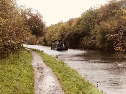
The Grand Junction Canal was authorised by an Act of Parliament in 1793, one of several potential schemes considered for a canal connecting the Thames, via the River Brent, to the Oxford Canal at Braunston. This would create a through-route to the burgeoning network of canals in Birmingham and the north of England - and beyond to the Irish Sea. Subsequent acts made provision for several 'arms' to connect to other waterways and significant towns along the Grand Junction's path. In 1795, a further bill additionally permitted the construction of a 13½ mile circuitous branch through the Middlesex countryside to terminate at a basin in the somewhat rural Paddington, then sitting on the fringe of London. By 1801 the main line of the canal, along with this branch, was open for business - changing the destiny of this once-bucolic swathe of England almost completely. Over the following century, the Grand Junction improved, modernised and consolidated with other Canals to become the Grand Union. Somehow this watery spine through middle England survived the coming of railways, motorways, and airports. It felt remarkable that the broad, still waterway continued to exist and could be used as a means of transport which largely served the same places it set out to in the Regency era. But now, of course, the towpath was quiet and the water entirely silent. Canals were places designated for sometimes expensive and exclusive leisure, but this one, carving through the distribution centres and business parks that flanked the western approaches to London had little scenic pull. The rain swirled around me, driving through my waterproof coat and whipping along the surface of the proud Grand Junction. The first stretch of the canal drove straight to the east, the Great Western Railway flanking the waterway to the south. The towpath was a narrow stony strip between the water and the grassy banks, still striated with red and gold autumnal foliage. Rain spattered from the broad leaves of the weed bank separating the canal from the back gardens and service yards beyond. This wasn't the ideal way to walk, but the satisfying crunch of the path under my boots was oddly mesmerising. Beyond the canal to the north was Stockley Park - once the seat of John Bennet, 1st Baron Ossulston who derived his manorial title from Ossulston Hundred, a sprawling division of the County of Middlesex now entirely subsumed into the suburbs of North West London. His seat was Dawley House, the grounds of which now provide the wide swathe of land housing the anodyne, glass and steel office park. Dawley and its surrounding farms had a remarkable and notable string of residents including Henry St. John, 1st Viscount Bolingbroke to whom the concept of a consistent parliamentary opposition is often credited. St. John employed architect James Gibbs to overhaul the house and garden designed by Charles Bridgeman to create a ferme ornée or ornamental farm, at which he was visited by Alexander Pope, Voltaire and Jonathan Swift. It seems the mighty Glaxo Smithkline and Marks & Spencer were not the first to create an artificial paradise of trees and lakes on these grounds. After St. John's death in 1751 the estate was acquired by the Earl of Uxbridge, greatly extending his holdings. Uxbridge commissioned a great wall around Dawley to keep smallpox at bay by preventing sufferers from entering his lands. Around 1779, Richard Tattersall began a stud farm near the boundary of the manor, known as Dawley Wall Farm, which provided the foundation of a business which remains the premier auction house for racehorses today. The estate finally passed to the de Salis family who slowly sold portions of the land during the 19th century. By the time the canal and railway arrived, the site of Dawley Wall Farm was a gravel pit which was perfectly situated to serve as a refuse tip, with barges of waste arriving to be offloaded and buried under the topsoil. Stockley Park, primped and perfectly green even on a rain-lashed November morning, is thus perhaps one of the earliest brownfield sites out here in the western suburbs. Dawley was the vanguard of lost villages of Middlesex: erased by the progress of London, gone before Heathrow could come to erase it.
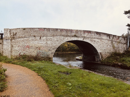
Beyond the crossing of Dawley Road, the last ghost of the deleted hamlet, the terrain became more familiar. The canal crossed through the southernmost reaches of Hayes, dividing the town from its railway station and a triangle of tall, modern flats which had arisen between the railway and the canal. Cranes moved slowly across the skyline at the site of the former Nestlé works, slowly disappearing into the ground to rise again as new urban living opportunities. The rain whirled on the wind now that the empty horizon had nothing to prevent it from rushing along the line of the canal. The Parkway loomed overhead: the traffic barely visible but evident by the cacophony of gasping exhausts as brake lights rippled along the line of cars already slowing for the interchange at Cranford. Below the aqueduct I was crossing, the Yeading Brook was obscured by trees and weeds, swollen by the deluge but still remote and unreachable here. The land around the brook had been artificially raised by the toxic spoil of Bulls Bridge Power Station, long since demolished and now surviving only as a headache for developers building new industrial zones on the contaminant-rich soils. I passed under the road, feeling the inkling of some sort of pilgrimage forming. The A312 haunted me, and I was still considering its exorcism when I arrived almost unexpectedly at Bulls Bridge. The squat, white arch marked the entrance to the Paddington Arm - this was where I'd meant to start, and if I'd heeded the forecast I'd perhaps have been arriving in less of a bedraggled and waterlogged state. I dared to lower my hood to survey the surroundings. To the south, the view was dominated by supermarkets and warehouses - the flat, dull landscape of the Heathrow zone stretching into the distance. To the north, the branch of the canal broadened and swung to the northwest, striking out for the railway. The rain had slowed to a steady patter on the surface of the water, and there was the slightest hint of a pale sliver of white in the uniform grey of the cloud sheet. I dared to allow some optimism to creep into my view of the weather and struck out along the towpath.
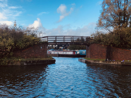
I began the seemingly interminable passage of the site of Southall's long-disused gasworks, still in the process of a long transformation into a new suburb. I'd passed this way a year ago, and little seemed to have changed - the site was still a plain of dirty brown earth with the striking form of the last blue gasholder drawing the eye along the railway. There had been some progress: the canal was now flanked with a solid perimeter fence where once a flimsy chainlink barrier had separated the unremediated ground from the water. Beyond, a new road struck out from Pump Lane, broad black tarmac forming a spine for a yet unborn village. Eventually, even the road gave up its attempts to impose order on the rust-coloured earth, which was turned into thick mud by the morning's downpour. The canal provided the hypotenuse of a triangle pointing due west, dotted with the ghostly impressions of decommissioned gas equipment which appeared like ritual circles. To the west, the green fringe of Minet Country Park edged the canal, hiding the tricky eastern course of the Yeading Brook in scrubby woodland. As I passed Blair Peach Primary School, named for the activist killed by Police Officers in Southall in 1979, the clouds finally parted to reveal blue skies flecked with white storybook clouds. Once again the weather had performed almost exactly as forecast. I counted my blessings for the almost unprecedented accuracy and weighed the options. I could peel off my dripping coat and stow it in my bag, or avoid an inevitable hex on my day and just walk it dry. I opted for the latter, there was no time to lose and a rare burst of Autumnal sunshine was never to be wasted. A terrace of canalside properties marked a return to civilization, as the Uxbridge Road - once the coaching route to Oxford, then the busy A40 - climbed overhead. Nearby, a local had turned up to feed the swans gliding along the now tranquil and blue-tinged surface of the water. He stood in a whirl of wings and crumbs, tossing slices of flaccid sliced bread into the breeze where they were snapped up before they'd landed. An advance guard of swans stalked the towpath, repelling any potential competition. As I nervously approached they began to advance with a low hiss and a determined stare. I decided to take a chance on the overground route, climbing up to road level beside the Hambrough Tavern, a decidedly 1960s pub built in squat and solid brick with a flat roof. The rather challenging crossing of the road remained preferable to attempt to navigate the maelstrom of birds and baked goods below, and as I descended back to the towpath via a slope leading down beside the Territorial Army centre, I could see the crowman continuing to toss a seemingly endless supply of old dough to the never satiated flurry. Aside from the avian excitement under the bridge, the canal was quiet - a far cry from its early days when this stretch ran alongside extensive brickworks serving the growing suburbs of London. The abandoned and repurposed sites form a stretch of pleasant and well-used greenspace along the western bank of the canal, dotted with ponds and small lakes which had filled the pits where clay had been extracted. There were also numerous docks and inlets along the canal here, and one of the larger wharves had been redeveloped into Willowtree Marina. Now a busy and prosperous over-wintering spot with on-site restaurants and services for boat-dwellers, it felt like a peaceful and calm zone now, and it was hard to envisage it teeming with noise and life as barges were loaded with brick destined for the city. A little further north, beyond the wide-open fields of Willow Tree Open Space, another inlet offered a different pace of moored life: Engineer's Wharf was surrounded by modern flats offering a waterside lifestyle with expensive restaurants on site. It felt busy, the boats overlooked by the anodyne housing units which leered over the pontoons. The canal felt like a curiosity here, and even further from the working waterway which it had so recently been. The colourful narrowboats ranked in the large, rectangular basin added colour and authenticity to the view from the high window - and no doubt value to the properties - though I wondered how many locals really regarded the canal and its associated towpath as anything more than a shortcut and a magnet for low-level crime in their otherwise respectable neighbourhood?
Leaving the former brickfields behind, the canal took a long slow turn to the east, winding around the edges of Greenford and narrowing to pass under Ruislip Road. The route of the canal, though somewhat ponderous, was a wonder of planning: despite navigating the hilly lowlands of West Middlesex there are no locks on the entire Paddington Arm. The canal slunk between suburban avenues in a chasm of mature trees which largely isolated me from my surroundings. Now that the sun had climbed above the remaining clouds the air was warm and I could feel my clothes beginning to dry. On the quiet towpath, distant sounds seemed closer and the thrum of the A40 hovered at the limit of perception. Between me and the road lay Marnham Fields: a broad triangle of woodland and rough grassland on the site of a former landfill, threaded with enticing paths which wound their way along the edge of the busy carriageway. As industrial uses for land around the canal declined, this part of the route has been allowed to return to nature as part of Northolt and Greenford Country Park. There was evidence of much care in the management of the woodland and despite the downpour earlier in the day, well-wrapped locals in high-end waterproof gear were out using the paths. To the west of the canal, a more recent initiative saw the creation of Northala Fields. Taking a name from one of the earliest incarnations of Northolt this modern park had replaced the Royal Borough of Kensington and Chelsea's recreation grounds. The new site sported a range of amenities but the most prominent were four huge conical mounds which aligned with Western Avenue and provided an acoustic barrier. One of the four mounds included a spiral trackway to its summit, and it was hard not to link these man-made vantage points with prehistoric activity in this long-settled corner of Middlesex. The mounds were in fact rooted in far more modern history, having been fashioned from the spoil of decidedly modern building projects such as the site clearance for the new Wembley Stadium. Perhaps the ceremonial internment of the hallowed turf on which England's World Cup victory took place wasn't a bad metaphor for the closure of the 20th century? In the paroxysm of national division which had dogged the past several years, such ancient history had been dusted off and rewritten. Blue passports and closed borders would reputedly secure a brighter future where trophies were apparently no longer out of our reach. From the nouveau barrows of Northala, the view over the land was hazy, indistinct and still reshaping in the brightening morning. Time would tell if this rebirth would rival 1966 - or would perhaps reprise 1666.
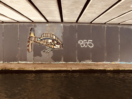
The concrete underpass carrying the Westway was lined with mosaics - an example of the kind of well-intentioned but soon forgotten civic project which so often decayed in these places. However, it was in surprisingly good shape and the stylised fish winked back at me in the sunshine as tyres screamed overhead. The contrast was striking, emerging from the green channel of the canal into this wide, flat world of rough, scrubby grass scythed in two by the great road. A bypass of the Uxbridge Road had been proposed as early as 1912 but the work was well underway by the arterial route boom of the 1920s. Western Avenue reached Denham by 1943, providing a continuous high-quality route from Hanger Lane to the edge of London. A motorway in all but legal standing, the broad carriageways shudder and twist through some of the surprisingly large tranches of green space that pepper the map of Ealing, a strategic route to Birmingham linked to the vast distribution and light industrial complexes of Park Royal. Intrigued and drawn as I am to these mighty expressions of the last century's motor boom, I wasn't sorry to pass by today. The rhythm and timbre of canal walks are entirely opposed to the enervating qualities of a road walk. I wasn't ready for that kind of pace or jeopardy. Today was about silent towpaths and crumbling warehouses. It was just what a walk in the closing months of a turbulent year should be.
The canal made a valiant attempt to return to its slumbers after the road bridge, with a line of trees screening both banks from the sprawl of light industry which hugged its course through Greenford. After passing under the impressively solid girder bridges carrying the former Great Western Railway to the Midlands and the Central Line, the towpath rose to cross the entrance to a turbid, algae-covered basin which sat incongruously in a nook created by a corner of a huge DFS furniture distribution centre and Sotheby's Fine Art storage facility. This land once hosted the sprawling factories of J. Lyons and Co. which supplied both their successful teashops and the retail market. Connected to the dockland tea warehouses on the Thames via the canal and to the railway network for onward distribution, the site initially included tea and coffee blending plants, but variously expanded to provide cakes, pies, chocolate, jellies, and ice cream products. From the Greenford site, Lyons' supplied a network of restaurants, shops and later hotels using early computing technology to streamline their logistics and avoid wastage in the volatile perishable food supply chain. Now, the site was an anodyne sea of white warehouses and the kind of durable landscaping which is designed to stake out the boundaries between premises rather than provide any kind of aesthetic relief. I thought of the huge concrete cliff of the Tower Hotel in the distant city, once the jewel in the Lyons' crown and now supported by a basement coffee chain and a mock street food market on a carpet of fake grass blanketing the riverfront. The retail landscape has changed, but those who bemoan the preponderance of coffee shops have short memories - these third places were an indispensable feature of the social fabric long before the second-wave titans like Starbucks and Costa arrived on the scene. The Lyons Corner House is the social mainstay of mid-century literature, a safe place where men and women could meet without causing moral alarm, where an inexpensive meal could be found to sustain the straitened or fortify the troubled. The beating heart of this fallen empire, a pioneer of the kind of distribution network which these anonymous sheds now provided, now languished beneath the waters of this abandoned dock.
The canal began to buckle and weave along the 100' contour line, skirting the slopes of Horsenden Hill. These ancient slopes divide Sudbury from Ealing and essentially mark the psychic boundary between North and West London. There is evidence of an iron age hillfort at the summit of the hill which stakes out its strategic importance. Little changed in 2500 years, with gun emplacements installed in the second world war to defend the western industrial zones from enemy bombers. The hill, though prominent in the surprisingly level plain between the Crane and the Brent, is not high - but its situation gives commanding views over London from the west. Today there were pockets of walkers braving the muddy track to the pinnacle: like many such views around the city, winter is best - benefiting from a lack of foliage on the unmanaged trees of the woodland. The curves of the canal, in turn, feel old and abandoned, littered with houseboats which were summer projects, now largely boarded up and forgotten, whispering the guilt of a job unfinished is always far easier ignored than the call of a warm house. Above the lower slopes, now given over to sports pitches and golf courses, the wooded knob of the peak glowers over Middlesex - one of its oldest beacons. Horsenden Hill stands as a genuine and ancient counterpoint to the modern cairns at Northala Fields. Together they formed an unlikely gateway to the city and a portal between the pre-historic and the modern. Perhaps one day our descendent explorers will pick up the sense impressions of frustrated comedians chasing balls down those hills in the same way that the archaeology of Horsenden brings us closer to the iron age Britons who defended its slopes.
You can see more images from the walk here.
Lost::MikeGTN
I've had a home on the web for more years than I care to remember, and a few kind souls persuade me it's worth persisting with keeping it updated. This current incarnation of the site is centred around the blog posts which began back in 1999 as 'the daylog' and continued through my travels and tribulations during the following years.
I don't get out and about nearly as much these days, but I do try to record significant events and trips for posterity. You may also have arrived here by following the trail to my former music blog Songs Heard On Fast Trains. That content is preserved here too.
