Scouting for Turkeys: Enfield to Epping Forest
Posted in London on Saturday 7th July 2018 at 10:07pm
It was a faintly ridiculous proposition, but I am it must be said, a creature of habit... I'd long ago booked the journey to London for this walk - speculatively scooping up cheap rail tickets in advance knowing that I'd probably end up planning the walk hastily at the last moment. I hadn't figured on a holiday to Germany nestling into the previous week, our return less than 24 hours beforehand necessitating a quick journey west from Heathrow, a little sleep and then an early return eastwards. I arrived at Paddington a little dazed by the whirl of travel and disarmed by the sheet of hot, dry air which hit me on leaving the air-conditioned railway carriage. True to form, I'd planned my itinerary for the day entirely on the fly, largely between naps on the train: I would head for the northern heights and walk the course of the Turkey Brook to the Lea. Beyond there? The valley had never really let me down, so it felt safe to see where I ended up without further planning. Plunging into the Underground for the journey to Kings Cross was strangely reassuring: after a week of being half-understood and perpetually a little disoriented, I was on more solid ground, back in the conversation-free zone of London. Trains at Kings Cross were reassuringly disrupted, the queue at the coffee shop frostily polite. I don't travel internationally often and I was struck by how doing so refocuses me on how English I am. Not, or at least I hope not, in that mildly racist and stereotypical football-supporting way. Not even today when a display of national pride was mandated by the World Cup. More in a sense that I'm culturally built for uncomfortable silences, frequent apologies and a background level of mild irritation. Already, before I'd really set off on the day's excursion I'd seen all of this. As I slalomed between disgruntled commuters trailing suitcases with little care and even less attention, I spotted that my cancelled train had been reinstated to run later than planned. I navigated to the platform and settled into the cool, quiet carriage. All too soon I was decanted at Finsbury Park to await the next connection to Gordon Hill. Cranes shadowed the parched platforms, swinging eerily and silently with payloads of ironwork for the two curved towers which were climbing into the air between the station and the city. Workmen ambled around the site - no need for undue haste at Saturday rates. Finsbury Park shimmered under the haze, the distant Emirates Stadium like a hovering red mirage. I slapped on suncream, guzzled coffee, jammed water bottles into the pouches of my rucksack. It felt good to be heading out of the city...
I'd been to Gordon Hill before - or at least the station, on a quest for the elusive third platform a decade ago - and I lazily remembered it as a sleepy, dormitory suburb of little note. The area was laid out in the 1860s on the land which formerly accommodated Gordon House - named for a colourful early occupant Lord George Gordon. Gordon was by most accounts, a skittish and inconsistent character who often took up causes for the sake of opposing the common view, but who also constantly railed against oppression and injustice. A staunch supporter of American independence and religious freedom, he paradoxically opposed more lenient treatment of Catholics - leading a march of 50,000 to Parliament in 1780. Following this, the so-called Gordon Riots resulted in the burning of Newgate Prison, damage to much property belonging to 'papists' and the death or injury of many hundreds of Londoners after the Army was summoned to put down the insurrection. Gordon was sent to the Tower of London for treason but was released after a trial where his Cousin, Lord Erskine, defended him by claiming the charge was a grievous over-stretching of the Treason Act 1351 and painting Gordon as seeking only to defend rather than injure his country. Gordon converted to Judaism and lived somewhat secretively in the home of a Jewish woman in The Froggery - a notorious slum in a dank and marshy area of Birmingham now buried under the equally benighted New Street Station. Required but unable - or perhaps unwilling - to provide securities and sureties for fourteen years of good behaviour, Gordon was finally imprisoned in Newgate where he became a popular figure providing wise counsel among fellow inmates, who greatly mourned his death in 1793 from typhoid contracted while imprisoned. Throughout his imprisonment, Gordon refused the support of his influential family in extracting him from the predicament which cost him his life. Dickens immortalised Gordon's demise in Barnaby Rudge, which takes the riots and subsequent events as its setting:
He had his mourners. The prisoners bemoaned his loss, and missed him; for though his means were not large, his charity was great, and in bestowing alms among them he considered the necessities of all alike, and knew no distinction of sect or creed. There are wise men in the highways of the world who may learn something, even from this poor crazy lord who died in Newgate.Charles Dickens - Barnaby Rudge, 1841
Any trace of Gordon's home on Enfield Chase was gone - the land now the sleepy repose of the dead in Lavender Hill Cemetery and the equally silent surrounding streets of quiet, decent homes. The suburbs here grew swiftly after the arrival of the railway in 1910 and many of the streets are rather modern in appearance. Stymied by the cemetery having only one entrance, I retraced my steps alongside the chapel and back onto Cedar Road. Here, four rather dour looking blocks of flats glowered over the Chase, delighting in incongruously rustic French names: Lombardy, Picardy, Burgundy and Normandy. This truly felt like the hard edge of London. To the south of me, more suburbs like this one stretched for miles, to the north little more than parkland and trees. At the next opportunity, the narrow and tree-shaded Cook's Hole Road, I turned north-west and headed a little back towards the west. A gap in the hedge led into Hilly Fields Park - a pleasantly wild stretch of public parkland which ranged along the Turkey Brook. As a gang of workmen sunbathed through a tea-break on the fringe of the park, I stepped up the pace eager to get my first sighting of water.
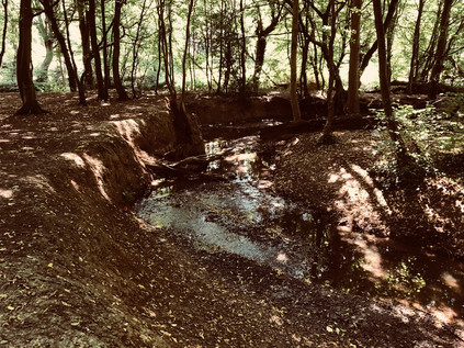
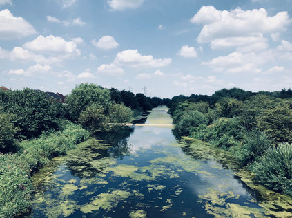
My entrance to Hilly Fields Park was via a path leading through unmown grasslands and tall, mature trees which creaked pleasantly in the near silence. Enfield Chase - a royal deer park - had occupied much of the land hereabouts until 1777 when the 8300 acres were divided among local bodies and landowners, adding to the already complex web of stewardship in the area. Part of the vast forest which stretched north and east of London, the Chase had likely already been emparked by 1154. It was not recorded as a Chase until the 14th century, spending many years in the ownership of the Mandeville family with the Manors of Edmonton and Enfield claiming common rights. After the arrival of the railway and the ensuing building boom, Enfield Urban District Council became concerned at the loss of recreational spaces and purchased 62 acres of land from Archdeacon Potter which became Hilly Fields Park in 1911. By 1921 a bandstand had been erected in the western, more open part of the park and brass bands provided popular local entertainment. My path intercepted the Turkey Brook as it entered the park in a thick strip of truly old woodland which wound along its banks at the foot of the park. An official path followed the edge of the trees, but I noted a less formal route along the banks of the brook under the canopy of venerable trees. Despite the dry weather and the mere trickle I'd seen forming one of its tributaries, the brook was flowing busily here, having carved a deep twisting fissure into the soft earth of the woodland. A few other walkers, and particularly their overheated, tongue-lolling dogs had made a preference for walking beside - or even within - the stream as it meandered along the valley floor. The walk was pleasantly challenging - crashing through the burgeoning undergrowth and hopping over mischievous limbs of trees fallen during the winter. It felt a world away from the industrial zones of Western Germany or the densely built southern suburbs of my recent walks. I'd had this stream on my list of walks for some time, but I'd often rejected it as not presenting a long enough diversion for a day of walking unless I somehow found a way out to the awkward-to-access source near Potter's Bar. Somehow though, the Turkey Brook had found its time and I felt ridiculously content schlepping along beside the water and navigating around the tight bends with their exposed root systems and tiny, eroded cliff-faces. Eventually though, the path crossed the brook and forced me into the exposed and sun-bleached park. I skirted the now restored bandstand and followed the path which reflected heat back at me relentlessly, already wishing I could walk closer to the water.
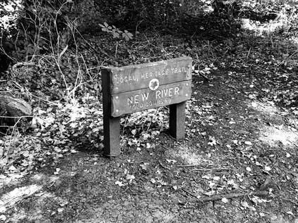
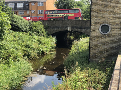
The path left the brook to bisect Clay Hill, a surprisingly busy and fast-flowing rat-run which proved a challenge to cross. Nearby, the former Rose and Crown was slowly reverting to a private dwelling: the fine, cottage-like buildings of the former public house were stacked with disused furnishings and shuttered, but its sagging gables and low windows still looked curiously inviting in the morning heat. The inn has a long association with local hauntings and intrigue and is much mentioned in connection with Dick Turpin, but this is likely due to its ownership by a Mr. Nott who is reckoned to be the Highwayman's grandfather. The Rose and Crown was once the focus of the tiny hamlet of Bridge Street, and sure enough, the brook passed under an old brick bridge a little north of the Inn. Eschewing the official path to the south of the brook, I crossed the bridge and turned east along Beggar's Hollow - a very old byway which is now primarily the entrance to Whitewebbs Park Golf Course. The name, while evocative in itself, is likely a contraction of Bullbeggar's Hollow, referring to a bugbear or bogeyman rather than a mendicant: "Something used or suggested to produce terror, as in children or persons of weak mind". Perhaps our modern fascination with the frisson of unexplored edgelands isn't entirely novel? The land on the eastern side of Clay Hill delights in a long history of ownership, patronage and the rise and fall of aristocrats - but was finally purchased by the Borough of Enfield in 1931 and Whitewebbs is now a mix of municipal golf course and public park. It began life as one of the historic manorial estates which fringe Hertfordshire, and was by 1570 in the ownership of Robert Huicke, physician to Henry VIII and Elizabeth I. The manor is often linked to the hatching of the Gunpowder Plot in 1605 - but this is disputed by historians of Eastbury Manor House in Barking who seek that honour. On the enclosure of Enfield Chase much of the northern part of Whitewebbs became part of Theobalds Park, while the remainder was turned over to agriculture. The manor house is now doing lowlier duty as a Toby Carvery nearby. Nothing it seems, was ever simple in the shifting band of rus in urbe around London. The brook, and with it my path curved along the boundary of Forty Hall, an estate first recorded around 1620 with a manor built during the following decades and occupied by Sir Nicholas Raynton, Haberdasher and Lord Mayor of London. Forty Hall was purchased by Enfield Council from the Bowles family in 1951, becoming in due course a museum and successful event venue. Much of the land around, designated as part of the Metropolitan Green Belt, is carefully protected with large areas left wild and not accessible to the public. The path provided along the edge of the estate was a fine one though, and well used by locals it seemed as I reached the confluence of the Turkey Brook with the Cuffley Brook, trickling in from the golf course to the west. The junction was hidden deep in the undergrowth, and it was easier to discern the dry gully nearby which was once the original course of the New River. The river originally took a dizzying meander around Enfield exploiting the natural contour of the land to reach London, but in 1859 the construction of the Docwra Aqueduct at Bulls Cross made this hard-to-maintain rural loop redundant. Having walked alongside the modern diversion of the river recently, I was struck by how narrow and rudimentary the waterless old channel seemed - but also how ambitious the aim of moving fresh water over a considerable distance had been given 17th century engineering techniques. The broad loop in the river had once provided the boundary to Forty Hall's extensive estate, a role now assumed by the Turkey Brook as it struck out east. I crossed a narrow lane near Bulls Cross where another well-maintained brick bridge spanned the brook, complete with a County of Middlesex warning notice about its unsuitability for heavy carriages or locomotives. The path continued beyond the road, a little way south of the water now, and climbed slightly to run along the edge of what had now become a surprisingly deep, wooded valley. I soon arrived at the intersection with the New River Path with the strange thrill of recognition which comes with stumbling across a familiar spot while walking a new route. The river crossed the brook in the simple metal aqueduct before heading underground to pass through the banks of the valley. Also buried near here was the 'Artificial Recharge Scheme' where around two-thirds of the New River's flow is diverted in tunnel to the reservoirs at Walthamstow. I paused to try to unravel the complex lie of the land here, while dragonflies flitted around the path, coming to rest on the deep green undergrowth. Even though the tangle of natural and man-made watercourses was almost entirely hidden from view here, there were tell-tale signs of water in the wildlife. This meeting of ways was a decision point - and the lure of the New River remained strong despite my relatively recent visit. Some ways into the city never lose their mystery it seems.
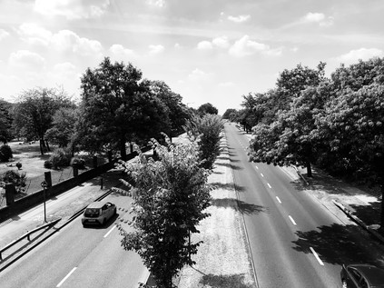
The strip of scrubby, litter-strewn land marooned between the New River and the Great Cambridge Road felt forlorn and derelict, pedestrians permitted only by the sufferance of the British Province of the Society of Jesus - although the notice on the permissive footway had been defaced to remove the final word, in effect creating a mysterious secret society in this most unlikely of places. The land here adjoins the well-tended grounds of a Jesuit school, St. Ignatius' College, but the course of the Brook remains largely wild and untouched - presumably on land stockpiled for future expansion of a school deemed 'good' by OfSTED. From the crossing of the New River, I'd been able to hear the swish and drone of the road ahead - and the long walk through quiet suburban parks made the sound seem alien and unwelcome. Between the overgrown edges of the path up ahead I could see the silver flash of hubcaps against the grimy standard-issue anti-pedestrian fencing of the road's median. The path sputtered out suddenly onto flagstones at the foot of a steep staircase to the footbridge. Cyclists were syphoned off to the south in pursuit of an underpass which apparently lay some distance away. As I clambered to the peak of the rather slender bridge which swayed gently with the effort of holding me above the traffic, I considered the impressively broad dual-carriageway beneath: this was ancient Ermine Street, the Roman road to Lincoln and York. It had begun its journey in the heart of the City of London, sluggishly pressing through the traffic of Dalston and Tottenham, edging along the wide, flat bottom of the Lea Valley and patiently awaiting its moment of escape. Suddenly, at Bruce Grove the road wheels into the suburbs and emerges from the one-way system as a classic 1920s arterial route - one of the 'Great' roads which radiated from London, strewn with modernist factory buildings and fringed by large brick villas. But the 'Great Cambridge Road' doesn't go to Cambridge anymore - at least if the sanctioned destination signs are to be believed. Only Enfield and Hertford are name-checked now, and after that? Nothing. Some signs clearly have the old destination plated over, traffic directed east to the M11 which snakes out to the northeast. The old road remains busy - still the easiest way to escape from the east of London to the north, and those in the know prefer its long, straight lines to the gently deceptive curves of the motorway. The Romans knew best it seems, and neither time nor transport policy has succeeded in downgrading Ermine Street from its primary route status. I carefully descended from the alarmingly vibrating frame of the bridge, taking the continuation of the path as it burrowed behind Enfield Crematorium, passing a sizeable fringe of the grounds which wasn't yet used for burials. A curiously unmarked series of masts, pipes and generator buildings nestled sinisterly in the undergrowth to the north of the path but probably I reasoned, had an utterly mundane purpose in a state heavy with surveillance of the least consequential things. The humid air closed in under the overgrown foliage, and the heat and stillness gave the path a malign feeling. This was part of the London Loop footpath, and while I've stumbled across - and along - many sections which were less than salubrious, this was one of the least inviting I'd found for a while. I was glad to pass under a very low railway bridge and to escape into the open once again near Turkey Street station. A corner of parkland had been recently refurbished to include a circular bench, currently in use to support the flowers and photographs of an impromptu memorial, while the brook emerged from under the rails by way of a solid brick bridge, now flowing along the street with which it shared a name.
It's hard to know exactly which came first - Turkey Street, the hamlet into which I was now walking has a long etymological history, moving from Tokestreete via Tuckhey Street to its current name in the space of around 400 years. The brook seems to have been named from the hamlet rather than in the more traditional practice, and locally remains the Maiden's Brook for some. The name appears to be derived from a family name rather than any reference to bird or country, and yet it has persisted in this form since around 1800 while the hamlet it describes has changed considerably. After a walk along the attractive banks of the brook where a terrace of houses tumble along the slope to reach the water, I emerged onto the main drag of Turkey Street. It was a seething, channel of kebab houses, bus stops and slow-grinding traffic queues. I made a crossing, mostly to avoid two bored looking Jehovas' Witnesses who were sunbathing listlessly in their button-up white shirts on the corner near the bridge. It was here that the brook begins to be tamed by mankind, squeezed into a culvert and straightened to plough its easterly path. I gingerly glanced over the bridge, sandwiched between hairdressers and takeaways, rather dreading what horrid pollution I'd discover. In fact it was what I perhaps couldn't see which alarmed me more, as a beautiful silvery adult fish gazed sightlessly up from its resting place on the riverbed appearing to have been felled by some invisible pollutant. I made a mental note to look out for any others and to report them. The suburban centre of Turkey Street sat astride the old route of the Cambridge Road - still long and straight, but now the sluggish distant cousin of the grand and aspirational arterial route nearby. I realised that I'd be in the company of the London Loop for much of the rest of my walk now, so I let the familiar signs guide me through the tense locus of overheated people and shuddering cars. I remembered once picking trains specifically to cover this suburban route, and feeling this same unease while passing through the area even then. This felt like somewhere I wasn't welcome and just shouldn't be, and so I turned east at the first opportunity, tramping more contentedly along the bank of the brook as it formed the boundary of Albany Park. The water bloomed with algae and moved slowly between reedy edges, but despite its deep and straight channel, it felt unusually natural and timeless amid surroundings which shimmered with opportunism and immediacy. The brush-dry parkland looked like a recently mown hay meadow and was speckled with families lounging on the stubble in the intense sunshine which had settled over London for the day it seemed.
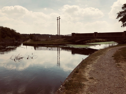
At the edge of the park, the path rose to cross Mollison Avenue - the industrial spinal route between outer London and the warehouses and distribution parks which scatter along the eastern edge of Edmonton. This crescent of modern, swiftly-built plastic sheds shows as a bright white mass on aerial photography, like a concerning presence on a body scan. The road was a little over-enthusiastically named for Captain Jim Mollison, early aviator and sometime husband of Amy Johnson - ostensibly due to the presence of the long-serving Weston Aerospace works nearby in Enfield. Below the bridge, hidden deep within a clump of well-established trees, the Small River Lea joined the Turkey Brook. The little river trailed away north, towards Waltham Cross where I'd first crossed this waterway some time back. This boundary crossing also confirmed my passage into the Lea Valley, and with a line of pylons walking south towards the Thames and the bulky chimney of Enfield Power Station towering over the view, it felt strangely comfortable to return to this familiar, semi-urban landscape. Ahead of me the hills of Essex reared up, woodland spreading down from their crests. From here it felt like utter folly to attempt to climb them in the heat of the afternoon. The terrain wasn't helping - offering teasing names like Enfield Wash and Freezy Water to remind me how hot it was trudging through the parched landscape. But this was a place dominated by water and the floor of the valley was noticeably cooler. I parted company with the Turkey Brook here, letting it slip away to the south, through the Prince of Wales Open Space towards the River Lea. It was possible to walk a little further along it, but I'd decided to press on eastwards towards Enfield Lock on the Lee Navigation. A lock has existed here since 1725, with the buildings scattered around it dating from various periods of reconstruction. The Lee Conservancy Toll Office, an attractive cruciform cottage near the lock, is one of the oldest remnants, dating from 1889. Lock 13 sits on a quiet, straight stretch of the Navigation which forms something of a boundary between the redeveloped industrial zones of the western valley and the more rural eastern banks. In the midst of this, clustered around the lock are the much-gentrified remains of the Royal Small Arms Factory. Established in 1816, the site provided greater capacity for delivering ordnance than the previous site at Lewisham in a mill originally used to make armour in the 14th century. The modern buildings at Enfield were not a swift success, fighting closure at several points until the Crimean War brought an arms-making boom in 1853. The site modernised rapidly, adopting mass-production techniques from the USA, and installing steam power to replace the waterwheels which had previously driven the machines. Nevertheless, the tiny pattern of streets which had developed around the factory did not extend far outside the island site bounded by the various channels of the Lea, and generations of families tended to remain within both the village and the employment of the factory. The works continued to thrive through the early part of the 20th century, but entered a decline after the Second World War, partially closing in 1966 and finally shutting its gates in 1988 after a series of privatisations and sales. In some ways little has changed: the mid-century terraces of Ordnance Road face the older factory worker's housing on Government Row across the Navigation - but beyond this, the island is a modern development on private land. There are few ways in or out, and the area has the air of a gated community. I crossed the head of the lock and turned south onto the scrubby path which ran alongside the canal, soon turning aside to circuit Swan and Pike Pool. I picked my way through the depressing mass of litter to a bench I'd rested at on a previous walk and took the opportunity to re-apply sunscreen and greedily drink water before continuing. The pond was quiet and still with a vague waft of refuse drifting in from the incinerator nearby. It was oddly reassuring to be back in the Lea Valley once again, despite its evident drawbacks.
I crossed one of the tangled branches of the Lea which splay around the island, and then the river's main channel by way of impressive concrete footbridges which stood incongruously in otherwise empty fields. Since I'd passed the entrance road to the King George V reservoir, civilisation had made a point of retreating suddenly in the way it often does in these parts. I picked my way along a rough but pleasantly crunching towpath with tall grass waving beside me and only the occasional furiously cycling local skittering by. The path turned north and then east, fringed by impressively tall thistles and extensive crops of nettles. This was Sewardstone Marsh and new territory for me. I'd walked on the western side of the vast reservoir on previous treks, sticking with the line of the Lea Navigation. The eastern bank was wilder and stranger - unmistakably Essex now. My path turned into a rough, broken driveway serving various dilapidated industrial yards which appeared to specialise in disposing of the evidence of motor accidents. If in doubt, it was burned - as too was the large yellow County of Essex signpost nearby advising against fly-tipping. There was a phantom-smell of fire and smoke in the air, a little disconcerting given the furious heat and the dry land. I reached a junction with Sewardstone Road - a thoroughfare I'd considered walking before but which had seemed oddly remote despite being sandwiched between suburban Waltham Cross and Chingford. The road had the feel of a country lane, with a huge farm building converted to a gastropub and many of the old market garden premises now large, rather ostentatious luxury dwellings with gateways capped with stone eagles and drives haphazardly populated by BMWs and Range Rovers. The shimmer of heat and the lack of any other pedestrians made the road feel lawless and dangerous. Cars flashed past at illegal speeds on the long, straight flat valley floor heading for disreputable Car Boot Sales and perhaps a Carvery afterwards? I battled the stereotypes but couldn't quite push them aside, so I decided to follow the London Loop markers once again, striking out over a stile and across a field of tall grass, leaving the road behind me. A well-walked lighter strip of grass indicated the route of the path, though I didn't feel entirely comfortable until I'd passed the first hedge and found myself on a more established track. This land felt contested and defended, though by who I couldn't imagine. It felt like there was no-one outside the confines of a car's cockpit for miles. The path climbed, slowly at first, then more steeply as it zig-zagged towards the summit of Barn Hill and the promise of welcoming tree cover at last. Near the summit, the path dived off into a thicket of trees and over more stiles, emerging at the top of a field where it seemed to duck into the beginnings of Epping Forest. A pair of donkeys sputtered and brayed in the next field. As I crossed the field I was startled by a young, female voice: "Someone's coming! Help. Do you know where we are?". As I approached the trees a small ground of Girl Scouts emerged, maps in hand and compasses dangling around their necks. One of them took the lead in talking to this strange man who'd emerged from the woods: "Are we here?" she enquired politely, pointing to the laminated offcut of Ordnance Survey map they were carrying. "No", I replied, "You're here" - indicating a point on the red dashed arrow they'd clearly been trying and largely succeeding, to follow. They seemed bewildered that the path wasn't marked on the ground - especially where it crashed into the rough, confusing wooded edge of this field - but reassured that they hadn't strayed as far as they feared from the route. I showed them my GPS marker on my 'phone screen and described how the route ahead led to a proper path. After asking about the Ordnance Survey app and a final nervous query about whether the donkeys were loose, they happily trotted off across the grass while I ungracefully flipped myself over the stile and into the confusing wooded patch where they'd come to grief. At this point, I remembered a friend's remark that if I passed nearby today he'd wave from Gilwell Hill where thousands of international Scouts were amassing for a 24-hour event. I figured these weren't the last Scouts I'd see today.
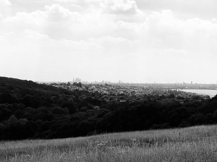
I emerged on Daws Hill with a decision to make - the narrow road ahead lead downhill to Chingford, but meant walking the margin of a busy, fast-running and poorly-sighted lane. I decided instead that the physical effort of tramping across two further hills was preferable to a tense roadside walk, and set off into the driveway of Gillwell Park, the headquarters of Scouting in the UK. As I approached the site, the noise grew from a dull rumble to a full-throated roar. Thousands of teenagers were here - cycling, trekking, camping, singing - it was like a massive theme park based around the wholesome fun I'd read about in Enid Blyton books but never quite found a way to enjoy myself. Happy groups of tanned, healthy young people drifted by speaking a variety of languages and were always faultlessly polite. I spied a veteran scout ahead occupying a deckchair guardpost and made directly for him to check I could pass through to use the footpath. Given that I was a large, sweating, red-faced older man attempting to pass the gates of a campground full of teenagers, he was surprisingly accommodating. He eyed me as I walked towards him and clearly recognised I'd walked quite a way to get here. After a quick chat he indicated where I needed to head to take the path which skirted the site and ascended to the top of Yardley Hill. A little before the summit an unofficial path struck out into an open field. Instinctively, I passed through and headed across the grass, admiring some impressive kite flying which was taking place nearby. As I turned west to find my path onwards, the view of the valley below took my breath away. The silver mirrors of the chain of reservoirs snaked southwards, leading towards a distant city of towers and shadows. Beyond the water the land rose, a green bluff indicating the higher ground where I'd set out this morning. London spread across the edge of valley, not seeming quite so impossibly large or endless here: the tower blocks of Edmonton were tiny upended bricks, and the mass of warehouses and retail shacks along the valley floor looked like an unpainted architect's model. It was impossible not to be moved by the sight of the vast metropolis - and I thought back to circling above the same area yesterday as my flight from Düsseldorf waiting for its appointed slot at Heathrow. The same territory viewed from a different perspective. Then, like now it all felt like it made sense and fitted together. I realised that, despite years of protesting otherwise as I plodded pavements and shadowed streams, I'd begun to know parts of this messy tangle better than I imagined possible. But there was still so much to discover... I made my way down from the hill and immediately climbed again, heading towards the top of Pole Hill. The view wouldn't be great with the trees fully in leaf, and with my knee protesting at being forced into another painful ascent and the air somehow denser and hotter than ever here in the forest, it felt ill-advised - but this seemed like a time to honour tradition. When I finally found my way to the top of the hill, confused by approaching from a new angle, I paused to admire the hazy view over London once again. When I'd first come here it felt like a frontier passed - the edge of a vast forest which must surely remain out of bounds to the likes of me? Since then I'd tramped the woodland paths, returning here again and again on route elsewhere. I touched the obelisk, observing the Meridian, and headed back downhill via the same path beside the golf course which had brought me to Pole Hill on my first visit. At the end of the path, Chingford suddenly began, the forest breaking against it like a wave on the shore. The streets were oddly quiet around the station, a pensive and strange feeling in the air. I felt like I'd descended into a deserted city, and wondered how long I'd been up there in the woods? Then, as I crossed the street to enter the station a loud roar erupted from the bars on the High Street nearby. England had scored. Football, however unlikely it seemed, might just be coming home. I collapsed onto the waiting train and dozed my way back to Liverpool Street. It was probably not wise to attempt this kind of walk on the hottest day of the year so far, and I was feeling the effects. Somehow in the heat the strangeness of Essex was more marked, the stillness of the forest curiously quieter. I was almost relieved when a reveller crossed the concourse of the station sporting a crudely painted Cross of St. George across his red, sunburned cheeks to bark just inches from my face: "IT'S COMING HOME!". Having not spoken for hours and still feeling weirdly disconnected from civilisation I blinked quizzically at him and stayed silent, not sure whether I was expected to agree with him, fight him or run away in terror? He looked at me for long moments, expecting some kind of reaction and getting nothing. Then, meekly and almost thoughtfully he looked down and quietly said to himself "It is. It's coming home..." before scurrying away to yell at his friends some more.
It had been a very unusual day...
You can find a gallery of images from the walk here.
Lost::MikeGTN
I've had a home on the web for more years than I care to remember, and a few kind souls persuade me it's worth persisting with keeping it updated. This current incarnation of the site is centred around the blog posts which began back in 1999 as 'the daylog' and continued through my travels and tribulations during the following years.
I don't get out and about nearly as much these days, but I do try to record significant events and trips for posterity. You may also have arrived here by following the trail to my former music blog Songs Heard On Fast Trains. That content is preserved here too.
