London has an enviable reputation as a resilient city. It has been burned and flooded, bombed and relentlessly attacked from within - yet it stands. Its people, in particular, are regarded as stoic and resolute - defiant against all the odds. Even during the recent terrorist attack at London Bridge, they were to be found hurling chairs and pint glasses at the assailants, rather than turning tail and running. Some of this is, of course, hyperbole - and some wishful whimsy - but there's no denying the endurance the city has shown over a couple of thousand years. But London has two key weaknesses which have resurfaced over the millennia to threaten the city's hard-bitten citizens - the very air and water which sustain them. Both have rebelled against being used to support the sheer concentration of humanity that the city presents and both have proved real threats to the health of generations of Londoners. During a weekend where Sadiq Khan stepped up his efforts in a campaign to detoxify the air in central London using some slightly confused but well-intended statistics to prove his points, I found myself approaching a solution from an earlier age. A time when the importance of clean drinking water wasn't an established scientific fact, but the evidence of Londoners' senses told them things weren't good and that something needed to be done to sustain the supply without the torrent of filth that had begun to choke the natural rivers which tumbled towards the Thames.
It was good to set out early, stumbling from our Shoreditch hotel towards Liverpool Street for early coffee - wondering quite how the NatWest International Markets employee had the early-morning energy to grope and manhandle a female colleague as they waited for a huge order of drinks for their team back at the office. The barista made my drink swiftly and with a raised eyebrow and shake of the head, passed it through the front of the stall rather than the serving window, which was fully occupied by the amorous pair. Downstairs the station was eerily quiet, the first few trains of a Sunday morning beginning to shudder into life. I was familiar with the run out to Theobalds Grove from an earlier walk, but the chance to set out early and watch misty dawn rising over the east of the city was a rare opportunity. I saw the territory I'd walked, some of it drab and downbeat in its day-to-day life, glowing and burnished in the dawn. I had a long walk ahead but mercifully, due to a lack of real planning, I had only the vaguest idea of the total distance I'd cover if all went as I hoped. The scheme was simple enough - to strike out west from Theobalds Grove and to find the New River. Then to follow this artificial waterway, venerable despite its name, to its terminus on the fringe of the City. The New River has wound through other walks in the north of London - tantalisingly paralleling my travels along Green Lanes, crisscrossing my excursions from west to east through Woodberry Down, and complicating my search for lost rivers and roads. I'd also visited its usually forbidden terminus around a decade ago during an Open House weekend, when an eccentric Islington local decided to give impromptu historical lectures and appeared to actively loathe the New River for some unknown slight. Today though, I'd stick with the River as far as I could, navigating reasonably close to its path where its course disappears or dives inaccessibly between back gardens. As my few fellow passengers trudged off towards their homes or jobs in Waltham Cross, I turned west towards the Hertfordshire countryside. This was an ambitious undertaking, which had been a long time coming...
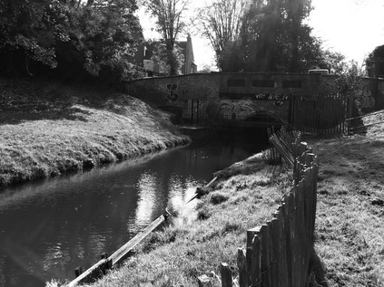
After a brief suburban trudge alongside the almost-hidden Theobalds Brook which was screened from the adjacent and properties by a low brick wall and a line of trees, I found myself taking an unexpected turning beside Cheshunt FC's home ground. Here, the Paul Cully Bridge climbed over the A10 as the road beneath took a dead-straight course towards the M25 and Central London. The bridge was opened in 2010 and named for a late councillor who had long campaigned for an improved link between the communities in this part of the Borough of Broxbourne. The opportunity finally came from a fortuitous mix of Sustrans funding and the decision to host Olympic events at the nearby Lee Valley White Water facility within the borough. A strange video exists of the gleaming white bridge, lined with schoolchildren who are slowly passing a flag bearing the ill-starred London 2012 logo over the bridge, inch by endless inch. Councillor Cully's case for the bridge proved well-founded, as it appeared to provide a useful link to a local school, and between the communities that cluster along the railway line and the valley floor here. Despite its perhaps ill-advised white paintwork looking mossy and traffic-stained, it was clearly well used at times - though quiet this early Sunday morning. Between the distant shapes of factories and housing looming in the mist a vast flat area of former green belt land, part of the estate of King James I's Theobalds House, had recently been parcelled up as 'Park Plaza' - though only sporadic development appeared to have taken place west of the Great Cambridge Road so far. The great house which King James acquired in exchange for Hatfield Palace in 1607, and where he died in 1625 was swiftly and surely destroyed during the interregnum, with the estate passing between the crown and various nobles after the restoration. By 1888, the estate was in the hands of the Meux family whose fortune had been made in brewing. Lady Meux had been a City barmaid herself, and on hearing of the impending destruction of Temple Bar, the now inconvenient gateway which bottlenecked traffic passing along Ludgate Hill, paid the sizeable sum of £10,000 to have the structure dismantled and re-sited on the Theobalds Estate. It remained, slowly decaying after Lady Meux's passing, until 2003 when the campaign to return it to the City finally succeeded. Having made a more expensive and equally painstaking return journey, it now sits in a somewhat anodyne new development at Paternoster Square - but is at least preserved in good condition. As the bridge descended into the fields beyond the road, pockets of persistent mist floated in the dew damp grass. The sun picked out the droplets of water on a low gate leading down to the New River path which curved gently in from the north. Here my walk was to begin in earnest, with just the distant murmur of the M25 for company.
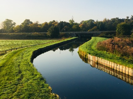
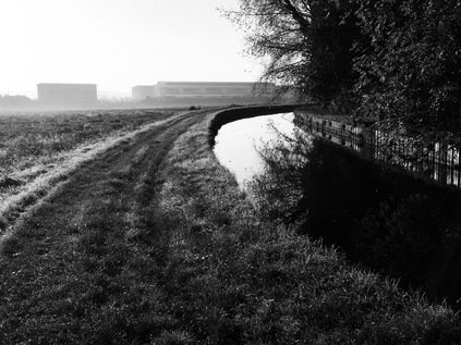
The New River path is largely a permissive right-of-way which runs, with some breaks and diversions where necessary, between the point where the waters part from the Lea at New Gauge in Amwell roughly to the river's current and former endpoints in Central London. For much of its route, it is a simple, flat grassy space beside the river provided under the sufferance of Thames Water, with a few more formal surfaced sections where it intersects with other's land and developments. For that reason, it felt sensible to tackle the path now rather than during the comparatively muddy winter months when parts may well become impassable. I could perhaps have travelled further north to start walking closer to the source, but my intention was to reach the city in a single day of walking on the basis that I had more time than usual and didn't need to maintain a furious pace. That said, it was hard not to be lured out into the flat, open Hertfordshire countryside which flanked the settlements chained along the valley. I consoled myself with several additions to the list of walks I might take, and set off down to the river, immediately passing under the busy B198 via a modern, graffiti emblazoned underpass. The river curved gently into view around an unharvested field, it's surface a still mirror of the morning sky. The channel ran between wooden boards, broadening slightly to encompass an island where Lady Meux is said to have kept a menagerie, though the only animal life here now was a squadron of ducks that patrolled the pool around the island. To the south-east, the low anonymous hulk of News International's print works rose from the mist ominously. The clamour of the road was growing, and I knew I'd soon be crossing into London. These last few yards of countryside felt precious and worth savouring as the path turned south and crossed a byway which led towards Tottenham Hotspur's training Bullsmoor ground. Soon though, the river was swallowed by the twin concrete tunnels of the aqueduct which carried it over the six lanes of the M25 careering towards the sliproads of Junction 25 and the tunnel under Bell Common. The footpath ran across the roof of the channel, providing a broad dry crossing point that emerged having crossed to the western bank of the river. This habit of changing banks at crossing points would persist for much of the walk, and soon became part of the routine of walking this surprising and sometimes confoundingly elusive waterway.
Given how long the sound of the motorway had prefigured my crossing from the north, it lapsed surprisingly quickly into silence once I was within its circle. The river soon reverted to its sedate, grassy state for the journey south. A kink in the otherwise remarkably direct course took the river around the grounds of Capel Manor, which can be traced back to 1547 when 'Capels' inscribed on a contemporary map denoted the seat of Sir George Capel and his line - the Earls of Essex. Now the simple but elegant 19th-century replacement building is occupied by Capel Manor College - specialising in horticultural and agricultural pursuits. The college is set in extensive gardens, which in turn hide the ruins of the 15th-century manor house. It's clear that this spot on the fringes of London, perhaps a day's leisurely ride out, was the chosen home for the influential and well-connected until relatively recent times, and still harboured a number of expansive if more modern well-heeled dwellings even now. As I meandered with the river I spotted a curious thing - a crablike claw, stripped of flesh up to the solid, razor-like hooks but still pink and fresh, was discarded on the grass. There were in fact several here, all seemingly recently deposited. I pondered the distance from the De Vere Hotel, now occupying Theobalds House, wondering if a fox had raided their waste bins? However, these weren't the last similarly intact claws I'd see on my travels - and some research indicated that the River Lea and its associated system had been invaded some years ago by aggressive American Signal Crayfish. Their aggression, along with a plague transmitted by these non-native incomers had all but exterminated the native species - but perhaps now something was preying very effectively in turn on these new denizens of the river? There were certainly stories of bucketloads being hauled out by restaurateurs, but this looked a little smaller-scale - maybe an ambitious fox or a bird?
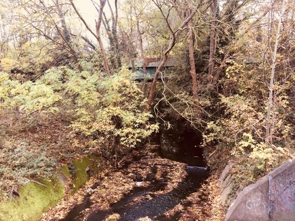
I passed through a kissing gate of a type which was to become very familiar over the course of the walk, which took me across Turkey Street leading west from the station of the same name which I'd passed through earlier on my journey out to Hertfordshire. There is nothing to connect the street or the brook from which it takes its name with the seasonal fowl, and it appears far more likely to be a corruption of a local family name. The brook presented a genuine challenge for Myddleton when plotting the course of the New River. The channel uses gravity to convey water towards the city, carefully hugging the contours of the landscape to gradually descend from the northern heights. The valleys of the various tributaries of the Lea which carved into the higher land thus proved problematic, and the only sensible solution at the time of building was to take the otherwise straight river in broad loops around the heads of these streams. Thus, as the footpath descended into the surprisingly steep gully in which the Turkey Brook runs, the original course of the New River swung west into open land. A path followed it, and the temptation to take it was strong - but the wish to see my route through, along with the desire to get a look at the placid and shallow Turkey Brook at the foot of its valley kept me on track. The New River was straightened by the building of the Docwra Aqueduct in 1859 which takes it above the brook, and then directly south via a long straight section that emerges from culvert where the path ascends from the valley. The old course of the river is patchily extant, a ghost waterway in places and a weed-choked reedbed in others, but can be walked - providing the potential for another future expedition perhaps?
It was here, contemplating the huge detour which the river had taken to follow the 100ft contour line around the valley, that I began to really appreciate the undertaking that the New River represented. Edmund Colthurst had begun the work on receipt of a Royal Charter in 1604 but soon ran into financial difficulties. Myddleton took on the task of completing the works in 1609, with Sir John Backhouse providing considerable support, not least in the form of expensive land in Islington for a reservoir at the river's head. Even then, the project threatened to collapse as landowners refused to grant leave to pass over their fields, fearing inundation of crops and drowning of their stock should the channel burst its wooden retainers. Even then, the value of these lands on the edge of the city was a vexed question, and the great tradition of British reluctance to get behind new developments is not a new one it seems. Only the intervention of King James I as a guarantor and shareholder saved the project, and finally by 1613 the river was bringing fresh water from the springs of Amwell to the fringe of the City at Sadler's Wells. I realised with some reluctance as I approached the crossing of Carterhatch Lane that the section which I was walking now, passing through Forty Hill with its 17th-century hall and estate, was probably the last truly rural stretch of the river which I'd see today. Beyond here the river was hemmed in by development on both sides, the path discontinuous and sometimes elusive. It was remarkable though that the New River had survived above ground quite as far into London as it has while other more venerable rivers were fouled and spoiled, and finally cast into hidden culverts. The influence of the King with his edict that casting filth or carrion into the river or planting trees close to its banks would incur his 'displeasure' seems to have been oddly effective. The New River Company, founded in 1619 to manage the river and its associated supplies of water to the City survived too, managing the waters until the formation of the Metropolitan Water Board in 1904, proving the perhaps surprising point that publicly owned utilities are a surprisingly modern phenomenon.
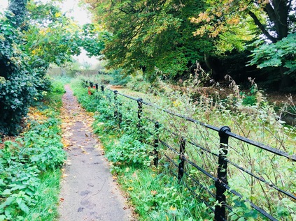
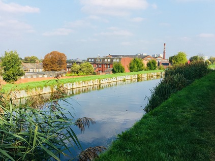
Forced to step away from the river here for a spell, I crossed to the western side via a pedestrian bridge and ventured into the hinterlands of Enfield. The river once made another loop here, passing along Southbury Road and into the town centre in a channel which has been preserved as a civic amenity. The businesslike waters now flow underground by a more direct course, but the vivid green of the algae bloom in the channel makes for an interesting walk into the town, which was just beginning to awaken. Sunday morning in Enfield was slow to start - the sizeable supermarket on the edge of town not open yet, and the smaller businesses only now beginning to spring into life. Here in Enfield, even the disconnected loop of the river disappears under the buildings on the north side of the main street, and I decided to pause for coffee at a spot which might well have been over the course of the old channel. I didn't spy the river again until I reached the bridge at the edge of Town Park, where I recalled seeing the river for perhaps the first time many years ago. This green space is the last remnant of the great Enfield Old Park - a hunting ground for royalty and a reserve for game - and the loop of the river is overhung by weeds and plants here in a way which would be unthinkable along the well-tended length of the working channel. The once sprawling park has endured numerous indignities over the years: being enclosed by act of parliament in 1777 and then suffering the fate of much of the modern green belt in the borough by being parcelled between several golf courses in the late 19th century. With both the Great Eastern and Great Northern Railways well established by the turn of the 20th century, the growing desire to move out of the city and to commute from the suburbs made development of the land irresistible and much of the remaining park disappeared under various well-to-do estates south of Enfield. I crossed over the river loop, leaving it to turn back east towards its original course while I started the steady climb up Carrs Lane, a sudden delve into a rural and tree-shadowed thoroughfare that bisects Bush Hill Park Golf Club. It was strange to be walking through a tunnel of greenery with the swishing and thwacking of club and ball just beyond the hedge, cries of delight or dismay echoing through the trees near gates sternly marked as PRIVATE which allowed members to pass from the green to the next tee by crossing the lane. Named for a prominent Victorian landowner, William Carr, the lane was once part of the drive into the Old Park and up to Windmill Hill on the western edges of Enfield. Now it holds its nerve as the last sliver of public land in a privatised and primped landscape of flags and bunkers.
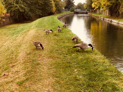
After a few minutes of pleasant country walking, Carrs Lane deposited me on a busy corner near to familiar ground at the top of Bush Hill. Several of my walks had brought me close to this point where the New River flowed back into the open and along a raised bank of earth which was erected in 1786 to replace a timber and lead aqueduct known as the Bush Hill Frame. The structure carried the river over the steep and narrow valley of Salmons Brook, the little stream still trickling below the raised channel. I was curious to revisit the Clarendon Arch which I'd stumbled across on a previous visit, but sadly the narrow staircase down to the viewing platform was fenced off and the whole site was looking a little decrepit and unloved. Under the road here the stone arch has allowed the passage of the river over the brook since 1682, and it was truly a saddening sight to see this small but significant piece of history hidden from view. I returned to the road and pressed on south to Mason's Corner where I met Green Lanes, and where I could once again access the river bank. Now, for quite a distance, the course of the ancient drover's road and the river were inseparable - both taking advantage of the flat land and slightly descending contours to advance on the north of the City. The road and the river swayed closer and further apart as they progressed south, with the river regularly passing under shallow bridges carrying suburban side-streets, heralded by the now-familiar green kissing gates, often necessitating a switch to the opposite bank. For the first time here I began to encounter others on the path - since I left Theobalds Lane I'd seen only a handful of dog-walkers on the path, all of whom had been keen to bid me 'good morning' but now mute joggers and self-absorbed walkers were more often sharing my route. Thankfully, given the grassy and often uneven surface, cyclists were less commonly spotted here unlike on the towpaths of Central London where they cannoned uncontrollably along the narrow ledges beside the water. Despite the river's relatively broad and uncluttered banks through Winchmore Hill, the path became surprisingly fractured here, often deviating into roads and alleys. I found myself trudging along the tantalisingly named River Avenue which mocked me by following every minor kink in the route of the river which ran beyond its back gardens. Under a suddenly gloomy and oppressive sky, I finally regained the path properly near Palmers Green Mosque via an uninviting alleyway and a clamber up steps set into the bank beside another gate sitting in the midst of the grassy bank, strangely isolated from any fence. Soon after setting off, I was confronted by a persistent and immovable gang of geese blocking my way. I tucked my hands well into my pockets, my chin into my chest, and pressed on, swerving around the biggest of the birds as he strutted along the path looking for food, apparently unconcerned with the foolish human murmuring for him to 'stay calm'.
The river turned west and I was again forced to detour by road, briefly walking north along Green Lanes to find a footpath back to the bank via steep steps down beside the fine municipal architecture of Southgate Library. This curve of the river felt familiar, with the railway high on an embankment to the west, screened by mature trees which parted to reveal the brick culvert of a bridge. Here Pymmes Brook passed under the river on route to Edmonton. I had missed this secluded part of its route when I walked this way, being pushed out to the North Circular to cross the valley and regain the brook. The road was close, a tell-tale sign of passing traffic rising above the swish of the trees and the distinctive fumes beginning to sting my nostrils. I recalled my brief visit during my circumnavigational walk and particularly remembered the narrow, litter-strewn and nettle-lined passageway which led from the road to the river near one of the automated gantries which sieved and scraped rubbish from the water. Today it was in action, its metal claws lazily grabbing dripping boluses of mud, twig and leaf from the New River and piling them on the concrete hardstanding beside the road. The path onwards was complicated by a road crossing, but I soon found the continuation of the route in a small park near Russell Road. I rested a while here and ate lunch while contemplating my progress and the seemingly impossible distance still to travel. For the duration of my stay in the rather windswept trap for road-litter, fumes and dust, an older man had sat nearly still, his only movement a finger scrolling at the screen of a 'phone. He wore a thick, padded anorak, zipped to the neck despite the warm autumn afternoon and the heat radiated from the road. When I moved on he stayed, still scrolling, still looking intently at the small screen. The well-tended banks of the New River were once patrolled by 'walksmen' and their assistants, travelling together on adjacent banks, clearing the river of obstruction and preventing access by bathers or others who might make mischief. I wondered if any of them had rested too in this spot, before turning back towards the City - and whether this mysterious character was descended from them?
Heading south along the river, the sound of the road soon slipped into the distance. Now I was inside the North Circular, the landscape was relentlessly suburban on both banks, with the river running directly south. The sky-scraping antenna at Alexandra Palace became a fixed point for orienting my walk, and after another crossing at Whittington Road, a switch to the west bank saw the ground rising steadily alongside the river as it edged alongside slopes which led towards the peak of Muswell Hill. Ahead, the river disappeared into an uncharacteristically ornate tunnel mouth, its arch barely higher than the surface of the water. As late at 1993, the kilometre-long brick roof of Wood Green tunnel was inspected once each decade by engineers crouching on shallow, flat-bottomed boats. By 2012, with changed attitudes to workplace safety now entrenched, the river was dammed at each end of the tunnel and the opportunity was taken to undertake a more comprehensive cleaning, involving removal of over 1700 tons of sludge and debris which had accrued over the 150 years since the tunnel opened. The route of the tunnel was easily discerned above ground, with a near-continuous string of linear green spaces running for much of its length with meaningful hints to the river's presence in their names: Myddleton Gardens, Hidden River Path. These spaces were far better used by joggers and families than the river path, which had remained almost eerily quiet since I left the North Circular. With the grim totem atop The Mall peering over the terraces, I became aware that I was closing on Wood Green which was never an edifying prospect on a Saturday. I passed from park to park, crossing streets that effortlessly bridged the subterranean river, before ending up in the more sprawling, tree-filled green of Nightingale Gardens. After scuffling through the leaves to the edge of this park, I found the river again emerging beside a curious cluster of streets wedged firmly between Bounds Green Railway Depot and Alexandra Palace station. The southern mouth of the tunnel was less elaborate than its northern counterpart, perhaps because the river was above ground for only a few short metres before it was plunged under the railway embankment, once again out of sight and largely out of mind in the tangle of industrial backroads, rails and gantries.
I emerged from a white-tiled underpass that carried the footpath under the railway lines, and suddenly found myself beside the river and walking just inches from the placid waters as they emerged from their own culvert. The path here was busier - not least because it formed a useful link to Hornsey High Street, passing a modern new development of homes which edged confidently up to the water and the squat brick-built pumping station, one of a number on this stretch carrying the dates of 1993 or 1994. I'd seen this development on my walk along the A504 and despite my natural objections to this form of encroachment on rivers, it still seemed like a reasonably well-thought-out development in a good location. The busy path ended at a typical New River Path kissing gate, and I just managed to skip through before the gent who had been bravely off-roading a pushchair along the bumpy ground ahead of me started trying to manhandle his contraption back onto the footpath. From my previous visit, I knew that the way was largely blocked here - the river passed under the railway via a modern concrete culvert, which carried it beneath the East Coast Mainline and along the edge of Hornsey Carriage Sidings. I needed to head along Turnpike Lane a little way, reprising a short stretch of my previous walk, before turning aside into Wightman Road. Confronted by a gentle but steady rise, I set out at a decent pace to conquer it painlessly and in the event managed to miss a turning which would have returned me to the river - if only briefly. In fact, Hampden Road was the scene of another of the encounters where I'd considered walking the New River in the past, while stalking across Harringey to find the remains of the Moselle during the heady Olympic summer while dodging discarded mattresses. Instead, I slogged on uphill through the suburban backstreets, with the river shadowing the fan of railway tracks below, until it entered a culvert carrying it under the road and into the back gardens of the Harringey Ladder. This section was also off-limits, the privacy of the locals being maintained by gates at each crossing. This stretch of the walk was a little dispiriting, with a sustained uphill slog to contend with and no easy sign of the waterway I was purportedly walking. Then, at the peak of Wightman Road, London opened before me. The tips of the towers of the City rose over the horizon, and the Shard speared the now clearing sky. Many times before I've written about walking towards London, but somehow this walk, from decidedly rural beginnings, felt genuinely like a walk into London. My feet were sore - but no more so than if I'd tried to rush one of the shorter walks I usually take - and so I pressed on, downhill towards a nasty snarl of a mini-roundabout where I needed to cross the street to get to Finsbury Park. The traffic was relentless, every opportunity to zip across scuppered by a thoughtless manoeuvre by a motorist. I almost despaired of the crossing and began rethinking routes - but persistence and a sudden window of opportunity caused by a white van driver stopping to shout at a driver he considered in error allowed me to cross and enter the park. The river resurfaced, pleasant paths and railings on each side. Here the noble purpose of supplying drinking water to the City was relegated and the visual amenity of a broad, clean waterway in a parkland setting was being vigorously promoted by the maps and signs around this corner of the huge park. I followed the river on its shaded side, crashing through piles of fallen leaves to walk close to the railing. The only hint of the true reason this fine waterway flowed through the park was a small, seemingly hand-lettered plaque affixed to the palisade near where an access road crossed. Finsbury Park rolled pleasantly off to the south and west, the near-endless green expanse busy with families enjoying the surprising autumn sunshine. I headed for the gate - there was still a way to go.
I crossed Green Lanes again and made swiftly for the adjacent gate to get back to the river path. Again this stretch wasn't unknown to me, cutting across several recent walks and curving sinuously east then west to enclose the pair of Stoke Newington Reservoirs near Woodberry Down. That said, I'd not walked directly alongside this stretch before, and I was keen to be alone on the path again after the long stretch of walking on pavements and busy roads. I was almost alone aside from some dedicated joggers who thudded by on the grassy path. Beside the path a screen of trees separated the northern section of the Woodberry Down estate from the river, this area has been largely untouched by the regeneration of the area so far. To the north of the water, the land fell away steeply to Eade Road and the Haringey Warehouse District, with the tall chimney of Maynard's sweet factory now proudly advertising the Oriental Carpet Company to the surrounding area. On the road below a police cordon was slung between lampposts and the river fence, a long stretch of the thoroughfare now off-limits. At the end of the cordon, a Police car blocked the street, its occupant leaning out of his door and enjoying the afternoon sunshine. The tenants of the nearby New River Studio complex seemed concerned enough to be bringing their outdoor seating indoors, looking worriedly back at the scene. The Police officer didn't share their urgency - he was clearly in this for the long haul, enjoying the chance to rest in a quiet industrial zone. My own quiet was disrupted by coming upon the Seven Sisters Road at a strange tangle of a crossing. Beyond the road, the river passed under an overhang of trees, before emerging at the eastern end of Woodberry Wetlands. Now fully open, this impressive conservation project which had returned wildlife to the fringes of the eastern reservoir and the riverbank seemed to be proving the critics of regeneration right. in the garden of the cafe - inevitably perhaps built from reclaimed shipping containers - a wine-laced reception was underway with lots of chortling and snorting, and lots of eager chatter about primary school places and OfSTED reports from the newly arrived and predominantly white inhabitants of the newly rising towers of Woodberry Down. Meanwhile, the path beside the river was pleasantly democratic - I weaved around a happily dawdling family of Orthodox Jews out for a stroll involving tricycles and scooters and negotiated a couple of animated West Indian men backslapping and mock-arguing their way along the river. The footpath changed from a rough riverside track to a carefully surfaced and sculpted 'river walk' winding needlessly to and fro along the bank, and the clientele changed too - cyclists with all the right gear but no warning bells, birdwatchers dressed like Bill Oddie when he really means business. The Wetlands had attracted crowds and were being enjoyed - but there was just the sense from the strolling new locals of Woodberry Down that they didn't really want the visitors here. This was their bit of London - bought and paid for, and we had no right to be enjoying the view across the reservoirs. The tall reed beds which had been allowed to encroach on the river signalled another shift - beyond this point, the New River has no official purpose. With roughly a third of the river's volume already decanted to the Coppermill Waterworks at Walthamstow, here the reservoirs are fed by the remaining flow and the last stretch is kept in water for entirely cosmetic purposes. Algae bloomed on the sluggish surface as walkers tramped by, harrumphing with dismay when I stopped to snap a picture back across the silvery sheets of water that stretched out towards Hackney. It was almost two years since I first stumbled into Woodberry Down unintentionally, and a great deal had changed. There was still a chance of course that this would settle down - that the new inhabitants would mesh with this longstanding community as London's incoming populations tend to over time. But as I crossed Lordship Road, there was a commotion of screaming and thudding. An angry and persistent voice raised in protest. A bunch of youngsters, clearly not perturbed by recent events in London ran towards the commotion. I slowed my pace - tried to decide how to proceed, carefully surveying the reactions of others up ahead. No-one stopped walking, no-one seemed bothered except to get a good look at what was going on. As I reached the roadside the boys who'd run to get a good view were coming back along the path. "It's OK" they reassured us all walking towards them, "It was just a bloke from one of the tower blocks up there going bonkers and shouting. The ambulance has come now." His crisis seems to stand for the strange tension in Woodberry Down on a hot October afternoon when no-one quite knows if they belong or not anymore.
I was back on Green Lanes, on the section where it suddenly seems quiet and insignificant after its long run in from the northern heights. The wide sweep of flat, green Clissold Park stretched out to the east, and a little too late I remembered that there was in fact a tiny isolated loop of the river's old course inside the park, stopped up and preserved for the sake of history. Instead, I pressed on south, to the junction with Petherton Road. This street bears perhaps some of the last significant above-ground evidence of the original course of the New River before reaching the city, with the impressive run of well-to-do homes and former shops divided by a central green space humped over the culvert which carried the river through respectably Canonbury. This area had long been a blank to me - a strange hinterland between the busy confusion of Highbury and the ancient mysteries of Hackney. It felt, on the surface, like a continuation of leafy Islington terraces, a pleasant walk between dog waste bins and creaky old benches, trying to stick to the narrow path which snaked along the centre of the park where the river used to run. At Canonbury Station, the Overground railway passed below, out-of-commission for the day for more works. Beyond the station, the Borough of Islington has tried hard to celebrate the New River, by way of a linear park with a winding approximation of the river at its heart. The park was surprisingly well-established, having been laid-out first in the 1950s and improved and maintained over the intervening years. This 'New River Walk' was busy with strollers too, all of us meandering along the banks of the shallow proxy of the river. A few students with visiting parents were evident, showing them how pleasant the area was and delivering a confusing version of the history of the river. I didn't mind too much - it seemed like a generally good thing that the river was remembered here, and it was strange how it seems so much more remarkable to those of us who didn't grow up with it at the foot of our gardens perhaps? The park was a cool, green haven from the surprisingly fierce sunshine of the late afternoon, with surprising fountains and hidden artworks providing unexpected interest along the way. Just when I was beginning to feel like perhaps this was just a bit too cleverly managed and inauthentic, and had little to do with the river which had once flowed here, the water took a broad meander around a circular brick watch house - the last remaining segment of the original course above ground in Islington. The scale of the achievement struck me again here - fresh water, conveyed entirely by gravity across the undulations of Middlesex and into the heart of London using Tudor technology and created by sheer effort of manpower. This tiny river, sometimes seemingly insignificant or forgotten on the journey, often flowing across other walks and routes which had always seemed so much more urgent or important for me to take, was a genuine wonder of London. I finally felt like I'd paid it some of the tribute it deserved by walking this far.
After crossing the upper reaches of drab but swiftly gentrifying Essex Road, I delved into the hinterlands again to find Colebrook Row. While no water flows here now, the route of the river which Charles and Mary Lamb's home overlooked is maintained as a stretch of green space running along the middle of the fine, Georgian terraces. Lamb wrote of his friend 'G.D' - possibly the radical poet George Dyer - walking apparently deliberately into the river to nearly meet his end by drowning. Lamb's horror and frustration at this 'self-destruction' is directed at the river - an unreal, unnatural channel which he regards as having none of the desirable qualities of a genuine watercourse:
Waters of Sir Hugh Middleton - what a spark you were like to have extinguished for ever! Your salubrious streams to this City, for now near two centuries, would hardly have atoned for what you were in a moment washing away. Mockery of a river - liquid artifice - wretched conduit! henceforth rank with canals, and sluggish aqueducts. Was it for this, that, smit in boyhood with the explorations of that Abyssinian traveller, I paced the vales of Amwell to explore your tributary springs, to trace your salutary waters sparkling through green Hertfordshire, and cultured Enfield parks? - Ye have no swans - no Naiads - no river God - or did the benevolent hoary aspect of my friend tempt ye to suck him in, that ye also might have the tutelary genius of your waters?
I was distracted myself here - either pondering Lamb, living here in horror at the river while fretfully protecting his matricidal sister from her own demons or perhaps trying to figure out which of the rather fine townhouses belonged to former mayor and BREXIT agitator Boris Johnson? In any case, I found myself suddenly and unceremoniously deposited on City Road in strikingly familiar surroundings near The Angel. My walk had almost ended, but I needed to push on just a little further to truly finish things. My feet felt heavy and inflexible but didn't hurt - I had perhaps passed that point some miles back - so I pressed onward, crossing the road and passing through Owen's Field and onto Roseberry Avenue. This small, private park bears a memorial to perhaps the last, and most destructive act of the New River. On 15th October 1940, the blast from a bomb-making a direct hit on the Dame Alice Owen School above fractured the pipeline carrying the river through Islington to its Clerkenwell terminus. The resulting flood engulfed the school's basement where 150 folk were sheltering from the air raid as they had many times before. With access to the surface blocked by the collapsed building, all of them perished in the deluge. This sombre ending to the walk was a reminder that conditions in London have always been hard, and that sometimes the very developments which are intended to improve and sustain the population can be unintentionally destructive in their own right. The best efforts to respond to the needs of a growing city can just as easily exclude, embitter and destroy. Planning for the future, for the unexpected developments of a city forever in flux, is an always essential task - though it seems at present to play second-fiddle for a sort of desperate opportunism. This is evident both in the endless towers of speculative 'luxury' developments creeping out of the ground along my route today and in the well-intended but poorly thought through schemes of the current Mayor.
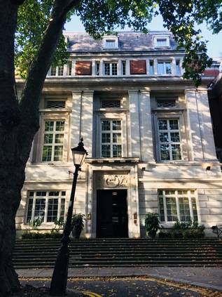
Finally at New River Head, the fringes of the city deserted as ever on a Sunday, I looked up at the grand former headquarters of the Metropolitan Water Board and the sleek modernist lines of the Laboratory Building beside it and figured that if unlikely schemes can be achieved anywhere in the world, London is probably the place. To bring fresh, clean water to this spot from distant Hertfordshire in a time when William Shakespeare - or the man who wrote the works attributed to him at least - was a living memory, was truly a remarkable feat. London changes, often not for the better, but is always remarkable. I shuffled off to find a way back to our hotel, wondering how my feet would feel in the cold light of tomorrow morning. I'd finally walked the New River as I'd long-promised - and the river had raised questions and new routes to walk along its entire length.
You can find a gallery with more images from the walk here.
Lost::MikeGTN
I've had a home on the web for more years than I care to remember, and a few kind souls persuade me it's worth persisting with keeping it updated. This current incarnation of the site is centred around the blog posts which began back in 1999 as 'the daylog' and continued through my travels and tribulations during the following years.
I don't get out and about nearly as much these days, but I do try to record significant events and trips for posterity. You may also have arrived here by following the trail to my former music blog Songs Heard On Fast Trains. That content is preserved here too.
