I hesitate to tag this as a 'London' post. It is marginal, in the shaded zones at the edge of the map. As this walk takes me further from the city, I start to look for an edge - the M25 is too obvious, and the city's gravity extends far beyond it into the vampiric region which sucks the economic life out of Southern England. Maybe the countryside that divides Essex from the London Boroughs? That almost non-existent band of greenery is all too easily missed - an overgrown car park of a decommissioned roadside pub readily mistaken for a nature reserve. The truth is, I don't have an easy edge against which to snap my definition - and if Southend Airport is now 'London' too, perhaps I should give up trying? Perhaps this whole esturial swathe is now London too? The glottally punctuated accents, the harsh tang of heavy metals in the air, the constant drone of tyre on tarmac - they are all London's trademarks - and they're with me as I walk. I was equally hesitant about picking up this project again after a pleasant festive season. It felt like last year's work - a snuffling away at the margins in an attempt to walk off the seething frustration of a year spent in limbo. It felt derivative - it had all been done by hardier souls with a better turn of phrase. Was there anything left to discover our here? All the shallow gangland burials unearthed decades ago, all the surprising vistas captured by photographers with lenses long enough to avoid actually visiting the edge lands. If today went to plan, I'd walk off some edges and into known unknowns - stations a mere half-hour from Fenchurch Street which felt desperately remote on foot. I needed to recalibrate my scale to understand how this journey, too short to read a book or hear an album on the rails, was a minor epic now I was walking.
Heading out to my starting point, I realised that I might have to rethink today's objective. Getting to Beckton isn't quick, and with the train lazily timed due to engineering I had a fairly late start. I rumbled around the Circle to Tower Hill, made a quick dash to Tower Gateway and settled into a DLR train which slowly but surely took me out of the city, past the recent history of my walks once again. It was years since I'd arrived at Beckton this way on an exploratory trip to cover the DLR. I remember feeling like it was some impossibly remote outpost - definitely not London back then. Since I've shaded in the territory between the city and the Alp this view has changed of course, but it still feels like an ending. The ski-jump of the unfinished ramp over Gallions Reach ascends to cross the tracks, its post-modern adornments which should have given entrance to a new river crossing blasted by wind and particulate matter. I start walking immediately and with perhaps a little too much enthusiasm. I need to get moving, pushing into the strengthening wind but mercifully dry so far. I turn north, the green slopes of the Alp ahead - and I feel almost guilty for not climbing it today. After all the strange symbolism I've invested in this artificial mound, it seems odd not to pay tribute. I pass by, climbing the on-ramp to the A13: boiling with traffic, the rare gaps between cars filled with spiral eddies of wind-borne dust. This isn't quite new territory yet - I'm passing the vast Sainsburys store I visited on my first trip out here, the road curves steadily around it, hugging the white sheds of the retail park. After skirting the connection with the North Circular nestled beside a Waste Transfer Station and steeped in the aroma of decaying vegetable matter, the road bucks and rises in front of me. A swathe of reeds and a slender curve of brown water below indicate approximately where the River Roding becomes Barking Creek and escapes the tightly walled channel it has followed from Ilford. Looking north, across six lanes of shrill white vans, I see the ponds and inlets of Cuckolds' Haven - another walk where I'd turned aside, unsure of my right to roam and cursing my reticence. From the shallow bridge, the flood relief barrier is barely visible as a huge turbine blocks the immediate view. Only the blast of cold, esturine air gives rumour of the Thames. Creekmouth spreads across the southern view - low-tech industry and scrap, the town of Barking tucked safely away to the north. The road stretches ahead somewhat uninvitingly in a concrete-walled trench. I wonder if this is a sensible plan after all?
The A13 is a dividing line here - north of the road is civilisation, with solid and reliable 1930s housing schemes butting up against the road, built for the future car owner with easy access to everywhere. South of the carriageway is the sliver of industry which skirts the marshy banks of the river. Abandoned power stations, rusting networks of de-purposed pipework, bored security guards who seem to have been forgotten by everyone except the payroll. They just keep turning up, crumbs on the regulation navy sweater, cap at an angle. Are they stopping me getting in - or out? I cross a footbridge to the northern path - mostly because I see a filling station with a sideline in coffee. I'm the only non-driver in the place. The assistant spits "No fuel?" disbelievingly before reluctantly scanning my Nectar card. I shelter next to a battered tump of greenery outside the garage to stash my purchases and shoulder my bag realising that there's really no provision for leaving the place on foot. Refuelled with the curious mix of caffeine and warm milk I increase my pace. I'm feeling a little post-viral, below par and wonder if I can really achieve quite what I've aimed for. Right now, it's good to be walking but I know I'll tire faster than usual. Walking into the wind doesn't help - my face feels raw and bitten, my knuckles turning from red to white and back. The road is relentless. The surface noise has a hypnotic regularity. I check my maps and note I'm edging onto the last page of the A-Z. There are no more of the comforting blue continuation markers on the right edge of the book. When I bought it, almost exactly twenty years ago I couldn't imagine who needed these maps of distant suburbia, so impossibly far from the core of things. Now I was about to leave the map and I felt a pang of anxiety. This wasn't going to be London at all.
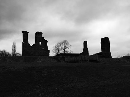
The road continues, still describing a shallow arc across the flat floodplain between the River Roding and Dagenham. The route is lined by a sound-repelling perspex fence as it begins to rise above the low blocks of housing on the northern edge. A green space opens out, stretching along the line of the railway which passes beneath the road but above the arrow-straight silvery line of Mayes Brook, heading south towards Barking Creek, encased in a narrow ribbon of green which extends along its route from the old A13 to this new interloper. North of here, the banks are reclaimed and offer a perimeter to the leisure zones of Mayesbrook Park, but this stretch is neglected by all but the most intrepid of dog walkers. This three-level crossing of routes marks something of a boundary. As I descend from the bridge, the first hint that walkers will be barred from the route at some future point are mooted by the signage. This is a temporary prohibition in fact, to account for the narrow and crumbling blue steel viaduct which carries a meagre few lanes of the A13 above the junction with Ripple Lane - its own earlier incarnation. The need to evade this junction is clear - aside from the flyover this is essentially a suburban roundabout - the northern flank surrounded by tired council dwellings and the southern given a view over the great Ford Motor Company water towers and wind turbines. Wedged into the triangle of land at the western edge of the junction is the Thatched House - a barricaded pub of currently uncertain status. Its vintage 'Double Diamond' sign still pitched on its high 1930s chimneys, the car-park off-limits and serving as overspill from the nearby junkyards. The whole place a grim and solemn roadside reminder of a convoluted, sorry past. The pub appears to remain a notable venue for African music and cuisine, but right now it is a dormant and oversized red brick behemoth of the type which adorned every well-planned municipal estate at first. A little further ahead, across the dual-carriageway, the Ship & Shovel presents another face of Dagenham nightlife - a displaced cottage style public house, oddly truncated and cluttered with unrelated vehicles. It looks as forlorn and menacing at the Thatched House, if a little less decommissioned. Edging around the traffic island and back onto the main route, I'm soon forced off onto an ancillary track. This appears to be the perimeter road of a new, tidy development of small family homes. At the end of the access road, I'm returned to the shuddering heave of the A13 as it passes Castle Green - a gloriously ungoverned tumble of green space fronting generous sports fields. As I draw nearer A series of curiously jumbled silhouettes on the flat grey sky resolve into local celebrities - inspiration for the pupils of the Jo Richardson Community School. Here on the edges of the city, the heroes are ultra-local in response to the reputation for non-integration. Casual racism was formalised into BNP council seats, and is now offset by naming public facilities after notably radical Socialist MPs. It's hard to know if it works - there's a metallic tang to the air here which reflects the sharpness of the knife-edge Dagenham sits on. There's a lingering sense it could collapse into either violence or utter indifference at any point as I navigate the slalom course of wind-toppled recycling bins which line the footway.
The path leaves the road here and skirts the pithily titled Dagenham Leisure Park. It appears in fact to be something of a relic - a former strip-mall of DIY retailers in the Midwestern vernacular, transplanted to the fringes of the old A13. With Lakeside now a short diesel-burn away, and with the main road curving away to the south on elegant stilts, only a cinema and a range of fast-food restaurants remain among the generous carparks. Footsore, lacking energy and desperate to use the facilities, I enter McDonalds. The monotone of the windy road is broken immediately by the screams of children, the cackling laughter of teenagers and the esturial admonishing of parents. It sounds hellish after the weirdly alluring swish of tyre on tarmac, but a cheap refuel beckons. I tough out the torture, pop painkillers and return to the road, my coat buttoned against the bitter wind. My road from here on is the A1306 - the redundant ghost of the old A13, fringing the residential edges of Dagenham as they break on the industrial foreshore. First though, there is a last knot of civilisation - a barricaded Indian Buffet restaurant which claims to be the 'largest', next to a much newer and far more capacious establishment which may well have caused this sorry end. There are mis-spelled signs and curious mash-ups of taxi office and take-away - but photography seems wrong here. I gorged on ruin-porn in those first few shuttered yards of Fieldgate Street. Here, away from the planning blight and regeneration schemes, it feels less edgy and more forlorn. Everyone should have to walk the mile from Dagenham to Rainham, across the Beam River and off the A-Z, before they critique local planners. It signifies the impossibility of making a community work by buildings alone. A little way from here sits Becontree, for many years the largest municipal housing scheme in Europe, radiating spurs and crescents of good, solid homes like an incomplete crosshair on the map. But here at the edges, it doesn't feel planned or controlled. It feels abandoned. Just before I cross the old A13 to head south I notice a new development with a street name which captures the mood: Passive Close.
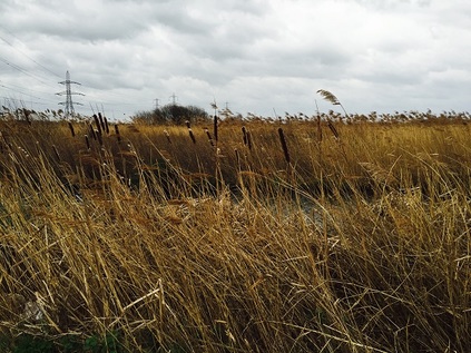
Bridge Road turns away from the road, towards a Tesco of epic proportions, crossing the reedy twist of the Ingrebourne River. I could head directly for the station here to end what has been a challenging first trek of the year, but the river interests me, and I want to see the marshes before I make a definite decision not to press on today. Three more miles? Surely I could manage that. Lamson Road is an industrial short-cut, taking traffic away from the town and along a dusty gully which parallels the river as it becomes Rainham Creek. The lack of development ahead means the dry, cold wind howls at me as I turn east. I'm chewing grit and sucking dust I don't dare to think about. At the next turn south onto Ferry Lane, an official footpath is signposted. I climb onto the ridge and the marshes open before me: a swaying plain of grass and pylons trapped between railway and road. To the south the elevated A13 severs the view, the heaps of landfill rising beyond. I set out a little way south along the path, still thinking that maybe I could cross the marshes today. A stylishly rusted iron signpost, digits and destinations marked by stamped-out sky-coloured absences, tells me it's almost four miles to Purfleet. I decide this is the spot to call this walk finished. I stand for a while, looking at the marshes and watching the High Speed trains flash by. I've been carrying a key to my parents' flat for years, but since the turn of the year I've been uncomfortably aware of it - a cold metallic pocket weight, linking me back to a year of anxiety and a place which is now just a memory. I'd always thought I'd go somewhere meaningful and memorable to ceremonially dispose of it - but I'm suddenly taken with the idea that this place is perfect. This seemingly endless swathe of bleak, open marsh where almost anything can - indeed has - been hidden. Somewhere things can disappear. A place without - and perhaps beyond - memory. I unlink the key from its ring and pause. Feeling the cold metal in my wind-dried hand, I wonder if this is such a good idea. To ditch the symbol in a spot which I'm sure I could never relocate exactly, and will probably never knowingly revisit? Of course it's perfect! I marshal my thoughts and before I can reason further, hurl the key as hard as I can into the sluggish reedbeds of the Common Watercourse. So hard in fact it almost reaches the clumps of tall grass on the other bank. But it's gone - beyond retrieval, the ripple signature settling into the still green mirror. The wind swirls and I see a party of walkers heading in from the marshes. I snatch a quick picture for posterity: grey clouds marching swiftly over an austere powerline panorama. A train from the continent roars by. It's time to turn for home, the unlikely ceremony complete and a long, difficult chapter closed.
You can find a gallery of images from the walk here.
The British Road Trip is a failed conceit - there's something about the maximum stretch of around 800 miles or perhaps the winding, hedge-bound roads which isn't given to epic journeys. While our edgelands have an intriguing character of their own, they're not littered with the Americana necessary to romanticise the road. Britain is best seen from a train window - framed and fleeting, glimpses of back gardens and sullen canal chasms. Brick and stone blurring at speed. I've tried the road trip before - an early nineties odyssey from the South West to Newcastle via North Wales, Liverpool and the lakes. It is a distant memory now, and not an easy one in some ways. But it set some important axioms: make the curve from West to East, break the journey on each leg and never ever consider Blackpool a stopping-off place. With these in mind, we contemplated our own winter journey - our first long-haul road trip and the first return to Scotland since 2013.
The first day was a long stretch, with a later than planned start due to some difficulties with the facilities at home. Once underway though, we made good progress and paused only briefly at the splendid, recently opened Gloucester Services. The cruise along the M5 was calm and surprisingly swift and we were soon entering the twisting viaduct section which winds around the suburbs of Birmingham and contemplating the switch to the M6 which stretches its legs into Staffordshire once free of the city. On an earlier trip this part had been a bottleneck, but not today - a New Year's day start had been an excellent choice it seems and we were soon cruising north into Cheshire. The scale of our challenge hit us at Knutsford Services - realising we still had some miles to cover to reach Cumbria, and trying to guess at how long the truncated winter light would last. We ploughed on, into dusk and then dark, navigating the gentle bulge of the Preston Bypass - the prototypical British motorway. The lights of tiny lakeland villages blurred in the rain spots on my window, and we flirted with the idea of a detour into Westmoreland Services, the senior sister venue to Gloucester and scene of a welcome breakfast on a previous visit. Instead we headed on, finally arriving in a wet but welcoming Penrith in time to check-in at our fantastic B&B before heading into town to eat at The George, reconnecting with my last stay here.
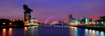
Day two saw us head out to Penrith Castle to walk in the damp misty morning, before setting off again for points north. The M6 became the A74(M) and we entered Scotland - a curiously emotional experience in some ways. Our last trip here had been challenging, fraught with adjustment challenges and difficult arrangements. This time, we were back and we were in charge of the itinerary. At Abington we branched off the motorway and enjoyed welcome coffee before taking the A702 along the floor of the Clyde Valley with the nascent river which had figured so largely in my past winding and carving through the soft ground. At Biggar, we left the river and headed into the rising ground and tiny villages of the Pentland Hills. It was a tortuous route, and surprisingly unreconstructed considering it's the logical choice for traffic from the south and west heading for the capital. Finally, around mid-afternoon after a testing drive, we started a descent towards Edinburgh. The dark stones of the city spread along the Firth of Forth, a distant cobalt streak with curious rock formations puncturing the horizon. Even I, sometimes dispassionate about this city, was forced to concede it's beauty as we snaked through the proud city buildings towards our hotel in the Grassmarket.
This proved to be a wonderful base - close to the old town and just a bridge away from the station and the grand squares and boulevards of the new town. Early on in the trip we realised that this might not be the optimum time to visit in some ways: Scotland takes it's double Bank Holiday at Hogmanay incredibly seriously! Once the rush of the holidays had abated, shops closed for an annual clean. The incredibly short days were swiftly drawn into darkness. This made for a strange and rather unreal feel. We'd wake on grey, misty mornings and sometimes barely see the sun. However in other ways the timing was perfect: the city shone in this pale winter sun - the grey stone of the buildings reflected the sheen of light, and the twinkling lights of the old town staggered crazily up the hill to the castle. It was beautiful if unnerving. I felt a little overwhelmed to be so oddly infatuated with Edinburgh after a taking such a definite position. This didn't lessen with the sudden, jarring impact of a trip to Glasgow after all these years. I felt like a support had been kicked away - but I was still standing, surprisingly finding solace in a late arrival back at Waverley.
Our time in Edinburgh was magical and too short - we ate a lot, and spent a lot of time inside pubs and restaurants given the weather and the short days. There was so much more to see - so much that would have benefited from a dry morning or one which didn't whip freezing winds along Leith Walk. We finally departed a little later than we'd planned via the old road - the A1, taking a sweep out east to the coast, then plotting a lonely course south through the barely inhabited border country. It was remarkably quiet out here - with few other cars troubling us, and occasional glimpses through the rocky scenery to the crashing waves of the North Sea around Oxwellmains. Again, darkness overtook us on Tyneside and we found ourselves in the carpark of a generic retail complex, resting and refreshing ourselves before we ploughed on towards York - and the beautiful old Great Northern Railway building which was our hotel for the evening. The holiday off-season had provided us with a remarkably good rate for accommodation we'd never normally afford, so we celebrated with excellent food - possibly the best I've ever eaten. It felt like a celebration of a tough year survived, of a long trip conquered. I felt properly relaxed, ready to face the new year but reluctant to return home.
The long run home through the East Midlands, curving across the southern edge of Birmingham and close to my home town seemed easy after the challenge of the A1 - and we seemed to be home sooner than expected. It was good to be back - but this felt like an important landmark - almost exactly 800 miles of travel on the routes I'd always wanted to cover when I thought of driving a car myself. Perhaps the great British road trip is possible after all?
I realised as we settled into the train at Waverley that I was nervous. It made absolutely no sense. I'd been looking forward to this part of the trip since we'd booked, and I'd been mulling over how it would pan out. We'd originally planned to drive over, but it didn't seem fair after the long haul up from home to impose more urban driving. Besides, I'd always arrived in Glasgow by train. As we crossed the ever-bleak landscape I've always loved between the two cities, I thought about previous arrivals and departures. It was fair to say that I'd normally done this in reverse, but on a few notable occasions I'd arrived at Queen Street to begin a trip. I found myself excitedly babbling about things seen from the windows, making odd connections, giving my apprehensive account of the city again. Soon we were dropping down, beside the barrel mound which surrounded the huge distillery, into the tunnel which would emerge in the city. I had a dry mouth, my heart was racing. This was absurd. It's Glasgow after all...
I suppose we adopt places at different times of our life, for different reasons. We cross paths with places at just the right moment for a redemption, a sense of home, just a place that's safe even? And often a place can evolve with us too, as London has always managed for me - and indeed, as Glasgow did for a few notable years. I'd invested a lot in the city - I'd ended up spending well over a month of each year here, seeing bands, exploring the city, trying to understand how it all fitted together. It couldn't be entirely coincidental that waves of the best music had tumbled out of this proud but ramshackle city that I also found oddly fitted me well? Later in my visits I'd started to explore Glasgow rather like I had London - striking out to find the source of things, visiting the often unvisited corners, walking further and more purposefully. Wanting to know and see, and maybe to understand. Then footsore and tired, I'd come back to the city for music and, as time wore on, friends of a sort. Of course, all this changed dramatically and excitingly for me a few years back, and since then there had been just one - not entirely successful - visit. I could chalk that up to culture shock, pushing too far and too fast, or maybe to the more sinister truth that I'd never found anyone who saw Glasgow quite how I did, let alone been able to explain my own feelings for the place or to convince anyone to see it quite how I did. I always worried what people thought of my affection for this often least-loveable of all cities, and I remember the crude assumptions people made about why I came here so often too. Sometimes though it's simple. It's the right place at the time it's most needed.
We stepped onto the concourse at the soon-to-be updated Queen Street station and like a giddy child I whirled around a bit for a moment, taking in the sweep of the roof. For want of what to do I suggested we visit an old haunt - Love Music, formerly Avalanche Records on Dundas Street. It all felt the same, smelt the same - the same fixtures and fittings. Alarmingly though, some of the same records were still here. Bands I'd championed back in 2011 languished in the 'local bands' section. There were a handful of new names, but few I recognised. Had I wasted my time entirely on all this, or had everything now retreated online completely? Where was the vibrant tumble of new sounds and mysterious discs I used to find on arrival? The fact was it took a great deal of energy to be nearly as up to date I'd managed to stay, and to expect to know without putting in the time was folly. For a while, it's fair to say, that my intense interest in the music here meant I usually had the good stuff before I arrived - but there was usually a gem or too lurking. I left empty handed and feeling thoughtful and we headed into George Square where a huge New Year's event was being dismantled - a far cry from the Thatcher Death Party we'd stumbled into on our last visit. From here, we grabbed a drink and then headed to Buchanan Street, passing the Yeeha Internet Cafe we'd had to lug our bags upstairs to use on a visit a few years back. Also, passing the coffee shop I'd so often frequented, especially when I'd just arrived and needed a bolt-hole until checking in time. Today there was no need to call in, no need to mark time watching the city. None of this made much sense really, so far out of context. We called into a couple of stores, shopped a little, wandered some more. The ground was wet, reflecting the silver sky back at us in the peculiar Glasgow way, and to the south the absence of buildings signified the river. It looked the same - but it just wasn't right somehow. I hadn't prepared for this - practically in terms of deciding what we should do, or emotionally - I was after all meeting an old friend having changed an awful lot in the interim. This needed thought. I felt exposed and clumsy, This had stopped being fun.
By Argyle Street I was finished. I'd no desire to go to The 13th Note despite it's place in my own history, I didn't want Glasgow to have changed, and I didn't want to admit I'd changed so much that I'd outgrown Glasgow either - even if that change was undeniably for the better in my case! For eighteen years I'd stalked this pattern of streets, watched the sun rise over Central Station or sink over the spires of the West End. I'd marvelled how you could buy a record from Stephen Pastel, get your hand stamped at a gig by Gerald Love or stumble into any number of musicians wherever you went. For a portion of that time I'd even lazily countenanced a future here - some way of restarting things 400 miles north when the opportunity came. Ultimately of course I'd changed my life in a far more radical sense, but I was aware that I'd somewhat closed the door on Glasgow too. It all became too much in M&S of all places... In a store which could have been anywhere in the UK, looking at generic menswear - I just knew that this wasn't going to work for Glasgow and I. It was time to leave.
I was persuaded to stick around for the train from Central back to Waverley - and it felt fitting to leave over the Clyde for old times' sake. To kill time we stopped into the Alston Bar & Beef under the station, in the catacombs which stand on the flagstones of old Grahamston. As soon as I saw the map of the long deleted district printed on their napkins I knew I'd be fine here, and that someone at least connected with things how I did. Good food, quiet and sanctuary while the rush hour clattered and swore above. We stuck it out until it was time to get the train, leaving under familiar signal gantries and over the dark river - recalling my desperate attempts to make a call to Seattle from a moving Pendolino three years before. Leaving the suburbs and plunging into the dark I settled back and reflected on the day, briefly surfacing at Carstairs to see the lights of the State Hospital. This had been a strange trip - an inversion of my usual loyalties - but a great one too. I guess I'd just changed more than I thought.
I'm not sure Glasgow belongs to me anymore, but a bit of me still belongs there. I don't know when or why I'll visit again - but I hope I get to, and I hope I get past this strange blockage in the process.
When I've mentioned that I'm curious to walk the A13, people have looked a little quizzically and asked, simply, why? I suppose they're used to my manifold topographical obsessions, complicated literary mash-ups and generally curious nature. Of course, roads were a very early interest - as a boy I'd scrawl imagined maps, but rather than pirate treasure they featured complicated interchanges, improvement schemes and Ministry of Transport approved signage. My interest in networks has never gone away - my railway obsession, the desire to map and understand London. However as a surprisingly - and perhaps given this interest, illogically - unlicensed driver, roads are a vicarious and distant pleasure. I recently began re-reading Iain Sinclair's "Dining On Stones" - a semi-mythologised walk out of the city via this route. Ten years later, with more exploration of my own under my belt the text made a great deal more sense. But it also posed questions about how the post-millennial fringes of London were changing, and how Essex and the city interacted. Sinclair's text is amusingly self-parodic, pitched somewhere between nostalgia and dystopia. That has actually always seemed a good measure for the little of the road I'd walked - and is perhaps a pretty good starting point for the whole of the British road network. A creation of the 1920s, these numbered and classified routes have drifted in and out of logic over the years as they have been re-routed, bypassed and decommissioned. Walking a road from origin to end-point seems a little out-of-character maybe? After all, much of it will be open country and far from the edgeland fringes and grimy city channels I seem to prosper in walking. But it feels like a project worth undertaking - simply because it's there to be walked. And so, on a blustery but strangely warm December morning, my trudge began...
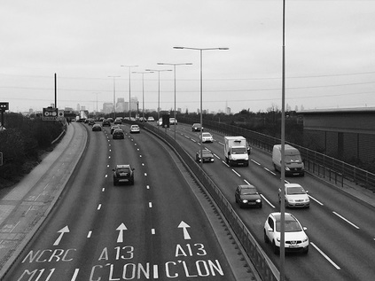
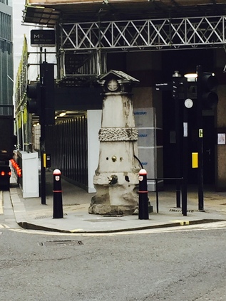
Setting out from Liverpool Street, I head through the fringe of the city and along the almost-deleted street of Houndsditch. The development encroaching on this ancient byway threatens to overwhelm it completely, hemming it in with tall towers. I make for the spire of St. Botolph Without Aldgate, once beleaguered by traffic but now subject to a public realm scheme which will create a pedestrian friendly approach. I pick my way around the works, noting how the wind has risen now I'm clear of the channel of office blocks - it's not a cold day, in fact it is perhaps oddly mild for early December, but the wind chills me. I grasp my cup tighter and navigate a little to the west to find Aldgate pump marooned between the arms of a junction and crumbling slightly. Some nonplussed and rather troubled looking Asian tourists regard the pump and the general area before snapping quickly, uncertain of what this monument represents, and retreating west. I take the opportunity for a picture - the official start of the A13 and therefore the embarkation point for this walk. It is an inauspicious, dirty and noisy start - the road east is a confusion of development sites, cranes set against a slate sky. Like always at the start of these wanders I doubt my purpose, doubt even my wisdom in being out here. But it's time to set off. I gently - and perhaps rather pointlessly - nestle my cup in the base of a now decommissioned litter bin and turn east. The A13 is a disputed route as many of the original roads designated in 1922 now are. There are some solid facts - it originates in the city and heads east, taking in Barking, Dagenham and the southern reaches of industrial, esturine Essex, before depositing daytrippers in Southend-on-sea. Officially it then presses on a little further to the shadowy Ministry of Defence bolthole at Shoeburyness, just a step away from the officially designated 'Danger Zone' of Foulness Island. Beyond London, the route is up for grabs. Once out of the confining grip of the city street pattern, it heads along a several-hundred year old alignment which served the docks, before turning a little north to provide the main drag of Canning Town. Here the first bypass starts - a swathe of much improved road takes the route a little south, ploughing through the previously empty industrial wastes towards a new crossing of the Roding. When I explain to locals that I'm walking the A13, they perhaps understandably ask "Which A13?"
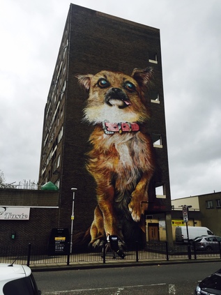
For now though the route is clear, and with Aldgate behind me I turn a little south and then east onto Commercial Road. This stretch of route is grim - an unrelenting parade of closed and shuttered shops on a Saturday morning. Some it seemed were aiming to make a feature of their distress - a little bit of imported Spitalfields glamour perhaps? Otherwise though, it was a mix of fried chicken emporia, sub-continental clothing retailers and student housing. The broad, empty road leads away from the city towards Limehouse, taking in some of the most contested territory in London. The most deprived wards of Tower Hamlets - indeed of the UK - crashing on the affluent beaches of Docklands. Mostly, it seems to work - the repurposed viaducts carrying the DLR serving as a firebreak across the Isle of Dogs, severing gloomy Blackwall and Poplar from the shining towers of light. As I discovered on an earlier walk, it's not easy to move between the mainland and the Isle - perhaps designedly so. First though, the tower of St. Anne's Church looms over the railway bridge, the road turning a little to circuit the northern fringe of the churchyard with its curious monuments. Beyond the church a tall tenement of dirty brick buildings claims to be a "VIP Garage". It very likely isn't. Crossing the canal, the road becomes East India Dock Road - a georgian thoroughfare which retains some of the fine townhouses which once lined both of its sides. Traffic is officially encouraged to leave the A13 here, taking Aspen Way and skirting the fringe of Canary Wharf on a road which seems to be neither public nor entirely private either. Sticking with the old route, the chill wind has finally challenged my coffee-filled bladder and I'm forced to leave the route, ducking into Chrisp Street Market. I've passed by many times but haven't really strayed far into the historic precinct. Historic because this humble concrete chasm leading to a purpose-built market square was the first such pedestrianised shopping area in the UK. Since its creation for the 1951 Festival of Britain, this pattern has been repeated endlessly and thoughtlessly over the British Isles, sometimes to terrible effect. Here though it worked - and it remains prosperous, inviting and has the sense of being a resolutely local spot which bears evidence of investment and renewal - including a fine new library building. There is a literal whiff of gentle gentrification - the range of ethnic food outlets in the Market participate in a regular Street Food fair for instance. The confusion of drifting smells from Chinese food, pie and mash and Indian cuisine purveyors signifies this might well be a good thing. I'm tempted to linger - but there is walking to be done. Leaving the market by the side entrance I'm confronted by the mass of Balfron Tower looming over the Brownfield Estate. Turning my back on it, I see it is defiantly opposed by a house-sized mural of a puppy - the kind of over-sentimentalised, big-eyed creation you'd see on a cheap birthday card. I leave the tower and the market's unlikely guardian to their own devices.
Back on the A13, the northern fringe of the road is also the perimeter of the Lansbury Estate, with generous green spaces and local facilities evidently still functioning. This is the kind of philanthropic planning which the nation cries out for often, but rarely gets - and certainly not here. Now, along with Chrisp Street, managed by the slightly shadowy Poplar HARCA it soon peters out into a mess of projects on former public land: half-built towers and empty spaces with hoardings proclaiming future opportunities. Between these, businesses still sell fast food, SIM cards and tyres or front mysterious travel money operations. Suddenly, and noisily, the scene opens up as the Blackwall Tunnel Approach Road dives under the A13, the tunnel portals visible to the South. Looking north there is a strangely compelling view of Balfron Tower and distant Stratford with the ludicrous Orbit standing out from the former marshes. I take a wrong turn, coming to a dead end in a swirl of dry leaves and litter. Retracing my steps, I halt in the middle of the mess of footbridges crossing the tunnel approach to capture views north and south. The road is breathtaking in it's sweep and severity, and my onward route here is decidedly the minor player. The once proud road to the docks usurped by the north-to-south torrent of commuters and shoppers. The road is swiftly closed in again, hemmed between more new hazily public-private development and the grey prison fascia of the Docklands Travelodge. Tucked between here and the river, straddling the former East India Dock, is the Mulberry Place headquarters of Tower Hamlets Borough Council - expensively leased since 1993, with an equally profligate move to the former Royal London Hospital planned. The area is carefully managed to be as banal and inconsequential as possible, reflecting the strange belief that a deserted place is more secure than a busy, civic centre. I take a turn away from the main road here, following the dock wall which divides the carriageways of Leamouth Road. I know there is a strangely isolated service station at Orchard Wharf which provides an opportunity for sustenance beside Bow Creek. As I turn south a squall of wind stops me in my tracks. A mix of building dust and silt covers me, my sweater sparkling with silica and a salt grind between my teeth. I adopt a crabwise shuffle to edge around the open entrance of another new development of rental towers from which the dust seems to originate, and cross the street to find the garage. But it is gone. The windows boarded, the forecourt a screed of stones. The building looks oddly forlorn, swept by river winds and blasted by sand it is already peeling and crumbling. Still surprised, I retrace my steps towards the road. Change here is swift and absolute it seems.
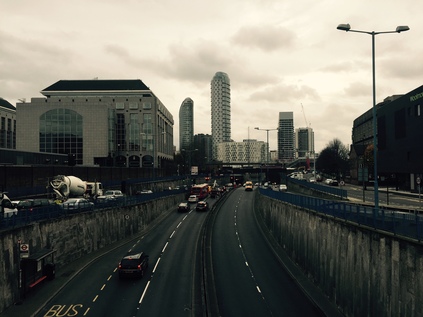
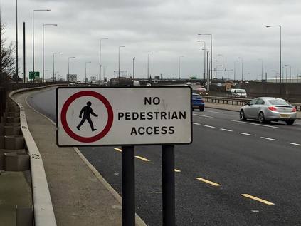
Re-crossing at the confusion of lights at Leamouth Interchange, I'm struck by an odd sight: the new Lighterman's Point development towering above is fringed by a street of fine old terraced houses, diving off at an oblique angle and defiantly refusing to be part of the new zone. Aberfeldy Village isn't new - this colony beside the creek has co-existed, indeed been co-dependent on the dirty, industrial fringe of the River Lea for generations. Its new guise sounds more like a drug-trial than a locale - but we're reassured that 'AV-E14' is importantly not regeneration. That's a filthy and devalued term here in the Lower Lea Valley. This is reshaping, re-imagining even. I'm confused and confounded by this however: London has a terrifying housing problem. It needs a mix of accommodation and it needs it fast. These old, solid family homes are being replaced by blocks of student housing, one bed luxury apartments which house couples at best, ground-floor retail units for a zone with no centre. The line of proud, tidy houses are surely an essential part of the mix? Absent-mindedly picking this over, I climb the curve of the bridge which takes the A13 over the intestinal curl of the Lea. I can be in no doubt what road I'm on - all three lanes are proclaimed A13 by the overhead gantry. The views south are occluded by the road, but looking north I see the forbidden edges of the river where no path is available. The curves and bridges are familiar, well worn, often revisited. Landmarks stud the scene - remembered tower blocks at West Ham, the cluster of silvery columns of Stratford City, the ever present and never welcome Orbit. Descending from the bridge is leaving 'London' in some ways, heading out to the marshes. The road divides, the old route becoming Barking Road and dividing Canning Town with a mix of over-familiar high street names and local colour, while the new road is a non-pedestrian flyover snaking above the streets. I shop for food before rejoining the route as the bridge touches down. The pattern from here on is set: a broad cycleway and pavement set alongside the northern edge of the six-lane road. I pause to eat at a local exit for Prince Regent, sitting on the concrete podium of a telephone switch box. The old streets intersect the new at strange angles, the rooftops of Victorian terraces coming to a sudden, premature halt where the new road gouges through long-established districts. I set off again, and realise I'm getting strange looks and creating interest in passing drivers. It's perhaps not surprising - I'm a wild-haired, heavily bearded walker in a sweater and rucksack despite the December cold, and by far the only pedestrian for miles. Even the occasional cyclists look askance. Then it becomes clearer - the high fence and cameras fringing the bank beside me belong to the Newham Centre for Mental Health. I'm an assumed escapee. As I suck fumes and regard the featureless view ahead, I wonder if they're not right?
It is entirely a myth that traffic thunders. Out here at least, the sound of the stream of passing vehicles is a endless and metallic, ululating drone. On another day, in the peak hour, it might almost be silent - a string of unmoving red tail lights stretching back to the city. But on a December Saturday the cars flow steadily, punctuated by occasional business vans - their drivers pressing 'phones to their ears and chewing on thick hunks of sandwich as they shuffle lanes testily to gain a little on the cars doing strictly the correct speed. Here, as the gravity of the city weakens, the road speeds up. Hamstrung until now by a low speed limit which makes a mockery of its quality engineering, the A13 makes a curve north, skirting Beckton's retail parks and low-rise housing schemes. Of course the original route swevered too - dodging the swathe of industry between here and the River Roding and the vast gas and sewage metropolis which filled the alluvial flats between here and the docks. In the middle distance as I round the curve, the road bucks and weaves to the left. Beside the ramps of the next grade-separation is a tump of green, wooded but with a bald and exposed top. Beckton Alp, seen from this direction at least, is impressively elevated in an otherwise level plain. The iron palings which edge the summit freshly blackened and adorned with new graffiti: All power to all people. Denuded of foliage by the season, I see a white-coated dog walker make the summit and stand for awhile, companion capering around - a distant flickering stick-animal. I cross the A13 by the footbridge, towering high over the six lanes of chaos and challenge below: cars fence for position, forcefully occupying the space just left by others as they weave, looking for some tiny perceived advantage or realising too late they need the exit. I resolve to get all the way to the top this time.
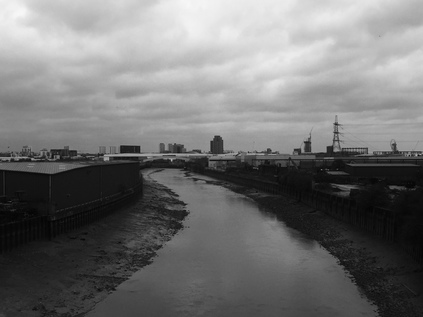
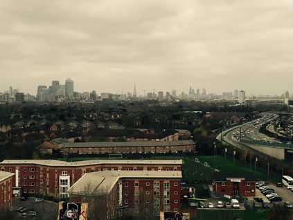
The entrance to the Alp is much as I found it last time - an anonymous metal gate with a businesslike padlock attached to a drawn back hasp. My fear that this would be deployed during my visit was unfounded, and this time I'm less concerned. I enter the gateway and start to ascend, zig-zagging back and forth and dodging the inventory of what appears to be a small colony of nocturnal inhabitants: Polish lager cans, discarded jeans, extinguished fire-pits, condoms. The path is cracked and fissured by tenacious bramble stalks reaching for sunlight. It's easier going in Winter though, with the overhanging foliage and colonies of midges absent. I see the dog walker below, leaving by the other gate and decide it's time to make my own assault on the summit. As I reach the end of the official pathway I see a gap in the fence where the bars have been bent apart like a cartoon jailbreak. I size up the gap - it's pretty big, but then so am I. I pass a leg through, stoop and swerve to get my rucksack under the bar, then I drag a second leg through and I'm on the other side. The reason this area is gated off is immediately apparent: to my right is a decaying wooden platform dating back to the ski-slope endeavour. It is clearly a pretty risky structure, and only a complicated insurance claim could follow any attempted use of it. Looking left up the slope however there is a well-worn track which curves slightly towards the summit. A quick scramble, assailed by the wind gusting in from the estuary, and I'm at the top. Suddenly all of London is before me. It was impressive from below, but here, unhindered by the trees it is magnificent. Ever present, east and west, is the snaking A13 - a ribbon of dim lights in the increasingly gloomy afternoon. Looking south, the sugar factory at Silvertown towers about the low rooftops of North Woolwich, and beyond is the glowering rise of the Kent coast. Looking east, following the road, is a maze of warehouses and retail hangars between here and Barking - all clad in the same corrugated shells, as white as the goods they are peddling. The flood barrier casts a shadow over the brown snake of the River Roding, and beyond? Well that's where I'm heading...
Descending from the Alp I catch a bag strap on the fence leaving it mildly distressed, but perhaps surprisingly I note it doesn't worry me. I'm aware I've been in a near constant state of activation for months - anticipatory, dry-lipped anxiety has become the everyday state. The mess of finances and legalities has begun to seek a proxy in other, worldly concerns and a bit of mild rucksack damage would normally feel insurmountably challenging. Like an overtightened cello string, I've involuntarily vibrated to the noises around me. Oddly though - and I can't stress how rational I usually am, or how ludicrous this sounds - I feel like I've left something up there in the wind, swirling off into Essex. I start homeward by picking through a retail zone unusually carelessly. I'd normally be concious of my oddness, my separateness from the line of consumers' cars. Attracting attention by trying too assiduously to avoid it. Soon, I'm treading an old railway path cutting diagonally towards the docks. The wind swirls litter and autumn leaves across my path. I'm starting the long journey home feeling oddly calm.
You can find a gallery of images from the walk here.
Lost::MikeGTN
I've had a home on the web for more years than I care to remember, and a few kind souls persuade me it's worth persisting with keeping it updated. This current incarnation of the site is centred around the blog posts which began back in 1999 as 'the daylog' and continued through my travels and tribulations during the following years.
I don't get out and about nearly as much these days, but I do try to record significant events and trips for posterity. You may also have arrived here by following the trail to my former music blog Songs Heard On Fast Trains. That content is preserved here too.
