London's Other Orbitals: The A5109 & A109 - A Middlesex Arc
Posted in London on Saturday 2nd December 2017 at 11:12pm
When I wrote a somewhat belated introduction to my series of London's Other Orbital walks, I perhaps played down just how obsessively fascinated with roads I was as a child. For a chubby, shy and relentlessly bullied boy from the Midlands, getting home from school and being able to pore over maps of blue, red and green lines snaking over the country was my escape. The journey home itself was a fantasy world of civil engineering projects and complex interchanges, as I imagined each side-path into a housing estate as a motorway junction along my walk. I drew endless networks - sometimes imaginary, sometimes improvements to the tangled and congested junctions on the maps. I internalised an intimate understanding of the complex and sometimes apparently arbitrary numbering system which had landed on the maps in 1922 and had almost immediately been littered with exceptions and compromises. In short, I was a strange and introverted boy who preferred the company of maps to other people. To some extent, I'm just a slightly better socially-adjusted version of that same youngster nowadays. The gift of a map is always a delight as friends and family know - but they can then expect to lose me for hours. When I finally moved the last of my possessions out of my parents home in preparation for its sale, I uncovered a stash of ageing maps: huge single-sheet Bartholomew road maps were tucked into the queasy golden-brown cover of an early 1970s AA Book of the Road, with its magical strip-maps of motorways, some represented by thick dashed lines and still yet to be built. Indeed, some never were built. Growing up to be a non-driver isn't, as many who offer me unwanted advice seem to assume, a great source of regret - I truly haven't the right skills to do it safely or without undue stress - but it does mean that my experience of the road network is a little different. Writing about the routes which slink across London, between the mighty arterials which pulse traffic into the city's core, has been revelatory: I've simultaneously discovered how well I know the suburbs and how little I know of them. When arriving at a familiar junction from a new direction, the world fits together a little better, but new arms on the sign become fresh mysteries.
Why the introspection? This is likely the last of these proto-orbitals north of the Thames. There are other roads to walk, and I hope to get to those on future trips, but none of them conforms to the admittedly loose brief I set myself with this project. Indeed this walk was a little contrived in itself - the A5109 and the A109 have never really been one route - but there is some evidence that this arc of tarmac which starts at Mill Hill and manages to break out of the gravity of urban London before descending from the heights into the Lea Valley at Edmonton has been used to skirt the northern suburbs for time immemorial. It has the well-worn feel of a country lane for much of its length - a road which has always been there perhaps? It certainly begins its journey on an ancient trackway - and I began my walk there too, under threatening grey skies at the crossroads where Edgware straddles the venerable course of Watling Street on its journey from Dover to Anglesey. The modern junction is a textbook London suburban centre - a vast mid-century pub, The Masons Arms, takes up an entire corner while a range of red-brick shopfronts and a run of mock-Tudor cottages heads north. The businesses on this busy intersection are low-key, unloved and apparently not well-patronised on Saturday mornings. I turned south on the A5, enjoying the surprisingly long view offered by the altitude and the straight carriageway. Modern Edgware, away from the bustle of its small urban centre at least, is a little grey and down-at-heel. The road is flanked by uninhabited office blocks, business centres and building suppliers, a landscape without people - which makes those walking beside the road strange and threatening. It's not hard to fit this into the narrative of Dick Turpin, the celebrated highwayman who was perhaps not the heroic character which has been passed through the purifying flame of nostalgia - his gang's raid on Earlsbury Farm in Edgware in February 1735 saw Joseph Lawrence, a man of seventy, tortured, stripped and burned while his servant girl was raped. Edgware still feels like the place where a blind eye would be turned, where people would thank their lucky stars it wasn't them and hurry away. This may be uncharitable - but trudging along the lonely and brooding dark channel of the A5 did not inspire much faith in humanity today.
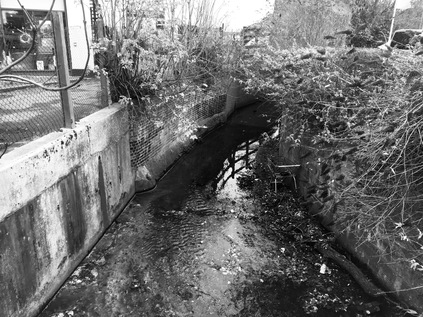
This short stretch of Watling Street did however take me over the Edgware Brook, a filthy and rather noisome stream which curved under the road in a concrete culvert near to the junction where the A5109 turned east - and where my walk began in earnest. The rise of the road as I headed into the suburbs indicated that I was heading for the higher ground where the headwaters of the River Brent rise and that I'd be crossing numerous tributaries which snaked together to form the Silk Stream and the Dollis Brook, converging at a point I'd passed on a previous walk. It was hard to read this suburban climb as an A-road at all as it slowly ambled between pleasant inter-war semi-detached homes. Deansbrook Road rose gently towards the bridge which carries it above the Northern Line on its final stretch towards Edgware and the watercourse for which it is named. The Deans Brook rises on the high ground of Scratch Wood, taking in the waters of the Edgwarebury Brook, the Edgware Brook and the Burnt Oak Brook before becoming the Silk Stream near Burnt Oak Station. A footpath descended to snake briefly alongside the brook before passing between the houses below, but it wouldn't have taken me further along my route. Instead, I followed the road to its first junction, an unremarkable suburban roundabout where it turned illogically north to skirt the edge of Mill Hill. The road climbed again and began to curve towards the east, with the impressive hulk of John Keble Church gradually revealed ahead - first the golden brick of the tower, then the stepping bulk of its nave. Designed by D.F.Martin-Smith, the church was consecrated in 1936 and Grade II listed in 1989, the slender louvred tower dominated the view uphill with Keble's name inscribed in stone above a stylised eagle - emblematic of a poem in his Christian Year. Reportedly, this is the only church dedicated to Keble, the humble but influential poet-vicar who formed part of the Oxford Movement. It sits on this rather inconsequential spot, a formative step in modern church building. In 1958, Martin-Smith, then in partnership with Henry Braddock went on to build the swooping brick and concrete St. Mary's in Crawley - a more ambitious and challenging building, but perhaps one that sits less comfortably in its surroundings than this arresting hilltop structure?
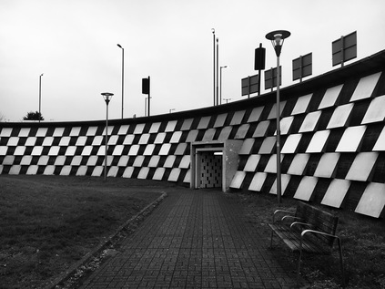
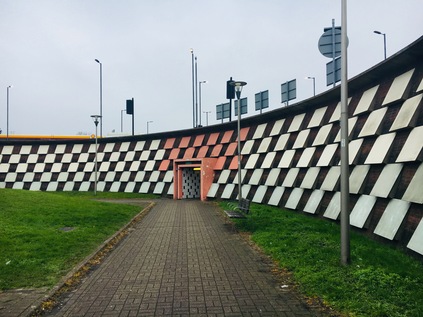
The road continued to head northeast, passing through the rather drab shopping zone at The Hale - one of the several knots of urban life which make up Mill Hill. There is no real centre to this suburb, in part due to the haphazard railway development which saw a single-track line from Finsbury Park to Edgware opening in 1867 with the plan to expand when traffic grew. In the event, the High Barnet branch was much more profitable and the second track was never laid. The line languished on with a shuttle service to Finchley until 1935 when the London Passenger Transport Board's New Works Programme proposed to link the suburban lines from Finsbury Park into the Northern Line and to use a long-established right to build rails beyond Edgware to Bushey Heath. The complex web of Northern Heights lines would thus feed into the branches of the Northern Line, and would link the suburbs to the city - but the war intervened, and little was achieved beyond electrification to Mill Hill East. The line beyond this was abandoned and now provides a TfL supplies depot, a nature reserve and an intermittent and somewhat forlorn greenway between Edgware and Mill Hill. Beyond The Hale, the road climbed steadily to another of Mill Hill's scattered urban loci at Apex Corner. The origin of the curious name for this spot appears lost in history, but likely refers to its relative elevation and the meeting of the roads to Watford and Barnet. The modern incarnation of the junction sees the A1 and A41 sweep in from the south as a single, wide road before dividing at the roundabout and heading in their respective directions. Meanwhile, just feet from the roundabout and entirely disconnected from this earlier incarnation of the trunk road network, the M1 thunders in a cutting alongside the Midland Mainline to St. Pancras. By the early 1960s, the junction had acquired its current configuration, swirling around a sunken pedestrian area with a tiled bank of chequerboard stone raking up to the road and solid stone portals providing access to the radiating footways. At some point, Apex Corner must have been a busier spot for walkers, but now the junction is a bleak prospect on foot. While one corner retains a typical suburban retail parade now operating the ubiquitous mix of betting, tanning and eating establishments, housing has largely encroached elsewhere. But on the northern flank, between the arms of the roundabout which stretch out to Watford and points north, a drive-thru KFC and a Shell filling station provide necessary services to those who are sticking to the old routes. Apex Corner is the ghost of a staging post on the road north, and while traffic rumbles north on the nearby motorway, this oddly bleak circus sits on its hilltop looking beyond London.
My route was briefly with the A1, before the A5109 turned northeast at an awkward afterthought of a divergence, necessitating traffic skittling across the central reservation after being freed of the gravity of Apex Corner. The main road continued north, a silvery ribbon of tarmac heading out of the suburbs and rising into the greenbelt which curtailed London, allowing the green spaces of Scratch Wood and Moat Mount to remain undeveloped. The scene reminded me of the vintage 1980s logo adopted by the London Borough of Barnet, featuring a sweep of dual-carriageway snaking around oversized trees. The woods here were once threatened by the semi-mythical Stirling Corner Link - a road joining the M1 and the A1, and the first chance for northbound traffic to leave the motorway at Junction 3. This junction was never completed, with three-quarters of a roundabout forming awkward access to London Gateway Services instead. The road, if built, would have carved through the top of Scratch Wood, sending sliproads arcing over the A1 and descending into Thistle Wood in at least one version of the scheme. The planned Junction 3 was part of the 1961 plan for the M1 which had it ploughing on to Marble Arch, unhindered by anything in its path. The more modest Hendon Urban Motorway opened in 1967 without Junction 3 and sputtered to a premature halt near Fiveways Corner rather than relentlessly progressing into the West End. Various references in the National Archives to soil slippage at Scratchwood and expensive remedies needed for shifting concrete walls along this section of the route may give a clue to why this was the case. However, the plans remained resolutely part of the future development of the motorway until being quietly shelved in the straightened public spending round of 1976. The link road concept has resurfaced at times, not least in 1989 as part of the Roads for Prosperity plans - getting as far as an invitation for prospective builders to tender on that occasion. But in 1994, the plan was finally killed for good, and the services continue to delight in the most bizarre and confusing access routes in the land. The green spaces remain, quiet and undisturbed - at least for now...and I was soon to find myself practically out in the country, despite being firmly within the confines of Greater London.
There was a distinct shift as the road climbed Highwood Hill - suburban semis became large villas and gated dwellings of impressive scale, and the cars outside properties were newer and far fancier. At the peak of this first climb, the pavement switched sides, the first of a number of times I'd need to cross the A5109 as it became essentially a country lane. This rural byway however saw traffic at North London speeds and densities and even had a regular service of red double-decker buses. This was an indication that my sloppy categorisation had been accurate - this was an orbital route in the same way that some of its more impressively proportioned relatives further south were being used - the most direct route from somewhere to somewhere else, even if not the officially sanctioned means of crossing London. Satellite navigation has changed behaviour here, and the most direct route is suddenly open to even those who don't know the terrain. You can detect them - barrelling into corners and shifting gears erratically to scale hills, but utterly unaware of what lies beyond. They trust the instincts of the machine, and mostly it works out for them - and so they continue until they're let down by the technology in some dead-end. Even then, they'll usually allow the algorithm to re-route them out of trouble. Highwood Hill was an exclusive address as early as 1825 when Sir Stamford Raffles, fresh from his colonial exploits in Singapore and the Far East returned to live out his last days here. While Raffles was a proponent of colonial reform, his ideas were perhaps not entirely in tune with the great reformer and supporter of emancipation William Wilberforce, who retired to his own property nearby just a year later. In declining health and having retired from Parliament, he survived long enough to see his campaigning result in the final Commons reading of the Abolition of Slavery Act in 1833. At the crest of the hill, between the sites of these two gentlemen of the Regency era, Nan Clark's Lane leads north into the fields - marking a final retreat of an entirely other nature. Nan Clark was a barmaid in The Rising Sun with many admirers but wed to an exceptionally jealous husband. When rumours of an affair reached him, he is reputed to have dragged her by the hair along the lane to a lake where he drowned her in front of a horrified audience who had followed them from Highwood Hill. The legend has spawned a range of stories of supernatural goings-on which are sadly the only record of Nan Clark now. Fuelled by the presence of the lane and with The Rising Sun still trading nearby the legend is a popular local ghost tale that adds a slight frisson of the rural English gothic to the estate agents patter when they're flogging property on the overheated market in NW7.
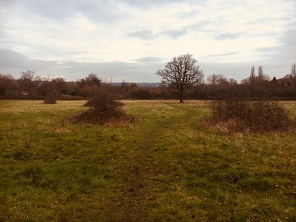
Shortly after reaching the peak of the hill both pavements gave up completely, the road narrowing and curving menacingly into the next rise. Relying on my map, I headed through a gate and into Totteridge Fields. This local nature reserve is perhaps not at its best in December, but the faint sunshine and the glorious sweep of ungoverned green was a welcome relief from the road. I squelched diagonally across the former hay-fields, which narrowly escaped conversion into a cemetery in the early 1990s and which are now leased by Barnet Council to the London Wildlife Trust. Aside from a well-kept information board and some sturdy kissing gates, they've left the land to run wild and the desire-line I followed was ghosted by the skeletons of autumnal weeds and wildflowers bending in the breeze. At the edge of the field, I crossed a tiny brook by way of a wooden bridge, realising that this was one of the barely trickling sources of the River Brent which had seemed such a broad and mighty presence on my last walk. Here I could press onwards to find the London Loop which meandered along with the nascent Dollis Brook nearby, or I could double back towards Totteridge and the road. I felt duty-bound to do the latter, and after scrambling over a muddy stile worked my way up an indistinct footpath lined with frequent dire warnings not to stray. The waterlogged scramble eventually brought me to a drive between two impressive farmhouses, and then back to the road. This was Totteridge - a long, straggling village set in former Manorial lands now in trust to a private association. Each house, set back and discreetly screened from the road, bore its name on a curved, white painted stake on the road. A footpath was tolerated but often ill-kept and ruptured by ancient roots. No-one walked this stretch - it was too important to be seen in the right kind of motor car, cruising by the long ponds which lined the southern flank of the road. Nothing interesting was happening here, and everything was just so - the Manor's groundskeepers ensuring that the carefully preserved and jealously guarded lack of event was undisturbed. The scenery was green and pleasant, but I must confess utterly dull and surprisingly charmless. The road curved and descended a little towards the Dollis Valley and a few fellow walkers appeared, surveying my muddy and leaf-caked boots with disdain and alarm. They headed for The Orange Tree, a vast rural pub with a well-stocked car park and an enviable menu of gastropub delights near the edge of Totteridge. Eventually, at the foot of the hill, I found the anonymous parapet where the Dollis Brook headed under the road on route to Welsh Harp. The footpath into Whetstone Stray, alongside the churning waters which had already gathered some surprising pace and width since I'd seen their tiny tributary a mile or so back, was tempting - but the road needed to be walked to its conclusion. Up ahead, the A5109 shuddered to a halt at a staggered crossroads not far from Totteridge and Whetstone station. This little knot of urban normality felt like a relief after the forced conservation of Totteridge. As I navigated around an angrily accelerating driver who was hot on my heels as I completed my crossing of the road, I didn't spot the Whetstone until I had passed by. This stone of unknown origin appears to have been used as a mounting block beside the tollgate which controlled access to the Whetstone and Highgate Turnpike here until 1863.
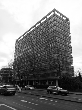
On the corner where the A5109 meets the former Great North Road stood Eveready House - now known as Barnet House, a strikingly modern block built in 1966 by Richard Seifert for the British arm of the Eveready battery company. Gravity-defyingly bulky, the building stands on pleasingly solid-looking stilts above the ground. Seifert's almost impossibly prolific output in London alone produced such a mix of wonderful, terrible and downright ordinary buildings that it is hard to approach preservation of his heritage - however, as the building was adopted by Barnet Council in 1986 its recent fortunes have remained fairly assured. It is difficult to imagine how such a substantial block this far out of the city could survive for long without this public patronage, however. My next stretch of road departed the former A1 route directly opposite the building, the surprising suburban bulk glowering over the rather innocuous beginning of the A109. This road has always been numbered thus, unlike the A5109 which was until the 1940s a lowly B-road - but it has a sort of deferential air, giving way to other roads and allowing them precedence at junctions. The A109 comes into its own for just the kind of local in-the-know traveller I've talked about before - for whom the journey across and within the city is more important than simply getting to or from London. The village centre of Whetstone clung to the road for a spell, allowing me to find some much-needed sustenance - it had been quite a hike up from Edgware and I was wondering if I'd set myself a challenging walk in the time available today. I rested briefly on a damp bench among a disarmingly constant stream of pedestrians - it felt like I'd been largely alone for much of the morning, and needing to weave around people was an odd new feeling. I set off again, heading downhill now with surprisingly good views to the east. This was the largely unremarked suburb of Oakleigh Park, lining the route with pleasant, suburban homes which for a decade from 1941 housed a secret listening station for the Soviet news agency, TASS. The plug appeared to be pulled by the Security Services in 1951, but only after Barnet Council had unsuccessfully tried to close the station on planning grounds. The road continued south, bridging the railway at an awkward angle before running alongside it towards the city. The sliver of land to the west of the road was hemmed in by the tracks, and when it finally became broad enough to be useful hosted a string of industrial units and building suppliers. The road was quiet here - there are lots of better ways of getting across town nearby and the A109 is left to its rather forlorn own devices. Only buses and the occasional white van heading for one of the local businesses passed me as I trudged on into a purple, brooding sky. It felt like the night was already encroaching and I fell into a reflective frame of mind as I walked south, thinking about how this route was now converging with other walks: the valley of Pymmes Brook ran parallel close by to the east, and I was once again converging with the North Circular on its relentless arc. These northern zones which once seemed so unreadably vast and dull were becoming strikingly familiar in parts but still maintained a capacity to surprise me with a sudden view or diversion.
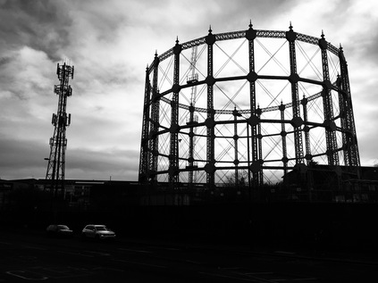
The A109 began to climb again near New Southgate Recreation Ground, part of a swathe of green space which stretched north to the Pymmes Brook valley and Brunswick Park, crossing the spoked wheel arrangement of the cemetery. This site - then known as the Great Northern Cemetery - would have been the first to offer cremation in the UK in 1861 had the Bishop of Rochester in whose diocese large parts of suburban North London still sat, not replied that he had neither the will "nor the power to allow such a mode of disposal of the bodies of the dead". The Cremation Society persisted in its efforts, and finally, the first cremation of the modern era took place in 1885. The Cremation Act followed, passed in 1902 to authorise burial authorities to establish crematoria but also to outlaw open pyres like that used by the self-ordained Druid Dr. William Price to dispose of the body of a child fathered to his housekeeper. At the peak of the rise, the A109 again deferred to other roads at the oddly named Betstyle Circus. This little urban cluster in the suburbs seems confused - either masquerading as Friern Barnet or New Southgate and with the boroughs of Barnet and Enfield erratically switching territory around the spokes of the roundabout. My route unexpectedly took the easterly exit here, before swiftly turning south again to pass by New Southgate station. Across the rails and above the trees the impressive buildings of Friern Hospital could be seen, formerly the Middlesex County Asylum and now an exclusive housing complex. The boundary of the boroughs edged along the railway here, with the road falling into step beside both until it dog-legged to the east to skirt the site of the former New Southgate Gasworks, now given over to a vast builders trade supply business which sat atop the arches of the railway siding which once served the site. The single remaining gasholder reminded me I was approaching the North Circular once again, and encountering a familiar view from a different direction. A new development of apartments was slowly rising beside the pavement here, wedged into the corner created by the A109 and the Bounds Green Brook. The hiss and shudder of the busiest road I'd encountered since leaving Edgware was evident before I could even see it stretching along the valley floor, bisecting my onward route which climbed the valley ahead of me. I had no business with the A406 today, but I did need to cross the six lanes of traffic here. The crossing had an entirely different impact approaching from the north, and the road felt more like an imposition on the landscape from this aspect. As I waited for the lights to change, the sole pedestrian in sight I supposed, I noted a small group huddled on the central island. Occasionally when a stream of traffic braked hard for a red light, they would groan and rise, tottering at first on uncertain legs, before working the stream of cars. Some, the most downtrodden and disabled among them, would beg in the most direct sense. Meanwhile, a more enterprising younger man in a hi-vis vest he'd probably retrieved from the verge of the road sold multipack cans of Diet Coke and bottles of water from a shopping basket. This probably worked well in a summer traffic jam, but on a grim December afternoon when snow threatened, drivers seemed less inclined to buy. As the lights changed and I crossed, the forlorn group repositioned to ply the next queue of traffic. I hadn't noticed these people when I made my way along the North Circular. Had they been there, and my onward focus too unwavering to miss them? Or had they been obscured by others using the crossing that day? For all that's said about my introversion and self-absorption - especially when I'm walking - I'd hope that I wouldn't have overlooked such a sorry scene taking place in the midst of this unsheltered tarmac plain? I completed my crossing and began walking up the hill which climbed out of the valley of the Bounds Green Brook. Looking back, the figures were only barely visible, scuttling and hobbling towards cars in a display of surprising optimism each time the lights changed.
It was possible to walk along a surprisingly broad area of green space beside Bounds Green Road, which rather reminded me of its appearance on early maps of Middlesex as a country lane in a wooded channel between the fields. Suburbia had encroached by the late 19th century, with Wood Green sprawling inexorably towards Southgate as Londoners moved out of the city along the railways. Bounds Green however seems to have stayed surprisingly upmarket, with many fine old houses ranged along the terraces beside the road. Not all remains of course, and around the twin brick towers of Newbury House and Finsbury House is a small estate of modern, low-rise housing which feels a little unloved and in need of refurbishment. Nearby, in surprising contrast is the red-brick and white stone Braemar Avenue Baptist Church, an unusually decorative approach to a non-conformist chapel and a reminder that Wood Green and Tottenham were hotbeds of religious dissent. The congregation relocated to this fine building in 1907, having previously assembled in a range of homes and halls across the area. I'd encountered the church during my walk along the New River Path, and I soon crossed the route of the river's tunnel which meant I was closing in on Wood Green. One last surprise before I plunged into the urban maelstrom of 'The Mall' was the obelisk dedicated to Mrs Catherine Smithies which sits on a patch of ground outside a rather gentrified run of shops and pubs. Smithies was responsible for the formation of the Band of Mercy - an organisation that aimed to teach children kindness and humanity to animals in the hope of creating a future world peopled by peaceful adults. Smithies modelled her new organisation on the Band of Hope temperance movement initiated by the Baptist minister Reverend Jabez Tuncliffe in Leeds. By the end of the century, the RSPCA assumed responsibility for the Band of Mercy movement, though it continued to grow in strength in the United States through the work of George T. Angell who restated the organisations aims to:
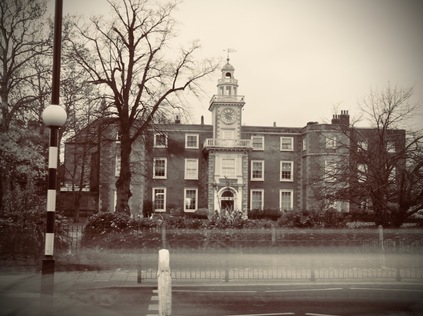
[...] teach and lead every child and older person to seize every opportunity to say a kind word or do a kind act that will make some other human being or some dumb creature happier.It felt rather odd to see Wood Green as a cradle of kindness and religious diligence as I approached a crossing the High Road. The flank of Haringey Civic Centre with its pleasing brick and stone lines betraying its origins in the late 1950s. From the rear, a dramatic wing of the building strode out across the car park on stilts with metal stairs elbowing into view, partially obscured by St. Michael's Church. A little further along the street, the Fishmongers Arms was a reminder of the Fishmongers and Poulterers Almshouses which occupied this site before it was a seat of Local Government. I crossed the street near the rather drab little scrap of park dedicated to King George VI which had been occupied by a dedicated drinking school on my last visit. Today it was empty, the cold weather and the stream of pedestrians heading for their festive retail destinations driving out the locals. I turned towards Wood Green with some trepidation...
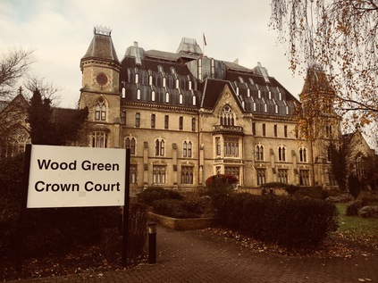
I wasn't sorry to make the turning into Lordship Lane near Wood Green Underground Station. The pavements were impassably busy, with people darting between streams of travellers emerging from the tunnels and some testy exchanges as they cannoned into each other in their haste. Pedestrians were laden with bags or staring into electronic devices, always too occupied to focus on their surroundings - and it struck me that I was the only person in this strange little urban swirl who was walking for the sake of the act. No wonder I was regarded oddly, my boots and trousers marked by dried-on Middlesex earth and my face masked by a scarf against the cold and fumes. A little south of here, somewhere under the massive brick ziggurat of Wood Green's mall, was the site of Alderman's Bridge where the River Moselle passed under Green Lanes and formed the edge of the building plots on the southern side of Lordship Lane. The road quickly reverted to suburbia, leaving the chaos of the shopping centre behind. However, the rather uniform buildings suddenly gave way to the somewhat bizarre Wood Green Crown Court building. Originally built as the Royal Masonic School for Boys, supporting the children of deceased and poor Freemasons, the building remained as a place of education until the 1930s when it was acquired by the Tottenham and District Gas Company and renamed Woodall House in honour of Sir Corbet Woodall, former chairman of the Imperial Gas Light and Coke company who is commemorated by a statue now at Twelvetrees Crescent in Bow. After nationalisation in 1948, the building found use as the headquarters of the Eastern Gas Board. In 1974 it was acquired by the Borough of Haringey and modernised to become Wood Green Crown Court and Remand Centre. The building's current appearance, with a dramatic and somewhat strangely mountainous roof filling the gap between the tower on each flank dates from rebuilding after an arson attack in 1989. The Court continues to find new ways of remaining in the public consciousness too - seeing Britain's first juror jailed for using the internet in contempt of court in 2013. Today, all was quiet outside the building except for a group of drinkers loudly discoursing in the garden - I couldn't help but wonder if they were the displaced group from King George VI Gardens, relocated to a more exclusive spot to avoid the crowds. Perhaps they are part of the civic fabric of Haringey?
I continued to head east, aware of the Moselle's hidden course nearby, recalled in the street names if nowhere else. I remembered my walk to find the remains of the river in a heady, turbulent summer five years ago. I hadn't quite imagined the turn my walks, or indeed my life would take after that. As the pale and stark towers of Broadwater Farm rose above the terraced houses lining Lordship Lane appeared, almost fading into the purple-grey sky, I spotted a housing development much more modest and human in scale as the Tower Gardens Estate edged against the road. This was the London County Council's well-intentioned but somewhat half-hearted attempt to bring a little of the Garden Suburb approach to deepest Tottenham. Built between 1904 and 1913, the semi-circular estate of cheaply but attractively built cottages is encircled by The Roundway, a diverted arm of the A10 which takes it away from its old course through Edmonton and onto a menacingly busy urban dual-carriageway. This means that Lordship Lane becomes a somewhat quiet backwater near Bruce Castle, the grand manor house built and modified over a long period of the 16th, 17th and 18th centuries. An early occupation by Sir William Compton, one of Henry VIII's most prominent courtiers is recorded, with the building variously changing hands through seizure, debt and sale across the centuries before falling into the ownership of John Eardley Wilmot who as a Member of Parliament was charged with leading a 1783 commission investigating the events of the American Revolution. He also presided over the rather lesser-known effort to provide housing and alms to 60,000 loyalist refugees who returned to Britain after Independence was declared. By 1827, Bruce Castle had become a branch of the Birmingham radical school operated by Sir Rowland Hill and his brother. Hill moved to Tottenham to become the headmaster of the new school, and his later career would take in planning the colonisation of South Australia and reform of the Postal System. Meanwhile, Bruce Castle found its final incarnation as a museum and garden in the ownership of Tottenham Council by 1906. It remains a similar facility today, under the stewardship of the post-1965 London Borough of Haringey, a rather odd intrusion of history into the heavily and relatively recently developed hinterlands of Tottenham and Edmonton. Incidentally, no castle has in fact, ever stood on the land here - though large tracts of the area were owned until his accession to the Scottish throne in 1306 by Robert the Bruce. The manor here is recalled the rural setting which Bruce would have known in John Abraham Heraud's 1820 epic poem 'Tottenham':
Silent and lone, and on the greensward dies -
But when on ye her heavenly slumber lies,
TOWERS OF BRUS! 'tis more than lovely then. -
For such sublime associations rise,
That to young fancy's visionary ken,
'Tis like a maniac's dream - fitful and still again.
Outside Bruce Castle I faced a choice. Technically, the A109 continued for a few hundred yards towards Edmonton where it came to an end on the old High Road. However, I'd walked that last stretch before and had found it a rather gloomy stretch of route somehow. Beside me, Bruce Grove cut the corner, heading directly south-east towards the station with which it shared a name, and taking this turn could save me from ending my last walk of the year at a drab, inconsequential crossroads. I paused for some time, deciding whether to break my self-imposed rules here. It's true that this was perhaps the last of these 'orbital' walks in the North, and it felt odd to be changing the plan at this late stage. But I'd walked for miles, the light was beginning to fail, and the chill damp of the afternoon was finding its way to my bones as I tired. I reasoned that it had been a long, challenging year of walks - and it should at least end by covering new ground - and so I broke my rule and struck out along the previously unwalked line of Bruce Grove. The station beckoned, the railway bridging the junction ahead, declaring the location in bold white letters on the blue ironwork. The sky had turned a pinkish-grey as the weak winter sun fell and the streetlights were developing halos in the frosty air. It was the perfect way to head back towards civilisation. I had almost walked the length of the A5109 and the A109, an arc across the northern reaches of the old County of Middlesex - a deleted administrative unit which had come to figure largely in my travels this year. Descending into the Lea Valley from the Northern Heights felt like a perfect way to enter the seasonal pause in my walks. My decision not to cover those last few yards niggled at me - but as I boarded the train for Liverpool Street, I found myself sitting across from a young, smiling woman who was devouring an artisanal doughnut with enviable guilt-free glee and happiness. It was impossible not to get caught up in the sense of contentment: my feet ached from a walk completed, I had a host of surprising finds to unravel and research, and as ever new twists and turns had suggested future exploration on the way. Perhaps rules were meant for breaking after all?
You can find a gallery with more pictures from the walk here.
Lost::MikeGTN
I've had a home on the web for more years than I care to remember, and a few kind souls persuade me it's worth persisting with keeping it updated. This current incarnation of the site is centred around the blog posts which began back in 1999 as 'the daylog' and continued through my travels and tribulations during the following years.
I don't get out and about nearly as much these days, but I do try to record significant events and trips for posterity. You may also have arrived here by following the trail to my former music blog Songs Heard On Fast Trains. That content is preserved here too.
