I hesitate to tag this as a 'London' post. It is marginal, in the shaded zones at the edge of the map. As this walk takes me further from the city, I start to look for an edge - the M25 is too obvious, and the city's gravity extends far beyond it into the vampiric region which sucks the economic life out of Southern England. Maybe the countryside that divides Essex from the London Boroughs? That almost non-existent band of greenery is all too easily missed - an overgrown car park of a decommissioned roadside pub readily mistaken for a nature reserve. The truth is, I don't have an easy edge against which to snap my definition - and if Southend Airport is now 'London' too, perhaps I should give up trying? Perhaps this whole esturial swathe is now London too? The glottally punctuated accents, the harsh tang of heavy metals in the air, the constant drone of tyre on tarmac - they are all London's trademarks - and they're with me as I walk. I was equally hesitant about picking up this project again after a pleasant festive season. It felt like last year's work - a snuffling away at the margins in an attempt to walk off the seething frustration of a year spent in limbo. It felt derivative - it had all been done by hardier souls with a better turn of phrase. Was there anything left to discover our here? All the shallow gangland burials unearthed decades ago, all the surprising vistas captured by photographers with lenses long enough to avoid actually visiting the edge lands. If today went to plan, I'd walk off some edges and into known unknowns - stations a mere half-hour from Fenchurch Street which felt desperately remote on foot. I needed to recalibrate my scale to understand how this journey, too short to read a book or hear an album on the rails, was a minor epic now I was walking.
Heading out to my starting point, I realised that I might have to rethink today's objective. Getting to Beckton isn't quick, and with the train lazily timed due to engineering I had a fairly late start. I rumbled around the Circle to Tower Hill, made a quick dash to Tower Gateway and settled into a DLR train which slowly but surely took me out of the city, past the recent history of my walks once again. It was years since I'd arrived at Beckton this way on an exploratory trip to cover the DLR. I remember feeling like it was some impossibly remote outpost - definitely not London back then. Since I've shaded in the territory between the city and the Alp this view has changed of course, but it still feels like an ending. The ski-jump of the unfinished ramp over Gallions Reach ascends to cross the tracks, its post-modern adornments which should have given entrance to a new river crossing blasted by wind and particulate matter. I start walking immediately and with perhaps a little too much enthusiasm. I need to get moving, pushing into the strengthening wind but mercifully dry so far. I turn north, the green slopes of the Alp ahead - and I feel almost guilty for not climbing it today. After all the strange symbolism I've invested in this artificial mound, it seems odd not to pay tribute. I pass by, climbing the on-ramp to the A13: boiling with traffic, the rare gaps between cars filled with spiral eddies of wind-borne dust. This isn't quite new territory yet - I'm passing the vast Sainsburys store I visited on my first trip out here, the road curves steadily around it, hugging the white sheds of the retail park. After skirting the connection with the North Circular nestled beside a Waste Transfer Station and steeped in the aroma of decaying vegetable matter, the road bucks and rises in front of me. A swathe of reeds and a slender curve of brown water below indicate approximately where the River Roding becomes Barking Creek and escapes the tightly walled channel it has followed from Ilford. Looking north, across six lanes of shrill white vans, I see the ponds and inlets of Cuckolds' Haven - another walk where I'd turned aside, unsure of my right to roam and cursing my reticence. From the shallow bridge, the flood relief barrier is barely visible as a huge turbine blocks the immediate view. Only the blast of cold, esturine air gives rumour of the Thames. Creekmouth spreads across the southern view - low-tech industry and scrap, the town of Barking tucked safely away to the north. The road stretches ahead somewhat uninvitingly in a concrete-walled trench. I wonder if this is a sensible plan after all?
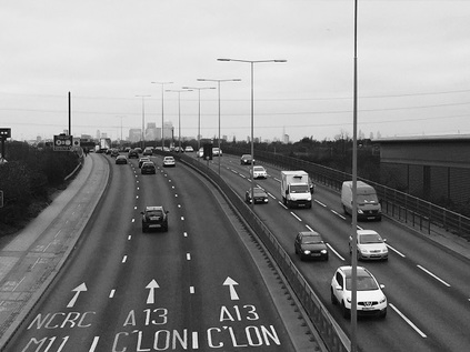
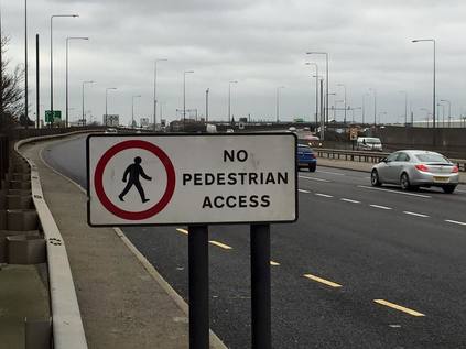
The A13 is a dividing line here - north of the road is civilisation, with solid and reliable 1930s housing schemes butting up against the road, built for the future car owner with easy access to everywhere. South of the carriageway is the sliver of industry which skirts the marshy banks of the river. Abandoned power stations, rusting networks of de-purposed pipework, bored security guards who seem to have been forgotten by everyone except the payroll. They just keep turning up, crumbs on the regulation navy sweater, cap at an angle. Are they stopping me getting in - or out? I cross a footbridge to the northern path - mostly because I see a filling station with a sideline in coffee. I'm the only non-driver in the place. The assistant spits "No fuel?" disbelievingly before reluctantly scanning my Nectar card. I shelter next to a battered tump of greenery outside the garage to stash my purchases and shoulder my bag realising that there's really no provision for leaving the place on foot. Refuelled with the curious mix of caffeine and warm milk I increase my pace. I'm feeling a little post-viral, below par and wonder if I can really achieve quite what I've aimed for. Right now, it's good to be walking but I know I'll tire faster than usual. Walking into the wind doesn't help - my face feels raw and bitten, my knuckles turning from red to white and back. The road is relentless. The surface noise has a hypnotic regularity. I check my maps and note I'm edging onto the last page of the A-Z. There are no more of the comforting blue continuation markers on the right edge of the book. When I bought it, almost exactly twenty years ago I couldn't imagine who needed these maps of distant suburbia, so impossibly far from the core of things. Now I was about to leave the map and I felt a pang of anxiety. This wasn't going to be London at all.
The road continues, still describing a shallow arc across the flat floodplain between the River Roding and Dagenham. The route is lined by a sound-repelling perspex fence as it begins to rise above the low blocks of housing on the northern edge. A green space opens out, stretching along the line of the railway which passes beneath the road but above the arrow-straight silvery line of Mayes Brook, heading south towards Barking Creek, encased in a narrow ribbon of green which extends along its route from the old A13 to this new interloper. North of here, the banks are reclaimed and offer a perimeter to the leisure zones of Mayesbrook Park, but this stretch is neglected by all but the most intrepid of dog walkers. This three-level crossing of routes marks something of a boundary. As I descend from the bridge, the first hint that walkers will be barred from the route at some future point are mooted by the signage. This is a temporary prohibition in fact, to account for the narrow and crumbling blue steel viaduct which carries a meagre few lanes of the A13 above the junction with Ripple Lane - its own earlier incarnation. The need to evade this junction is clear - aside from the flyover this is essentially a suburban roundabout - the northern flank surrounded by tired council dwellings and the southern given a view over the great Ford Motor Company water towers and wind turbines. Wedged into the triangle of land at the western edge of the junction is the Thatched House - a barricaded pub of currently uncertain status. Its vintage 'Double Diamond' sign still pitched on its high 1930s chimneys, the car-park off-limits and serving as overspill from the nearby junkyards. The whole place a grim and solemn roadside reminder of a convoluted, sorry past. The pub appears to remain a notable venue for African music and cuisine, but right now it is a dormant and oversized red brick behemoth of the type which adorned every well-planned municipal estate at first. A little further ahead, across the dual-carriageway, the Ship & Shovel presents another face of Dagenham nightlife - a displaced cottage style public house, oddly truncated and cluttered with unrelated vehicles. It looks as forlorn and menacing at the Thatched House, if a little less decommissioned. Edging around the traffic island and back onto the main route, I'm soon forced off onto an ancillary track. This appears to be the perimeter road of a new, tidy development of small family homes. At the end of the access road, I'm returned to the shuddering heave of the A13 as it passes Castle Green - a gloriously ungoverned tumble of green space fronting generous sports fields. As I draw nearer A series of curiously jumbled silhouettes on the flat grey sky resolve into local celebrities - inspiration for the pupils of the Jo Richardson Community School. Here on the edges of the city, the heroes are ultra-local in response to the reputation for non-integration. Casual racism was formalised into BNP council seats, and is now offset by naming public facilities after notably radical Socialist MPs. It's hard to know if it works - there's a metallic tang to the air here which reflects the sharpness of the knife-edge Dagenham sits on. There's a lingering sense it could collapse into either violence or utter indifference at any point as I navigate the slalom course of wind-toppled recycling bins which line the footway.
The path leaves the road here and skirts the pithily titled Dagenham Leisure Park. It appears in fact to be something of a relic - a former strip-mall of DIY retailers in the Midwestern vernacular, transplanted to the fringes of the old A13. With Lakeside now a short diesel-burn away, and with the main road curving away to the south on elegant stilts, only a cinema and a range of fast-food restaurants remain among the generous carparks. Footsore, lacking energy and desperate to use the facilities, I enter McDonalds. The monotone of the windy road is broken immediately by the screams of children, the cackling laughter of teenagers and the esturial admonishing of parents. It sounds hellish after the weirdly alluring swish of tyre on tarmac, but a cheap refuel beckons. I tough out the torture, pop painkillers and return to the road, my coat buttoned against the bitter wind. My road from here on is the A1306 - the redundant ghost of the old A13, fringing the residential edges of Dagenham as they break on the industrial foreshore. First though, there is a last knot of civilisation - a barricaded Indian Buffet restaurant which claims to be the 'largest', next to a much newer and far more capacious establishment which may well have caused this sorry end. There are mis-spelled signs and curious mash-ups of taxi office and take-away - but photography seems wrong here. I gorged on ruin-porn in those first few shuttered yards of Fieldgate Street. Here, away from the planning blight and regeneration schemes, it feels less edgy and more forlorn. Everyone should have to walk the mile from Dagenham to Rainham, across the Beam River and off the A-Z, before they critique local planners. It signifies the impossibility of making a community work by buildings alone. A little way from here sits Becontree, for many years the largest municipal housing scheme in Europe, radiating spurs and crescents of good, solid homes like an incomplete crosshair on the map. But here at the edges, it doesn't feel planned or controlled. It feels abandoned. Just before I cross the old A13 to head south I notice a new development with a street name which captures the mood: Passive Close.
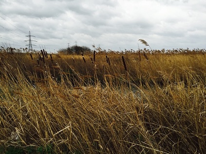
Bridge Road turns away from the road, towards a Tesco of epic proportions, crossing the reedy twist of the Ingrebourne River. I could head directly for the station here to end what has been a challenging first trek of the year, but the river interests me, and I want to see the marshes before I make a definite decision not to press on today. Three more miles? Surely I could manage that. Lamson Road is an industrial short-cut, taking traffic away from the town and along a dusty gully which parallels the river as it becomes Rainham Creek. The lack of development ahead means the dry, cold wind howls at me as I turn east. I'm chewing grit and sucking dust I don't dare to think about. At the next turn south onto Ferry Lane, an official footpath is signposted. I climb onto the ridge and the marshes open before me: a swaying plain of grass and pylons trapped between railway and road. To the south the elevated A13 severs the view, the heaps of landfill rising beyond. I set out a little way south along the path, still thinking that maybe I could cross the marshes today. A stylishly rusted iron signpost, digits and destinations marked by stamped-out sky-coloured absences, tells me it's almost four miles to Purfleet. I decide this is the spot to call this walk finished. I stand for a while, looking at the marshes and watching the High Speed trains flash by. I've been carrying a key to my parents' flat for years, but since the turn of the year I've been uncomfortably aware of it - a cold metallic pocket weight, linking me back to a year of anxiety and a place which is now just a memory. I'd always thought I'd go somewhere meaningful and memorable to ceremonially dispose of it - but I'm suddenly taken with the idea that this place is perfect. This seemingly endless swathe of bleak, open marsh where almost anything can - indeed has - been hidden. Somewhere things can disappear. A place without - and perhaps beyond - memory. I unlink the key from its ring and pause. Feeling the cold metal in my wind-dried hand, I wonder if this is such a good idea. To ditch the symbol in a spot which I'm sure I could never relocate exactly, and will probably never knowingly revisit? Of course it's perfect! I marshal my thoughts and before I can reason further, hurl the key as hard as I can into the sluggish reedbeds of the Common Watercourse. So hard in fact it almost reaches the clumps of tall grass on the other bank. But it's gone - beyond retrieval, the ripple signature settling into the still green mirror. The wind swirls and I see a party of walkers heading in from the marshes. I snatch a quick picture for posterity: grey clouds marching swiftly over an austere powerline panorama. A train from the continent roars by. It's time to turn for home, the unlikely ceremony complete and a long, difficult chapter closed.
You can find a gallery of images from the walk here.
Lost::MikeGTN
I've had a home on the web for more years than I care to remember, and a few kind souls persuade me it's worth persisting with keeping it updated. This current incarnation of the site is centred around the blog posts which began back in 1999 as 'the daylog' and continued through my travels and tribulations during the following years.
I don't get out and about nearly as much these days, but I do try to record significant events and trips for posterity. You may also have arrived here by following the trail to my former music blog Songs Heard On Fast Trains. That content is preserved here too.
