
Via Antiqua: By Watling Street from Kent to London
Posted in London on Saturday 28th April 2018 at 11:04pm
Today's walk had crept upon me unexpectedly. The weeks had tumbled by unusually swiftly and a confused calendar thanks to rail works and changing plans meant I'd not prepared myself. In reality, the process of planning a walk isn't as onerous or complex as I often make it sound: usually, it's a germ of an idea followed by a cursory study of a map to ensure there is actually a path to follow. The research comes afterwards, reconstruction undertaken with feet smarting and imagination fired. There are numerous half-formed plans circling at any given time - and sometimes one leaps forward as an essential next step or perhaps just won't quite stop cropping up, coincidentally or otherwise. It was just one of these nagging presences which drew me south of the river again today... I felt like I'd been haunted by Watling Street for years now. I had a map of Roman Roads as a boy on which I'd been shown how close my home was to the confluence of Icknield Street and Fosse Way - but it was the improbably perfect diagonal trajectory of Watling Street which most intrigued me. After lying dormant in my imagination for years the road had resurfaced - first in print with Jon Higgs state-of-the-nation travelogue and Iain Sinclair and Alan Moore tramping Steve Moore's 'psychic circuit', then it began to assert a presence on the ground seemingly wherever I've walked in recent months. When I've looked at maps to plan future excursions the arrow-straight incision across the north of Kent has been impossible to ignore. The red slash of an A-road scythed across the map like a fresh, clean paper cut. Walking roads - ancient and often less so - has some precedent here, so it didn't feel strange to plot a course along the route as a potential future trip. Yet I still filed this one away, for an especially rainy day perhaps - because surely a straight line couldn't make for the kind of convoluted itinerary I'd prefer? But as I prepared hastily for this trip, I couldn't quite shift the idea that I needed to connect up previous walks via this old track.
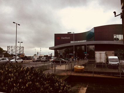
And so I made my way to Charing Cross to take my pick of the carriages on an empty train to Dartford. The rumble and shudder through the southern suburbs was becoming very familiar now but felt somewhat eerie as I appeared to be almost entirely alone onboard. The train snaked through the refurbished London Bridge station - grey plastic panelling and swooping escalators descending into the re-imagined undercroft - and left the gravity of the city. I let the greenery of the suburbs drift by the window while I pondered my changing relationship with Kent over the years. On my first excursion here I was entirely unimpressed: the ponderous amble through the middle of the county by train was dull and charmless, ultimately leading to desolate, unremarkable Ashford. I revised my view over subsequent visits - especially those involving the northern coast which had grown to fascinate me. Now, after a sequence of walks which had dallied along the border of the county, I was curious to exit by this most ancient of trackways. It felt like a fitting way to mark a re-evaluation. The train slowed after passing familiar ground at Crayford, and high above the marshes I could see the towers of the Dartford Crossing and the distant glower of Essex on the horizon. Lurching across the junctions where the splayed branches of the North Kent Lines finally reconstituted themselves into a single railway, the train slowly came to a halt at Dartford. Below the raised platforms of the station, I spotted the former millpond fed by the River Darrent which was busily being redeveloped as a waterfront living opportunity. The narrow platforms and dated, gloomy exit stairs led out to a modern but down-at-heel ticket hall tacked onto the rear of the Borough's grim civic centre. A bridge took me over the busy inner ring road, descending near the red brick flank of the Orchard Theatre. Dartford was a town which had willingly conceded its soul - and just a few miles along Watling Street the vast hole-in-the-chalk of Bluewater sucked the income out of the locals with alarming efficiency. Dartford mopped up the rest via a network of pound shops, chain pubs and gambling opportunities. I headed for the centre of town where Spital Street followed the ancient geometry of the Roman road, heading in from the settlement of Vagniacae at nearby Springhead. The site there had been a centre of worship before the coming of the Romans, with evidence of Iron Age rites near the pools where the River Ebbsfleet rises. The tradition of worship and offering continued, with the Romans turning the site into a major complex of temples - and now Bluewater stands close by, drawing its own pilgrims. Perhaps grim, inward-looking Dartford has always been the poor relation hereabouts? I turned west on Spital Street, suspecting that any hint of interesting shopping opportunity lay along the pedestrian zone to the east. The narrow road was lined with abandoned shops, proper old-fashioned independent cafés emitting tempting breakfast aromas and a brace of repurposed theatres deputising as evangelical churches. I felt uncomfortable, though there was nothing especially menacing about the place. Perhaps in fact a little edge would have helped. Dartford just felt tense and contracted: out of the gravity of London despite being (just) within the grand circle of the M25. I began to climb West Hill, finally falling into step with the historical route of Watling Street as it passed the Royal Mail sorting office and the crumbling remains of The Lock-up: Dartford's first police station and latter-day dosshouse for itinerants. It was good to be walking, and a relief to be leaving this oppressive town.
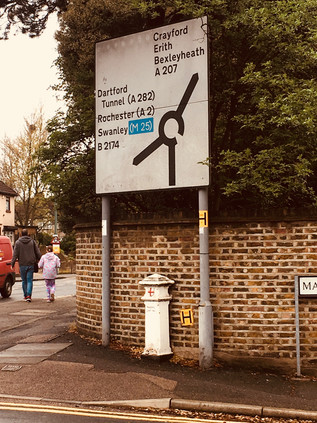
The last stretch of Watling Street within the boundaries of modern Kent was a drab channel through suburbia, with occasional bursts of local shops which were invariably closed for business. The land rose gently ahead of me as I crested the narrow tongue of high ground which separated the Cray and the Darrent. It struck me that only a few weeks ago I'd been further north on the bleak marshland which sat between this road and the Thames. Up ahead was a junction with the B2174 - an inauspicious number for what was an early incarnation of that most British of institutions, the bypass. The road arcing south around Dartford and avoiding the narrow progress of Watling Street through the town was opened by the Prince of Wales in 1924 - or perhaps by an overzealous worker who severed the ribbon in advance of the royal scissors. The press of the time dubbed this the 'New Watling Street'. The road meets its much older counterpart at this rather inconsequential roundabout which, since 1965 at least, has formed the border between London and Kent. Looking west there a proud sign advised motorists that they were about to enter the London Borough of Bexley, while to the east Kent offered no such welcome. There was however a marker here - squarely between the poles of the sign advertising the roundabout an 1861 Coal Duty post remained in place and in good shape. As my excursions have taken me further out into the suburbs of London, these administrative obelisks have become welcome markers of my progress back towards the City. Finding one here today felt like a first indication that this might be a more interesting walk than perhaps I'd expected. There were few other signs that I'd passed into London - the line of former council houses didn't break step, even when the insignia on the wheelie bins changed. Beyond the junction, the road led downhill once again, into the valley of the Cray. There was a brief thrill of familiarity as I noted the retail parks which had greeted me when I'd entered Crayford from the south. I braved a pair of scornful, braying locals concealing cans of Special Brew to snap a picture of the clock tower before heading across the river. Crayford was much as I'd left it a few short weeks ago - a busy churn of suburban life shot through with traffic heading for Bluewater or Lakeside. It was only after a few minutes of brisk uphill walking that I realised my plan to attempt this walk largely without a map had failed me. The road had turned slightly north to cross the river and I'd blithely headed straight on. The High Street began to dwindle as I climbed, the local shops being replaced by a string of takeaways and abandoned vape shops. I knew this wasn't where I should be and instinctively stopped to consult the map. I had indeed gone straight ahead - but the kink in the route over the river had thrown me off course by about 45 degrees. I trudged back downhill, acutely aware I was passing people I'd just moments ago huffed past on my ascent. I adopted a facial expression which I hope conveyed that of course I'd meant to walk up the hill and back again so soon. Back at the bridge I turned southwest, immediately recognising the route I'd taken in reverse along London Road while walking along the Cray. I was back on track.
Watling Street was dominated for a few miles now by suburban encroachment. The green spaces of Shenstone Park and Bigs Hill Wood gave some relief from the parade of recycling boxes and wheelie bins as the road made a steady climb away from the Cray valley. I'd been intrigued by the near life-size silhouette bronze sculptures of cows in Shenstone Park on my last passing, and getting closer enabled me to read more of the story: David Evans & Co. made silks nearby, using the Rubia Tinctorum or Common Madder plant to create a vivid red dye and maintaining a herd of cattle on the site to provide manure to fix the colour in the cloth. Beyond the park, the road returned to suburbia, still climbing as I faced down a cold, persistent drizzle of rain. The rise reached a plateau at Pinnacle Hill - a rather overstated name perhaps - and the view ahead opened before me. This was Bexleyheath, as announced by the strange tumble of gables and brick of the new Civic Centre. For many years the busy corner of Watling Street and Erith Road was occupied by the computer centre of The Woolwich Equitable Benefit Building and Investment Association which those of a certain age will recall being advertised in a chummy inclusive fashion: "I'm with The Woolwich". In the heady days of 1989 they made a bold move to relocate their HQ into a purpose-built block on this corner. The heady days of demutualization and acquisiton that followed were a small part of the build up to the crashes of 2007, and by 2006 the Woolwich was part of Barclays PLC and the HQ was closed. The Borough stepped in, selling the site of their civic offices to Tesco and snapping up the Woolwich site as a bargain. The redeveloped area was disarmingly quiet at the weekend - built in part as a plaza to cap the busy High Street, there's little need for people to press on this far beyond the shopping centre. The Civic Centre towers and tumbles above the crossroads, facing London defiantly, the exterior only hinting at the impressively refurbished, modern facilities within. I waited at the crossing for what seemed like long minutes, sharing my wait with a couple off to a wedding who were impatient to get out of the rain - there was a concern that suede would matt and hair would frizz. I considered my own appearance, bedraggled and damp, red-faced from stomping the hill from Crayford, and figured that the well-turned-out pair had little to worry about yet.
After crossing Erith Road, Watling Street becomes Broadway, the main drag of Bexleyheath - and a relative newcomer to the area. In the early 19th century the wild heathland pressed directly against Watling Street and there were few houses in the area save for the hamlet of Upton where William Morris decided to locate his 'palace of art' - The Red House in 1859. The construction of the house, which was swiftly absorbed into the suburbs as the commercial centre of Bexley shifted onto the heath and Upton was swallowed, largely bankrupted Morris. He was forced to sell up in 1865 vowing never to return to the house or to Upton. Now, two broad bypasses sweep traffic north and south of the centre, leaving Broadway to continue as a pedestrianised walkway on the line of Watling Street. This largely featureless, pavement, part-covered by an inaqequate awning, delved between a carpark and an extension to the 1984 shopping centre including a huge Sainsbury's and a multi-screen cinema. As ever I was walking against a tide of shoppers heading for their cars or buses home. Across the expanse of parked vehicles, the white chequerboard flank of the utilitarian Magistrates Court gleamed, all the better for a soaking of rain to slough away the traffic grime which still streaked the less exposed rear of the building. This wasn't, I'm sure, how Bexleyheath wanted to be introduced to newcomers - and it seems that the ceremonial march along Watling Street didn't do the place justice at all. As the enclosed alleyway which I'd been walking burst out into surprising sunshine, the street opened out into a much redeveloped and bustling market square. At the centre was the Clock Tower erected in 1912 to commemorate the coronation of King George V. The architect, Walter Epps, designed the tower with niches which he hoped would in time be filled by busts of the Royal Family which has largely been the case - though in 1996 a bust of William Morris was allowed into the hallowed company to celebrate the centenary of his passing. The tower was a focal point in a pleasing pedestrianised area which stretched along Broadway, taking full advantage of the straight-line of the Roman Road to create a promenade between the modern shopping centre and the more traditional street scene to the north. In 2000, to celebrate the millennium, the bells in the Clock Tower rang for the first time since they were silenced by the Defence of the Realm Act in 1914. I was surprised how much I liked Bexleyheath - in essence just another fringe centre which ought to feel as oppressive as the hugely redeveloped Wood Green. But here, just enough of the town had survived, and just enough of the character of a place which was not ancient but remained proud seemed to linger. I decided to stop for refreshments and watch Bexleyheath pass by for a while.
A consequence of the long, straight course of Watling Street is the tendency of settlements to become drawn-out, straggling places - and Bexleyheath appeared reluctant to give up just yet. The twin bypasses rejoined Broadway to the west of town, and traffic was once more permitted to flow along the ancient road - though it was relatively sparse given the swifter route of the A2 carving through Kent a little way to the south. I crossed the junction of Upton Road, practically all that remains of the now subsumed hamlet, and where I'd turn south if I wanted to visit Morris' home - today though I pushed onward as Watling Street became the curiously named Crook Log. Opposite the apparently well-used leisure centre of the same name, the Morris Wheeler Gates of Danson Park proudly bore the insignia of Kent and its motto Invicta. This impressive green space was gifted to the Borough in 1925 having previously been part of the lands surrounding Danson House which remains at the heart of the park, with views over the ornamental boating lake. The house was built in the 1760s for Sir John Boyd, a prominent figure in the British East India Company, and there is debate about whether it was Capability Brown himself or his assistant and scholar a 'Mr. Richmond' who laid out the lake and parkland surrounding it. Little appears to be known of this mysteriously acolyte save for the plans for Danson Park which survive in Bexley's archives. By the time of Boyd's death, the area was already in use as pleasure gardens, and the association with recreation continued despite being threatened by its acquisition by Alfred Bean, a railway engineer and prime mover behind the Bexleyheath Railway Company who envisioned the area becoming a vast residential estate. On Bean's death in 1890 some areas were indeed auctioned for building plots, but by 1921 on his widow's demise, the Urban District Council acquired the land at auction. In 1937, Lord Cornwallis presented the council with the status of a municipal borough under an ancient oak tree in the park - and the Charter Oak remains enclosed within the park, and indeed in the arms of the Borough of Bexley. The park and house have benefited from much restoration in recent times, and it seemed busy with locals despite the rather gloomy beginning to the morning.
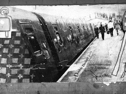
Danson Park marks a passing which would otherwise be hard to detect - from Bexleyheath into Welling, another long and drawn-out settlement which hugs the line of Watling Street. Welling, while perhaps not as significant in the borough's recent past, has a longer history. Evidence of neolithic occupation has been unearthed at East Wichkam, now wholly absorbed into modern Welling, but once a distinct village which once housed a temporary village of workers huts serving the Royal Arsenal at Woolwich. This link is celebrated with the loan of a 36lb Russian cannon which sits at Welling Corner, now largely ignored by passing shoppers but favoured by clambering children. The railway reached Welling in 1895, crossing the western end of the long High Street via a high brick bridge, and opening up lands north of the area for development by way of a station a short walk from the main street. The long stretch of shops leading to the bridge still maintained a prosperous and pleasant air, with a surprising diversity of stores - the usual suburban mix of chicken shops and cafés supplemented by craft stores and the like. Welling also benefitted from several major supermarkets setting-up shop in premises along the line of the main street rather than at some spot on the outskirts, thus ensuring a constant stream of pedestrians along the pavements. I was acutely aware that London was just over the next hill - at least the London which most would recognise as such - but this place felt full of provincial bustle. Perhaps Welling really was the last outpost of Kent - and the insignia on the gates of Danson Park referred to its triumph over the creeping suburbanisation of the borough? It might seem that London was close by, its inevitable gravity already pulling in road and rail, but ahead of me was a mighty barrier, and rising above the line of the railway bridge a distant green smudge against the grey skies signified Shooters' Hill. Rearing above the road, this formidable barrier had been easy to ignore until now. I tightened the straps of my rucksack and marched onwards, under the railway bridge with its rather impressive murals of Bexley life, including an image of the ill-fated and short-lived double deck trains of the Southern Railway. It was time to head back into the city...
Despite the grey skies and general gloom, the day was becoming warm and humid, and as I passed the last possible place I could rest before my ascent at the appropriately named 'We Anchor in Hope' public house, I decided that my best chance for an assault on the hill was to tackle it in one lung-busting push. Detours into the temptingly dark and cool Oxleas Wood to the south could await another walk, and the opportunity to stray into Woodlands Farm to see gambolling baby lambs needed to wait too. Instead I looked ahead at the straight, steep road disappearing into the tunnel of overhanging trees. At the foot of the hill a burned out car had collapsed onto the driveway of Thompson's Plant and Garden Centre, notices explaining that there was currently no parking or vehicle access. The air nearby had a taint of melted electronics and charred fabric. I edged uneasily around the stricken vehicle and began my climb. At first it felt surprisingly easy - the hill, though 433ft high was not steep on its eastern flank, and the walking was challenging but manageable. After a steeper and sharper rise near the summit which was more taxing, the road levelled a little near Eaglesfield Road. I turned north, puffing into the quiet park which sat on the brow of the hill here, and found a seat to survey the view back east. The description of the prospect from the top of Shooter's Hill written by Celia Fiennes has perhaps never been bettered - and remains remarkably accurate today. Fiennes was born in 1662 and never married, instead embarking on a series of tours of England which she undertook "to regain my health by variety and change of aire and exercise". Her memoir, largely intended for friends and family, was never published in her lifetime but has since seen the light of day, providing a remarkable contemporary account of the country as it thundered haplessly towards industrial revolution.
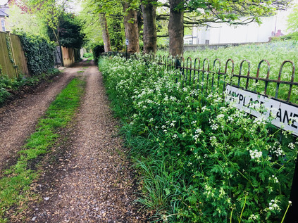
Shuttershill, on top of which hill you see a vast prospect ...some lands clothed with trees, others with grass and flowers, gardens, orchards, with all sorts of herbage and tillage, with severall little towns all by the river, Erith, Leigh, Woolwich etc., quite up to London, Greenwich, Deptford, Black Wall, the Thames twisting and turning it self up and down bearing severall vessells and men of warre on itIn the distant haze I could see the Dartford Crossing, close to where I'd set out earlier this morning. The suburban settlements along the railway and on Watling Street formed a continuous chain of red-brick smudges stretching from the horizon and ending near my feet. There was a surprising presence of green spaces too - not always evident from the ground, but nestled between developments and in the useless triangles abandoned where estates adjoined each other there were clumps of trees, patches of suburban parkland and expanses of municipal playing field. Kent shimmered in the distance, the Thames visible mostly as an absence from this vantage point. I pondered the walk to this point, and planned my next move. Since I was here on the slopes of this hill with its neolithic history it felt only right to seek out the Shrewsbury Tumulus where Steve Moore had anchored his esoteric visions of this neighbourhood. I would be treading in the recent steps of better writers and deeper thinkers once again, but it felt wrong not to make the short walk over the ridge to the mound. A meander through the quiet streets brought me to the mound, tall grasses and a bright swathe of wild flowers almost concealing its form. The corner site, fenced in and protected, was a quiet place in an already sleepy residential suburb. A curious peace lay across the Shrewsbury Park Estate with its fine 1930s homes glowing in the afternoon sunshine which had finally made an appearance. The parkland here was associated with Shrewsbury House which stood nearby and was rebuilt as recently in 1923, and was later purchased by the London County Council for new housing. The archaeological significance of the area was already reasonably well-known - but only one of the Iron Age tumuli survived even then. Watling Street likely long pre-dated the Roman road, an ancient track to a place of burial and reverence atop the highest point for miles around. I paused a while, intrigued by the apparently ancient route of Mayplace Lane which wound downhill towards the Thames. This narrow track had been paralleled by more modern routes, but still found its own meandering course down towards the shore. I noted its route for further investigation - intrigued by the suggestion of a route to causeways over the marshes. I'd been a little sceptical about the lure of this place which appeared to completely ensnare Steve Moore, working its way into his writing - even indirectly influencing the work of (the unrelated) Alan Moore with whom he frequently collaborated. In the work of both Moores there was a deep historical significance to place, and Steve had anchored his visions deeply here on Shooter's Hill. Considered alongside distant Shepperton in the west, the houses provided a fitting counterbalance of mid-century modernity. In these geographically distinct suburbs Moore and Ballard worked to redefine their environs in dark fantasies. Somehow their visions grounded London, pinning down its sometimes hazy character under a near-perpetual dome of cloud and drizzle, and providing a dream life for its suburbs.Diary of Celia Fiennes - 1697
I returned to Shooter's Hill near The Bull, a long established refreshment stop those who had tackled the ascent of the hill by coach and presumably wished to celebrate doing so unmolested. Now it promised suburban taproom character at London prices. The famous water tower leered above the hostelry, now a private home with unparalleled views across Eltham Common towards Severdroog Castle, or over the Thames to the aspirational environs of Galleon's Reach.
The western side of Shooter's Hill had seen work to flatten the climb during the 1950s when lower powered motor vehicles didn't always make the crest, and now the road dipped into a man-made chasm between the pavements. Walkers were consigned to the original gradient, steep enough to give me the uneasy sense of tumbling forwards and to conjure a dull ache in my shins. Much of the southern side of the road was occupied with the Memorial Hospital, now largely providing mental day health services, the grand gateway advised those with more pressing issues or injuries to head for the Queen Elizabeth Hospital in Lewisham. Opposite the hospital and set back from the road, the Red Lion was preferred over The Bull for staging Mail Coaches on the route to Dover and remained an inn of a fairly unreconstructed nature - offering a special on pies and pints, and a full range of Sky Sports channels. Beside the pub, a terrace of five cottages stepped down the hill and it struck me how isolated a spot this must once have been. Shooter's Hill was, for centuries, synonymous with utter lawlessness. The slow climb and the wooded areas around the hill made the work of highwaymen all too easy - more visceral and far less romantic than stories suggest. During the reign of Henry IV the crown ordered clearance of trees along the edge of the road to prevent 'violent practices' yet these persisted - and indeed increased in frequency - for centuries to come. Even the practice of hanging the corpses of executed thieves over the road as a warning seems not to have deterred attacks, with Samuel Pepys describing in his diary for 1661 passing by "the man that hangs upon Shooters Hill". By the 19th century a substantial village had begun to grow on the slopes north of the road, while Eltham Common had been partly cleared to the south. The presence of a range of larger houses and follies such as Severdroog Castle had also altered the character of the area considerably. It was no longer necessary for Eltham to maintain two Police stations to manage the disorder in the area, as was the legend. My own nod to this history of malfeasance was to disobey signs ordering pedestrians to cross the busy street to avoid some apparently abandoned roadworks, and feeling justly proud for maintaining tradition, I came upon the crossing of the South Circular. I recalled standing at this spot while stormclouds massed over the city, pondering the walk ahead of me. Today I continued westwards into Blackheath, passing the former Royal Herbert Hospital which had, for over a century, housed veterans of British military expeditions overseas. Built initially to house those returning from the Crimean War, the facility opened in 1865 and many of the then-innovative design features arise from the input of Florence Nightingale who had been sent to the Crimea by Sidney Herbert, Minister of War and had formed very clear views on how casualties should be managed both on the field and back at home. Royal Patronage came in 1900 when Queen Victoria visited veterans of the Boer War at the hospital, then noted for its fine buildings and health-giving proximity to the open spaces of Oxleas Wood. The hospital remained in use as an Army teaching hospital, admitting civillians injured in the wartime bombing of the Royal Arsenal and caring for injured prisoners of war during the World Wars. The site finally closed in 1977 and the fine buildings appeared doomed until the designation of the Woolwich Common Conservation Area and a Grade II listing. Now, predictably, the buildings have been converted to luxury accommodation with pools, bars and tennis courts on site. A little further west, near Hornfair Park was another location dedicated to the relief of wartime suffering - this time for the animals innocently caught up in human conflict. The Old Blue Cross Cemetery was founded by the curiously anachronistically named Our Dumb Friends League in 1897. The site once also housed a bustling kennel and quarantine point for animals returning from war overseas, but this was closed by 1958 - surviving longer than the cemetery which was flattened in 1947 due to the cost of repairs. The site has recently been restored, a walled garden of surprising quiet in the midst of a busy housing estate, and work continues to uncover and interpret the memorials. The long tongue of green space leading north from here towards the Thames was once Hanging Wood, reputed to be the favoured hiding place of the highwaymen and brigands of Shooter's Hill. Today, the quiet park stretched away from my route inviting a future walk but offering no challenge as I continued on my way.
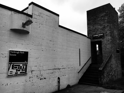
The road divided in Blackheath, the route of Watling Street contested from here on. Certainly, the southern fork, towards the Sun in the Sands then continuing as the A2 into London was a straight, direct route which resembled the traditional course of a Roman road - but the northern fork towards Greenwich seemed a more likely candidate for my walk. Driving directly ahead onto the scrubby and attractive fringes of Blackheath, the road passed over the seething concrete gully containing the Blackwall Tunnel Southern Approach Road and abruptly entered the charming village centre of Blackheath. Pleasant local shops lined the walk up to the busy junction beside the Royal Standard pub, and it was easy to see why this had become such a desirable address in recent times. I continued heading west into Vanbrugh Park, named for architect and bawdy playwright Sir John Vanbrugh who built his home, Vanbrugh Castle, nearby on Maze Hill. Initially, the streets were lined with imposing townhouses as I'd expected from an area bearing this distinguished name, but as I approached the Heath I noticed a block of low-rise, modern dwellings presenting their rather stark rear aspect to the road. Vanbrugh Park Estate was designed by Chamberlain, Powell and Bon - perhaps better known for their work at The Barbican and Golden Lane Estate in the City of London - and it was possible to see the germ of these later developments in this mix of housing types and dedication to vigorous modernism. The two-story houses which abut the Heath formed a square, looking inwards to narrow streets and walkways along the blocks. Behind these, a taller block of four distinct towers interlinked with decks and stairways rose over the houses, with distinctive corner windows giving the building the appearance of hanging from an external skeleton of concrete. Everything was separated by well-cared-for green space, and the area felt quiet and serene. Most of the homes were now privately owned - and given their heritage, much sought-after nowadays. It seemed surprising and brave to locate something so modern and incongruous on the edge of ancient Greenwich and so close to the open, and in parts still rather wild Blackheath. It seemed stranger still to cross the street and delve into an opening in the wall of Greenwich Park...
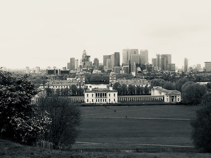
There have been recent reconsiderations of how Watling Street entered London, and the route around Greenwich in particular has been disputed. A Romano-celtic temple was discovered in Greenwich Park in 1902 and has been re-excavated in recent times to suggest it was of considerable importance. In use from around CE100 the site was very close indeed to the straight line I was attempting to strike through the park, roughly continuing the course of Watling Street which I'd walked in from Dartford. Distracted by the beautiful rose gardens and the impressive old trees, I continued uphill towards the Observatory with a growing admiration for the area. I felt like a fool in fact - I'd assiduously avoided Greenwich Park for years, once staying close to its gates but refusing to walk uphill for fear of the throng of tourists I'd seen pouring out of the gates. I'd fallen victim to an inverted snobbery which I now realised was foolish. The park was busy, the queue to visit the Observatory certainly long and tedious, but the view to the south was utterly spectacular - and entirely free of charge. Up here, gazing across the hazy and sombre shadows of the Isle of Dogs and regarding the silvery curve of the Thames I was reminded of Joseph Conrad and 'The Secret Agent' and the tale of a 'dynamiter anarchist' attempting to stop time which inspired it. The park had always been busy, always a focus of London life - of world attention no less. It made sense that Watling Street - or at least a significant branch from the road - would have passed into the park and towards the river at this near-perfect strategic viewpoint over the Thames Valley. Below me, the buildings of the Royal Naval College spread out in formal squares and courts, the sun gleaming from the Portland Stone and shimmering over the lead domes. My walk had begun in inauspicious Dartford, a place seemingly devoid of promise, and had ended here in a picture-book view of London spread out before me. I carefully picked my way down the steep path and out of the gateway into Greenwich. The sudden burst of activity felt disorienting and strange. People swirled around the tiny pattern of streets, dodging between beer gardens and street food vendors. Traffic nudged impatiently through the crowds, attempting to assert its right to dominate the old thoroughfares. Tourists ambled without apparent targets, gazing at guidebooks rather than the road at their feet. In the midst of this, the cool, dark churchyard of St. Alfege called me - Hawksmoor's most understated design perhaps, but still austere and impressive despite the lack of the octagonal west tower he planned which would have made it a southern cousin of St. George in the East. The garden felt damp, ancient and distinctly riverine under the tree canopy. It was also oddly silent despite the nearby thrum of traffic and people. This felt like the right place to end my walk.
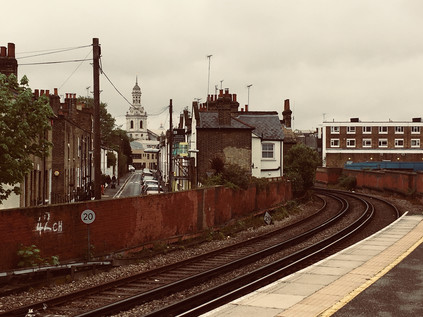
From the platforms of Greenwich station I looked back east, the curve of tracks framing the church and the tumble of buildings which fell towards the bank of the Thames. I'd found myself here twice in recent times, and realised that during my one brief stay here I'd barely done the place justice. Despite a liking for the place, I'd often skirted around Greenwich like it was an inconvenience, ignoring the history which seeped from the ground and preferring to look north, away from the park on the hill. It had taken an ancient road to bring me here, a road walked long before the Romans and one which was almost ingrained into the land by continuous use. Somewhere between the ascent of Shooter's Hill and the descent from Greenwich Park I'd made sense of the walk and found a way to begin to read the southern geography at last. I boarded a train bound for Cannon Street where London Stone should be, but currently wasn't. I was still following the most ancient of ways...
You can find a gallery of images from the walk here.
Lost::MikeGTN
I've had a home on the web for more years than I care to remember, and a few kind souls persuade me it's worth persisting with keeping it updated. This current incarnation of the site is centred around the blog posts which began back in 1999 as 'the daylog' and continued through my travels and tribulations during the following years.
I don't get out and about nearly as much these days, but I do try to record significant events and trips for posterity. You may also have arrived here by following the trail to my former music blog Songs Heard On Fast Trains. That content is preserved here too.
