London's Green Fringe: The River Ingrebourne
Posted in London on Saturday 5th November 2016 at 10:11pm
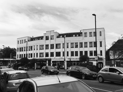
I stood, shivering at the bus stop in the middle of a group of mildly disgruntled passengers. We'd been here for a while, despite being told that the replacement bus service was 'just around the corner' several times. A Transport for London employee conversed urgently with a representative of Ensign Buses who was nervously checking his smartphone screen frequently. A light drizzle started to fall. I hadn't begun my walk yet - but I was already close to turning on my heel and heading back to the city. It hadn't been a great start - the slow slog along the alternative route from Bath to Paddington had been a minor irritation - arriving a half-hour later than usual in London was tolerable in itself. I also knew that the line from Liverpool Street to Shenfield was closed for platform lengthening work - and I'd factored that into my plans. I'd be putting boots on the ground much later than I'd usually plan to be, but if I pushed through the range anxiety which a late start causes, I could still manage the planned route. I'd even managed to commit an annoying cold to the back of my mind - I was still coughing furiously at times, but considering I'd only been nursing the symptoms for a few days, I felt surprisingly ready to tackle a walk. But now I was stranded in Chadwell Heath, an unprepossessing corner of Greater London which has Essex aspirations but none of the means to back it up. A bus finally lurched up to the stop - but another train had arrived now and a stream of passengers ambling along the footpath broke into a trot at the sight. Those of us already at the stop crammed desperately onto the double-decker the moment the last straggler had cleared the decks. The bus was warm and reeked of wet coats and over-deployed aftershave, its windows dripping condensation already from the fresh crush of humanity on board. We set off through the long sprawl of takeaways and suburban pubs towards Romford where the bus mercifully decanted most of the passengers. A few of us soldiered on east - along the curiously named Squirrels Heath Lane towards Harold Hill. This is where I would start - at Harold Wood station on the very fringe of built-up London, an area which until 1965 was resolutely part of southern Essex and has continued some of the less savoury traditions - not least the curiously violent history of the area, with numerous unrelated murders and attacks over the years. Now, it's on the up again - the large swathe of post-war residential areas is improving and the little parade of shops outside the station was busy and varied. A local initiative known as Harold Hill Ambitions oversees the regeneration. For now though, my own somewhat humbler Harold Hill ambition was simply to start walking. Later than I'd like and still with some concern I'd struggle to complete the route today, I headed up the slope by the closed station where a long bus queue was developing for the next heaving double-decker to Chadwell Heath. It was time to set off in earnest.
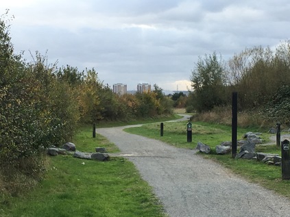
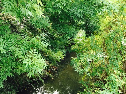
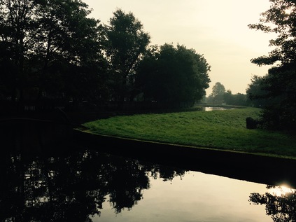
Once I'd set off and settled into the welcome rhythm of walking, my mood improved. I'd almost forgotten the purpose of today's walk - to chart the course of the tiny Ingrebourne River, one of the easternmost tributaries of the Thames to run through Greater London. It begins its surprisingly long journey out in Essex, on the fringes of Brentwood where it meets the Weald Brook before turning east, passing under the M25 and skirting Harold Wood. I'd looked at the possibility of starting my walk further out near the Motorway - but transport beyond the railway was sparse and time was now a limiting factor. Instead, I turned east after crossing the railway into the quiet backstreets of Harold Wood. A corner store selling car paint was decked out with England flags and UKIP stickers and I fought hard to push the preconceptions away. Here on the fringes of London lies this outer band of economically challenged but just-managing communities which edge a vast city of diversity and change. It's unfair to characterise this as an Essex phenomena - the halo of intolerance circles the city. But here on the eastern edges it sometimes feels more concentrated and close to explosion. I turned onto an unadopted gravel road which ran between lines of suburban semis and allotments. A bonfire crackled beyond the fence, while a group of dedicated diggers prepared their plots for winter. At the end of the track I was deposited onto a surprisingly busy minor road - the continuation of Squirrels Heath Road as it headed over the edge of London. A little to the east a low brick parapet gave away the location of the Ingrebourne at Cockabourne Bridge. The brook was bright and clear here, running over a stony bed and between green, wooded banks. To the east, Shepherd's Hill rose into Essex with a string of car headlamps shining in the gloomy morning. I zig-zagged across the lane and into a narrow driveway leading to Harold Wood Park, before turning east and finding the line of the Ingrebourne beyond the changing rooms and tennis courts. A path crossed the river and turned south - I took it and suddenly found myself out of London entirely. The city felt impossibly and completely distant. The air was clear and quiet, and the sky was a band of grey with a promising flash of blue beyond. As I walked, following the twisting course of the river in its green trench, I realised I was entirely alone out here. The dog walkers had evaporated away towards the car parks, and the only sound was the satisfying crunch of my boots hitting the path on the edge of the woods. I let my pace slacken a little, enjoying the sense of isolation and savouring the pangs of uncertainty which always hit when I feel I've left the gravity of London involuntarily. The morning was surprisingly mild and was staying dry. I wasn't sure what I'd expected of the tiny Ingrebourne but this was a surprise.
As the Forestry Commission's well-maintained path divided I was faced with a choice: head west, and leave the course of the river to detour into more urban territory before regaining its route, or to head east and stick a little closer to the water. I turned east and soon found myself on the busy rat-run of Hall Lane. Despite being a relatively minor and almost rural route, this lane provides a back route between the suburbs of Harold Wood and the larger urban centre at Upminster, crossing the busy A127 Southend Arterial Road at a sprawling junction. The brief section I walked was busy with vehicles but thankfully supplied with a decent footpath. The lane rose gently as I walked south with farmland to the east, and a view over the surprisingly deeply carved valley of the Ingrebourne to the west. Across the valley I could see the distant spire at Hornchurch and stubby towers of housing dotting the hills towards Romford. It felt odd to be looking in on London like this, seeing it as the next village over the hill. A growing hum proved to be traffic on the A127, carving in from the east in a deep gully with sweeping slip roads joining my route here. I climbed the curving path beside the litter-strew bank to find myself above the main carriageway. The rush of traffic was oddly exhilarating after the silent countryside, and the views towards the west suddenly revealed the distant misty shades of London's city skyline which felt alarmingly remote. After descending from the overbridge my path left Hall Lane briefly to skirt the access drive to a row of large, very expensive looking villas with a range of luxury cars in their drives. The link between the wealth of the distant city towers and the assets arrayed along this quiet lane was suddenly very clear and very direct.
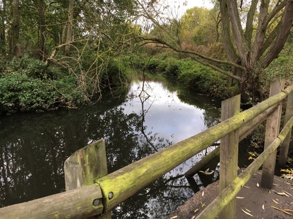
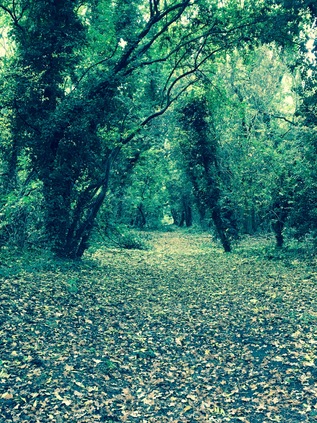
The footpath along Hall Lane was officially part of the London Loop path, which I'd find myself following fairly faithfully from here onwards. I was a little ambivalent about this - my walks were supposed to follow the topographical and historical pathways I was curious about and I met all too many people who were set on covering the various mapped and signposted footways around Britain as something of a ticking-off exercise remote from any local interest. I'd been asked "are you doing the London Loop?" often enough to somewhat shudder at the rather glib, middle-class 'in group' of walkers who hefted their poles and wore designer ski-wear to navigate paths within the M25. I also imagined that the London Loop was, like much of the Thames Path, a greatly improved and well-appointed route which would be busy with walkers at all times. This wasn't always what I wanted, and I'd grown used to solitude on these rambles. My experiences over the next hour were to challenge all of those assumptions - and to diminish some of the snobbery I'd somehow found myself deeply mired in, exchanging it for honest English mud. I left Hall Lane to gingerly totter down the steep hill of River Drive. This was a street of fine mid-century houses which climbed down the steep edge of the Ingrebourne Valley between vintage lampposts to meet woodland at the end of the cul-de-sac. When I reached the bottom I squeezed through a narrow gate with a London Loop marker on it, and plunged deep into woodlands. The trees closed over me, and the floor was a sea of autumn leaf-fall. It was eerily quiet and pleasantly cool as I pressed on, thankful for my good boots and treading very carefully over the buckling roots of trees which crossed the path. For a good distance, the path was only a footstep wide, my left boot splashing into a shallow stream which had carved deeply into the muddy ridge on which my right foot was determinedly plodding. I realised that this was some unmarked tributary of the Ingrebourne, which I was soon to cross on its own narrow wooden bridge. The river was still flowing fast and clear here - a reassuring presence after a rather sudden venture into wilder lands. My path continued, sweeping to the south and into a field of horses which I assiduously avoided. Looking back, the rising woodland sloped away into the distance, back to my starting point at Harold Wood and beyond. Ahead, the still remote church tower slipped across the horizon as I edged around recently harvested stubble-fields on a rough and narrow pathway. This was more challenging than I'd imagined my walk, and much less 'improved' than I'd suspected the London Loop would be. Oddly though, I found myself entirely enjoying this surprisingly rural edgeland ramble. I could see the built-up fringes of Upminster beyond a distant school field and the rough walking was exhilarating. I left the path to stalk through some longer grass to the river's edge, speculating that this would have been tougher going in the Summer as I trudged over decaying nettles which would have been a waving field of potential stings just a month or two back. Eventually, the footpath ended beside an allotment and turned a corner into a litter-strewn gravel drive between some concrete garages. While I was sorry to leave the open fields behind, I was hungry and flagging a little, so civilisation was almost welcome as I navigated the backstreets to Upminster Bridge with its little cluster of shops around the penultimate station on the District Line. I grabbed a snack and headed over the river once again at a noticeable depression in the road which marked its valley.
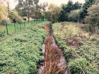
I was eager to find the Ingrebourne again, so I swiftly turned south into the quiet of Bridge Avenue which skirted the edge of Hornchurch Stadium, home to the local football club. The footpath I needed to pick up ran through the club's almost deserted gravel car park, entering a public park via a low gate and becoming Gaynes Parkway - a long, green route through the edges of Upminster which followed the river tightly. After a pause for lunch in the park on a convenient bench, it was good to be walking at some pace again. While the scramble through the woods had been surprisingly good fun, it was slow going and I'd begun to feel the pressure of time again. I recalculated the spots I could practically turn aside if time was short - but there were rather few from here onwards, and striking out for Rainham was by far the best option possible. The path was deserted in the grey afternoon, and I was able to stay close to the meandering Ingrebourne for a unusually long distance as it tumbled over weirs and through concrete channels designed to calm its flow when in spate. As the view broadened into a wide sweep of grassland to the east, the river divided into a number of channels and unnamed tributaries. The Ingrebourne's final stretch is a lazy wander through the flat bottom of a broad valley, where it spreads to feed wetlands and marshes hemmed in by higher ground. Much of the area has become Hornchurch Country Park, largely centred on the former RAF Hornchurch. This was the home of the squadrons of Spitfires which valiantly defended London's skies during World War II, but has a longer link to aviation. A giant iron RAF roundel set into the ground outside the Ingrebourne Valley Visitor Centre is inscribed with the dates of Sutton's Farm - a First World War airfield which requisitioned a large part of a local farm, but closed in 1920 and returned to peaceful pasture. The site was requisitioned once again in 1928 for the larger fighter base which survived until 1962, well into the jet age. Passing up a chance to explore the Visitor Centre and its inviting café due to my tight schedule, I pressed on into the park. A little weak sunshine was beginning to filter through the clouds in broad shafts, striking the wooded hills to the east with patches of bright autumnal gold. The path was busy with walkers, families on cycles and lots of dogs, and it was pleasant to be making a good pace despite tired feet. The former military role of the land was marked by the ominous concrete pill boxes and gun emplacements which were half-buried in grass. Their stark, empty faces now inert but a reminder that this was to a great extent the last line of defence for London. It was sobering to think how London had become a city under siege again back in 2012 and how normal it felt now to see armed police around the city. Strange times sometimes hark back to even stranger eras it seems. Deeper into the park, the stream of walkers thinned and only a few more dedicated souls passed me by. The path took an abrupt westerly turn to skirt the lake at Albyns Farm, dotted with tiny islands which waterfowl flitted between. The path soon turned into a narrow road which led to the farm houses. The impressive houses sat behind high electric gates, an array of expensive vehicles ranged along a rank of large garages, and low-roofed windowless sheds kept locked and bolted. This felt like the kind of spot where you should just walk on and not ask questions - just remote enough to be unobserved, but handy for the M25 when necessary.
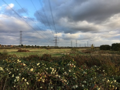
I recalled my imagination from its wandering, and focused on my own journey. Here I faced a final choice about how my walk would end - I could press ahead, return to civilisation and walk on pavement to my destination, or I could turn south again via a gateway in the drive, back into the grassland. I opted for the path to the south, which began as a beaten down edge of a broad field which rose slowly to the south. At the western edge of the field it turned through a gate and became a more formal, rough path which continued to climb towards the southern horizon and, remarkably enough today, a sudden break in the clouds. This was Ingrebourne Hill - not really much of a climb, but by far the highest point around for some distance. The tangle of channels and ponds which the river had become slunk around base of the hill, fanning out to supply the wetlands which carpeted the valley. I soon reached the summit and turned a full circle to take in the view. The clouds had parted to let a golden, autumn sunset begin its gradual progress and the farmhouses and fields which I'd walked from the north were bathed in sudden glamour. The trees, climbed away from the valley towards my starting point - a string of distinct but connected green spaces with the river at their heart. If the plans which the London Borough of Havering have tabled ever come to fruition, this chain of spaces would be broken into parcels, some destined for new development. The green belt unbuckled in the east, the city allowed to leak out towards the skies of Essex. To the south of my hilltop lookout the faint line of the Thames shimmered on the horizon while the factory buildings which lined Rainham Creek towered above the range of pylons and mid-rise housing blocks. To the west, a haze blocked the city from view entirely - but to the east the vast plain of low-lying marshland which stretched along the estuary seemed to run on forever, broken only by the slender grey line of the A13 slinking across its vast, green breadth with a trail of red taillights disappearing into Essex. I trudged downhill, towards the road to Rainham.
Despite having another mile or so cover to reach the station, I was confident I had plenty of time. I was moving more slowly now, heading for the Red Bridge at the roundabout where I knew I'd cross the Ingrebourne for one last time. After paying my respects to the river as it began the final twists towards the Thames, I took a different route to the station from my previous treks, walking along Broadway, Rainham's surprisingly interesting village High Street. The squat, businesslike Norman church of St. Helen and St. Giles stood in simple counterpoint to the formal Georgian brickwork of Rainham Hall sitting upright beside the road. Both faced up against a charming street of homes, shops and inns which seemed to tumble together, some of them in the white painted weatherboard typical of Essex. As I approached the station I pondered if I had time to make good on a foolish promise I'd made to myself before today's late start had interfered with my plans. During a tidy of an old piece of furniture we'd retrieved from my parents' home, we'd found a spare set of keys belonging to my mother. I'd turned the wooden 'Scorpio' imprinted fob in my hand as I'd travelled to London and I'd resolved that the keys should find their final home where I'd tossed Dad's set at the beginning of the year. So, I found myself once again striding out along the path across Rainham Marsh, the bright afternoon sky having turned to a purple-grey churn of cloud with a wild wind thrashing at the stems of reed which lined the Common Watercourse - one of the many channels running into the Thames where it met the estuarial Ingrebourne. I stopped at the spot where I'd gazed across the marshes months ago, and summoned the resolve to slip the pair of keys off their ring. Without daring to hesitate I tossed them into the dark waters, breaking the bright green algae-covered surface. Slowly, the ring of clear water opened up by the keys began to diminish, the green carpet almost covering the surface again. I laughed a little at myself - this strange, sentimental ceremony at a spot which meant nothing to my family as such, but which had come to mean a great deal to me. A place where for centuries people have left the secrets they don't want rediscovered - but for me a place of remembrance. I looked out across the darkening marshes following the line of electricity pylons until it merged into the elevated route of the A13. There was an incomplete walk out there somewhere, but my business here was done. I turned and headed back towards the station, the wooden key fob held tight in my pocket. Back in February leaving the marshes had felt like an ending - when in fact it had been the start of a long year of goodbyes. It had taken me a long time to feel ready to even start saying them.
You can see a gallery of images from the walk here.
Once again it was a privilege to be out early. A privilege too to descend from the former Great Eastern Hotel to the platforms at Liverpool Street for an early train - an experience I've long coveted and was glad to finally manage. The vast building edges Liverpool Street, wrapping a modern, sleek hotel inside a Victorian marvel and losing none of its charm in the process. Somewhere in the core of this network of restaurants, ballrooms and corridors was a hidden Masonic Temple which doubled as a venue. It felt like a strangely magical place, with signs which were projected onto period walls and ceilings which disappeared into the tall core of the building. Outside was a dark but thankfully dry street with only a short stretch of moderately grease-slicked pavement to navigate past McDonalds and into the station entrance. Largely free of Crossrail works at last, the hotel has regained its splendour and a little of its mystery. Many of my adventurous excursions had started and ended here at Liverpool Street - but perhaps never quite so early or in such style. After finding food and coffee I boarded the train to Enfield Town. There was a dull flicker of light in the sky, and a surprising crowd developed on the train as we sped north along the Lea Valley. My plan for today had only formed in the last few hours before sleep - there was unfinished business in the north, indeed not far from the origins of my most recent river walk...
Enfield was just waking up as I headed out of the station and into town. I slipped into a coffee shop which had opened minutes before and chugged one last hit of caffeine before setting off in earnest. The suburban High Street which I'd walked between Enfield Town and Enfield Chase stations once before was little changed, and felt less like London than ever. I began, counterintuitively by heading west. As I climbed towards the crossing of the New River, that ever present waterway which has slunk mistily through my recent wanders, I recalled my reaction at repeatedly crossing and re-crossing it on my prior visit - never realising quite what a central feature it would become in my wanderings years later. After the lines to Kings Cross passed overhead at Enfield Chase station, the road began to rise more steeply. I was climbing out of the broad Lea Valley, onto the heights that supply the tributaries on its western side, and which my recent perambulations have repeatedly haunted. The houses became larger and less cluttered together and looking back I could see Enfield sprawling east towards a green middle-distance on the other side of the valley. Ahead, the road dipped again into the gully driven by my target - the Salmons Brook. I'd rather foolishly decided that I needed to head for this crossing - somewhere between Enfield and Oakwood on the road to Cockfosters - for two reasons: firstly, because beyond here the brook meandered into open country and beyond to the M25 - this really was its first contact with London. Secondly, because I couldn't quite resist beginning a walk at a place called World's End. At the foot of the hill I found the brook passing under the surprisingly busy road via a brick bridge. Traffic hurled passed as I crossed to look into the misty middle distance beyond London. The brook curved away, hidden in a line of trees. South of the road it formed the boundary of an expensive and very private golf course. This was going to mean a long detour to pick up the route. In the event, World's End wasn't entirely as apocalyptic as it sounded - consisting mostly of a sprawlingly large chain pub and a rank of suburban shops. I plunged between them, into suburbia. My walk was beginning where the world ended...
The extent of my diversion became apparent as I trudged by a large complex of schools which flanked the golf course. Once again I was heading uphill, having been led astray by what looked like a way into the park beyond the school but which was in fact a large patch of waste ground. It was still quiet and aside from a fairly gregarious population of squirrels, I was alone. Except of course for the occasional car of early shoppers heading for the vast Sainsbury's which appeared to be tucked discreetly out of sight behind a range of imposing brick frontages. This was Highlands Village - an 'executive estate' which had grown within the solid, institutional confines of the former Northern Hospital - locally known as The Pesthouse likely due to it sharing a site with Enfield Isolation Hospital. It seems the very edifices which were built to keep inmates safely within were now being used to keep undesirables out, with the carefully managed estate a sea of CCTV cameras. I decided against an early shopping trip and pressed on along World's End Lane to its junction with a familiar thoroughfare - Green Dragon Lane - starting its journey eastwards to meet Green Lanes at Mason's Corner. Once again, I marvelled at the unintentional linking of my various walks.
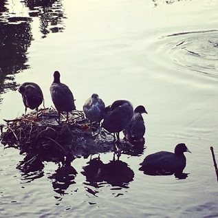
As I turned east I noticed I was playing a game of informal tag with a TfL van cruising the local bus stops to paste up diversion notices. I've always been weirdly embarrassed at repeated encounters like this, wondering what the likely unassuming other party will think about the fat, balding pedestrian stomping along and repeatedly catching them up. I noted with some dismay that the van turned ahead of me into Vera Avenue. I was heading this way too - because it finally got me back on track. Beyond the estate of early 20th century houses and bungalows Salmons Brook headed south east, leaving the golf course and crossing my path up ahead. I finally shook off the TfL worker as he sped away under the railway bridge at Grange Park station, where I'd alighted just a few weeks back to walk Green Lanes. From here, for a while at least, the territory was familiar so I settled into enjoying the walk. When I reached the busy crossing of Old Park Ridings I took a short detour north to the parapet over Salmons Brook. I'd been ridiculously close to this on my previous visit, but hadn't spotted the tell-tale low brick walls. The brook was a slow but steady trickle, largely clear and free of obstruction here. I headed back to my route, pottering along the same suburban streets I'd walked so recently until I came to Bush Hill. It was here that I'd looked north along the long, straight track realising it was a natural continuation of Green Lanes. Today though I turned that way with a vague intention of seeing if I could access the New River, the familiar green bank of which skirted the eastern edge of the street. Moments into the walk I discovered a curious stairway leading down from the street towards the back gardens of houses below. Figuring that Salmons Brook must pass below nearby I chanced a walk down its litter-strew steps and found myself above the brook, looking into a surprisingly ornamental stone arch. I had stumbled across the Clarendon Arch - the oldest surviving structure on the New River and something of an engineering marvel. Erected in 1682, the arch carried the brook under the New River, replacing a lead lined wooden aqueduct which had previously and precariously transported Myddleton's waterway overhead. Extended to carry a sizeable extension the embankment and Bush Hill, the portals had been re-erected and with some restoration work early this century, the structure still allowed the tiny brook to flow unobstructed. On the tiny damp viewing platform, looking into the dark tunnel I wondered how many people bothered to step down from the street to see this. I'd wager few, with most visits apparently confined to littering or illicit urination given the odour of the place. Almost opposite the stairs was a kissing gate leading onto the bank of the New River. I climbed up, and surveyed the misty view. A little weak sunshine was breaking through over the city, and the hazy morning view of ducks and green-tinged ripples was accompanied by absolute silence. It was hard not to linger here for longer.
I followed the river around the corner, returning to the streets at Bush Hill Road. I then turned immediately south into a quiet housing estate to get as close to the line of Salmons Brook as possible. The estate opened into a pleasant surburban street called Berkeley Gardens which deposited me at the end of Ridge Avenue, close to where the brook crossed under the street. I detoured south, planning to make my crossing above the water, and found the brook now in culvert. To the west, a concrete access ramp ran along the line clearly distinguishable line of the waterway and, after a fraught crossing of the road, the eastern course was marked by a rough, litter-strewn grassy void between houses. I felt further from the water than ever and began to question how much I'd actually see of Salmons Brook today. Whatever I did now, I'd have to circle the route which the brook took across the suburbs here. I opted to head south along Church Street, and then onto Little Bury Street which would allow me to cross the brook again. This time, tucked into the narrow street which was little more than an access for Edmonton County School, I found the brook trickling in the open air under a tiny bridge and evidently subject to ongoing works to shore up its broad banks. Encouraged, I turned east again with the intention of exploring Bury Lodge Gardens. This urban park is divided into two distinct parts - a formal garden, carefully laid in colourful and seasonal beds with arches and structures for climbing plants around tidy pavements and benches, and a rough grassed area leading down to the brook. I crossed both and found myself separated from the dark water by a palisade fence. I wandered the edge of the park before finding myself back on Bury Street West and pounding the footpaths once again. I was beginning to feel the effects of the walk, and with the brook now running some way to the south, I found myself beside the rush of the A10 at a tiny parade of shops. The main road curved away to the south, cutting across allotments which entirely enclosed Salmons Brook, while ahead of me lay the edge of Edmonton.
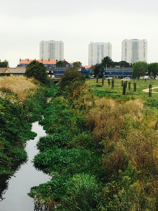
I've managed to avoid walking in Edmonton to any great degree. That's not by design, more because my routes tend to radiate in or out of the city along the valleys carved by rivers or roads, and Edmonton sits squarely between these. From the river towpath the only great landmarks are the tower blocks at Edmonton Green which glower over the suburban streets, along with the audible and olfactory footprints of the vast waste incinerator. However, Salmons Brook cuts directly across the area on its journey to the Lea once I'd crossed the Great Cambridge Road I was very clearly in new territory. I plunged into suburbia almost eagerly - there were points here where the brook ought to be visible before disappearing underground, and now the clouds were closing in overhead the streets offered a relatively sheltered walk for a while. As I zig-zagged into Rugby Road I was halted by the sudden presence of one of the Edmonton Green towers directly ahead of me. Even at a distance it seemed vast - Pennine, Mendip and Grampian House are each twenty-five storeys high and almost exactly the same age as me, their survival stemmed from Enfield's policy of renewal and refurbishment. Among the tiny red-tiled roofs of the side streets with every possible space crammed with homes, the towers seemed cold and glassy, dark sky visible through their open-cornered balconies. I set off again, and note by a trick of perspective that the towers soon disappear. I wonder if I've been witness to some sort of suburban mirage? For the first time here I find myself doubling back too - a public footpath covering the route of Salmons Brook crosses west to east here, but I don't take it imagining my walk will be better served by taking the long way around. Instead I return and take the path, a concrete phantom of the brook beneath, which deposits me at the foot of an almost worryingly decayed footbridge over the railway. I pick my way through the fly-tipped detritus which lines the path and gingerly ascend the rotting wooden steps. The high, narrow bridge deposits me in a similarly filth-strewn alley which opens onto a similar suburban street - but a notch down the ladder of gentrification. I'm being trailed by a black BMW which shudders with the low-end of an unidentifiable post-musical emission. For the first time in a long time I feel paranoia creep over me and I taste the metallic tang of adrenalin. The car slowly passes, the driver disdainfully regarding me as it slowly bucks over the speed bumps before screeching the few yards to the next set of traffic-calming measures. I turn gratefully south, following the railway towards the now ominously overbearing towers. The street becomes semi-industrial, and amid the car repair units and storage spaces I spy a small bridge over the brook. The view opens, into a wide, unused and likely unusable space between new and old developments and suddenly, in the midst of it Salmons Brook emerges in a concrete trough. I can walk its bank for a few yards, ignoring the hi-vis clad lurker smoking away his work-break where an Environment Agency access ramp leads down to the culvert. The stream is greenish and clogged with branches which snag on the concrete beam dividing the channel in two, but this doesn't dissuade a small cluster of birds from resting on the driftwood. Up ahead the stream disappears into a black tunnel opening above which is the partially refurbished Edmonton Green shopping centre. The tower blocks lean over me at close quarters, and the strange paranoia isn't diminished by proximity. Crossing the busy street and navigating the bus station leads me to the entrance to the shopping centre. The outer layers of the centre are tidy, shinily clad walls of reflective colour, but once under the bulk of the towers, the inner concrete shell is revealed. The walkways open into a vast covered market with a glass roof through which a jagged, staggered vision of the towering blocks fractures. I turn aside and walk a slightly crestfallen precinct towards a huge ASDA which appears to have landed beside the centre.
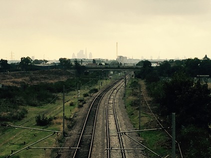
After stocking up on provisions I turn east again, figuring that the walkway beside ASDA is in fact the line of the Brook. At the end of the pedestrianised zone at the crossing of Plevna Road, I'm rewarded with a view ahead of a long, open stretch of waterway with a surprisingly tidy, recently built path beside it. The sky is a dark, purple churn of clouds now and I'm amazed I've not been caught in a shower yet. The low autumn sun has almost completed an arc overhead during my walk, and now I find myself walking towards an inky sky in the east. The path is long, straight and largely free of other pedestrians once I'm out of the gravity of Edmonton Green, while the channel containing the Brook is carved surprisingly deep and already cluttered with debris in places. The path runs tightly along the northern edge of a cluster of cemeteries, the largest being the privately owned Tottenham Park which opened in 1912 as a pauper's graveyard. This cemetery now appears to be mostly populated by Middle Eastern family graves, while a rotting and forlorn chapel crumbles among them. I snap a picture - white marble and crescent carvings set against the brick and verdigris of the chapel - but realise that in the wrong hands, it would provide the perfect out-of-context symbol for the far right. Tucked in a corner of the site is Edmonton Federation Cemetery, a somewhat earlier patch reserved for Jewish burials opened in 1889 on land donated by Lord Montagu. His name lives on in the busy road passing the site, and in the recreation ground across the street which doubles as a flood control area for the brook. Opposite the understated cemetery gates and sandwiched between Montagu Road and the Lea Valley railway lines, the green space is overshadowed by the reek from the Incinerator nearby. I walk the line of the brook until it disappears under the railway, turning south to circumnavigate the pools and hollows designed to manage the brook's surging waters when storms hit. Looking back west across the largely flat suburban landscape, the towers of Edmonton Green still loom large. It feels like there is no escape from their gravity. A little rain begins to fall, and I find myself trudging along a street of industrial units, the pavement slick with a coating of old dust and fresh rainwater. Back on Montagu Road I turn south, noting the long straight path leading back to the shopping centre, occupying the route of the former railway to the remarkably named Lower Edmonton Low Level. The crossing gates here are long gone, but the ghost of the railway is preserved in the arrow-straight footpath. The rain is falling a little harder now, and I seriously consider calling it quits at the next bus stop. It feels like the Lea's tributaries might defeat me again - so, of course I don't, and as a single-decker bus splashes past me without stopping I resolve to push on. A low drone up ahead signals the arrival of my old friend, the North Circular. Sweeping in on a viaduct, it stoops only for long enough for sliproads to join its main carriageway before arcing east over the Lea Valley. At the end of Montagu Road some sorry-looking but clearly once grand buildings are boarded up and marked for sale, but I can't imagine who would buy them with the concrete road mere feet from the upper storeys. Across the street is an entrance to the rather forlorn looking Kenninghall Open Space which occupies an oddly shaped island of space between the roads which loop up to the North Circular. I cautiously wander in, finding myself in a surprisingly quiet tunnel of green which appears to be abandoned. Broken benches harbour litter and the path cracks as roots strive for air in the polluted ground. The path curves south and delivers me to the base of the bridge. I cross the street and make a speculative but ultimately pointless detour into Albany Road which rather than leading to what appeared to be a patch of promising wasteland, now ends at the muddy security checkpoint outside a new development site. I retrace my route to the flyover, tired but at least drying out now, and climb the slip road. The view from the bridge is remarkable - a retail jungle to the north with a Premier Inn besieged by the tangle of roads, shuddering with the traffic. Looking south, a broad open marsh runs along the course of the railway. In the hazy distance, swathed in low cloud and ominously back-lit, the shapes of city towers can just be made out. A family who I've passed on the ascent re-cross my path once or twice as I stop to take pictures. A curious young boy, hangs back to watch me pointing my camera at the horizon. When his mother notices the tug of his arm on the pram as he dawdles, she turns and spits "Don't look at the weird man, he's takin' pictures of nuffink!". Half way across the bridge, I spot the curve of concrete emerging from under the road. This is another old friend: Pymmes Brook, and this is part of a walk I should have completed a month or two back. The Brook makes a tight left turn in the channel and passes under the staircase which descends from the bridge to the carpark of Tesco Extra. I descend, the smell of the slow moving brook beneath rising to meet me. Anyone who sees me here now, smiling like an idiot as he links up the geography of this retail park landscape, would likely worry - either for themselves or for me. My flagging energy returning, I make a brisk beeline for the store.
The last leg of the walk is tough going physically, but is surprisingly rewarding nonetheless. Thinking how far away the heights of Enfield seem now, I navigate the access roads from Tesco and head for the vast blue cube of IKEA. Their entrance road is flanked by broad, well-surfaced pavements but oddly the fence encloses these, leaving a gap only wide enough to accommodate the carriageway. I slip around the gate and walk close to the hedge and fence which divides me from the brook. At a point somewhere behind this fence the Salmons Brook and Pymmes Brook converge and form a single channel heading for the Lea. I can't formally honour the confluence - but I find a clear gap in the hedge where an access gate opens onto the brook and poke my camera through. I see the familiar concrete two-channel trench leading off into the middle distance. As I pick my way back to the road through the patchy and poorly-established grass of the verge, two adolescent IKEA workers approach me. They're dry-mouthed and clumsy with acne and apprehension as they ask what I'm doing here? I try to calmly explain that I'm taking pictures of the brook - one begins uncertainly "What brook?" but the other quickly and more confidently splutters out "You can't, it's our property". Amused more than annoyed, I carefully point out the Environment Agency signs, and they counter with "But you're on our land". I explain that I can't imagine what I'm doing wrong, but that I'm leaving anyway. As I wander across the car park they insist on escorting me to the edge of the site, walking solemnly a few steps behind me, looking at the pavement and resolutely not conversing with me. I don't rush - but as I pass the bus stop I see them back at the gateway, waiting for me to leave. They look mortally embarrassed and out-of-place in their gaudy blue uniforms which belong inside among the colourful plastic salad tossers, rather than out here against the grey skies. It's a short walk to Leeside Road where I turn aside and head for the Pymmes Brook Trail. Walking through Tottenham Marshes between the canal boats on the River Lea Navigation and the channel which contains the collective waters of two of my incomplete walks now, I'm on familiar ground. I've walked this valley before, and I know the terrain. My feet feel heavy and tired, and while I'm eager to fall onto a train, I'm equally reluctant to stop walking today. I think about continuing to Lea Bridge, or even further - but common sense prevails. I'm tired and I need to make sense of the walk before I head back to reality. The path twists its way into the narrow strip of land between the brook and the River for a final stretch and I decide to walk on, under the road bridge at Tottenham Lock, to the point where four summers ago I'd first spied Pymmes Brook leaving the Lea. A boom trapped the water leaving the brook, gathering little islands of twigs with halos of coruscating pollutants. Waterfowl leapt from island to boom and back while the brooks churned against the plastic barrier, unable to complete their journey until the floods came again. My journey though was done. I regrouped my aching limbs and climbed slowly up the towpath steps back to the road to head for Tottenham Hale station. Once again my walk had brought discrete topographies into alignment. I felt like I understood the valley just a little better. It was time to head homeward.
You can see a gallery of images from the walk here.
Growing up in the relatively rural westcountry, there have been few enough occasions where I could open an entry here with a Ballardian broadside. But today I woke up on the tenth floor of the Premier Inn which towers over Westfield. From the narrow window in my eyeline as I oriented myself to where I'd awoken, I could see the truncated bowl of the London Stadium surrounded by precariously slender, nascent towers with cranes still embedded in their steel and concrete cores. The sun was slowly rising behind the hotel, casting a strange shadowy light over the dusty building site which marked the boundary between the mall and the Olympic Park. Moving to the window, I took in the panorama to the west - sweeping from the copper flashes of autumn sun on the glass of Canary Wharf to the purple bruise of high ground in the distant north. In the midst of this, the green waters of the River Lea and its tributaries appeared oddly luminous in the morning light. Last night, as I'd dozed after too much good food at Lance Forman's place on Fish Island, the lights on the stadium had malfunctioned. The claret and blue neon winked out WEST Â Â Â UNITED. As their first official day of playing at the stadium came to a close, ham, it seems, was off. I dressed swiftly, heading down to the ground floor and into the chilly October morning. I had no plan as such, and no real goal in mind. It was enough to be out here on this much raked-over ground so early. I skirted the car park and the concrete trough bringing trains to the International Station, and found myself walking the ghost of Waterden Road. This empty street, wheeling in from the midst of the retail complex wasn't the road I first knew - but it covered the same ground.
At the river crossing, I headed down onto the silent towpath by way of a steep staircase and passed under the road. The emerald waters rippled as birds took flight on my passing, and the reeds swayed in the ebb of the stream. As the sun began to climb, forcing through a dull morning mist, the scene began to take on colour - the swaying grey mass atop the bank revealed itself as a sward of yellowing marsh grass. The summer's growth almost concealed the Olympic Rings, glowering over the area and staking their claim. I walked on, the yellow stone surface of the path making for a pleasant crunch to my step. But I noticed this coating which had made the park an appealing swirl of colour from above was looking threadbare. The underlying asphalt was exposed in places, the true industrial nature of the area returning to the surface maybe? Passing under the bridges carrying the tracks from the Lea Valley Velopark, I was aware of the approaching drone of the A12, with the swishing grass no longer managing to mask the sound. I took the path up to Eastway, emerging on a familiar corner. Across the street, Homerton Road led into the Wick Woodlands - and eventually to a what had become significant walk for me alongside the Old River Lea. Overhead a fading 'get in lane' sign for the IBC/MPC was partially whitewashed out. This junction had felt so impenetrable and inhumanly teeming with traffic on my last visit, but now it was eerily quiet. I turned east with the vague intention forming of taking a circuit back to Stratford via Leyton.
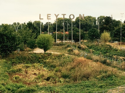
The early mist began to rise as I trekked along Ruckholt Road, remembering the desperately hot summer excursion I made along here during the Games. Today it was almost silent - with New Spitalfields Market closed for the weekend and traffic surprisingly quiet, I ambled along interrupted only by the occasional bus setting off from the nearby depot for the day. At the abandoned gates to Eton Manor I saw a temporary roadway slowly succumbing to nature behind the fence. The football pitches had been restored, and the lanes for guiding traffic into temporary parking slots were redundant, their patchwork of temporary paving cracking and dissipating. As I climbed towards the bridge which had nearly defeated me in the heat of Summer 2012 I took the opportunity to look north and east - it had been an unknown world then, beyond this edge of the park - but now I had a tolerably good idea of what lay beyond. Beneath me, the Dagenham Brook edged around Orient Way - Leyton's only partially ironic version of the 'Hollywood' sign on poles protruding from the greenery. There was a walk in this - linking the Olympic east with the edgelands I'd walked in more recent times, but for today it was time to turn south. I headed into suburban Leyton which began abruptly after the rail depot at Temple Mills. Suddenly I was in an avenue of victorian terraces, with only a corner site being redeveloped as luxury apartments to give away the proximity to the new megacity at Stratford. Soon, even the tallest of the towers around Westfield had slipped below the roofline and I was surrounded by a calm Sunday morning of aromas - breakfast cooked, washing steamed, dinners roasted. Ahead, the High Road was coming to life with a gentle whirr of traffic. Pedestrians lazily dragged suitcases up the rise over the A12 in its concrete gully towards the tube station - and I remembered gratefully sliding onto a cool trackside bench, dry-mouthed and with a racing pulse at the end of my previous walk. By my current standards it was a fairly short tramp that August day, but it came with the added jeopardy of being stalked by paranoia courtesy of LOCOG. Today the progress along the High Road beside the dew damp grass of Drapers Field was more leisurely. I passed tiny cafés peddling giant breakfast plates and my thoughts turned to coffee...
Over the railway lines I could see our hotel in the cluster of towers - it seemed I'd come no distance at all, circuiting the manufactured centre of Westfield. The road dog-legged crazily towards Stratford, rising over the railway near an old pub - still here despite being surrounded by nascent towers and concrete retaining walls. Below us, somewhere, the dead culvert of the Channelsea River ran dry and the old Angel Lane of pubs, schools and shops was similarly absent. Ahead of me Joan Littlewood's theatre seemed a gaudy scarlet against the beige of the old Stratford Centre. Nothing could be expected to bring this resolutely 1960s conception up to date - its winding service roads and jagged edges hinted at a time gone by and contrasted jarringly with the smooth curves and shiny surfaces of Westfield. Inside, the centre was deserted with few of its stores open until later in the morning. A few locals used it to shortcut to the station, skirting the market traders wheeling in ludicrously overloaded barrows. Even they couldn't quite figure the place out - artisanal bread duelling for space with poundshop 'phone cases. I soon burst out into a surprisingly sunny morning on the High Street - traffic hummed, people bustled, little had changed. I settled into the window seat of a coffee shop before venturing into Westfield to complete my circuit. I'd woken up with the city today, and was finally ready to face it.
The Route to Market - Walking Green Lanes
Posted in London on Saturday 3rd September 2016 at 11:09pm
It had been a troublesome morning... I sometimes wonder if Network Rail can tell when I really need to walk. It had been a difficult week, by turns sad and frustrating, and the opportunity to dispel some cobwebs and get out into London was welcome. As we came to rest in Swindon roughly on time, I somehow knew something wasn't right. I suppose that the ability to sniff out railway trouble is still somehow strong despite my long absence from the rails? In any case, as we finally left an hour later, even this hackneyed old rail traveller was surprised at the delay. I've never before had the entire service into London stop because a signaller couldn't be found. While there is no accounting for times when safety critical staff get taken ill, of course, the idea that no relief could be found thus stopping the job for well over 90 minutes aside from any residual delays, is startling. Somewhere in the midst of this I complained bitterly to a member of GWR staff that while I'm used to all kinds of delays and even relatively sympathetic when the railway suffers an incident way outside its control, this was pretty bad going. A nearby passenger decided to take me to task - I wasn't helping, it wasn't the staff's fault, did it matter if I was late getting to my destination? Well, despite noting that he probably wouldn't agree with my view - yes! Yes it did matter. I needed this walk. So when I finally arrived in London I wasted no time in getting over to Kings Cross where I knew there had also been early morning signalling issues. I quickly hopped onto a fast service to Finsbury Park which departed from the main trainshed - something I've not done for a good while. In just a few minutes I was disembarking and dashing downstairs, around a corner and up again despite what could have been a cross-platform change if the correct side doors were open. I decided as I collapsed into the all-too-hard seat of a tired looking Class 313 that things had been sent to cause maximum irritation today. I had to look at the positives - I was probably only an hour later than planned, and there was some slack in today's only moderately planned walk. Out of the window I could see some of the territory I'd be walking. Suburban rooftops and patches of parkland glinting green in the morning sunshine. Somewhere down there were hidden rivers, ancient tracks and unexpected corners. Things could have turned out far worse I suppose!
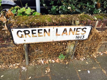
My walk started in earnest at Grange Park Station. A curious little place with the feel of a country halt at platform level. The silent, elevated station seemed to be nestled in an endless sea of trees and rooftops, with the land rising to distant heights to the east and west. Two little shelters and a closed coffee concession at platform level didn't signal much activity, but the ticket office and Oyster readers at the foot of the slope to the street gave away the commuter-belt role of the station at busier times. In the distance, I spied the raised ground which I'd walked just a short while back. I pondered my recent excursions into this landscape which had once been an inert, suburban gap in my atlas - realising how curious it was that so many of my walks over the past months touched on my target today: Green Lanes. This is possibly the longest 'street' in London, at least in terms of a continuously named stretch of road. Its length is testament to its history - an ancient drover's road, worn wide and flat by cattle being walked to Smithfield to be slaughtered and sold, or to the great livestock market at Caledonian Road. The road strikes an ancient path, hugging the same contour line as the New River as it makes a final approach to Islington. Along its length villages and towns have sprung up as proto-service stations, before being swallowed by the conurbation. Some of them persist only in name or memory, others have mutated into distinct settlements within the city often frequented by the Turkish and Greek families which have gravitated towards Green Lanes. Walking this route might have started as a gimmick or conceit - but it had taken on a significance which surprised even me. This approach from the north would tether Highgate to Hackney, link the heights of Alexandra Palace to the lowlands of the Lea Valley, and guide the tiny Moselle towards the mighty Thames. These northern ridges, so long just stops on an Underground map, had suddenly become vital in their ability to explain the topography of North London - and running like a single main vein through the system was Green Lanes.
From Grange Park, I needed to make a short detour to find the start of Green Lanes. In reality it's far from the start of the track, and as I approached Bush Hill by walking a route parallel to the tiny but unseen Salmons Brook, I noted the perfectly straight course of the narrow lane from North to South. If I turned away from London now I'd soon pass through Enfield, and on to Forty Hill, this venerable road slowly aligning with the main road to Cambridge. There was a clear route here which was evidently the northern continuation of Green Lanes - but for me the course lay to the south. A raised grassy bank behind municipal railings masked the course of the New River. I would be crossing and re-crossing this old friend repeatedly on my trek, and it was tough to resist the temptation to walk its grassy bank rather than pounding the pavements today. But that could wait - and after paying my respects briefly to the river as it curved sedately under Ridge Avenue, I turned back to face the beginning of my walk. The origins of Mason's Corner appear lost - whether some local is honoured by this spot, or whether it's a play on the tools of the trade is unrecorded - and now it is marked only by a fading sign on the parade of shops facing the twisting crossroads where Green Dragon Lane meets Green Lanes. There is a dry cleaner, a Chinese takeaway, and the somewhat tired but intriguingly named 'Eagle Letting Bureau' among the premises ranged along this beginning of the road. Somewhere among these businesses is No. 949 Green Lanes - the highest numbered property I could find on the map. I set off at a fair pace - I was aware of being later than I planned, and I hadn't thought through a fitting ending for this walk at all. As I passed an almost unbroken string of small shops, I quickly realised that all of my fraught missions to find breakfast in Central London had been badly misdirected. Here, almost every second store was a café serving a genuinely all-day offering of slick, fried finery. It was hours since my on-train breakfast and the temptation to stop and take the rare opportunity to eat a morning meal was strong. In the centre of the city, breakfast is a concept only - a brief phase which establishments pass through and abandon before most people are ready to eat - especially at weekends. Brunch is no substitute at all, merely a hint at establishing a reasonable drinking hour. But in the suburbs, honest stocky men were returning to their white vans while mopping sauce and grease from stubbled chins even at this late hour. Solid tea mugs left their stains on formica tabletops in an appealingly straightforward fashion, next to mobile phones abandoned for the duration of the breakfast ritual. Nothing was artisanal or locally-produced. Everything was available in larger portions. Green Lanes is typified by these eateries - often run by generations of the very same Greek or Turkish families who have clustered around this byway, performing as local caffs by day alongside their role as busy restaurants and community meeting places. Even when the breakfast aromas ceased as the day drew on during my walk, the smell of charcoal grills replaced it and the establishments filled with young men, talking excitedly in foreign tongues while their elders watched sagely over tiny cups of impossibly strong coffee. This was a challenging walk for an unhealthily caffeine addicted carnivore.
After an initial swing westwards, the road soon found its straight, southern course with the New River meandering back into line after skirting a sizeable sports ground. I was now approaching Winchmore Hill and despite its suburban character, there was a pleasing sense of this village being planned rather than evolving wholly by accident. The main shopping area was arranged around two large triangular junctions, and running between them on each side of Green Lanes were matching ranks of impressive, gabled shops with bright white stone trim. The careful curves of the shopfronts were matched by a newer, 1930s block of offices which echoed their grand facade but in freshly painted white plaster. It was hard not to feel that this was a prosperous corner on first appearances, and I reluctantly pressed on without entering any of the restaurants or stores. I was, it's fair to say, hungry and thirsty. As I progressed south, the road now converging closely with the river, I soon realised that my regular diversions into side roads to peer over the parapet of the frequent river bridges were delaying both the walk and my access to sustenance! I finally found a deceptively large Sainsbury's tucked inconspicuously behind a tall brick wall and headed inside. My frustration with the rest of humanity today quickly resurfaced as the locals of WInchmore Hill did their best to obstruct and irritate me. Once provisioned, I finally escaped back to the road and set off again with fresh determination not to converse with another soul today if I could possibly avoid it. Soon, the river parted company with the road and I turned slightly to the west towards Palmers Green. My previous, brief visit here had been in similarly hungry and challenged circumstances only a month back - but this time at least I saw a little more of the area. By far the most impressive building remains the stylishly municipal Southgate Library with its neat modern extension, which sits beside the crossroads which I'd passed on my last walk. Nearby, the road crosses the broad curve of the New River once again - but I was on the lookout for a different prize. Further south, I triumphantly spied the rather overgrown trickle of Pymmes Brook passing largely unnoticed under Green Lanes. I'd roughly approximated the route of the Brook when I walked it to avoid crossing and re-crossing major roads, but I'd missed some opportunities to see this elusive waterway winding through the suburbs here, and it was good to fill in a little more of the story. Otherwise, Palmers Green felt like a lower-rent Winchmore Hill - less symmetrical, more confused, a little more downbeat and tired.
It was also a long, strung-out sort of place, hugging Green Lanes for a little longer than was necessary or decent. In fact, the thing which finally put paid to the elongated sprawl of Palmers Green was the intrusion of the North Circular. That ever-present thundering gyratory which has slunk it's noisy, reeking way through most of my travels this year crosses Green Lanes at one of the few remaining suburban crossroads on its route. Six lanes of high-speed, through traffic career to a halt at traffic lights where the comparatively ancient but less travelled old arterial crosses on the way to London. Pedestrian access here was scant and provisional. A small group of us, perfect strangers, seemed to be huddled together for safety on the crossing to the central island. I almost hung back here for a picture of the broad sweep of the road west to east. I didn't quite dare though and I found myself scuttling after my new companions only to part company as soon as we found the kerbstones. Perhaps I'd been too hard on humanity today after all? I pondered if a walk of the North Circular was possible, or indeed in any sense advisable, as I trudged a long, straight stretch of the pleasantly suburban road hoping to find a spot to stop and eat. It felt like a future target - if a somewhat masochistic one perhaps? Finally, with the clouds beginning to shuffle overhead to form a solid, grey dome, I found Woodside Park - a deep curved bowl with a playground at the bottom surrounded by a wide sweep of grass which filled the remainder of the large square plot. I found a bench and rested before I headed, temporarily at least, along a road which wasn't strictly Green Lanes at all...
I had been prepared to accept that High Road was a historical blip - a little inconsistency in my conceit to walk the length of Green Lanes which was likely down to some municipal twist or other. I consoled myself by thinking it was still Green Lanes really and that as Wood Green had grown from wayside stop to sprawling village and eventually to a small town in its own right, the civic fathers had needed to mark this change. What surprised me was how different the character of High Road was: how swiftly it switched gears from suburban shopping strip to edgy, urban menace. This was the fringe of Noel Park - purpose-built around 1880 as an early garden suburb in the treacherously damp Moselle Valley then extended out to reach the High Road in the form of decently built brick shopfronts. As I passed the deceptively small frontage of the long, snaking bus garage and the well-established drinking school inhabiting the War Memorial Gardens, the road fell away steeply to reveal a chasm of retail ahead of me. The long terraces of red brick dissolved into a vast glassy cinema complex, then a towering mall development which stacked storey after storey on top of the road. It was fittingly if unimaginatively named The Mall Wood Green. A writhing line of buses ducked in and out of their stops, and people seethed towards me. Turning to look back, a risky move in the pressing human tide, the baleful bronzed glass front of River Park House reared up at me. This blank edifice of not immediately clear purpose is, in fact, the address of numerous departments of the London Borough of Harringey and its partner organisations. Housing the overspill from the inadequate civic hall just a short walk away, the building is disarmingly anonymous - you'd never know it was occupied, let alone so extensively used ostensibly for the public good. As I passed between the ranks of storefronts I realised this was actually rather odd - most malls don't have an outdoor street-front like this. High Road - the proxy for Green Lanes - was hemmed in by this development, dissolved into a glorified underpass. A little delve into the history of the area dates the development to the 1970s, built as Wood Green Shopping City in part on the site of Noel Park and Wood Green Station on the ill-starred Palace Gates line. Opened by HM Queen Elizabeth II in 1981, the centre has undergone several externally evident strata of change - adding housing and parking above a second deck of stores. When a downturn in retail saw it seemingly condemned to house only poundshops, phone accessory booths and charity stores it was saved and invigorated with £30m of investment in 2002. Debenhams signalled their intent to anchor the site - but they didn't follow through, and in 2007 Primark arrived with its ironic burden of post-chav chic. The Mall had found its niche. Its stores outnumbered the mighty Brent Cross now but catered primarily to its local audience. Why go up west or take a bus to an out-of-town retail park when you could strut and leer through Wood Green, gurning at passers-by and howling across the street. Drinking was banned, but a little tot might have calmed these feral tribes which yammered and yelped - men bare-chested, women in jeggings, everyone carefully aligning with a stereotype and defiantly, belligerently proud of it.
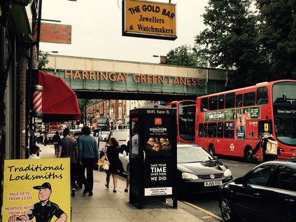
High Road peters out slowly - first, it returns to red brick terraced shops, provided in the late 19th century by the Artizans' Company and filled by slightly off-High Street businesses majoring on serving the diverse ethnic mix of the area. Then it opens out into Duckett's Common, a wide swathe of green stretching along the western edge of the road. As I surveyed the spot for a good picture of Turnpike Lane station, I realised I'd passed this way before while on the trail of the Moselle. A carpet of prematurely fallen autumn leaves filled the common land which I'd crossed on that excursion, and I figured I'd not made a bad job of tracking the hidden river. In fact, it flowed not far from here at all, giving rise to misgivings in the planners' department about the potential for flooding in the foundations of the vast shopping development. Beyond the green which retained the outdoor gym installed in the heady summer of 2012 when we all wanted to improve our athleticism, lay the Harringey Ladder. This long, regular grid of terraced streets leading up the slope towards the railway lines was bisected in its southern reaches by the New River, sidling in from the west. Happily, the main road was once again officially called Green Lanes here and had returned to the mix of small family restaurants and local businesses which typified the street scene further north. The smell of breakfast now completely replaced by charcoal smoke and the tantalising tang of caramelising meat drippings. Meanwhile, the road ahead dipped slightly to pass under a bridge decked out in bright orange Overground lettering: Harringey Green Lanes. I'd never thought hard about this station name before, always assuming it was some quaint play of the regular pattern of avenues climbing the Harringey Ladder. But now Green Lanes had taken on a far more significant part in my London mythologising, and it all began to make sense. I snapped edgily at the bridge with my camera, trying not to catch an unsuspecting shopper in my shot, then headed onwards under the bridge where stairs led up to the platforms. Again, I'd been here before on a railway-related ramble - and it struck me how over the last couple of months I've inadvertently connected up the parts of my London interest by apparently random and disparate bouts of walking the northern suburbs.
Beyond the bridge, a low curved wall signified the former boundary of Harringay Arena. Originally built in 1936 for greyhound racing, ice hockey and boxing, this huge eight-sided sports facility faced post-war decline despite hosting wrestling and basketball during the 1948 Olympic Games, popular concerts and circuses. It even bore witness to an early appearance by a youthful and fresh-faced Billy Graham. But by the mid-1950s despite even this divine intervention, the glamour was fading and after a short life of only 22 years, the site was handed over to a food storage concern. Briefly, in the early 1980s, an open-air market functioned on the near-derelict land, but somewhere in the early years of the 21st century the sorry-looking site was cleared and the Arena Retail Park arrived. An identikit rank of white warehouse blocks ranged around a curve towards a flagship Sainsbury's. Only a tiny plaque and the insignia at the tip of the totem of store names provided any hint of what was once here and how important it was to the businesses around Green Lanes. However, to the west of the road was an altogether more enduring symbol of leisure. Facing off against the blank wall of the vast Homebase store, the north-eastern corner of Finsbury Park slipped unobtrusively into view, giving no clue to just how huge this green space was. Filling the space between the fan of railway lines leading to Moorgate or Kings Cross and the course of Green Lanes, the roughly diamond-shaped park defines the southern boundary of Haringey. Following the road, the ground rose again towards Manor House station, with the cranes and dead grey cladding of new towers signifying the enforced regeneration of Woodberry Down to the east. The New River, my near but standoffish companion on this predominantly road-based ramble swerved east here to circle the reservoirs which had formed yet another earlier walk in this area and I found myself on a suddenly quiet, mainly residential stretch of Green Lanes. It felt a world away from the noise and bustle of its beginnings, or the dreary retail chasm of High Road. A long hoarding, masking the development spelt out the dominant message in capital letters which revealed a glimpse of an evening skyline behind the text: ENJOY PARK AND WATERSIDE LIVING AT WOODBERRY DOWN it twinkled, invitingly. There was little to suggest this was an area which once encapsulated the equitable vision of municipal housing provision in which the Borough of Hackney was something of a pioneering force. Little too to remind the prospective tenant of just how low this estate had sunk before Hackney Council were forced to address its future. This was all about shifting units - preferably off-plan and before demolition was done or a brick had been laid if possible. Unexpectedly, between two incomplete and fairly inauspicious looking new low-rise brick blocks fronting the street a new vista had opened giving a sudden and startling view across the reservoirs. It was an unexpected and tantalising glimpse of a huge sky and a grey shimmer of reflected tower blocks - but it was cordoned-off and would, presumably be gated when complete. Even the view was to be sequestered for those paying the premium it seemed. I toyed with a diversion around the great pumping-station turned climbing venue of The Castle to see the waters, but decided that given my late start and the threatening weather I should press on towards London.
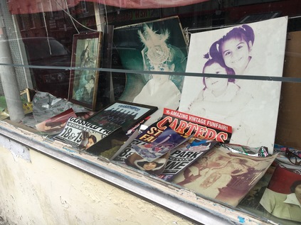
South of Woodberry Down, Green Lanes forms a hazy, meandering boundary between Islington and Hackney as both head for their appointments with the City. Local allegiances are clear here, with 'matchday parking' notices for football at Emirates Stadium, nestling in the nook of a railway junction away to the west. The traffic is sparser and the road is lined by mid-century apartment blocks which glower over the sunbleached grass of Clissold Park. The park extends east, almost reaching the curious urban arbour of Abney Park Cemetary - and I realise again that my history of walks is converging here on this ancient way. The road forks here, and the New River has one last impression to make: underground since it skirted the reservoirs, Petherton Road is divided by a grassy median which marks the former path of the now buried watercourse. If I followed this fork, I could find its last above-ground stretch in Canonbury - but that's another walk for another visit. Instead, I turned south-east, where Green Lanes finds the energy for one last run of shops and cafés before it gives up. Among them is a curious, closed shop filled with what appears to be family memorabilia. Inside is chaos, unopened post and a tumble of furniture. The last building on Green Lanes - or indeed the first should one take the road northwards - was a fitting gateway: a bold, conical brick spire atop a row of Victorian shops. The symmetry is broken though, as the western side of the road has been redeveloped into an anodyne stretch of modern blocks. This timid terminus seemed an inauspicious end to this once vital route from the north. Well established trees screen Newington Green from sight, while buses circle the railings to terminate here. There is an air of faded gentility which is slowly being driven out by hipster eateries and new money. It felt like anywhere on the northern fringe of the city. In transition. My choice is to turn south towards Essex Road, completing the ancient route to town or east towards Dalston and more familiar territory. I head east, along the railway and through the backstreets where Islington finally submits to becoming Hackney. The sun is suddenly beating down again, and the clamour and reek of Ridley Road market is across the street. It feels like a long way from that rural scene at Grange Park station. Like a different city, and certainly a very different time.
You can see a gallery of photographs from the walk here.
Lost::MikeGTN
I've had a home on the web for more years than I care to remember, and a few kind souls persuade me it's worth persisting with keeping it updated. This current incarnation of the site is centred around the blog posts which began back in 1999 as 'the daylog' and continued through my travels and tribulations during the following years.
I don't get out and about nearly as much these days, but I do try to record significant events and trips for posterity. You may also have arrived here by following the trail to my former music blog Songs Heard On Fast Trains. That content is preserved here too.
